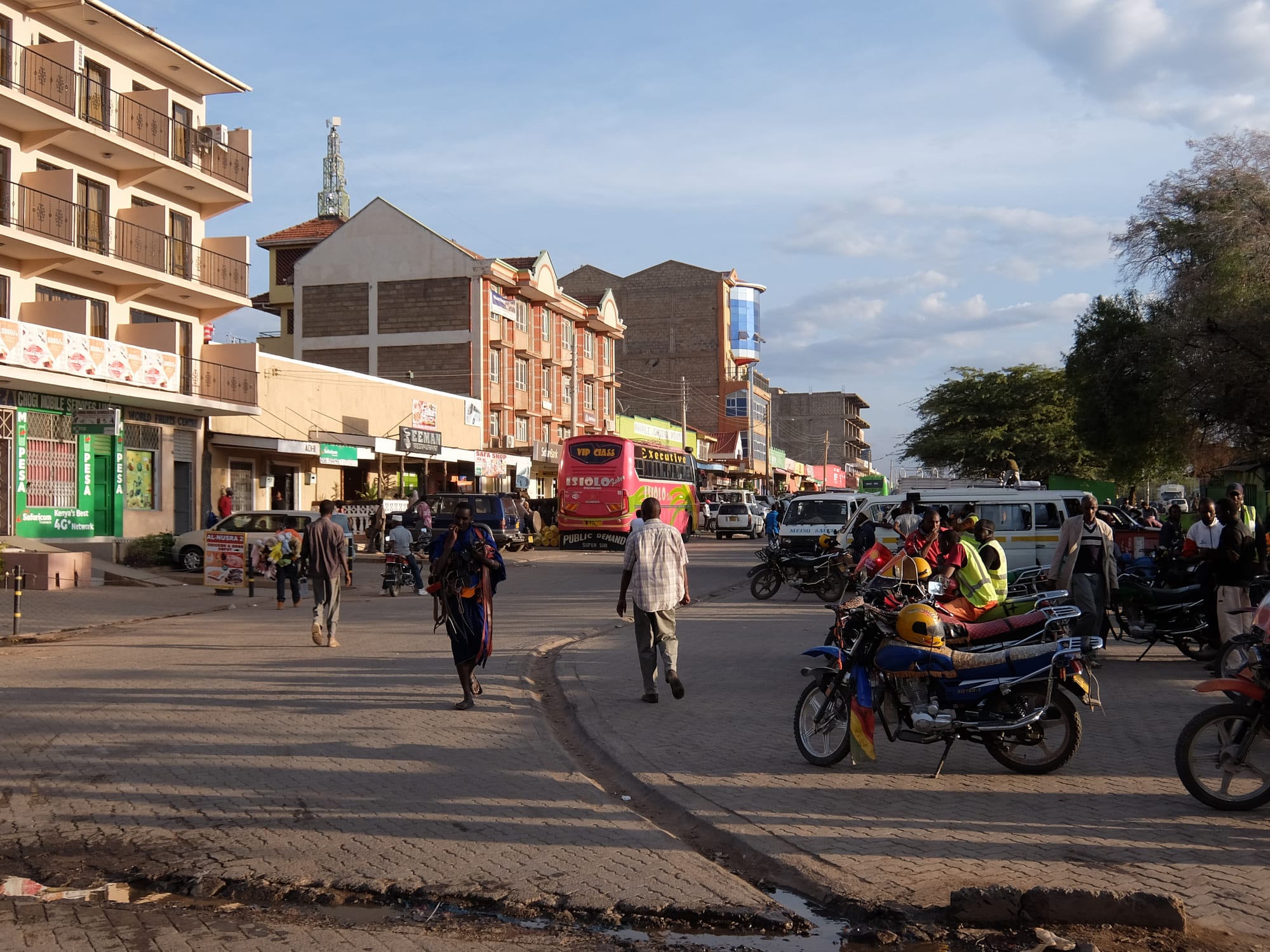
A wide main street in Isiolo with low shops, parked motorbike taxis, a bus and people walking in late afternoon light

Mount Kenya, Meru & the East, Kenya

Isiolo

The main street of Isiolo, with motorbike taxis waiting and a long-distance bus at the roadside. (Macabe5387 / Wikimedia Commons · CC BY-SA 4.0)

A frontier town in dry bush country north of Mount Kenya, where the highland farms end and the roads into Kenya's northern drylands begin. Borana, Somali, Turkana, Samburu and Meru communities trade in its streets, livestock and camels are its business, and the reserves along the Ewaso Ng'iro river lie a short drive to the north.

Neighbourhoods

  • Town centre
    • First-time visitors
    • Markets
    • Close to transport

    A few blocks of shops, hotels, banks, tea rooms and the bus stage strung along the highway, busy with traffic heading north and with motorbike taxis. Almost everything a traveller needs is on or just off the main street.

    Open in Maps
  • The market and livestock yards
    • Markets
    • Local life

    The trading heart of the town, where produce trucked up from the highlands meets livestock brought in from the rangelands, and where camels, goats and cattle change hands on market days.

    Open in Maps
  • The Wabera and Bulapesa side
    • Local life
    • Value accommodation

    Residential streets and small estates spreading out from the centre, with mosques, churches, schools and cheap eating houses, and newer building along the roads out of town.

    Open in Maps
  • The Archer's Post road
    • Safari access
    • Countryside

    The northern approach, where the town thins into acacia bush and the tarmac runs on towards the reserves and the desert counties. Camps and lodges lie off this road on the way to the Ewaso Ng'iro.

    Open in Maps

Things to do

In the town

  • Isiolo Airporttransit hub

    The airport on the edge of the town, also called Isiolo International Airport, with a single asphalt runway 2,500 metres long that straddles the Isiolo–Meru county boundary.

    Open in Maps

Short trips to the reserves

  • Samburu National Reservepark

    Dry bush and doum palms along the Ewaso Ng'iro river, known for Grevy's zebra, reticulated giraffe, gerenuk and oryx, along with elephant, buffalo and all three big cats.

    Open in Maps
  • Buffalo Springs National Reservepark

    The reserve on the southern side of the Ewaso Ng'iro, named after an oasis of clear water at its western end, sharing its wildlife with Samburu across the water.

    Open in Maps
  • Shaba National Reservepark

    A rugged reserve of lava ridges, springs and riverine forest east of the main road, associated with the conservationist Joy Adamson.

    Open in Maps
  • Archer's Postattraction

    A settlement in Samburu County at the gates of the reserves, a Samburu trading and herding centre and the last town before the long road north.

    Open in Maps

Short trips further afield

  • Lewa Wildlife Conservancypark

    A private conservancy in Meru County, north of Mount Kenya and south of Isiolo, holding more than a tenth of Kenya's eastern black rhino and the world's largest single population of Grevy's zebra.

    Open in Maps
  • Meru National Parkpark

    A park of rivers and open bush where George and Joy Adamson raised Elsa the lioness, and where she is buried.

    Open in Maps
  • Nanyukiattraction

    A market town in Laikipia County just north of the equator and north-west of Mount Kenya, and a base for people climbing the mountain.

    Open in Maps
  • Mount Kenya National Parkpark

    The national park around Africa's second-highest mountain, a UNESCO World Heritage Site of forest, moorland, tarns and glaciated peaks.

    Open in Maps

Seasonal events

  • Livestock market daysweekly, all year

    Herders bring camels, goats and cattle in from the rangelands to the yards on the edge of town, the busiest and most characteristic gathering of the week.

  • Ramadan and Eidvaries with the Islamic calendar

    In a town with a large Muslim population, the fasting month changes the rhythm of the day and the streets fill after sunset; Eid brings family meals and new clothes.

  • The long rainsMarch to May

    Rain turns the bush green, fills the seasonal riverbeds and scatters the herds across fresh grazing; dirt roads off the highway can become impassable.

  • The dry monthsJune to October

    The hottest, dustiest stretch, when wildlife concentrates along the Ewaso Ng'iro and the reserves are at their best for viewing.

Eat and drink

Long-standing places and food districts in Isiolo. Hours, ratings and directions come from your maps app, always current.

Isiolo classics

  • Camel meat and camel milkrestaurant

    Camel is eaten grilled or stewed and the milk drunk fresh or soured, sold in the town's eating houses and at the market in a place where camels are the mainstay of the rangelands.

    Open in Maps
  • Nyama choma and goatrestaurant

    Goat roasted over charcoal and ordered by weight, cut up with kachumbari and eaten with ugali, is the town's social meal.

    Open in Maps

Markets and food streets

  • Isiolo town marketmarket

    Produce brought up from the highlands, dates, khat, dried goods, meat and milk, traded alongside beadwork and livestock from the rangelands.

    Open in Maps
  • Somali tea houses on the main streetcafe

    Tea houses and canteens along the highway serve sweet spiced tea, canjeero pancakes, rice and pasta with goat or camel, and chapati, to travellers heading north.

    Open in Maps

Experience Isiolo

History

The country around Isiolo was grazing land long before there was a town: Borana and Somali herders moving south and west with camels and cattle, Samburu on the rangelands to the north, Turkana to the west and Meru farmers on the mountain slopes to the south. The British administered the whole of the north as the Northern Frontier District, a closed area where movement required a permit, and Isiolo grew at its southern edge as the administrative post and supply point where the highlands met the drylands.

Its population owes much to the colonial army: the town grew around the military camps placed here, and Somali and Borana traders settled alongside them, giving Isiolo the Muslim commercial quarter that still shapes its streets, with Meru farmers coming up from the south. As independence approached, the future of the Northern Frontier District was contested, and the insurgency known as the Shifta War, which followed from 1963 to 1967, left the district under security operations for years afterwards and the area poorly served by government investment.

For decades Isiolo was known mainly as the place where the tarmac stopped. That changed with the paving of the highway north through Marsabit to Moyale, completed in 2016, and with devolution in 2013, which made the town the headquarters of Isiolo County. Plans under the LAPSSET corridor scheme have designated Isiolo for major road, rail and airport investment as a hub linking the coast with Ethiopia and South Sudan, and an airport was built on the edge of the town, though much of the wider scheme has moved slowly.

Culture & Customs

Few Kenyan towns are as mixed. Borana, Somali, Samburu, Turkana, Meru and Kikuyu families trade in the same streets, and it is normal to hear four or five languages between the market and the bus stage. Islam is strongly represented, with mosques in the centre and the call to prayer over the main street, and Christian churches serve the Meru and up-country communities; the two have long shared the town, and the county's politics are organised around keeping that balance.

Pastoral life sets the tone. Wealth is counted in camels, cattle and goats, and herding families move with the rains between grazing areas, coming into town to sell animals and buy grain, sugar and tea. Samburu and Borana beadwork, cloth and ornament are everyday dress rather than costume. Hospitality is formal: tea is offered before business, elders speak first, and disputes over grazing and water are still settled in large part by councils of elders.

Miraa, the stimulant leaf grown in the Nyambene hills of Meru to the south, moves through Isiolo in fast pick-ups every afternoon and is chewed in groups over long conversations. Camel racing and livestock shows appear at county celebrations, and the town's identity as a frontier — the last place before the north — is something its people wear with some pride.

Daily Life

About 78,000 people live in the town, in a county of about 270,000 spread very thinly over dry rangeland. Livestock is the economy: camels, goats, sheep and cattle raised on the range, traded in the yards on the edge of town and trucked to Nairobi, along with milk, hides and meat. Trade and transport come next, since everything moving north or coming south passes through, and the safari lodges and camps along the Ewaso Ng'iro employ drivers, guides and staff from the local communities.

The day starts at first light and slows in the heat of the afternoon, when the tea houses fill and miraa arrives from the south. Markets are busiest in the morning; buses for Nairobi and Marsabit leave early; and the evening brings people out onto the main street once the sun has dropped.

The pressures are those of the drylands. Repeated droughts have killed herds and pushed families into the town's outskirts, water is scarce and expensive, and competition over grazing and water has caused violence between communities in parts of the county. Against that, devolution and the new highway have brought county offices, schools, health facilities and construction work, and Isiolo's position on the road north gives it a role in every plan for Kenya's northern development.

Food

Isiolo eats like the drylands. Goat and camel are the meats: grilled over charcoal as nyama choma and ordered by weight, or stewed slowly and served with rice or ugali. Camel milk, fresh or soured, is drunk daily and sold in containers at the market, and camel meat is a normal part of the menu here in a way it is not in most of Kenya.

Somali cooking is everywhere in the town's eating houses. Canjeero, a thin, slightly sour pancake, is a common breakfast; rice and spaghetti are served with goat or camel and a banana on the side; sambusas are fried for the afternoon; and sweet, heavily spiced tea, flavoured with cardamom, cinnamon and cloves, is drunk all day. Borana households add their own milk-and-meat traditions, and up-country canteens serve ugali with sukuma wiki, beans and githeri for those who want them.

Dates, honey and ghee are sold in the market, produce is trucked up from the highland farms around Meru and Nanyuki, and water is a commodity in its own right. Alcohol is available in some bars and hotels but plays little part in public life in much of the town, where tea is the social drink and miraa the afternoon habit.

Planning tools

Budget

The town itself is cheap: guesthouses, tea houses and matatus cost very little. The expense comes with the country around it — park fees at Samburu, Buffalo Springs and Shaba, conservancy rates at Lewa, and the 4x4 with a driver that any trip north of the town really requires. Camps and lodges along the river range from simple to very expensive.

Daily Budget Midrange
USD 70–160 in the town; a vehicle, park fees and a river camp raise this sharply
Daily Budget Shoestring
USD 25–45 in the town (guesthouse, local food, matatus); park days cost far more

Park and conservancy fees are charged in US dollars per person per day; agree a vehicle and driver for the reserves in advance, and carry cash, as card payment is limited.

Best Time to Visit

June to October and January to February are the driest and best months for the reserves, when animals gather along the Ewaso Ng'iro and the tracks are firm. The long rains from March to May and the short rains later in the year green the bush and scatter the wildlife, and can wash out dirt roads. Heat is constant all year.

Suggested Number of Days

The town is a staging post and needs no more than a day. Three or four suit a stay in the reserve country along the river, and longer again for anyone continuing north into the desert counties, which is a serious undertaking rather than a day trip.

First Visit
1 day
With Surroundings
3–4 days

Transportation

Matatus, shared taxis and long-distance buses run south to Nanyuki, Meru and Nairobi and north along the paved highway towards Marsabit and Moyale, and boda-boda motorbike taxis cover the town. There is no public transport into the reserves: visitors arrive with a hired vehicle and driver, on an organised safari, or by light aircraft to the reserve airstrips.

Use a 4x4 with a driver who knows the routes for anything off the tarmac, carry water and fuel, and travel between towns in daylight.

Airport & Station Connections

Isiolo lies about 285 km north of Nairobi by road through Nanyuki or Meru, and buses and shared vehicles make the trip daily. The airport on the edge of town has a 2,500-metre paved runway, and the reserves have their own airstrips served by safari flights from Nairobi's Wilson Airport. North of the town the paved highway continues to Marsabit and the Ethiopian border at Moyale.

Walkability

The town is small and flat, and the shops, market, stage and hotels are within a few minutes of each other along the main street, though the heat and the dust make the middle of the day uncomfortable and heavy lorry traffic runs through the centre. Anything beyond the town is reached by vehicle; the bush begins at once and should not be walked into.

Safety

Isiolo is a working frontier town, generally calm for travellers passing through, with petty theft around the market and the bus stage the usual risk. The wider picture is more complicated: clashes between pastoral communities over grazing, water and cattle affect parts of Isiolo and Marsabit counties, banditry has occurred on some northern roads, and governments advise against travel to the counties near the Somali border. Malaria is present, and the reserves carry the ordinary hazards of wildlife country.

Avoid the north-eastern counties and the immediate Somali border, travel in the Marsabit area only with local advice, and take altitude sickness seriously on Mount Kenya. Travel north of the town only with an operator who checks conditions along the route, keep to vehicles inside the reserves, and take malaria precautions. Check current official travel advice before travelling.

Climate

Hot, dry and dusty for most of the year at about 1,100 metres, with two rainy seasons rather than a hot and a cold one. The long rains fall from about March to May and the short rains from October to December, both unreliable, and drought is a recurring feature of this country.

Summer
January to March is hot and dry, with days often above 32°C and cool, clear nights
Winter
June to September is a little cooler and dry, with days around 30°C and dust on the wind

Local Customs

Isiolo is a meeting point of Borana, Somali, Turkana, Samburu and Meru communities, with a large Muslim population alongside Christian congregations, and Borana, Somali, Samburu and Swahili are all heard in the market. Dress is modest, particularly for women and around mosques, greetings are formal and unhurried, and elders are addressed first. Khat, known here as miraa and grown in Meru, is chewed openly in the afternoon.

Ask permission before photographing people, herds or mosques, and expect a request for payment for posed photographs; dress covering shoulders and knees; alcohol is sold but is not part of public life in much of the town.

Common Payment Methods

The currency is the Kenyan shilling. Mobile money is used for almost everything, from fares to market purchases, and cards are accepted at safari lodges but rarely in the town. ATMs are on the main street; cash should be drawn here before heading north, as banks are scarce beyond the town.