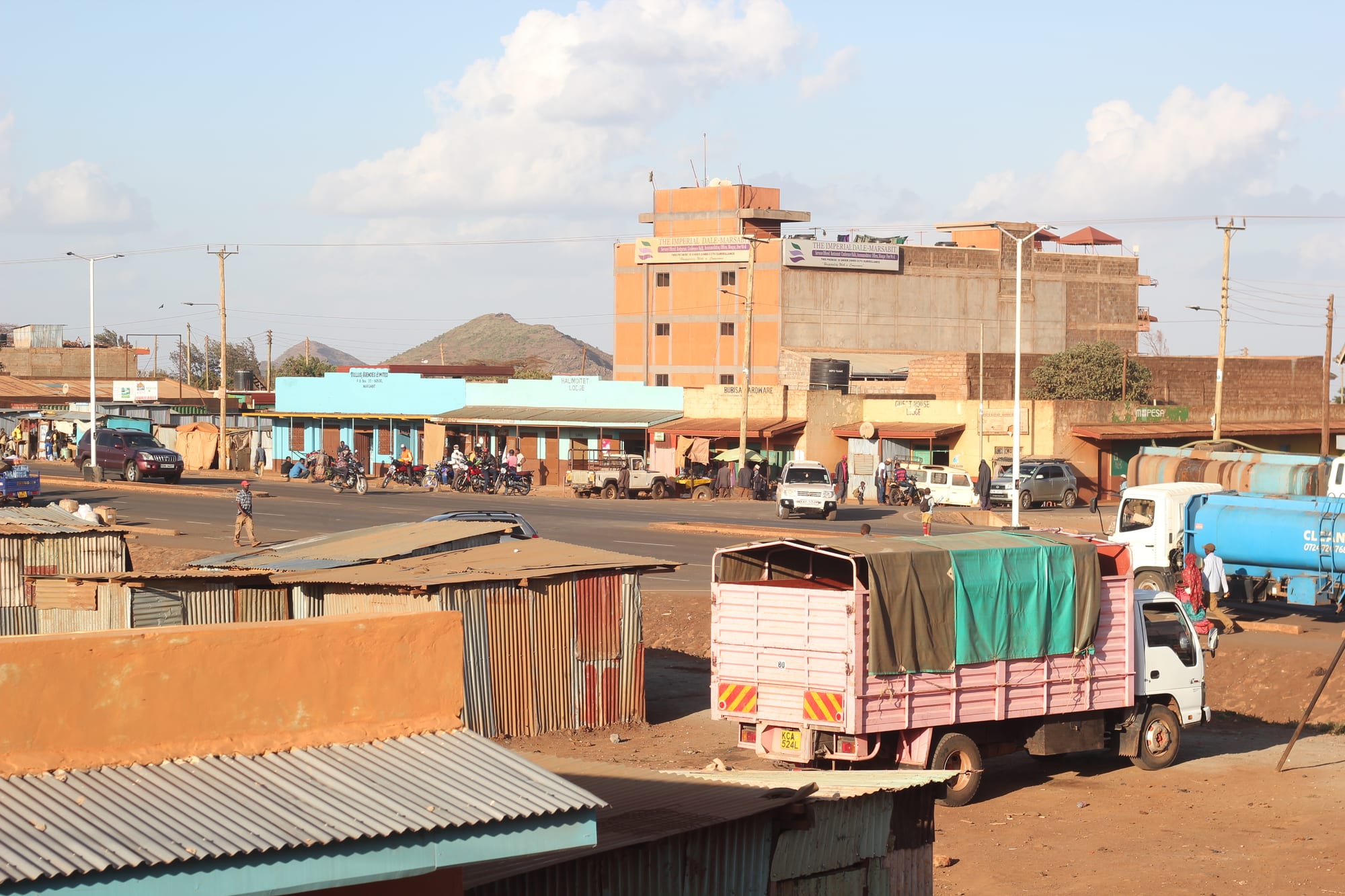
A wide dusty street of low shopfronts and corrugated-iron stalls in Marsabit, with a lorry in front and a hill behind

Mount Kenya, Meru & the East, Kenya

Marsabit

Marsabit, the county town on the slopes of Mount Marsabit in northern Kenya. (Kandukuru Nagarjun / Wikimedia Commons · CC BY 2.0)

The capital of Marsabit County in northern Kenya, built on the slopes of Mount Marsabit, a forested shield volcano that rises green and misty out of desert plains. It is a market and administrative centre for Borana, Gabbra, Rendille and Burji herding communities, a stop on the highway towards Ethiopia, and the gateway to a national park of crater lakes and elephants.

Neighbourhoods

  • Town centre
    • First-time visitors
    • Markets
    • Transport

    A few blocks of shops, guesthouses, county offices, mosques and churches along the main street, with the bus and lorry stage at its heart. Everything a traveller needs in Marsabit is within a short walk of it.

    Open in Maps
  • The market quarter
    • Markets
    • Local life

    Stalls and open ground where livestock, milk, miraa, vegetables trucked up from the highlands and goods brought down from Ethiopia change hands. It is the clearest place to see the county's mix of Borana, Gabbra, Rendille, Burji and Somali communities.

    Open in Maps
  • The forest edge
    • Quiet and residential
    • Cool air
    • Walks

    The upper, wetter side of town where houses and smallholdings give way to the indigenous forest of Mount Marsabit. Mist sits here for much of the morning and the temperature drops noticeably above the centre.

    Open in Maps
  • The highway approaches
    • Transport
    • Long-distance buses

    The strip along the tarmac road running south to Isiolo and north towards Moyale, with fuel stations, lorry parks, workshops and cheap lodgings serving the traffic between Kenya and Ethiopia.

    Open in Maps

Things to do

The mountain and its park

  • Marsabit National Parkpark

    Indigenous forest and crater lakes on the volcano above the town, with elephant, buffalo, leopard and a long list of birds, and one of the few places in northern Kenya where the country is green.

    Open in Maps
  • Mount Marsabitviewpoint

    The basaltic shield volcano the town is built on, dense with forest and pitted with craters and maars — known locally as gofs — at least two of which hold lakes.

    Open in Maps
  • Lake Paradiseattraction

    A crater lake in Gof Sokorte Gurda inside the park, ringed by forest and rich in birds, where the American film-makers Martin and Osa Johnson lived in the 1920s making wildlife documentaries.

    Open in Maps

In the town

  • Marsabit livestock and produce marketmarket

    The trading ground where camels, goats and cattle are bought and sold alongside milk, grain and goods from Ethiopia, and the social centre of the wider county.

    Open in Maps

Short trips from the town

  • Chalbi Desertattraction

    A flat saline basin north-west of the mountain, a dry lake bed that turns to glaring white salt crust in the dry months and to shallow water after heavy rain, crossed by Gabbra herders and their camels.

    Open in Maps

Eat and drink

Long-standing places and food districts in Marsabit. Hours, ratings and directions come from your maps app, always current.

Marsabit classics

  • Camel milk and roast meat in the town centreneighborhood

    Fresh and soured camel milk, goat and camel meat grilled or boiled, and rice or pasta served with a bowl of broth in the small hotelis along the main street.

    Open in Maps
  • Somali and Borana tea housescafe

    Sweet spiced tea, canjeero pancakes and mandazi, drunk through the day by traders, drivers and herders in from the plains.

    Open in Maps

The market

  • Marsabit marketmarket

    Milk in plastic jerrycans, dried meat, maize, beans and vegetables brought up by lorry from the highlands, with dates, pasta and spices carried down from Ethiopia.

    Open in Maps

Experience Marsabit

History

Mount Marsabit has drawn people for as long as the plains around it have been dry. Its forest, springs and crater lakes are the only reliable water for a great distance, and Borana, Gabbra, Rendille and Samburu herders have moved their camels, cattle and goats towards the mountain in drought for centuries, watering stock at wells sunk into the lava and at the pools in the craters. Control of that water shaped the politics of the region long before any state reached it.

A British administrative post was established on the mountain, and Marsabit became the headquarters of a district within the Northern Frontier District, created in 1925 as a closed area where movement was restricted and which was administered with a light and largely military hand. Traders, many of them Burji from southern Ethiopia, settled around the station and gave the town its farming and commercial character. In the 1920s and 1930s the crater lakes and the forest elephants brought hunters, naturalists and film-makers, and the lake they called Paradise became briefly famous abroad.

Independence in 1963 was followed by the Shifta War in the north, and security operations and restrictions continued long afterwards. Marsabit remained remote: until the 2010s the road south was a punishing dirt track, and the tarmac highway to Isiolo and Moyale, completed in 2016, changed the town more than anything since its founding. Devolution in 2013 made it a county capital with its own government and budget. In April 2006 a Kenya Air Force aircraft crashed on the mountain, killing 14 of the 17 people on board, an event still marked in the county.

Culture & Customs

Marsabit is one of the most ethnically layered towns in Kenya. The Borana, an Oromo-speaking people with strong links across the Ethiopian border, are the largest group in and around the town; the Gabbra and Rendille are camel herders of the desert to the north and south; the Burji are farmers and traders, many of whose ancestors came from Ethiopia; and there are Somali, Samburu, Turkana and highland Kenyan communities as well. Islam and Christianity are both strongly present, often within the same street.

Pastoral life sets the tone. Wealth, marriage, status and obligation are all counted in livestock, and camels in particular carry a weight that outsiders easily miss. The singing wells just outside the town are the best-known expression of it: deep wells at which men form a human chain to pass water up to the troughs, keeping time with call-and-response songs, and calling each herd to drink in turn. Songs, blessings and age-grade ceremonies continue to structure community life, and elders retain real authority in settling disputes over grazing and water.

Competition over that grazing and water, sharpened by drought, has at times set communities against one another in the county, and the parent region's caution about clashes between pastoral communities applies here. The town itself is a meeting ground, where the county's languages — Borana, Gabbra, Rendille, Burji, Somali, Swahili — are heard within a few paces of each other, and where market day is as much a social occasion as a commercial one.

Daily Life

Marsabit is a small town, the centre of a county of about 460,000 people spread over 66,900 square kilometres — the second largest county in Kenya, with a density of six people to the square kilometre. Days begin early and cool, with mist on the forest and milk coming in from the herds; the market fills through the morning, offices and shops keep to the middle of the day, and the town is quiet after dark.

The economy is livestock, trade and government. Camels, goats and cattle are the main wealth of the county and the main business of the market, milk is sold fresh and soured, and the county government, schools, hospitals and aid organisations are the significant formal employers. The mountain's slopes support farming that is impossible elsewhere in the county — maize, beans, vegetables and some coffee — and the highway has brought shops, fuel stations and lorry traffic.

Drought is the constant issue. Repeated failed rains have killed herds, pushed families off the plains and into settlements around the town, and left many dependent on relief food. Water supply, schooling for children of mobile families, insecurity in parts of the county and the pressure on the mountain's forest are the recurring concerns; wind power and road building near Loiyangalani and along the highway have brought work and new arrivals to parts of the county.

Food

Northern Kenyan food rests on livestock. Camel milk, drunk fresh or soured, is a daily staple and is sold in jerrycans in the market; goat and camel meat are the main meats, boiled with broth or grilled over charcoal. Rice or pasta with meat and a bowl of soup is the standard hot meal in the town's small restaurants, a pattern shared with Somali and Ethiopian cooking across the region.

Breakfast is often canjeero, a thin, slightly sour pancake, or mandazi fried dough, with strong sweet tea spiced with cardamom, ginger and cloves. Ugali and sukuma wiki — maize porridge with braised greens — appear alongside them, brought by highland Kenyan traders and civil servants, and the mountain's farms add maize, beans, potatoes and vegetables to a diet that would otherwise be almost entirely milk and meat.

Proximity to Ethiopia shows in the shops: pasta, dates, spices and cooking oil come down the road from Moyale, and injera and Ethiopian stews turn up in some kitchens in town. Miraa, trucked up from the Nyambene hills far to the south, arrives daily and is chewed widely. Almost all fresh produce is imported by lorry, so supply and price depend on the state of the road.

Planning tools

Budget

Food, tea and simple lodgings in Marsabit cost very little, but getting there and moving around is expensive. The distances are long, fuel is dear, a 4x4 with a driver is effectively necessary off the highway, and the national park charges an entry fee in US dollars. Supplies are trucked in, so shop prices are higher than in the highlands.

Daily Budget Midrange
USD 90–190 in town, far more once a 4x4, a driver and park fees are added
Daily Budget Shoestring
USD 30–50 (basic guesthouse, local food, shared transport on the highway)

Carry enough cash for several days and fill the tank at every opportunity; vehicle hire, fuel and park fees, not accommodation, make up most of a northern budget.

Best Time to Visit

June to August and January to February are the usual months, when the roads and tracks are firmest. The mountain is cooler and mistier than the surrounding country at any time of year. Rain between March and May, and again around November, can make the murram roads off the tarmac impassable and cuts off outlying settlements.

Suggested Number of Days

A day or two is enough for the town and the forest park above it. Three or four allow the desert country beyond the mountain. Most visitors are here as part of a longer northern journey, and the length of stay usually depends on vehicles and road conditions rather than on the sights.

First Visit
1–2 days
With Surroundings
3–4 days

Transportation

The tarmac highway from Isiolo to Moyale runs through Marsabit and is the lifeline of the county, carrying buses, lorries and Ethiopian freight. Within town, walking and boda-boda motorcycle taxis cover everything. Everywhere off the highway — the desert, the outlying settlements and the tracks across the plains — needs a high-clearance 4x4, spare fuel and water.

Travel between towns in daylight, ask locally about the state of the roads and the situation along them before setting out, and do not rely on finding fuel outside the main centres.

Airport & Station Connections

Marsabit is about 270 km north of Isiolo on the paved highway, a drive of roughly four to five hours, and some 550 km from Nairobi by way of Isiolo and Archers Post; buses run the route, mostly overnight or early in the morning. The tarmac continues north to the Ethiopian border at Moyale. Two airstrips serve charter aircraft: Marsabit Airstrip, close to town on the Moyale road, and Segel, further out towards the Chalbi.

Walkability

The town is small and easily walked end to end in twenty minutes or so, with the market, the lodgings and the offices all close together. Streets are dusty or muddy depending on the season, street lighting is limited, and the climb towards the forest edge is steeper than it looks at this altitude.

Safety

Marsabit town itself is generally quiet, and the everyday risks are theft in crowds, road accidents and the hazards of long, empty roads. The wider county is harder country: competition over grazing and water has brought clashes between pastoral communities, the highway crosses very isolated stretches, and government advice on the north and the Ethiopian border changes with conditions.

Avoid the north-eastern counties and the immediate Somali border, travel in the Marsabit area only with local advice, and take altitude sickness seriously on Mount Kenya. Check current official travel advice before travelling.

Climate

The mountain makes its own weather. While the plains around it are hot and arid, the town sits high enough to catch cloud and drizzle, and is noticeably cooler, greener and mistier than anywhere nearby. Rain is unreliable and falls mainly between March and May and around November.

Summer
January to March is the hottest and driest spell, around 25–30°C in town and far hotter on the plains below
Winter
June to August is cool and often misty on the mountain, around 18–24°C, with cold nights

Local Customs

Marsabit is shared between Borana, Gabbra, Rendille, Burji and Somali communities, Muslim and Christian, and courtesies matter. Greetings are long and unhurried, elders are greeted first, and livestock — above all camels — carry status and are not a casual subject. Wells and watering points are managed under community rules.

Dress modestly, ask before photographing people, livestock or wells and expect a request for payment, avoid discussing community disputes or land, and treat any offer of milk or tea as hospitality to be accepted.

Common Payment Methods

The currency is the Kenyan shilling, and mobile money is the usual way to pay, though the network can be patchy away from the town. There are banks and ATMs in Marsabit, but none for a long way in any direction, so cash should be drawn here. Cards are of little use outside a handful of lodgings.