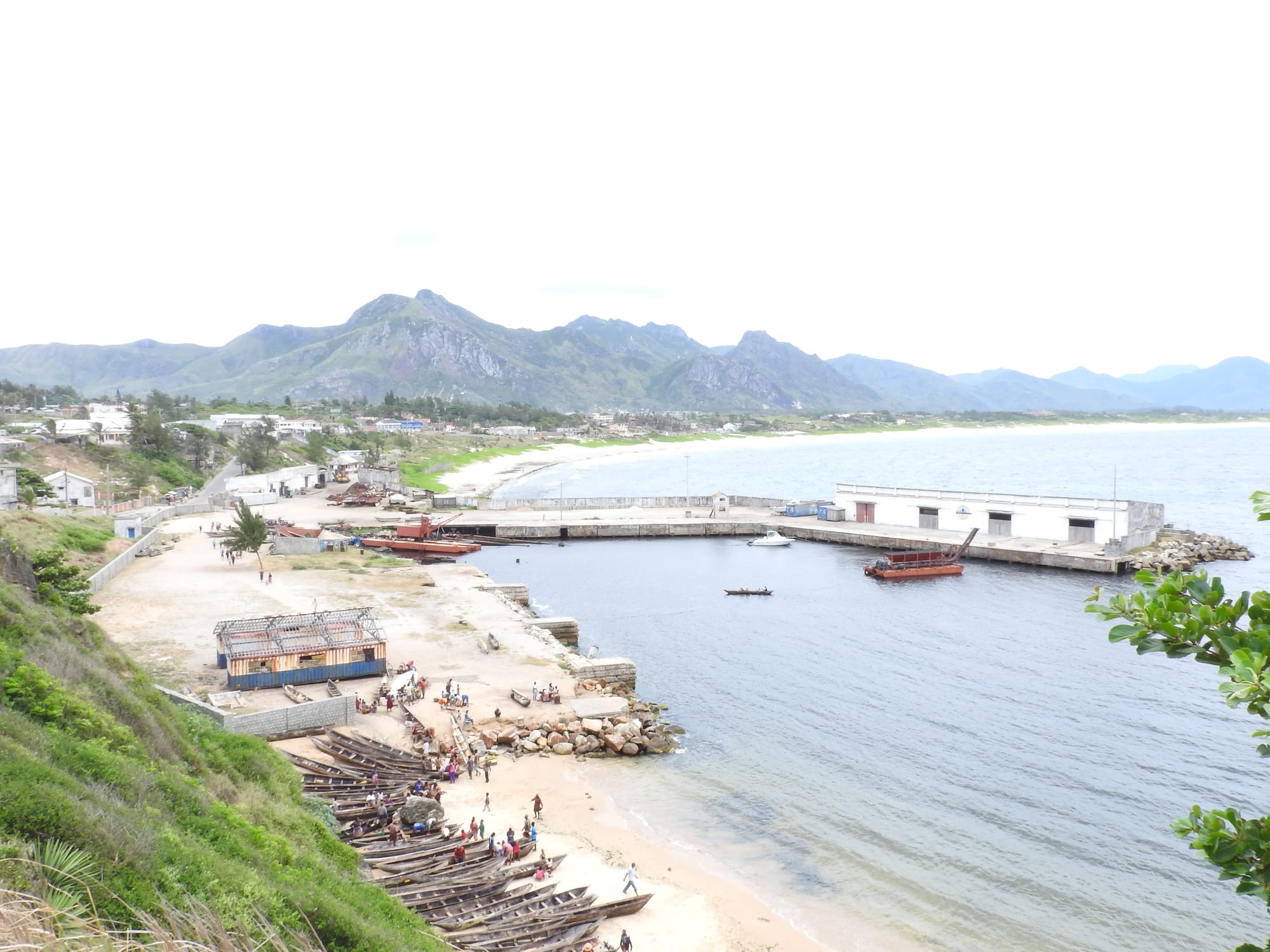
A small harbour with wooden fishing canoes drawn up on the sand, a jetty and warehouses, and green mountains behind the town

Isalo, Toliara & the South, Madagascar

Tôlanaro

The old fishing harbour at Tôlanaro, with the Anosy mountains behind the town. (Jose Antonio / Wikimedia Commons · Public domain)

A port town on Madagascar's south-eastern corner, widely known by its French name Fort Dauphin, set on a peninsula of beaches with the Anosy mountains rising behind it. Founded as a French trading post in 1643 in the land of the Antanosy, it now lives on fishing, a mineral sands mine and its position between rainforest and spiny forest.

Neighbourhoods

  • The town centre
    • Local life
    • Markets
    • First-time visitors

    The working heart of the town on the neck of the peninsula, around the market, the banks, the taxi-brousse stand and the old fort site. Streets are short, hilly and busy in the morning, and most services are within a few minutes' walk of each other.

    Open in Maps
  • Libanona and the headland
    • Beaches
    • Quiet and residential
    • Views

    The southern side of the peninsula, where a small beach sits between rocky headlands below grassy slopes and a scatter of houses and guesthouses. It has the best views back over the bay and out to the open Indian Ocean, and the water is exposed enough for surf.

    Open in Maps
  • The bay and the harbour
    • Local life
    • Boats
    • Close to transport

    The sheltered northern side, with the old fishing port, boatyards, warehouses and the long sweep of sand along the bay. Pirogues and small trawlers land here, and the road west runs on towards the deep-water port and the airport.

    Open in Maps

Things to do

Beaches and viewpoints

  • Libanona Beachbeach

    A beach on the headland on the town's ocean side, within walking distance of the centre and one of the most visited spots around Tôlanaro.

    Open in Maps
  • Pic Saint-Louisviewpoint

    The 529-metre peak just north of the town, also called Mount Bezavona, where the Anosy range ends, climbed for a view over the peninsula, the bays and the mountains inland.

    Open in Maps
  • The bay beachesbeach

    Long stretches of pale sand curve around the northern bay towards the mountains, used by fishing crews and quiet outside the town itself.

    Open in Maps

Nature near the town

  • Nahampoana Reservepark

    A 67-hectare reserve at the foot of Pic Saint-Louis, founded around 1900 as a botanical acclimatisation station for useful plants and now home to many endemic species.

    Open in Maps
  • Lokaroattraction

    A stretch of coast outside the town and one of the most popular excursions from Tôlanaro.

    Open in Maps

Short trips from the town

  • Andohahela National Parkpark

    A park north-west of the town that spans rainforest on one side of the Anosy range and spiny forest on the other, part of the Rainforests of the Atsinanana World Heritage Site, with fifteen lemur species recorded.

    Open in Maps
  • Berenty Reservepark

    A small private reserve on the Mandrare river near Amboasary Sud, about 70 kilometres west, in spiny forest, and a long-standing site for the study of ring-tailed lemurs.

    Open in Maps
  • Sainte Luce Reservepark

    A small reserve in one of the last intact coastal rainforests in Madagascar, north-east of the town, with ebony forest on white sand and river mangroves, near the bay where the first French colonists landed before moving to the peninsula.

    Open in Maps

Eat and drink

Long-standing places and food districts in Tôlanaro. Hours, ratings and directions come from your maps app, always current.

Tôlanaro classics

  • Seafood near the harbour and Libanonaneighborhood

    Lobster, crab, prawns and the day's fish, grilled or cooked with coconut and tomato, are the town's strength, served with rice in the guesthouses and small restaurants near the water.

    Open in Maps
  • Hotely eateries in the centreneighborhood

    Simple local canteens around the market serve rice with a laoka of fish, beans or zebu in broth, with chilli sakay on the side.

    Open in Maps

Markets

  • Tôlanaro marketmarket

    Fish and seafood, rice, cassava, bananas, litchis in season and vegetables brought down from the hills, busiest early in the day.

    Open in Maps

Experience Tôlanaro

History

The peninsula was Antanosy country when Europeans first sheltered in its bays. Portuguese ships reached this coast in the sixteenth century, and in 1643 the French East India Company built a fort here and named it Fort Dauphin after the young heir to the French throne. Étienne de Flacourt, its governor from 1648, wrote a history of Madagascar that remained Europeans' main source on the island until the late nineteenth century. Relations with the Antanosy broke down repeatedly, and the settlement was abandoned in 1674.

The site kept its name and its strategic value. The French returned during the conquest of Madagascar in the 1890s, and French troops took the town in 1896. It became a small port for cattle, sisal and produce from the mountains behind, and after the Second World War roads linked it to Toliara and Fianarantsoa. From the early 1970s the town declined for lack of good road connections, and it has depended on the sea and on aircraft ever since.

The largest change came with the Mandena ilmenite mine on the coastal dunes nearby, run by a Rio Tinto subsidiary, and the deep-water port built for it at Ehoala, west of the town, which opened in 2009. The project brought roads, power and jobs, and also local opposition, with protests in 2013 and 2022 and the contamination of a lake in 2014–2015. Tourism, built on beaches, surf and the reserves inland, runs alongside it.

Culture & Customs

Tôlanaro is the town of the Antanosy, the "people of the island", whose name may refer to an island in the Efaho river, just west of the town, where the Zafiraminia first settled. Antanosy custom centres on the ancestors, and tombs and funerals carry great weight. Fady, the system of prohibitions that runs through all of Madagascar, is observed closely here and varies from one village to the next.

Because the town has been a meeting point for four centuries, its population is mixed: Antanosy, Antandroy from the dry west, people from other parts of Madagascar, and families descended from French, Chinese and Pakistani merchants. French is widely heard, a legacy of the colonial administration and the long missionary presence, and church life — Catholic and Lutheran — is central to the weekly rhythm.

Music and dance mark ceremonies and holidays, with accordion, guitar and drums, and the coast's fishing communities keep their own songs for launching and hauling boats. The surf that breaks off the headlands has drawn a small but steady following, and football is the sport played on every flat piece of ground.

Daily Life

Tens of thousands of people live in Tôlanaro, spread over the peninsula and the slopes behind it, and it is the capital and largest town of the Anosy region. Work comes from fishing and the fish trade, from the market and small commerce, from regional administration, from the mineral sands mine and port, and from tourism, which is seasonal and modest. Sisal from the plains to the west is another regional export.

Housing runs from the concrete and tin of the centre to timber and palm-thatch quarters on the edges, with newer building around the roads to the port and the airport. Water and power supplies are intermittent, and the town's isolation keeps the price of imported goods high, since almost everything arrives by sea or by air rather than over the mountains.

The day starts with the boats and the market and slows in the wet afternoons. Rain is a constant here in a way it is not elsewhere in the south, so the surrounding hills stay green and cultivated, with rice in the valleys, cassava and bananas on the slopes, and litchi trees around the villages. The mine dominates local argument, praised for jobs and blamed for displacement and dust, and unemployment among young people is high.

Food

The sea is the town's larder. Lobster, crab, prawns, squid, octopus and reef and deep-water fish are landed at the harbour and along the bay, and are usually grilled over charcoal or simmered with tomato, ginger and coconut milk. Whatever the dish, it is served with vary, rice, which is eaten at every meal, and the chilli paste sakay is on the table.

Beyond seafood, the cooking is the national repertoire adapted to a wetter, greener hinterland: romazava, the beef and leafy-greens stew flavoured with the tongue-numbing anamalao; ravitoto, pounded cassava leaves cooked with pork; beans, greens and dried fish in broth over rice in the small hotely canteens around the market. Cassava, sweet potato and maize fill out meals when rice is short.

The hills behind the town grow bananas, litchis, mangoes, pineapple and coffee, and the fruit fills the market stalls in season. Ranon'ampango, the smoky water boiled in the emptied rice pot, is drunk with meals; Three Horses Beer, rum from Malagasy cane and strong sweet coffee are the rest of the list.

Planning tools

Budget

Rooms, meals and local transport are cheap, and seafood is better value here than almost anywhere in Madagascar. The costs that mount are the flight in, since the roads from the rest of the country are long and poor, and a hired 4x4 with driver for the reserves inland, along with park fees and compulsory local guides.

Daily Budget Midrange
USD 80–210 (hotel, 4x4 with driver, park fees and guides, boat transfers)
Daily Budget Shoestring
USD 25–45 (guesthouse, hotely meals, shared transport)

Book the flight well ahead, since seats on the small aircraft serving the town are limited, and share a vehicle and guide for the reserves.

Best Time to Visit

Tôlanaro is greener, wetter and windier than the rest of southern Madagascar, and rain is possible in any month. The cooler months from about May to October are the most comfortable, though strong winds are frequent from August to November, and cyclones occasionally reach the coast between December and March. Surf can be ridden all year.

Suggested Number of Days

Two or three days cover the town, its beaches and the hill behind it. Four to six allow the reserves and the coast within reach to be added. Travel times on the tracks inland are long and weather-dependent, which is the main thing that stretches a stay.

First Visit
2–3 days
With Surroundings
4–6 days

Transportation

The town is small enough to walk, with pousse-pousse rickshaws and motorbike taxis for hills and luggage, and shared taxis running the main roads. Everything beyond is by hired 4x4 with driver or by taxi-brousse; the routes west towards Amboasary and north into the mountains are rough and slow, and boats are used to reach the lagoons north-east of town.

Travel between towns in daylight only and allow far more time than the distance suggests; the roads out of Tôlanaro are in poor condition.

Airport & Station Connections

Most visitors fly. Tôlanaro Airport has flights to Antananarivo. The overland routes, the RN13 west and north towards Ambovombe and Ihosy and the RN12a north to Vangaindrano, are long, rough journeys by 4x4 or bush taxi. The deep-water port of Ehoala, opened west of the town in 2009, was built to export ilmenite from the mine.

Walkability

The centre and the headland are easily walked, and the whole peninsula can be crossed on foot in well under an hour, though the ground is hilly and pavements are patchy. Wind off the ocean is constant, and the beaches make the pleasant routes. Anything beyond the peninsula needs a vehicle or a boat.

Safety

Tôlanaro is calmer than the far south inland, but the wider region has the most serious security problems in Madagascar for travellers, with dahalo cattle-raiding gangs active in rural areas and robbery reported on southern roads. In the town itself the practical risks are theft after dark and on quiet beaches, strong currents and rips on the ocean side, malaria, and cyclones between December and March.

Travel only in daylight with a reputable driver or guide, avoid remote tracks without local advice, and carry plenty of water. Check current official travel advice before travelling.

Climate

Warm, humid and windy, facing the trade winds on the south-eastern corner of the island, so it is far greener than the dry south-west. Rain falls in every month and no season is truly dry. Seasons are those of the southern hemisphere: summer runs from December to February, winter from June to August.

Summer
hot and humid, about 25–31°C by day, wettest months and a cyclone risk from December to March
Winter
mild and breezy, about 20–25°C by day with cooler nights and frequent showers

Local Customs

This is Antanosy country, and ancestral custom is strong: tombs and burial grounds are sacred, and fady — taboos that differ by clan, family and village — cover foods, days and places. French is the language of offices and business, Malagasy of everyday life, and greetings come before any request. The mine and the land it occupies are a sensitive subject locally.

Ask before photographing people, houses or boats, dress modestly away from the beach, and follow a local guide's advice on which paths, tombs and forests are forbidden.

Common Payment Methods

The currency is the Malagasy ariary. Banks and cash machines exist in the town, but they are unreliable and card acceptance is limited to a few hotels, so cash covers markets, meals, guides, fees and transport. Bring ariary in small notes for anywhere outside the town.