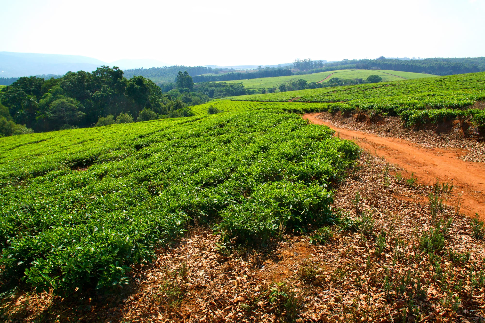
Rows of bright green tea bushes on rolling ground beside a red earth track, with wooded hills on the horizon

Blantyre & the Southern Region, Malawi

Mulanje

Tea bushes on an estate in the Mulanje tea country at the foot of the massif. (David Davies from Birmingham, UK / Wikimedia Commons · CC BY-SA 2.0)

A small trading town in Malawi's far south, set among tea estates at the foot of the Mulanje massif, the inselberg that rises abruptly from the plain to Sapitwa peak at 3,002 metres, the highest point in Malawi. The town is the district centre and the usual base for walks and climbs on the mountain, close to the Mozambican border.

Neighbourhoods

  • Mulanje boma and the market
    • Local life
    • Markets
    • Transport

    The district town on the main road, a strip of shops, banks, a market and the minibus stage where the roads to Blantyre, Phalombe and the border meet. This is where supplies, money and transport are arranged, and where most of the town's few guesthouses stand.

    Open in Maps
  • Likhubula
    • Walks and climbs
    • Waterfalls
    • Quiet

    A village at the mountain's foot a short drive from the town, at the forestry station where guides and porters are registered and most walks up the massif begin. Streams, pools and a cool, wooded setting under the rock faces make it quieter and greener than the boma.

    Open in Maps
  • The tea estates
    • Scenery
    • Quiet and residential
    • Drives

    The belt of estate land spreading west from the town towards Thyolo, with bright green bushes, shade trees, factory chimneys and estate housing. Narrow roads cut through the plantations, and the mountain stands over all of it.

    Open in Maps

Things to do

The mountain

  • Mount Mulanjeattraction

    The massif rising sheer from the surrounding plains to Sapitwa at 3,002 metres, the highest point in Malawi, with rolling plateau grassland between the peaks, deep forested ravines and stands of the endemic Mulanje cedar.

    Open in Maps
  • Mulanje Mountain Forest Reservepark

    The protected forest covering the massif and its lower slopes, with a network of paths between simple mountain huts and plantations of pine and cedar on the approaches.

    Open in Maps
  • Likhubula forest stationattraction

    The forestry post at the mountain's foot where guides and porters are registered and hut bookings are made, and the starting point for the most used routes onto the plateau.

    Open in Maps
  • Dziwe la Nkhalambaattraction

    A waterfall on the lower slopes of the massif, about an hour and a half's walk from the Likhubula forest station, with rock pools a few minutes from the station itself.

    Open in Maps

The town and the estates

  • Mulanje marketmarket

    The district market on the main road, selling maize flour, vegetables, dried fish, cloth and household goods, and busiest in the morning.

    Open in Maps
  • The tea estatesattraction

    Plantations spreading west towards Thyolo that have grown tea since the early twentieth century, with rows of bushes running to the foot of the mountain and factories processing the leaf.

    Open in Maps

Short trips from the town

  • Phalombeattraction

    The district town on the mountain's north-eastern side below the Fort Lister Gap, reached by a tarred road around the massif, with a different set of views up to the peaks.

    Open in Maps
  • Blantyreattraction

    The country's business capital, founded as a Scottish mission, with the brick Church of St Michael and All Angels, Mandala House and the region's main hospitals and shops.

    Open in Maps

Eat and drink

Long-standing places and food districts in Mulanje. Hours, ratings and directions come from your maps app, always current.

Mulanje classics

  • Nsima kitchens on the main roadrestaurant

    Small eating houses by the market and the minibus stage serving nsima with beans, greens, goat or dried fish such as usipa, the standard meal for travellers and traders.

    Open in Maps
  • Mulanje teacafe

    Black tea grown on the estates around the town and drunk strong with milk and sugar; some estates sell their leaf locally.

    Open in Maps

Markets and street food

  • Mulanje marketmarket

    Tomatoes, onions, bananas, groundnuts, cassava and dried fish, with mandazi and roasted maize sold from stalls at the roadside.

    Open in Maps

Experience Mulanje

History

Mulanje was made by tea. The mountain and the fertile, well-watered land at its foot drew European planters into the Shire Highlands in the 1890s, first for coffee, grown commercially from about 1895, and then, after Brazilian competition broke the coffee price, for tea, first planted commercially in the Shire Highlands in 1905; the estates around Mulanje and neighbouring Thyolo have been worked ever since. The town itself grew as the boma, the administrative and trading centre for the district that served them.

The estates needed labour, and they drew it largely from Lomwe families crossing the border from Portuguese Mozambique in large numbers in the colonial period, many of them settling as tenants on estate land under the thangata system, which required labour in exchange for the right to farm a plot. The system's harshness was among the grievances behind John Chilembwe's rising in 1915, centred on the estates a little to the west, and it shaped land politics in the district long after independence in 1964.

The massif above the town has its own history of use: forestry on the lower slopes, and the cutting of Mulanje cedar, the national tree, which grows nowhere else and has been reduced by logging and fire to scattered stands under a replanting programme. In March 2023 Cyclone Freddy brought extreme rain to the south of Malawi and killed more than a thousand people in the country; Mulanje district, along with neighbouring Phalombe, Blantyre, Chikwawa and Nsanje, was among the badly affected, with landslides and flooding off the mountain destroying homes, roads and fields.

Culture & Customs

The district is predominantly Lomwe, and much of Malawi's Lomwe identity is rooted here and in Phalombe and Thyolo — a community descended largely from nineteenth-century migration from Mozambique into the estate country, with its own language, Malawian Lomwe, still spoken by some tens of thousands of people in the south-east. Chichewa is the everyday language of the market and the school.

Christianity dominates, with Catholic, Presbyterian and a wide range of Pentecostal congregations, and church choirs are a serious local pastime. Beliefs about the mountain sit alongside them: Sapitwa, the highest peak, carries local stories and taboos, and guides will usually explain the customs expected on the mountain before a climb, which costs nothing to follow.

The other constant is the estate. Tea picking is the district's wage work, done by hand, mostly by women, in long lines across the bushes, and the estate calendar, the factory hooter and the walk to the fields shape daily life for thousands of households. Guiding and portering for walkers on the massif, which has been climbed by visitors since Sapitwa was first reached in 1894, give a smaller number of men seasonal work of their own.

Daily Life

Mulanje town is small, but the district around it holds more than 400,000 people and is one of the most densely settled parts of Malawi, and the town works as its market and service centre rather than as a city in its own right. The boma holds banks, a hospital, schools, district offices and the transport stage; most people live in villages on the plain and the lower slopes.

Work is tea, smallholder farming and trade. The estates employ pickers and factory staff; families grow maize, cassava, beans and bananas on small plots; and cross-border trade with Mozambique, a short distance down the road, moves goods and people in both directions. Guiding and portering on the mountain provide seasonal income for a few hundred men, and the tourism trade at Likhubula supports lodges and shops.

Population pressure shows: plots are small, firewood and charcoal cutting have stripped hillsides, and the loss of tree cover made the Cyclone Freddy landslides worse than they would otherwise have been. Recovery from that storm, the high cost of fertiliser and food, fuel shortages and unreliable power are the district's pressing problems. Days begin very early, with pickers in the fields and traders at the market before the heat builds, and finish soon after dark.

Food

Mulanje eats the Malawian staple: nsima, stiff maize porridge, taken by hand with ndiwo, a relish of beans, pigeon peas, pumpkin or cassava leaves, rape or cabbage, often cooked with groundnut flour. Meat is occasional — goat or chicken at a celebration — and the everyday protein is dried fish, usipa and other small species brought from the lakes and the Shire river and sold in the market.

The district grows more than maize. Bananas, cassava, sweet potato, mangoes, avocados and pigeon peas come off smallholdings on the mountain's lower slopes, and the cooler, wetter ground supports vegetables that struggle in the plains. Roadside sellers do roasted and boiled maize, sugar cane, groundnuts and mandazi, the small fried dough cakes eaten with tea in the morning.

Tea is the district's own product and the drink of the house, made strong with plenty of milk and sugar. Thobwa, the sweet, lightly fermented maize drink, is made in the villages; chibuku, the thick commercial maize and sorghum beer, is sold in cartons in the bottle stores; and bottled lager from the Carlsberg brewery in Blantyre comes up the road. On the mountain, food is whatever is carried up — porters cook nsima and relish at the huts.

Planning tools

Budget

Mulanje is cheap. Guesthouses in the town and simple lodges at Likhubula cost little, and a mountain trip is good value: guide and porter fees, hut fees and food are all modest, and they are the main expense of a visit. Transport from Blantyre is the other cost.

Daily Budget Midrange
USD 80–200 (lodge room, meals, a guide and porters on the mountain, a hired car)
Daily Budget Shoestring
USD 20–40 (guesthouse or hut, market food, minibuses)

Arrange guides, porters and hut bookings through the forestry office at Likhubula rather than with people offering their services on the road.

Best Time to Visit

May to October, the dry season, gives the most settled weather for walking, with clear mornings and cold nights high on the plateau. September and October are hot at the foot of the mountain. The rains from November to April bring cloud, slippery rock and rivers that rise fast, and paths can become dangerous.

Suggested Number of Days

A day or two is enough for the town, the estates and a walk at the foot of the mountain. Three to five allow a proper traverse with nights in the huts. Mist and rain routinely delay plans, so a spare day is worth keeping.

First Visit
1–2 days
With Surroundings
3–5 days

Transportation

Minibuses and shared pick-ups run along the Blantyre road and around the massif towards Phalombe, and bicycle taxis cover short distances in and around the town. Likhubula is a few kilometres off the main road and is reached by taxi, bicycle or a lodge vehicle. On the mountain there is no transport at all: everything is on foot.

Fix the fare before taking a bicycle taxi or a minibus seat, and allow for slow, crowded journeys on the roads around the mountain.

Airport & Station Connections

The town is about 70 kilometres from Blantyre by tarred road, roughly an hour and a half by car and longer by minibus; Chileka at Blantyre is the nearest airport. The Mozambican border lies a short distance further east along the same road. Most visitors arrive by minibus from Blantyre or by hired car, then continue to Likhubula for the mountain.

Walkability

The town itself is small enough to cross on foot in fifteen minutes, and the market, shops and transport stage are all together on the main road. Beyond it distances open out: Likhubula is several kilometres away, the estates spread for many more, and the mountain paths are serious walking that needs boots, water and a guide.

Safety

The town is quiet, with the usual risks of petty theft around the market and the transport stage. The mountain is the real hazard: weather changes fast, mist can close in within minutes, rivers rise dangerously in the rains and people have died from exposure and from falls on the rock. The district was badly hit by Cyclone Freddy in 2023, and landslides and flooding remain a wet-season risk.

Walk with a guide on Zomba and Mulanje, take taxis after dark in Blantyre, and follow flood warnings between January and March. Check current official travel advice before travelling.

Climate

Warm at the foot of the mountain and much colder on the plateau above, where frost is possible in the dry season. Rain falls in one long season, and the massif catches a great deal more of it than the plain around.

Summer
hot and wet, December–February — days around 29°C in the town, with heavy rain, cloud on the mountain and swollen rivers
Winter
dry and mild, June–August — days in the mid-20s °C below and cold nights on the plateau, near or below freezing at the huts

Local Customs

This is a rural, largely Lomwe and Christian district, and dress is conservative: knees and shoulders covered away from lodges. Greetings are expected before any request, and elders are greeted first. Guides and porters are working to set rates agreed at the forestry office, and bargaining them down is poorly regarded. Ask before photographing people or estate workers.

Tipping guides and porters at the end of a climb is customary and appreciated. Alcohol is sold in bars and bottle stores but is out of place in villages and on the mountain.

Common Payment Methods

The currency is the Malawian kwacha. There are banks and cash machines in the town, but they can be out of service or out of notes, and nothing on the mountain takes cards. Guide, porter and hut fees are paid in cash, so draw enough in the town or in Blantyre before setting off.