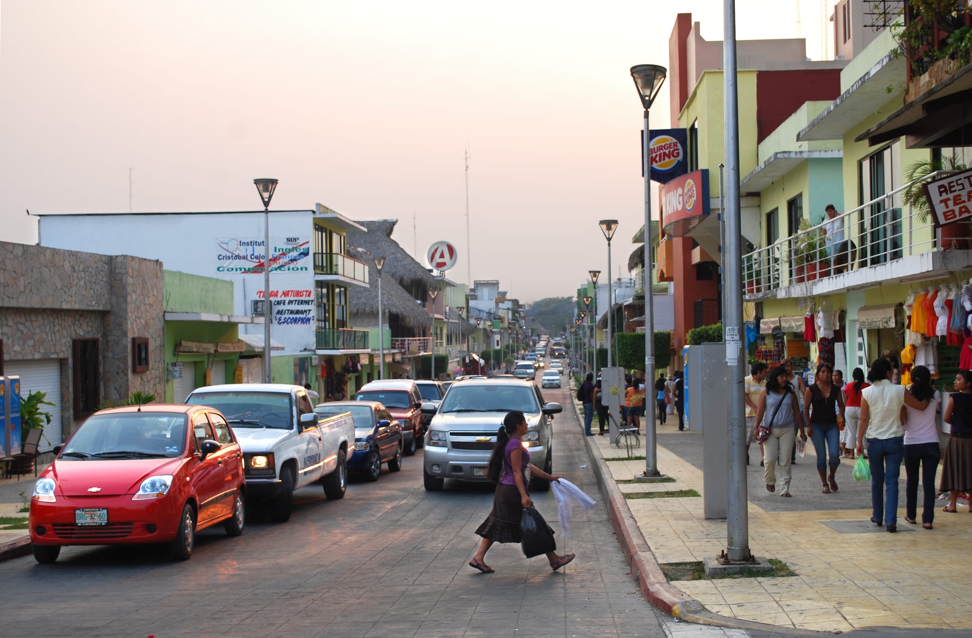
Avenida Benito Juárez in Palenque at dusk, with parked cars, shopfronts, balconies and people on the pavement

Chiapas, Mexico

Palenque

Avenida Benito Juárez, a street in the centre of the town of Palenque. (AlejandroLinaresGarcia / Wikimedia Commons · CC BY-SA 4.0)

A lowland town in northern Chiapas, founded by a friar in 1567 to gather Ch'ol Maya families on the edge of the rainforest, a few kilometres from the Classic Maya city whose name it shares. Once a quiet farming centre, it now lives largely on visitors to the ruins and the waterfalls, and is the western end of the Tren Maya.

Neighbourhoods

  • Town centre
    • First-time visitors
    • Nightlife
    • Close to public transport

    The grid of streets around the Parque Central and the parish church of Santo Domingo, with Avenida Benito Juárez running out towards the bus station. Bars and restaurants around the park make it the place to go out in the evening, and minibuses to the ruins leave from here.

    Open in Maps
  • La Cañada
    • Quiet and residential
    • Close to the bus station

    A district of hotels and restaurants near the main bus terminal, convenient for early departures.

    Open in Maps
  • The road to the ruins and El Panchán
    • Rainforest stays
    • Close to the ruins

    Hotels, cabins and campsites line the road from town to the national park. El Panchán, a cluster of cabañas and a restaurant with live music in the forest about four and a half kilometres along it, has long been popular with backpackers; it has little or no mobile coverage.

    Open in Maps

Things to do

The ruins and the forest

  • Palenque archaeological sitelandmark

    A Classic Maya city at the foot of the hills, smaller than Tikal or Chichén Itzá but known for some of the finest architecture and carving the Maya produced; with its national park it is a UNESCO World Heritage Site.

    Open in Maps
  • Temple of the Inscriptionslandmark

    The funerary pyramid of the ruler Pakal, whose tomb was found inside in 1952, named for the long hieroglyphic texts in its temple.

    Open in Maps
  • The Palacelandmark

    The largest and most complex building at the site, enlarged many times in the 7th century, with its four-storey tower.

    Open in Maps
  • Palenque site museummuseum

    The museum beside the ruins, founded in 1958 and enlarged in 1995, on the city's place in the Maya world and the history of its excavation.

    Open in Maps
  • Palenque National Parkpark

    The rainforest around the ruins, protected since 1981, with trails past streams and small waterfalls, howler monkeys and around 300 recorded bird species.

    Open in Maps

In and around town

  • Parque Centralpark

    The town's main square, the meeting point for evenings out, with the parish church of Santo Domingo, where the town's annual passion play begins.

    Open in Maps
  • Ecoparque Aluxespark

    A wildlife rescue and conservation centre near the town, with natural enclosures for jaguars, ocelots, macaws, spider monkeys and turtles, and a programme to release macaws into the national park.

    Open in Maps

Short trips from the town

  • Misol Hápark

    A single 35-metre waterfall dropping into a round pool in the forest, with a cave behind the cascade, about 20 kilometres from Palenque on the road towards San Cristóbal.

    Open in Maps
  • Agua Azulpark

    A long series of turquoise cascades on the Xanil river, whose mineral-rich water coats rocks and fallen trees in limestone, protected since 2000.

    Open in Maps
  • Roberto Barrios waterfallspark

    A quieter, more remote set of falls in the countryside around Palenque, known for its swimming pools and small crowds.

    Open in Maps

Seasonal events

  • Holy WeekMarch or April

    A major holiday period in Mexico, when large numbers of visitors arrive in Palenque and extra protection is put in place at the ruins.

  • Spring equinoxMarch

    Palenque is one of the Mexican sites, with Teotihuacan and Chichén Itzá, that draws large crowds for the spring equinox.

  • Festival Mundo MayaApril

    A festival of the culture, music, crafts, food and dress of the Maya peoples, with participants from Tabasco, Yucatán and Campeche.

Eat and drink

Long-standing places and food districts in Palenque. Hours, ratings and directions come from your maps app, always current.

Palenque classics

  • Parque Central bars and restaurantsneighborhood

    The bars and restaurants around the main square, the town's liveliest place in the evening, from michelada bars to places with live music.

    Open in Maps
  • El Panchánrestaurant

    The restaurant at the heart of the cabaña settlement on the road to the ruins, known for its stone-oven pizza and live music.

    Open in Maps

Food districts

  • La Cañadaneighborhood

    A cluster of restaurants near the main bus terminal.

    Open in Maps

Experience Palenque

History

The name Palenque is Spanish for a fence of wooden stakes, a translation of the Ch'ol word Otulún, "fortified place". The friar Pedro Lorenzo founded the town in 1567 to gather Ch'ol families scattered through the forest, and in 1573 it received three bells as a sign of its founding; one still hangs in the parish church. The Spanish did not know about the ancient city a few kilometres away, which the town named almost two centuries before the ruins were found. Father Antonio Solís came upon them in 1740, and from then on the ruins shaped the town's fortunes.

From 1768 it belonged to the alcaldía mayor of Ciudad Real, today's San Cristóbal, and it was declared a town in 1813. A road to Bachajón was built in 1821, and in the 1880s a railway linked the area with the Gulf of Mexico through the Pakalná station. An airfield opened in 1931, and in 1972 the state government declared Palenque a city. Excavations at the ruins from 1949 to 1952 led to the discovery of Pakal's tomb, the site museum opened in 1958, and the national park around the ruins was created in 1981.

Tourism has grown ever since. The main road was paved in 1990, a new airport opened in 2014, and in 2015 the town was named a Pueblo Mágico. On 1 January 2024 the Tren Maya opened its Palenque station, on the grounds of the old airport, as the western end of a railway around the Yucatán Peninsula.

Culture & Customs

Palenque sits in the Ch'ol Maya country of northern Chiapas, and about 40 per cent of the municipality's people are Indigenous, most of them Ch'ol, and just over a fifth of the Indigenous residents do not speak Spanish. Religion is more mixed than in the state as a whole: around half the population is Catholic, with a large Protestant and Evangelical minority and many who profess no religion.

The main religious feasts are those of Saint Dominic, the patron of the parish, and Francis of Assisi, and each year the town stages a passion play in which a young man of the area is chosen to play Jesus, following the Stations of the Cross from the church of Santo Domingo. In April the municipality holds the Festival Mundo Maya, on the culture, folklore, crafts, food and dress of the Indigenous peoples descended from the Maya, with participants from Tabasco, Yucatán, Campeche and parts of Puebla.

The ruins dominate the town's identity and its calendar, with crowds arriving for Holy Week and the spring equinox. The forest is close: howler monkeys, driven by deforestation, sometimes wander into town in search of food.

Daily Life

The municipality had about 132,000 people at the 2020 census; the town itself had about 43,000 in 2010, and it is the only urban area in a municipality of several hundred rural communities. Palenque is described as the poorest major city in Chiapas, and much of the surrounding population is economically marginalised. Housing reflects it: in 2005 more than a third of the municipality's homes had dirt floors, and only about three-quarters had running water. The population has grown fast, at more than 3 per cent a year around 2000.

About half the municipality's working people are in farming and livestock, many of them unpaid, and about a third in commerce and services, including tourism. The municipality has some 67 hotels with nearly 2,000 rooms, almost all of them in the town, and many families depend on the flow of visitors to the ruins.

Deforestation has had dramatic effects on the local environment, and many forest areas in the municipality have been devastated, though rainforest still surrounds the town.

Food

Palenque eats the food of lowland Chiapas. Pozol, a cold drink of ground maize, often mixed with cacao, is drunk through the day in the lowlands, and tamales come in many forms, among them tamales de chipilín, flavoured with a local green herb. Cacao grows in the lowlands, and chocolate drinks such as tascalate, made with ground maize, cacao and achiote, are common across the state. Chiapas dishes such as cochito horneado, pork baked in a spiced adobo of chillies and vinegar, and queso de bola, the round cheese made in nearby Ocosingo, appear on menus here as across the state.

The town's eating is informal, in markets, comedores and the restaurants of the centre. The streets around the Parque Central fill in the evening with bars serving beer and micheladas — beer mixed with a spicy chilli blend.

Near the ruins, the restaurants of El Panchán and the hotels along the road cater largely to travellers, with pizza, vegetarian dishes and international food alongside Mexican plates, often with live music in the evening.

Planning tools

Budget

Palenque is inexpensive. Hostels, guesthouses and cabins near the ruins cost little, and town restaurants and market stalls are cheap. The main costs are the entry charges to the ruins and the national park, which are collected separately, and the tours to the waterfalls, which are good value and the usual way to reach them.

Daily Budget Midrange
USD 75–150 (hotel with air-conditioning, restaurants, guided visits and a waterfall tour)
Daily Budget Shoestring
USD 30–50 (hostel or cabaña, market food, minibuses to the ruins)

Carry pesos in small notes: the ruins, the park and the waterfalls each charge separately, and some charges are cash only.

Best Time to Visit

November to April is the drier season. Easter week and the spring equinox bring large crowds. Rain can fall at any time of year but is heaviest in summer.

Suggested Number of Days

Most visitors stay two nights, enough for the ruins and the national park. Allow three or four days in all to include the waterfalls, and longer to reach the jungle ruins near the Guatemalan border.

First Visit
2 days
With Surroundings
3–4 days

Transportation

The town is small enough to walk. Minibuses run between the town and the ruins, about seven kilometres away, every 10 to 15 minutes during the day, and stop along the road past the hotels and El Panchán. Taxis are available, and tour agencies in town run trips to the waterfalls and the jungle ruins.

Visit the waterfalls on an organised tour or a shuttle rather than alone: they are in rural areas, and the Ocosingo road past Agua Azul is known for blockades and roadside charges.

Airport & Station Connections

Palenque International Airport, opened in 2014, has had flights from Mexico City since Mexicana began a service in January 2024; Villahermosa's airport is about two hours away by road. The Tren Maya's Palenque station, opened on 1 January 2024 on the site of the old airport, is the line's western terminus, with trains around the Yucatán Peninsula. First-class buses use the ADO terminal in town, with services from San Cristóbal, Villahermosa, Mérida, Campeche and Mexico City; shuttles to San Cristóbal take the shorter road past the waterfalls.

Walkability

The centre is compact and flat, and the main street, the park and the bus station are all within walking distance. The heat and humidity make long walks tiring by midday. The ruins are too far to walk along the main road, so most people take a minibus.

Safety

Safety varies enormously by state and even neighbourhood. San Cristóbal, Palenque and the main tourist routes are visited without trouble by most travellers, but Chiapas has serious problems away from them: rival organised-crime groups have fought for territory near the Guatemalan border since around 2021, and road blockades, land disputes and robbery on rural roads are common. The town centre is a pleasant place to walk in the evening; the waterfalls lie in rural areas outside the town.

Travel by day, use tours or shuttles for the waterfalls, check locally before taking the Ocosingo road, and avoid the border areas. Check current official travel advice before travelling.

Climate

Hot and humid all year, at only about 60 metres above sea level, with tropical rainforest around the town. Rain falls in every month, with the heaviest downpours in summer; the ruins average around 26°C.

Summer
hot, humid and wet, with heavy downpours; the regional figure for the lowlands is 30–35°C
Winter
drier and slightly cooler; the regional figure for the lowlands is 20–30°C

Local Customs

About two-fifths of the municipality's people are Indigenous, most of them Ch'ol Maya, and Protestant and Evangelical churches are more common here than in the state as a whole.

Ask before photographing people, especially in Indigenous communities.

Common Payment Methods

The currency is the Mexican peso. There are ATMs in town, and cards are accepted in larger hotels and some restaurants, but entry charges, minibuses, markets and waterfall fees are usually paid in cash.