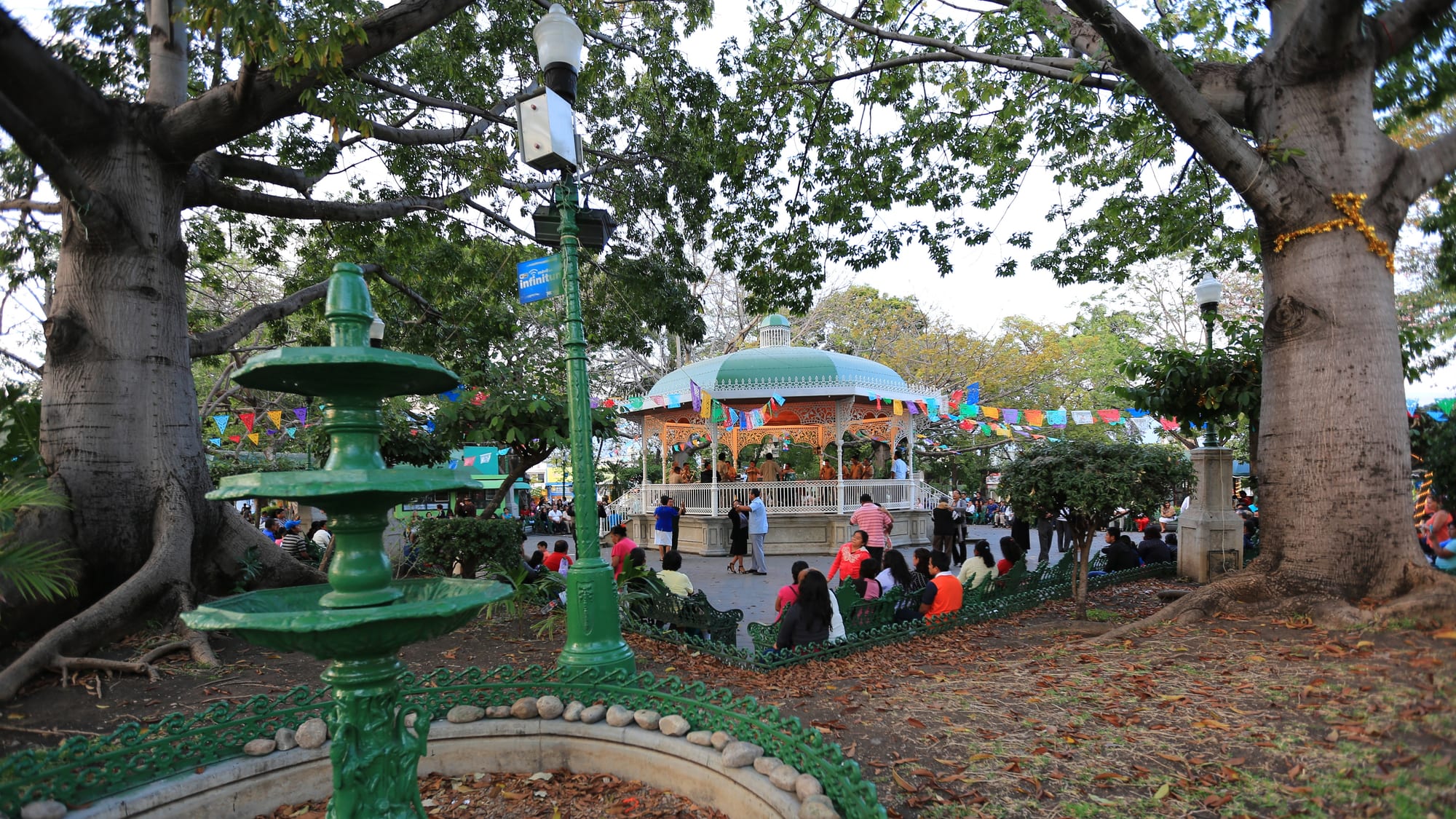
A green iron fountain and large trees framing the domed bandstand of the Parque de la Marimba, with people on benches under paper bunting

Chiapas, Mexico

Tuxtla Gutiérrez

The bandstand of the Parque de la Marimba in Tuxtla Gutiérrez, where marimba bands play in the evenings. (panza.rayada / Wikimedia Commons · CC BY-SA 3.0)

The capital and largest city of Chiapas, in a hot valley at about 600 metres beside the Sumidero Canyon. A Zoque village gathered around a Dominican church in the 16th century, it took over as state capital in 1892 and grew fast from the 1970s into a modern government and business city, now best known to travellers as the state's air and bus gateway.

Neighbourhoods

  • Centro
    • First-time visitors
    • Close to public transport
    • Business

    The business heart of the city around the Plaza Cívica, with the Cathedral of San Marcos, the state and municipal government buildings and Avenida Central, the main avenue running west to east. Cheap food stalls around the central square stay open late.

    Open in Maps
  • Parque de la Marimba and the west centre
    • Evenings out
    • Music
    • Best for food

    Eight blocks west of the main square, the tree-shaded Parque de la Marimba is the city's favourite evening meeting place, with marimba concerts, older couples dancing and the marimba museum beside it, surrounded by restaurants and cafés.

    Open in Maps
  • Parque Madero and the museum corridor
    • Museums
    • Parks

    A green area about six blocks from the Plaza Cívica, crossed by the Calzada de los Hombres Ilustres, along which stand the regional museum, the palaeontology museum and the Faustino Miranda Botanical Garden beside the Sabinal river.

    Open in Maps
  • The west side
    • Quiet and residential
    • Shopping

    The most affluent part of the city, with suburban neighbourhoods and modern shopping centres, a taxi ride from the centre.

    Open in Maps
  • Copoya
    • Viewpoints
    • Local traditions

    A small town on the Copoya plateau above the city, about 15 minutes by road from the centre, home to the giant Cristo de Chiapas cross and to the Virgin statues that are carried down to Tuxtla each year in a Zoque procession.

    Open in Maps

Things to do

Landmarks

  • Cathedral of San Marcoslandmark

    The city's main church on the Plaza Cívica, founded as a Dominican parish in the 16th century and remodelled in white in the 1980s, with the only colonial apse left in Chiapas and 48 bells that ring each hour as figures of the Apostles parade on the tower.

    Open in Maps
  • Parque de la Marimbapark

    A park with a central kiosk, opened in 1993 and named after the state's most characteristic instrument, where marimba bands play in the evening and couples dance.

    Open in Maps
  • Cristo de Chiapasviewpoint

    A 62-metre monumental cross completed in 2011 on the Copoya plateau, with the silhouette of Christ inside it and wide views over the city.

    Open in Maps

Museums

  • Regional Museum of Anthropology and Historymuseum

    The city's largest museum and one of the most important of its kind in Mexico, with one hall on the state's Mesoamerican archaeology and another on its history since the Spanish conquest.

    Open in Maps
  • Museo de Paleontología Eliseo Palacios Aguileramuseum

    A museum of more than 200 fossils from Chiapas, opened in 2002 next to the regional museum, built around a reconstructed giant ground sloth, with a display of amber containing insects and spiders.

    Open in Maps
  • Museo de la Marimbamuseum

    A museum of the marimba beside the park of the same name.

    Open in Maps
  • Museo del Café de Chiapasmuseum

    A museum of the history of coffee growing in the state, with tastings and exhibitions.

    Open in Maps
  • Casa de Artesaníasmuseum

    The state crafts institute in a large purple building on the main boulevard, selling Chiapas textiles, ceramics, toys and amber, with an ethnographic museum of village life and dress.

    Open in Maps

Parks and nature

  • ZooMATpark

    A zoo in the El Zapotal reserve on the edge of the city that shows only the wildlife of Chiapas — jaguars, tapirs, macaws, monkeys and quetzals — in grounds designed to respect the natural terrain; it was the first to breed the quetzal in captivity.

    Open in Maps
  • Faustino Miranda Botanical Gardenpark

    A four-hectare botanical garden along the Sabinal river in Parque Madero, with a botanical museum whose oldest exhibition is of the state's timber trees.

    Open in Maps
  • Sumidero Canyon viewpointsviewpoint

    The road from the city's northern edge into the national park leads to a chain of viewpoints high above the gorge, whose walls rise up to 1,000 metres above the Grijalva.

    Open in Maps

Markets

  • Mercado de los Ancianosmarket

    A large traditional market south-east of the centre, selling flowers, meat, seafood, clothes and household goods, with an open-air eating area cooking from the market's produce.

    Open in Maps

Short trips from the city

  • Chiapa de Corzoattraction

    A small colonial town on the Grijalva about 12 kilometres east, occupied since at least 1400 BCE, from which the boats into the Sumidero Canyon leave and where the Fiesta Grande is held each January.

    Open in Maps
  • Boat trip through the Sumidero Canyonpark

    Boats from Chiapa de Corzo run up the Grijalva between the canyon's vertical walls towards the Chicoasén Dam, the way most visitors see the gorge.

    Open in Maps

Seasonal events

  • Bajada de la Virgen de Copoyalate January

    Part of the Zoque Carnival: statues of the Virgin are carried on foot from the church in Copoya down to the city, where they stay for two months before returning to the plateau.

  • Fiesta Grande de Chiapa de CorzoJanuary

    In the neighbouring town, weeks of celebrations with the masked parachicos dancers, a festival on UNESCO's intangible heritage list.

  • Feria de San Marcoslate April

    The patron saint's fair in the city centre, with offerings, castillos — fireworks mounted on frames — and four days of pilgrimages.

  • Feria Chiapaslate November to early December

    The state fair, held since 1980, with bullfights, horse racing, cockfights and exhibitions of Chiapas crafts, manufactures and farm produce.

Eat and drink

Long-standing places and food districts in Tuxtla Gutiérrez. Hours, ratings and directions come from your maps app, always current.

Tuxtla classics

  • Mercado de los Ancianosmarket

    The big market's open-air café, under a large red tent, serves dishes cooked from the stalls' produce.

    Open in Maps
  • Food stalls around the Parque Centralneighborhood

    Cheap snack and food stalls around the central square that stay open late.

    Open in Maps

Cafés and evenings

  • Parque de la Marimbaneighborhood

    The cafés and restaurants around the park, busiest in the evening when the marimba concerts begin.

    Open in Maps

Experience Tuxtla Gutiérrez

History

The Zoque were the first to settle the valley, which they called Coyatoc, "land or house of rabbits"; the Aztecs, who pushed into the area between 1486 and 1505, translated the name as Tuchtlan. After the Spanish subdued the Chiapa people in 1528, Dominican friars gathered the scattered Zoque into church-centred villages, founding a church of San Marcos for one of them in 1560. The town has no official founding date. San Marcos Tuxtla is first recorded in 1748, and in 1813 the Spanish king recognised it as a villa of about 5,000 people, three-quarters of them Zoque.

Tuxtla declared independence in 1821 and, with the rest of Chiapas, joined Mexico by popular vote on 14 September 1824. In 1848 it took the name Tuxtla Gutiérrez in honour of Joaquín Miguel Gutiérrez, a governor who had championed annexation to Mexico. Through the 19th century the state government moved back and forth between Liberal Tuxtla and Conservative San Cristóbal, and on 11 August 1892 Tuxtla became the capital for good. During the Revolution, landholders opposed to land redistribution burned the state government building and its archives in 1915.

The diocese of Tuxtla was created in 1965, raising San Marcos to a cathedral, and it became an archdiocese in 2010. From the 1970s the city grew faster than almost anywhere in Mexico, absorbing the neighbouring municipality of Terán in 1973. The Zapatista uprising touched it too: as many as 10,000 sympathisers marched here in 1998 to press for the San Andrés Accords, and unrest in the countryside brought many Indigenous families to the city.

Culture & Customs

Tuxtla is a mestizo city with a significant Zoque population, and its biggest traditions are Zoque. Each January the statues of the Virgin are carried down from the church at Copoya to spend two months in the valley before returning, and the city's other feasts — San Roque, San Jacinto, San Pascualito, San Francisco, Santo Domingo and the Virgin of Guadalupe — keep the old barrios' calendars. The Feria de San Marcos fills the centre each April with offerings and castillos, while the Feria Chiapas, first held in 1980, brings bullfights, horse races and exhibitions of the state's produce.

Music means the marimba. Bands play every evening in the Parque de la Marimba, opened in 1993, where older couples come to dance, and there is a museum devoted to the instrument beside it. The cathedral's tower has its own performance: 48 bells ring out each hour as figures of the Apostles process around it.

The city is also a starting point for sport: the Carrera Panamericana road race begins here, and the city was home to the Jaguares football club until the franchise dissolved. The city is not a major tourist attraction, and many travellers simply pass through its airport and bus station.

Daily Life

About 579,000 people lived in the city at the 2020 census, and some 848,000 in the metropolitan area that joins it to Chiapa de Corzo. The population is young and has grown quickly for five decades, with migrants arriving from rural Chiapas and from Veracruz, the State of Mexico and Mexico City. Rural migration since the 1990s has added Tzotzil, Tzeltal, Zapotec and Ch'ol speakers to the native Zoque.

Government at every level has been a main employer since the 1970s, and more than three-quarters of working people are in commerce and services. The municipality is the only one in Chiapas with a very low rate of economic marginalisation, but rapid growth has left services behind in many low-income areas, which make up about 40 per cent of the city, and thousands of illegal connections drain the water system.

The wealthier districts and shopping centres are mostly on the west side, downtown is mainly for business, and the poorest areas spread across the north and east. Daily life is shaped by the heat: most homes and offices use fans rather than air-conditioning, and many businesses close from early afternoon until about 5 pm. The polluted Sabinal river and pressure on the green reserves around the city are long-running concerns.

Food

Tuxtla's cooking reflects the rest of the state, with a few dishes of its own. Pictes are sweet corn tamales; chispota is beef with chickpeas and cabbage; niguijuti is pork in mole; cochito is pork in an adobo sauce; and chanfaina is lamb offal cooked with rice. Sopa de pan, bread with broth and vegetables, is another local dish.

Grilled meat is a local passion: carnes parrilladas are platters of mixed grilled meats, and carne molida tártara is spicy ground meat "cooked" in lime juice with onion, tomato and coriander, usually eaten on tostadas. In the rainy season people collect nucú, an edible ant that comes out at night, rich in protein.

Local drinks include pozol, a maize and cacao drink typical of Chiapas, taxcalate, agua de chía, tashiagual and pinole. Coffee from the state's highlands is served across the city, and the coffee museum offers tastings. The Mercado de los Ancianos and the stalls around the central square are the places for everyday food.

Planning tools

Budget

Tuxtla has around 70 hotels, many aimed at business travellers, and prices in the city are low. Market food and street stalls cost little. The road to the canyon viewpoints passes a tollbooth at the park entrance, and many people see both the rim and the boat trip on a combined tour from a travel agency, which can work out cheaper than a taxi.

Daily Budget Midrange
USD 75–150 (business hotel, restaurants, taxis and a canyon tour)
Daily Budget Shoestring
USD 30–50 (hostel or budget hotel, market food, colectivos and city buses)

Hotel occupancy rises sharply at Holy Week, when much of Mexico travels, so expect fuller hotels then.

Best Time to Visit

The dry season from about October to April is the most comfortable, and the city's festivals fall in January, April and late November. The rainy season from May to September is hot and humid, and tropical storms occasionally reach the valley.

Suggested Number of Days

Many travellers pass straight through on the way to the highlands. One or two days are enough for the city itself; allow two or three with the canyon and the towns nearby.

First Visit
1–2 days
With Surroundings
2–3 days

Transportation

Tuxtla is a car city of wide, busy avenues full of cars, taxis and buses. Taxis are widely used, colectivo vans and city buses cover most routes, and a faster bus line, the conejobus, has run along Avenida Central. The canyon viewpoints are many kilometres up a road through the national park and are visited by car, taxi or tour.

Businesses often close from about 2 pm until 4:30 or 5 pm, in the hottest part of the day.

Airport & Station Connections

Tuxtla Gutiérrez International Airport (Ángel Albino Corzo), opened in 2006, serves the city and much of the state, including San Cristóbal and Comitán, with flights above all to Mexico City and other Mexican cities. Taxis are sold by ticket inside the terminal, and buses run to the city's first-class bus station and to San Cristóbal. First-class buses connect the city with Mexico City, Puebla, Oaxaca, Villahermosa, Mérida and Cancún, and a toll motorway reaches San Cristóbal in under an hour.

Walkability

The centre is flat and walkable between the Plaza Cívica, the cathedral and the Parque de la Marimba, and Parque Madero's museums are close together. Beyond the centre the city is spread out along wide avenues, and the heat in the middle of the day makes long walks tiring.

Safety

Safety varies enormously by state and even neighbourhood. San Cristóbal, Palenque and the main tourist routes are visited without trouble by most travellers, but Chiapas has serious problems away from them: rival organised-crime groups have fought for territory near the Guatemalan border since around 2021, and road blockades and robbery on rural roads are common. In 2011 Tuxtla was the first city in Mexico certified as a "safe city" for its low crime rate. The highway to San Cristóbal is often blocked by protesters.

Allow extra time for the road to the airport from San Cristóbal and ask whether any blockades are expected, travel by day, and use official airport taxis. Check current official travel advice before travelling.

Climate

A tropical wet and dry climate at about 600 metres: hot and fairly humid all year, with little change apart from the amount of rain, which falls mostly in summer. The annual mean temperature at the zoo is about 25°C.

Summer
hot, humid and rainy; the regional figure for the lowlands is 30–35°C
Winter
dry and warm; the regional figure for the lowlands is 20–30°C

Local Customs

Tuxtla is a mestizo city with a long Zoque heritage, kept alive in the Copoya procession and the patron saints' fairs. Most homes and offices rely on fans rather than air-conditioning, and many shops close for the hottest hours of the afternoon. The marimba is a point of local pride, and an evening at the Parque de la Marimba is the city's classic outing.

Expect fireworks, castillos and crowds in the centre during the patron saint's fair in April.

Common Payment Methods

The currency is the Mexican peso. ATMs and card payment are common in the centre, shopping centres and hotels, while markets, colectivos and food stalls take cash.