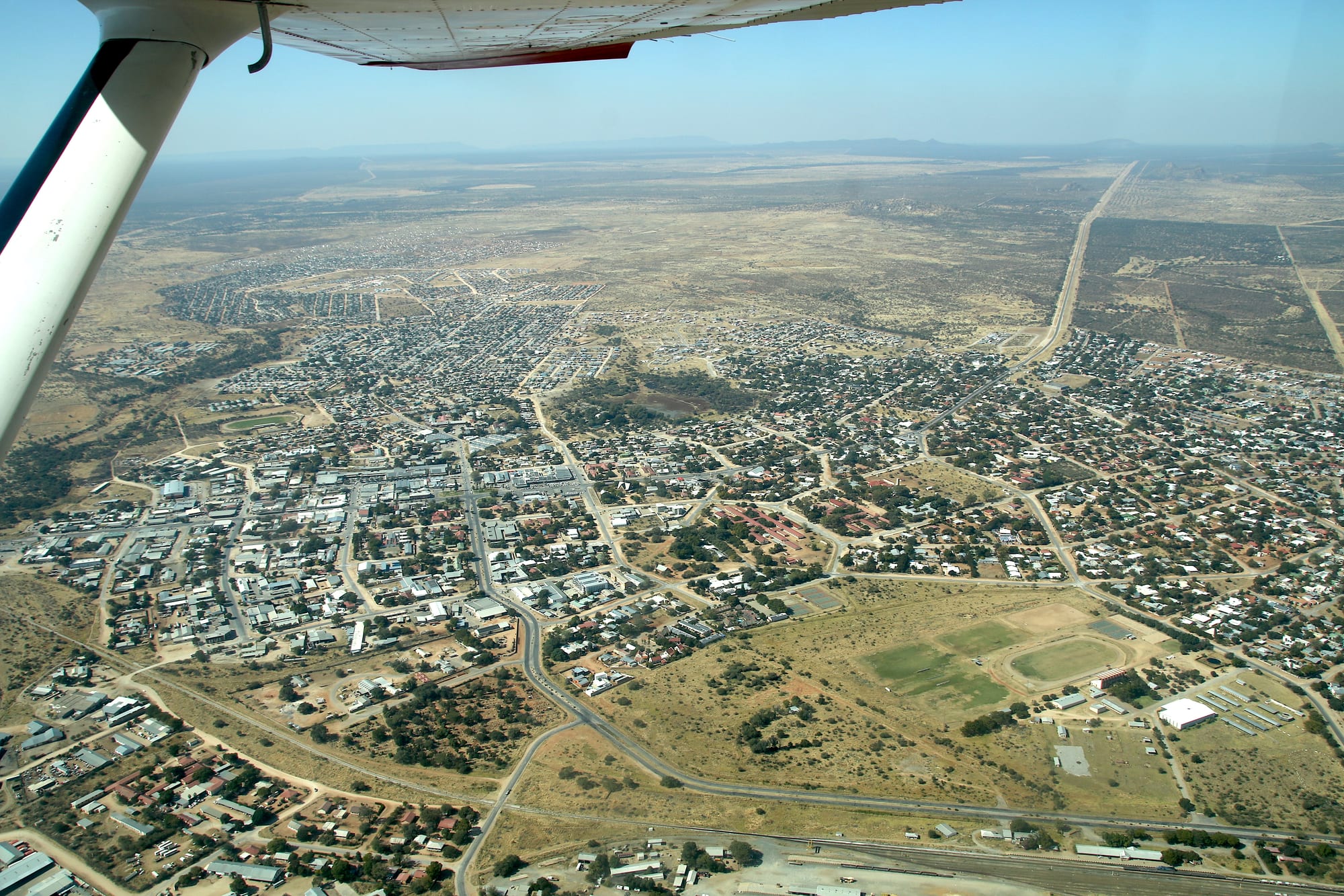
An aerial view of a low town of tin roofs and trees spreading across dry bush towards distant hills

Windhoek & Central Namibia, Namibia

Otjiwarongo

Otjiwarongo from the air, with its centre, sports ground and railway line set in the thornbush of the central highlands. (Hp.Baumeler / Wikimedia Commons · CC BY-SA 4.0)

A cattle-farming town on the B1 about 250 kilometres north of Windhoek, capital of the Otjozondjupa Region and the crossroads where the roads to Etosha, the Waterberg and the northwest divide. Its Otjiherero name is usually translated as the beautiful place of the fat cattle, and it grew around the railway that reached it in 1906. Today it is best known as a base for cheetah and leopard conservation projects in the bush around it.

Neighbourhoods

  • The town centre
    • First-time visitors
    • Practicalities
    • Close to the main road

    A few straight streets between the B1 and the railway, holding the supermarkets, banks, fuel stations, workshops and most of the guesthouses. It is the stocking-up point for travellers heading to Etosha or the Waterberg, and it is busy by day and quiet after dark.

    Open in Maps
  • Orwetoveni
    • Local life
    • Markets

    The township on the northern side of the town, where most of Otjiwarongo's people live. Small shops, bars, churches and open-air meat grills line its main roads, and new housing keeps extending it outwards into the bush.

    Open in Maps
  • The guest-farm belt
    • Quiet and residential
    • Wildlife

    Beyond the last streets in every direction lie the fenced cattle and game farms that the town exists to serve. Many take guests for a night or two in farmhouse rooms or chalets, and the turnoffs are signposted from the main roads.

    Open in Maps

Things to do

In the town

  • The old steam locomotivelandmark

    Locomotive No. 41, a narrow-gauge steam engine brought from Germany to haul ore between Tsumeb and Swakopmund, stands preserved in front of the railway station in the centre of town.

    Open in Maps
  • Otjiwarongo crocodile ranchattraction

    A crocodile ranch on the edge of town, one of the few captive breeding programmes for the Nile crocodile registered with CITES, and open to visitors.

    Open in Maps
  • The Sunday market streetsmarket

    Stalls of vegetables, clothes, hardware and grilled meat set up along the main roads of Orwetoveni and near the centre, the town's everyday trading life.

    Open in Maps

Short trips from the town

  • Cheetah Conservation Fundattraction

    A research and education centre founded in 1990 by the biologist Laurie Marker, on farmland about 44 kilometres east of the town, working with farmers to reduce conflict with cheetahs, with a visitor centre, resident cheetahs and livestock guarding dogs.

    Open in Maps
  • Okonjimaattraction

    A nature reserve of about 200 square kilometres some 50 kilometres from Otjiwarongo, in the Omboroko Mountains, home of the AfriCat Foundation and its work with leopards, cheetahs and other large carnivores.

    Open in Maps
  • Waterberg Plateau Parkpark

    A sandstone plateau rising high above the plains about 68 kilometres south-east of the town, declared a nature reserve in 1972 and stocked with endangered species including black rhino, with walking trails, a rest camp and the site of the 1904 battle between German troops and the Herero.

    Open in Maps
  • Otaviattraction

    A small town north-east on the B1 in a belt of limestone hills and maize farms, at the junction of the roads to Tsumeb and to Grootfontein.

    Open in Maps

Eat and drink

Long-standing places and food districts in Otjiwarongo. Hours, ratings and directions come from your maps app, always current.

Eating in Otjiwarongo

  • The main street's steakhouses and cafésneighborhood

    Beef from the surrounding farms is the reason to eat here, usually a steak with chips or pap, alongside schnitzel, burgers and a bakery counter in the fuel-station cafés.

    Open in Maps
  • Kapana grills in Orwetovenimarket

    Strips of beef grilled over open fires, dipped in dry chilli and spice and eaten standing with fat cakes, the standard cheap meal in the township.

    Open in Maps
  • Butchers and biltong countersmarket

    Cattle country supermarkets and butcheries sell biltong, thin droëwors sausage and boerewors by weight — the usual road-trip supply for the drive north.

    Open in Maps

Experience Otjiwarongo

History

The Herero moved cattle across this part of the highlands long before there was a town, and the name Otjiwarongo, in Otjiherero, is usually translated as the beautiful place of the fat cattle — a reference to the grazing and water that made it worth stopping at. The area was caught up in the German colonial wars of 1904, when fighting between German troops and the Herero ended at the Waterberg to the south-east and the survivors were driven into the Omaheke sandveld.

The modern town dates from the railway. The narrow-gauge Otavi line, built by a mining company to carry copper ore from Tsumeb to the coast at Swakopmund, reached this point in 1906, and a settlement of station buildings, stores and workshops grew beside the track; a locomotive from the line still stands at the station. Under German and then South African rule the surrounding land was surveyed into large cattle farms, and Otjiwarongo became their service centre, with an abattoir, agricultural suppliers and a stock market.

Cattle still underpin the town, but two other things have reshaped it since independence in 1990. It became the capital of the Otjozondjupa Region and grew with the government offices, schools and clinics that came with the role; and the farmland around it turned into the centre of Namibian carnivore conservation, after the Cheetah Conservation Fund was founded nearby in 1990 and the neighbouring farm at Okonjima became the base of the AfriCat Foundation.

Culture & Customs

Otjiwarongo sits in the Herero heartland, and Herero identity is the strongest cultural thread in the town: Otjiherero is widely spoken, cattle are a measure of standing as much as of wealth, and the long Victorian-style dresses and horn-shaped headdresses that Herero women adopted from nineteenth-century missionaries and made their own are worn in the streets, at church and at funerals. The Herero calendar of commemorations, above all the August gathering at Okahandja and the remembrance of the events at the Waterberg, matters here.

It is also a mixed working town. Damara, Nama, Ovambo and San families, Afrikaans speakers, and a small German-Namibian farming community share it, and church life is a central social institution across all of them — Lutheran above all, with Catholic and evangelical congregations too. Farming shapes the calendar: auctions, agricultural shows, the anxious watch for rain, and the long distances that make visits and funerals into weekend journeys.

The third culture is conservation. Two generations of Namibians have now trained or worked at the projects around the town, farmers have learnt to live alongside predators rather than shoot them, and the argument over how to balance livestock and wildlife is a normal topic of conversation. Manners are unhurried and courteous, greetings are exchanged at length, and the weekend braai is the fixed social event.

Daily Life

About 49,000 people live in Otjiwarongo, which makes it one of Namibia's larger towns and the biggest business centre in the Otjozondjupa Region. Most of them live in Orwetoveni on the northern side, where the town has grown fastest and where new plots of housing continue to push into the bush; the older grid near the railway and the streets of walled houses south of it hold a smaller share.

The economy rests on cattle. Farms across the region send animals to the abattoir and the stock sales, and the town supplies them with feed, fencing, machinery and fuel. Around that sit the government offices of the Otjozondjupa Region, schools and a hospital that serve a wide area, the shops and workshops on the B1 that catch passing traffic, and tourism — the lodges, reserves and conservation centres that employ guides, trackers, cooks and drivers.

The rhythm is early and practical: work starts soon after dawn, shops fill at lunchtime and after work, and the streets empty at dusk. Unemployment is high among the young, as it is across Namibia, and drought is the recurring crisis, thinning herds and pushing families off the land. Water, electricity and serviced housing plots for a growing town are the standing local political issues.

Food

Otjiwarongo eats beef. The cattle in the surrounding farms are the town's reason for existing, and the plainest restaurant serves a good steak, usually with chips, rice or pap, the stiff maize porridge. Boerewors, a coarse coiled sausage grilled over coals, appears at every braai, and the braai itself is the standard way of cooking for family and guests. Biltong, salted and air-dried strips of beef or game, and the thinner droëwors sausage are sold by weight in butcheries and supermarkets.

The street version of the same ingredients is kapana: thin slices of beef grilled over open fires at the markets and roadsides of Orwetoveni, cut up with a knife, dipped in a dry chilli and spice mix and eaten from the hand with vetkoek, the fried dough balls also called fat cakes. Herero households value omaere, thick soured milk, eaten with porridge.

Game meat from the farms — oryx, kudu and springbok — turns up on guesthouse and lodge menus, often in a potjie, a stew cooked slowly in a three-legged iron pot over coals. The German-Namibian inheritance supplies bakeries with rolls and cakes, and butcheries with smoked sausage, while lager brewed in Windhoek is the standard drink. Melons, maize and vegetables from the farms and mopane caterpillars in season are sold at roadside stalls.

Planning tools

Budget

The town itself is inexpensive: plain guesthouses, supermarket prices close to Windhoek's and cheap street food. What costs money is what lies around it, since the private reserves charge safari rates for beds and guided activities, and the conservation centres charge entry. Almost everyone arrives in a hire car, so fuel over long distances is the other main line in the budget.

Daily Budget Midrange
USD 140–330 (a guesthouse or guest farm, restaurant meals, a hire car, entry or a guided drive at one reserve)
Daily Budget Shoestring
USD 45–80 (a campsite or basic guesthouse, self-catering, a shared hire car)

The reserves and conservation centres take bookings for activities at set times of day, so a night in or near the town is usually needed rather than a passing stop.

Best Time to Visit

May to October, the dry season, suits the reserves best: the bush thins out, animals are easier to find and the days are clear and warm. The rains from about December to April green the farms, fill the pans and bring dramatic storms, but the grass is high and sightings harder. October is very hot before the rains arrive.

Suggested Number of Days

The town itself is a stop rather than a stay, and one night covers it. Two or three days allow for the conservation projects and the plateau nearby, each of which takes the better part of a day with the drive included.

First Visit
1 day
With Surroundings
2–3 days

Transportation

Everything in and around the town is done by road. The B1 runs through it north to south and is paved, as are the main turnoffs, while farm and reserve tracks are gravel and need care but not usually a 4x4. There is no town bus service; shared taxis work within Otjiwarongo and minibuses run along the B1 between Windhoek and the north, but none of them reach the farms and reserves.

Fuel, tyres and groceries are easy to find here and much harder north and east of it, so this is the place to fill up.

Airport & Station Connections

Otjiwarongo lies on the paved B1 about 250 kilometres north of Windhoek, roughly three hours by car, and about 180 kilometres from Etosha's southern gate. Long-distance minibuses and coaches on the Windhoek to Oshakati route stop in the town. A small airfield on the edge of town takes light aircraft and charter flights to the lodges, and the railway still carries freight.

Walkability

The centre is small and level, and its shops, banks and cafés can be covered on foot in twenty minutes. Beyond that grid the town spreads into wide streets with long gaps between blocks, and the walk out to Orwetoveni or to the edge of town is hot and exposed. Nothing on the surrounding farms or reserves is walkable from the town.

Safety

Otjiwarongo is a quiet town where serious crime against visitors is rare, though opportunistic theft from vehicles and pickpocketing happen around the shops and fuel stations. The real risks are on the road: fast traffic on the B1, trucks, livestock and wildlife crossing at dusk and in the dark, and loose gravel on the farm roads.

Namibia is one of the safer countries in Africa for visitors. Avoid driving after dark, slow down for animals and gravel, lock valuables out of sight when parked in town, and take local advice before walking after dark. Check current official travel advice before travelling.

Climate

Hot semi-arid bush country tempered by its altitude on the central plateau. Almost all the rain falls in summer thunderstorms; winter is dry and cloudless. Southern hemisphere seasons apply, so summer runs from December to February and winter from June to August.

Summer
hot, about 32–36°C by day from December to February, with afternoon storms and warm nights
Winter
dry and sunny, about 24–27°C by day from June to August, with cold nights that can fall to freezing

Local Customs

This is Herero country as well as a farming town, and both cultures show in daily life: Otjiherero and Afrikaans are heard alongside English and Oshiwambo, Herero women in long dresses and horn-shaped headdresses are a common sight, and cattle are wealth and identity rather than only livestock. Greetings come before business, and dress is practical and neat.

Ask before photographing people, particularly women in traditional dress, who are often asked and sometimes charge. Tipping is usual at around ten per cent in restaurants and a few dollars for guides and petrol attendants.

Common Payment Methods

The Namibian dollar (N$) is used, pegged one-to-one to the South African rand, and rand notes are accepted. Supermarkets, fuel stations and guesthouses in the town take cards, and there are ATMs in the centre. Cash is needed for market stalls, street food, tips and small farm stalls, and for anywhere off the main road, where card machines may not work.