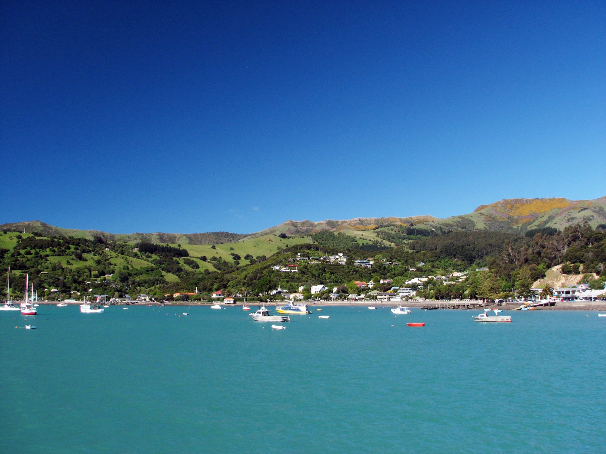
A small township of scattered houses along a green hillside above a turquoise harbour with moored yachts and fishing boats

Christchurch, Canterbury & the Chathams, New Zealand

Akaroa

Akaroa and its harbour seen from the end of the town wharf on Banks Peninsula. (J Montagu (HerrSchnapps) / Wikimedia Commons · CC BY 3.0)

A small harbour town on Banks Peninsula, about 84 kilometres from Christchurch, set on the flooded crater of an extinct volcano. Founded as a whaling port and settled by French colonists in 1840, it keeps French street names and colonial cottages, and lives on harbour cruises, cruise-ship visits and the rare Hector's dolphins that feed in its waters.

Neighbourhoods

  • The waterfront and the wharf
    • First-time visitors
    • Best for food
    • Boat trips

    Beach Road runs along the harbour edge past the main wharf, where cruises and fishing charters leave and cruise-ship passengers come ashore. Most of the town's cafés, galleries and shops are on this strip, with a stony beach, moored yachts and a view down the harbour to the hills.

    Open in Maps
  • The old town and the French streets
    • Historic district
    • Walks

    The blocks climbing the slope behind the waterfront keep the street names of the 1840 settlement — Rue Lavaud, Rue Balguerie — with weatherboard cottages, 19th-century churches, the museum and small gardens. The lanes are steep and quiet a few minutes above the harbour.

    Open in Maps
  • Children's Bay and the southern end
    • Quiet and residential
    • Viewpoints

    Past the lighthouse the road follows the shore south through a residential fringe of holiday houses to Children's Bay, where a farm walk and a sculpture-dotted paddock climb to views over the whole harbour.

    Open in Maps
  • Takamatua
    • Quiet and residential
    • Camping

    A small settlement in its own bay three kilometres north of Akaroa, on the main road into the town and formerly known as German Bay. It is a common base when the town itself is full, and an easy drive or long walk from the wharf.

    Open in Maps
  • Duvauchelle and the head of the harbour
    • Rural stays
    • Local life

    Where the harbour narrows, small farming settlements — Duvauchelle, Barrys Bay and Robinsons Bay — sit among paddocks that run down to the water. There is a hotel at Duvauchelle, built on an old pā site at Oinako, and the road over the hills towards Christchurch.

    Open in Maps
  • Ōnuku and the outer harbour road
    • Māori history
    • Quiet and residential

    South of the town a narrow road follows the harbour to Ōnuku, where a small marae and a 19th-century church stand above the water, and continues towards the rocky entrance and Akaroa Head.

    Open in Maps

Things to do

The harbour and wildlife

  • Akaroa Harbourattraction

    The drowned crater of one of two eroded centres of the extinct Banks Peninsula volcano, its Māori name Whakaroa meaning long harbour, worked by cruise boats, kayaks and fishing charters between steep basalt headlands and sea caves.

    Open in Maps
  • Akaroa Wharflandmark

    The town's long working wharf, where harbour cruises, dolphin trips and fishing boats tie up and cruise-ship tenders land their passengers.

    Open in Maps
  • Banks Peninsula Marine Mammal Sanctuaryattraction

    A large sanctuary, extended in 2020, protecting the waters off the peninsula for Hector's dolphin, the world's smallest dolphin species and the only cetacean found solely in New Zealand, often seen in the harbour.

    Open in Maps

History and museums

  • Akaroa Museummuseum

    The district museum at 71 Rue Lavaud, open since 1964, whose complex includes the 1840s Langlois-Eteveneaux cottage and the 1878 court house, and which tells the story of the French and British settlements.

    Open in Maps
  • Akaroa Lighthouselandmark

    The 8.5-metre wooden lighthouse completed at Akaroa Head in 1880, replaced by an automatic light in 1977 and re-erected at Cemetery Point in the town in 1980.

    Open in Maps
  • St Patrick's Churchlandmark

    A timber Catholic church of 1865 designed by Benjamin Mountfort and Maxwell Bury, the third on the site, built for a settlement whose French founders were nominally Catholic.

    Open in Maps
  • Ōnawe Peninsulalandmark

    A narrow tongue of land at the head of the harbour that held a large Ngāi Tahu pā, stormed by Te Rauparaha's war party in 1832, now reached on foot at low tide.

    Open in Maps

Walks and viewpoints

  • Children's Bay farm walktrail

    A short climb through farmland at the southern edge of the town, with outdoor sculpture and views over the harbour and the crater rim.

    Open in Maps
  • Banks Tracktrail

    A private walking route of several days, 31 kilometres in a circle from Akaroa over farmland and coastal cliffs by way of Flea Bay, Stony Bay and Hinewai Reserve.

    Open in Maps

Short trips from the town

  • Hinewai Reservepark

    A private reserve of about 1,400 hectares in the hills east of Akaroa, begun in 1987 on bought farmland and left to regenerate into native forest, with more than twenty public walking tracks.

    Open in Maps
  • Okains Baybeach

    A sandy bay on the outer coast of the peninsula, with a camping ground and a museum of Māori and colonial collections.

    Open in Maps
  • Le Bons Baybeach

    A long sandy beach in a farmed valley on the peninsula's eastern coast, reached by a winding road over the crater rim.

    Open in Maps

Eat and drink

Long-standing places and food districts in Akaroa. Hours, ratings and directions come from your maps app, always current.

Akaroa classics

  • Akaroa waterfront eatingneighborhood

    Beach Road and the wharf hold most of the town's kitchens, from fish-and-chip counters to bistros with French dishes on the board, trading heavily on the local salmon, blue cod and Akaroa's own harbour catch.

    Open in Maps
  • Rue Lavaud and the old French streetsneighborhood

    Bakeries, cafés and a village store line the old French streets behind the waterfront, the usual place for coffee, pies and picnic supplies before a boat trip or a walk.

    Open in Maps

Experience Akaroa

History

Akaroa Harbour was formed when the sea flooded the crater of a volcano that last erupted several million years ago. Ngāi Tahu held the peninsula, with settlements around the bays and a strong pā on the Ōnawe Peninsula at the head of the harbour; in the early 1830s a war party led by Te Rauparaha took Ōnawe with heavy loss of life, and the population of the area fell sharply. Whalers from Europe, America and Australia were working the harbour within a few years, trading with the remaining Ngāi Tahu communities.

In 1838 the French whaling captain Jean-François Langlois claimed to have bought the peninsula from local chiefs and returned to France to raise a colonising venture. His settlers sailed on the Comte de Paris and reached Akaroa in August 1840 — a few days after a British naval officer had raised the flag in the harbour, following the signing of the Treaty of Waitangi at Waitangi in February and at Ōnuku in May. The French families stayed, planting vines and gardens and laying out streets with French names under British sovereignty; the 57 settlers included a dozen Germans, and British and further German farmers followed.

For the rest of the 19th century Akaroa was a busy little port, shipping timber felled from the peninsula's forests, then cheese, wool and stock. Steamers crossed to Lyttelton, and the cleared hills turned to grass. Roads and refrigerated lorries ended the coastal shipping trade, and the town shrank into a quiet farming service centre before tourism revived it in the late 20th century. Cruise ships were diverted here after the earthquakes of 2010 and 2011 damaged the port of Lyttelton, rising to about ninety calls a season by 2019 and 2020, and numbers fell again once Lyttelton's new cruise berth opened.

Culture & Customs

Akaroa trades on being the most French place in New Zealand, and the surface of it is genuine enough: street signs read Rue, the museum keeps a settler cottage from the 1840s, and family names from the first ships still appear on farm gates and in the cemetery. The French language did not survive, and the village today is culturally Cantabrian, but the story of the 1840 landing remains the town's chief claim on visitors.

Ngāi Tahu history runs deeper. Ōnuku Marae, a few kilometres around the harbour, was one of the places where the Treaty of Waitangi was signed in 1840, and its church, opened in 1878, was the first non-denominational church in New Zealand. Place names across the peninsula — Ōnawe, Ōnuku, Takamatua, Wainui — are Māori, and the Ngāi Tahu settlement of 1998 restored the iwi to a central role in the region's affairs.

Village life has the rhythm of a small place with a large audience. Artists, potters and gallery owners have settled here in numbers, the boats and buses run to a tourist timetable, and residents divide the year between the loud months and the empty ones. Conservation is a shared preoccupation: many landowners fence off gullies to let native bush return, and the survival of Hector's dolphins in the harbour is followed closely.

Daily Life

Akaroa has roughly 640 permanent residents, and the wider Banks Peninsula ward about 8,800. The town's population multiplies in the summer holidays and again on every cruise-ship day, when passengers can outnumber residents several times over. Many houses are holiday homes, and a large share of the workforce commutes from settlements around the harbour or from Christchurch.

Tourism is the main employer: cruises, kayak and bike hire, cafés, accommodation, galleries and the shore-excursion trade. Farming continues on the hills behind — sheep, beef and dairy — and there is a small fishing fleet, along with salmon farmed in sea cages in the harbour. The school, the health centre, the museum and the council service centre make up most of the rest.

Everyday needs mean a drive to Christchurch, and the winding road over the crater rim shapes life on the peninsula: an hour and a half to a hospital, a supermarket run planned in advance, and slow going in fog or ice. Housing costs, water supply in dry summers and the pressure of cruise-ship numbers on a village of this size are the recurring local debates. Out of season the waterfront is almost empty, and the loudest sound is the wind over the harbour.

Food

Akaroa's best-known product is salmon, farmed in sea cages in the harbour, as it has been since the early years of New Zealand salmon farming, and often served raw or lightly cured. The harbour and the coast also supply blue cod, groper, crayfish, mussels and, in the right months, pāua; fish and chips eaten on the wharf is the classic Akaroa meal, and smoked fish and pickled cockles turn up in the shops.

Dairy country behind the town gives it cheese, made on the harbour edge from peninsula milk, and milk, cream and butter appear in the village bakeries. Kitchens in the town lean on their French story with dishes such as bouillabaisse, crêpes and duck, and peninsula vegetables, berries, honey and preserves are sold in the village.

The wider Canterbury larder fills out the rest: lamb from the hill farms, cherries and apricots trucked from inland Canterbury in summer, and salmon from the Mackenzie canals. Wine comes mostly from Waipara to the north, though a few small vineyards were planted on the peninsula's warm slopes, continuing something the French settlers attempted in the 1840s. Craft beer, cider from Canterbury orchards and coffee roasted in Christchurch complete a very local drinks list.

Planning tools

Budget

Akaroa is a resort village with limited beds, so accommodation is dearer than Christchurch and close to fully booked in January and at Easter. Harbour cruises and dolphin-swimming trips are the main activity cost. Staying at a holiday park or in one of the settlements around the harbour, and eating from the bakery and the village shops, keeps a visit cheap.

Daily Budget Midrange
USD 150–290 (motel, cottage or lodge, restaurant meals, a hire car, a harbour cruise)
Daily Budget Shoestring
USD 55–90 (hostel or holiday park, supermarket and bakery food, the Christchurch bus)

Prices and crowds follow the cruise-ship calendar, so an overnight stay is quieter than a day visit; book summer beds weeks ahead.

Best Time to Visit

November to April, when the harbour is calmest for boat trips and swimming and the peninsula tracks are dry. February and March are the warmest and settled months. Winter is cool, green and very quiet, with fewer cruises running and some businesses closing for a break, but the colonial streets and the drive over the hills are good in any season.

Suggested Number of Days

The village itself is small, and many people come for a day from Christchurch. A night or two allows for a harbour trip and the walks above the town. Three days suits the outer bays of Banks Peninsula, which are slow to drive.

First Visit
1–2 days
With Surroundings
3 days

Transportation

The township is walkable end to end, and cars are more nuisance than help along the narrow waterfront in summer. A shuttle service runs between Christchurch and Akaroa, and there are day tours, but reaching the outer bays, Ōnuku or Hinewai needs a vehicle. Water taxis and cruises cover the harbour, and kayaks and bikes can be hired in the town.

The roads over the crater rim are steep, narrow and winding with blind corners; allow far longer than the distance suggests and watch for stock and cyclists.

Airport & Station Connections

Akaroa is 84 kilometres from Christchurch by road and is the terminus of State Highway 75, a drive of about an hour and a half through Little River and over the crater rim. A shuttle service and day tours run from the city. Cruise ships anchor off the town in the summer season and bring passengers ashore by tender; there is no rail link and no airport on the peninsula.

Walkability

The flat waterfront strip takes about twenty minutes to walk from the lighthouse to the wharf and the museum, which is all most visits need. Behind it the streets climb steeply, so the old town involves short, sharp hills, and Children's Bay and Takamatua are longer walks along the shore road. Footpaths are narrow in places and the harbour road carries tour buses.

Safety

The town is safe, with very little crime. Most risks are on the water and on the roads: the harbour can turn choppy in a nor'easter, water temperatures are cold year-round, and the crater-rim roads are the main hazard for visitors, with steep drops and no barriers in places. Banks Peninsula's clifftop farm tracks are slippery after rain.

Drive the peninsula roads slowly and in daylight, wear a lifejacket in small craft, keep the legal distance from dolphins and seals, and shut every farm gate on the walking tracks. Check current official travel advice before travelling.

Climate

A mild coastal climate, a degree or two warmer and more sheltered than Christchurch in the harbour basin, with more wind and cloud on the crater rim. Summer is December to February in the southern hemisphere; sea breezes and southerly changes can cool an afternoon quickly.

Summer
warm and mostly dry, usually 19–24°C by day, hotter when a nor'wester blows over the hills
Winter
cool and green, with days around 11–13°C, frosts in the sheltered valleys and snow only on the highest rim

Local Customs

The French heritage is a matter of street names, history and a little branding rather than a living French community, and residents are used to gentle jokes about it. This is otherwise a Canterbury village: casual dress, first names, and a small permanent population that lives alongside thousands of day visitors. Ōnuku Marae, where Ngāi Tahu chiefs signed the Treaty of Waitangi in 1840, is a working community place visited by arrangement.

Tipping is not expected. Ask before photographing people or private cottages, keep noise down in the residential streets at night, and respect the marked distances from dolphins on the water.

Common Payment Methods

The currency is the New Zealand dollar. Cards and contactless payment are taken in shops, cafés and tour offices, and there is an ATM in the village, though it is worth drawing cash in Christchurch for markets, honesty boxes at farm gates and the smaller settlements around the harbour.