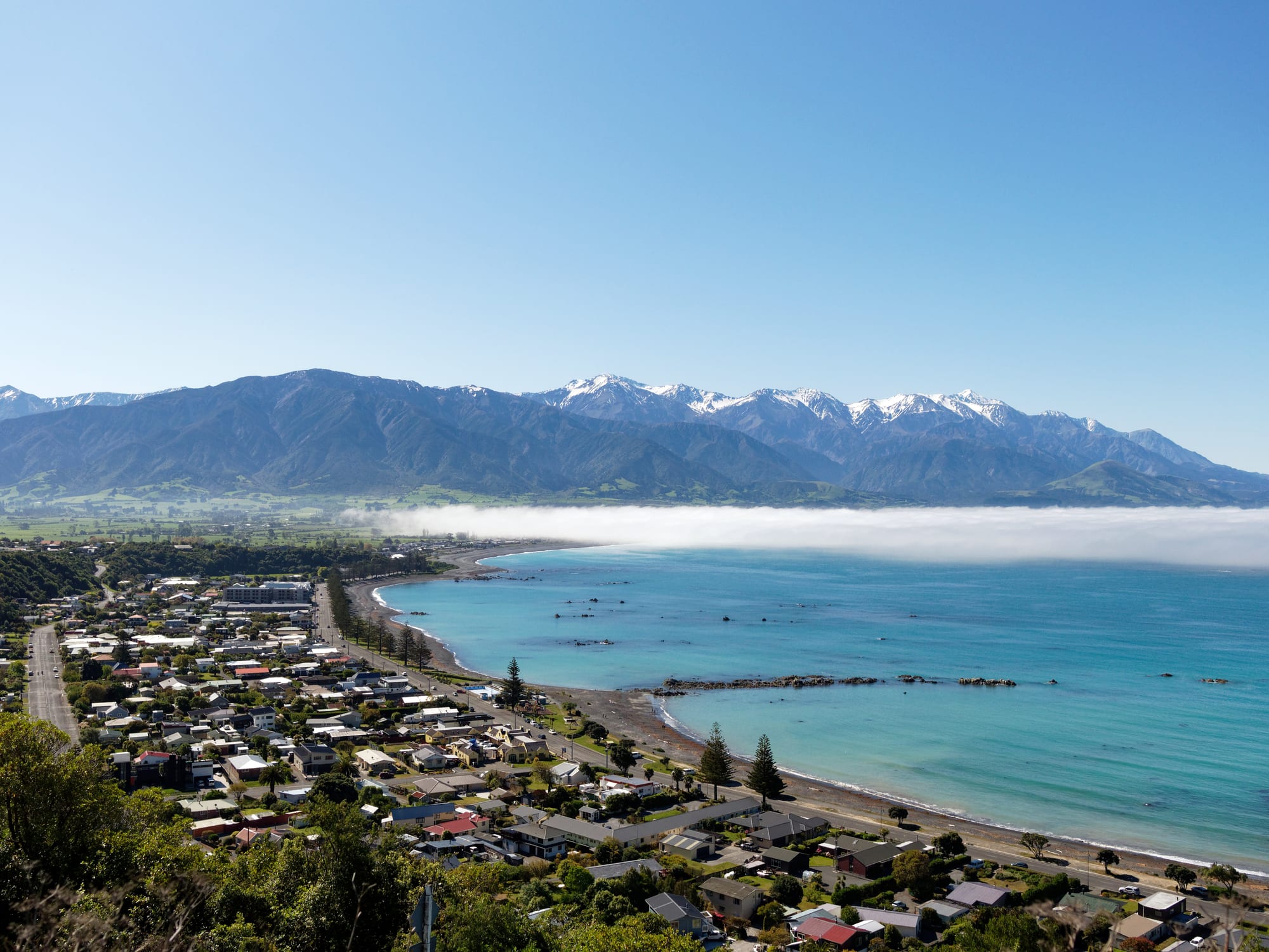
A small coastal town beside a turquoise bay, with a bank of low cloud and a snow-capped mountain range rising behind it

Christchurch, Canterbury & the Chathams, New Zealand

Kaikōura

Kaikōura and its bay seen from the hills of the Kaikōura Peninsula, with the Seaward Kaikōura Range behind. (Clilly4 / Wikimedia Commons · CC BY-SA 4.0)

A small town on the east coast of New Zealand's South Island, built on a rocky peninsula where the Seaward Kaikōura Range drops almost straight into the Pacific. A deep submarine canyon close to shore brings whales, dolphins, seals and seabirds within sight of land, and the marine wildlife trips that began in the 1980s now carry the town's economy alongside fishing and farming.

Neighbourhoods

  • The town centre and the Esplanade
    • First-time visitors
    • Best for food
    • Close to public transport

    The main street, West End, runs a couple of blocks back from the shingle beach, with cafés, seafood shops, tour offices and most of the town's motels. The Esplanade follows the shoreline to the base of the peninsula, and the railway station sits just behind the shops.

    Open in Maps
  • Kaikōura Peninsula
    • Walks and wildlife
    • Viewpoints
    • Quiet and residential

    The limestone headland that shelters the town, with houses on its lower slopes and farmland and clifftop paths above. A road runs out to Point Kean, where fur seals haul out on the rocks, and tracks climb to viewpoints over the bay and the ranges.

    Open in Maps
  • South Bay
    • Boats and diving
    • Quiet and residential

    The bay on the southern side of the peninsula, where the working harbour and the marina are. Fishing boats and wildlife trips leave from here, and a small residential area sits above the water, about three kilometres from the town centre.

    Open in Maps
  • Hapuku and the Mount Fyffe foothills
    • Rural stays
    • Mountain views

    Farmland and vineyards north of the town, where the plain narrows between the beach and the mountains. Lodges, cottages and campsites are scattered along the side roads that run inland towards the Mount Fyffe track.

    Open in Maps
  • The southern coast road
    • Beaches
    • Camping

    South of the peninsula the highway and railway squeeze between the surf and the cliffs past Goose Bay and Oaro, a string of stony bays, campgrounds and holiday houses with seals on the rocks and little else.

    Open in Maps

Things to do

Wildlife and the sea

  • Kaikōura Canyonattraction

    A submarine canyon that begins only a few kilometres offshore and drops more than a kilometre, bringing deep-water nutrients, squid and sperm whales unusually close to the coast.

    Open in Maps
  • Point Kean seal colonyattraction

    The tip of the peninsula, where New Zealand fur seals rest on the rock platform and among the car park boulders and are watched from a marked distance.

    Open in Maps
  • Ōhau Pointviewpoint

    A coastal lookout over a large fur seal colony about 25 kilometres north of the town, beside the highway between Kaikōura and the Clarence River.

    Open in Maps

Walks and viewpoints

  • Kaikōura Peninsula Walkwaytrail

    A clifftop and shoreline loop around the peninsula, passing seal haul-outs, seabird colonies and views back to the snow line of the ranges.

    Open in Maps
  • Mount Fyffetrail

    The nearest peak of the Seaward Kaikōura Range, reached by a long four-wheel-drive track from the foothills, with a hut near the summit and views along the whole coast.

    Open in Maps

History and museums

  • Fyffe Housemuseum

    The oldest surviving building in Kaikōura, a small colonial cottage left from the whaling station Robert Fyffe established at Te Wai-o-puka in 1842, parts of it set on whale-bone piles.

    Open in Maps
  • Kaikōura Museummuseum

    The district museum, with collections on Māori settlement, whaling, farming and the 2016 earthquake that reshaped the coast.

    Open in Maps

Short trips from the town

  • Clarence Riverattraction

    The longest river in Canterbury, braided near its mouth north of Kaikōura and known for rafting and packrafting trips through its inland gorges.

    Open in Maps
  • Hanmer Springsattraction

    A spa village inland to the south-west with thermal pools and forest walks, reached over the Inland Kaikōura Road.

    Open in Maps

Eat and drink

Long-standing places and food districts in Kaikōura. Hours, ratings and directions come from your maps app, always current.

Kaikōura classics

  • Roadside crayfish caravansmarket

    Caravans and shacks parked beside the highway north of the town sell crayfish cooked and split to order, along with paua fritters and whitebait when they are in season — the food the town is named for.

    Open in Maps

Where to eat in town

  • West Endneighborhood

    The main street holds most of the town's cafés, bakeries, pubs and restaurants, several of them built around blue cod, mussels and crayfish, with fish shops selling the same catch to take away.

    Open in Maps
  • South Bay harbourneighborhood

    A small cluster of seafood outlets and cafés beside the working harbour, where the fishing boats and wildlife trips come in.

    Open in Maps

Experience Kaikōura

History

The peninsula was settled early and repeatedly. Middens and cooking sites on its shores record moa hunting and centuries of fishing, and the name Kaikōura — kai, food, and kōura, crayfish — is linked to the traveller Tama-ki-te-rangi, who is said to have eaten crayfish here. Successive iwi occupied the headland, and by the early 19th century Ngāti Kurī, a hapū of Ngāi Tahu, held the district from pā sites whose defences can still be traced above the sea.

European whalers arrived in the 1840s. Robert Fyffe set up a shore station in 1842 at Te Wai-o-puka, a headland of the peninsula, and the cottage now known as Fyffe House survives from that time, its foundations partly whale vertebrae. Whaling gave way to sheep farming on the flats and high country, and to fishing for crayfish and cod. The Main North Line railway reached the town from both directions in the 1940s, linking it to Christchurch and Picton, and the coast road brought passing traffic.

Modern Kaikōura was made by wildlife. Sperm whales feed year-round in the canyon offshore, and in 1987 a group of local Māori families founded a whale-watching venture that grew into the town's largest employer and changed it from a stop on the highway into a destination. On 14 November 2016 a magnitude 7.8 earthquake struck the district, lifting sections of the seabed clear of the water, burying the highway and railway under landslides and cutting the town off by land for weeks. Both routes were rebuilt, and the raised rock platforms are now part of the shoreline.

Culture & Customs

The town's identity rests on the sea. Crayfishing families, charter skippers, boat crews and marine scientists all work out of the same two small harbours, and conversation turns on swell, wind and quota. Ngāti Kurī is central to that culture: the hapū's involvement in tourism means many visitors first hear about the coast in Māori terms, with karakia before a boat leaves and stories of Tama and of the taniwha of the canyon told alongside the biology of the whales. Takahanga Marae stands on a terrace above the town centre.

Conservation is unusually prominent for a place of this size. The Hikurangi Marine Reserve and the wider Kaikōura (Te Tai o Marokura) marine management area were created in 2014 after years of negotiation between fishers, iwi, tour operators and scientists led by the local guardians group Te Korowai o Te Tai o Marokura, and the town has long promoted itself on environmental certification. Rules about how close boats and swimmers may come to whales, dolphins and seals are taken seriously, and residents are quick to correct visitors who climb among the seals for photographs.

Otherwise this is a South Island country town: a rugby club and an A&P show, a small museum run largely by volunteers, fundraising raffles in the pub, and a long collective memory of the 2016 earthquake and the months of isolation that followed. Seasonal workers and backpackers pass through in numbers each summer, giving the main street a more international feel than the district's size suggests.

Daily Life

About 2,350 people live in the town and roughly 4,300 in the wider Kaikōura District, which stretches along the coast and into the ranges. The resident population is older than the national average, and the summer population is several times larger, which shapes everything from supermarket queues to the availability of rooms for workers.

Tourism, fishing and farming carry the economy in that order. Whale watching, dolphin swimming, scenic flights, diving and albatross trips employ crew, guides, drivers and office staff; the crayfish fishery supplies both local stalls and export markets; and sheep, beef and some dairy occupy the narrow plain and the hill country behind it. A small commercial centre, the school, the health centre and the district council make up most of the remaining work. The earthquake rebuild brought years of construction traffic and, with it, a longer stretch of new road and cycleway along the coast.

The day starts early, with boats leaving soon after dawn and tour groups assembling on West End before the shops open. Housing supply is the standing local issue, as holiday homes and short-term rentals compete with workers for a small stock, and the district also debates water quality, coastal erosion and how many visitors the peninsula's tracks can take. Serious hospital care means a drive to Blenheim or Christchurch.

Food

Crayfish — kōura, the spiny rock lobster of New Zealand waters — is the dish the town is named for and still the one people come to eat. It is usually served plainly: split, grilled or boiled, with butter or garlic, from a restaurant table or from a caravan beside the highway north of town. Prices follow the export market, and the cheapest way to try it is a half tail from a roadside stall rather than a whole one in a dining room.

The rest of the local catch is just as good and much cheaper. Blue cod and groper come battered in fish and chip shops, green-lipped mussels are steamed in wine, pāua, the black-shelled abalone, appears as fritters minced with egg and onion, and whitebait is bound into thin patties in spring. Scallops, octopus and salmon from Canterbury's hydro canals fill out menus, and smoked fish is sold from shop counters on the main street.

Away from the sea the food is Canterbury food: lamb and beef from the hill country, farm-gate honey, and stone fruit and berries trucked in from inland valleys in summer. Bakeries sell mince and cheese pies to travellers and shearing gangs alike. The district has a handful of small vineyards on the foothills north of the town, and their cellar doors double as lunch stops.

Planning tools

Budget

Beds in Kaikōura are cheaper than in Queenstown but limited, and prices climb through the summer holidays, when the town fills. The wildlife trips are the real expense: a whale-watching boat or flight, a dolphin-swimming trip or a diving charter can cost more than a night's accommodation. Walking the peninsula, the seal colonies and the beaches cost nothing.

Daily Budget Midrange
USD 150–280 (motel or lodge, restaurant meals, a hire car, one wildlife trip)
Daily Budget Shoestring
USD 55–90 (hostel bed or holiday park, supermarket food and fish and chips, shared car or the bus)

Book a wildlife trip for early in a stay so there is time for a second attempt if the sea is too rough, and book any bed well ahead for January.

Best Time to Visit

Trips run all year. November to April brings the calmest seas, the warmest water for swimming with dolphins and long evenings on the peninsula, but also the crowds of the New Zealand summer holidays. Winter is quiet and often clear, with fresh snow low on the ranges behind the town, and dusky dolphins and seals are present year-round.

Suggested Number of Days

Most visits last one or two nights, and a second night is worth having because boats and flights are cancelled in rough weather. Longer stays are for the mountain tracks, the coast road and trips inland.

First Visit
1–2 days
With Surroundings
3 days

Transportation

The town is small enough to cross on foot, and the peninsula road is an easy walk or cycle from the centre. Most visitors arrive by car, which is also what the coast road and the inland valleys need. Intercity buses stop in the town on the Christchurch–Picton route, and the Coastal Pacific train calls at the station in season. Tour operators collect passengers from accommodation in the town.

Fuel and shops are sparse between Kaikōura and Blenheim, so fill up before long coastal drives.

Airport & Station Connections

Kaikōura sits on State Highway 1 about 180 kilometres north of Christchurch, a drive of two and a half to three hours, and roughly 130 kilometres south of Picton and its Cook Strait ferries. Buses and the Coastal Pacific train follow the same coastal route. The nearest airports with scheduled flights are Christchurch and Blenheim; the local aerodrome is used for scenic and whale-spotting flights.

Walkability

The centre is flat and compact, with the beach, the shops, the station and many motels within a few hundred metres of one another. The seal colony at Point Kean is about three kilometres out along the shore road, and South Bay a similar distance over the neck of the peninsula; both are pleasant walks in fine weather. Footpaths thin out beyond the town, and the highway is busy with trucks.

Safety

The town is safe and crime is low. The hazards are natural: the coast is exposed, with cold water, strong currents and sudden swells over the rock platforms, and the peninsula cliffs are unstable in places. The region sits on active faults, and the 2016 earthquake caused landslides along the coast. Fur seals look docile but bite, and a seal between a walker and the sea will defend its route.

Keep at least ten metres from seals and never block their path to the water, watch the swell when crossing rock platforms below the cliffs, and check the alpine forecast before walking to Mount Fyffe. Check current official travel advice before travelling.

Climate

A mild, breezy maritime climate, drier than the mountains just inland. The sea keeps temperatures even, and southerly changes can drop them quickly at any time of year. Conditions at sea matter more than the forecast on land, since wind rather than rain cancels boat trips.

Summer
mild and settled, with December-to-February days usually around 18–22°C and warm, dry spells in a nor'wester
Winter
cool rather than cold, with days around 11–13°C, frosts inland and snow on the ranges behind the town

Local Customs

Kaikōura is a working fishing and farming town as well as a resort, and the pace is informal: first names, casual dress and boots or jandals almost everywhere. The land and the whale-watching business belong in part to Ngāti Kurī, the local hapū of Ngāi Tahu, and Māori names, karakia and protocols are part of many tours. Takahanga Marae above the town is a community place, not a visitor attraction, and is entered only by invitation.

Tipping is not expected. Remove shoes when entering a home, ask before photographing people, keep well clear of wildlife on the rocks, and follow crew instructions about noise and movement on the boats.

Common Payment Methods

The currency is the New Zealand dollar. Cards and contactless payment work in shops, cafés and tour offices, and there are ATMs on the main street, but some roadside seafood caravans and small campsites take cash only, so a little is worth carrying. Mobile coverage fades on the inland roads.