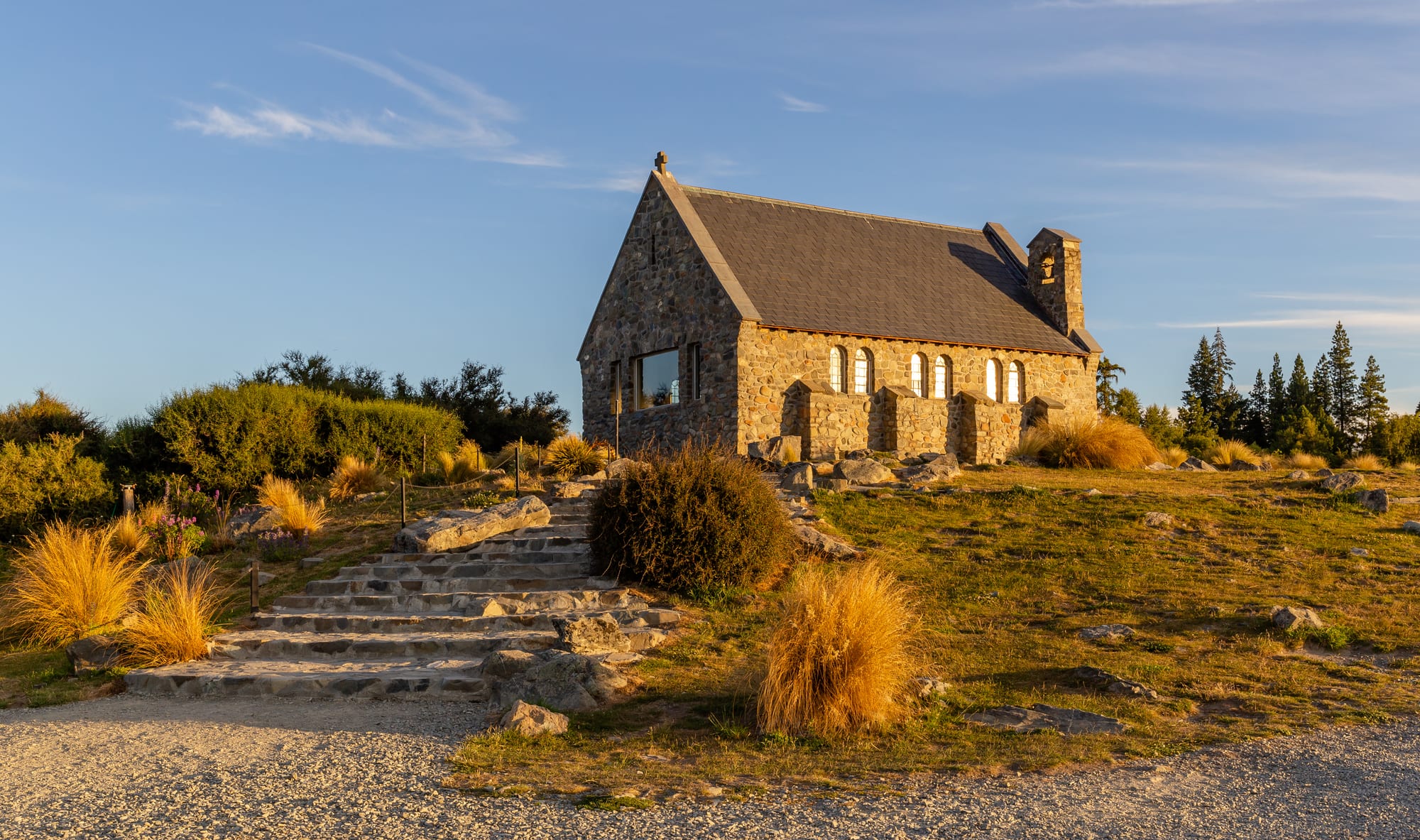
A small stone church with a steep grey roof on a low hill of tussock and rock in warm evening light

Christchurch, Canterbury & the Chathams, New Zealand

Lake Tekapo

The Church of the Good Shepherd on the lakeshore at Lake Tekapo. (Michal Klajban / Wikimedia Commons · CC BY-SA 4.0)

A small village on the southern shore of Lake Tekapo, in the high, dry Mackenzie Basin of inland Canterbury. It grew from a high-country sheep station and a road stop into a tourist settlement built around the turquoise, glacier-fed lake, the little stone Church of the Good Shepherd and the observatory on Mount John, at the heart of one of the world's largest dark sky reserves.

Neighbourhoods

  • The village centre
    • First-time visitors
    • Best for food
    • Close to public transport

    A short row of shops, cafés, tour desks and accommodation on the highway above the lake outlet, with the supermarket, hot pools road and information centre all within a couple of hundred metres. Almost every visitor stays or stops here, and the lake is a two-minute walk downhill.

    Open in Maps
  • The lakefront and the church point
    • Walks and viewpoints
    • Photography

    The grassy shoreline east of the bridge, where the stone church and the bronze sheepdog statue stand on a low rise above the water. Paths follow the shore between rocks, tussock and lupins, and the view runs north up the lake to snow peaks.

    Open in Maps
  • The slopes above the highway
    • Quiet and residential
    • Lake views

    Streets of holiday houses and lodges climbing the hillside behind the village, many built for the view over the lake and the Southern Alps. Quiet, exposed to the wind, and a steep but short walk from the shops.

    Open in Maps
  • Mount John and the western shore
    • Stargazing
    • Walks and viewpoints

    The rounded hill immediately north-west of the village, reached by a walking track or a summit road, with the university observatory on top and tussock slopes falling to the lake. Beyond it the shore road runs towards Lake Alexandrina and the high-country stations.

    Open in Maps
  • The canal and the eastern flats
    • Cycling
    • Nature and wildlife

    Dry, treeless country south-east of the village where the hydro canal carries lake water towards the power stations. The canal road is used by cyclists and passes salmon farming pens fed by cold glacial water.

    Open in Maps

Things to do

The lake and its landmarks

  • Lake Tekapoattraction

    A long glacial lake whose milky turquoise colour comes from rock flour ground by the glaciers of the Southern Alps and carried down the Godley River.

    Open in Maps
  • Church of the Good Shepherdlandmark

    A small church of concrete clad in local stone, built on the lakeshore in 1935 as a memorial to the district's early settlers, with a window behind the altar framing the lake and mountains.

    Open in Maps
  • Mackenzie Basinattraction

    The broad, dry intermontane basin around the village, a landscape of tussock, braided rivers and glacial lakes ringed by mountains.

    Open in Maps

Stargazing and viewpoints

  • Mount John University Observatoryattraction

    The University of Canterbury's observatory on the hill above the village, used for research and for guided night-sky tours, with daytime views over the whole basin.

    Open in Maps
  • Aoraki Mackenzie International Dark Sky Reserveattraction

    A large reserve declared in 2012 over the Mackenzie Basin and the national park, where lighting controls protect some of the clearest night skies in the southern hemisphere.

    Open in Maps

Short trips from the village

  • Lake Alexandrinaattraction

    A quiet lake and wildlife refuge a short drive north-west of the village, well known for its brown and rainbow trout and for grebes and waterfowl.

    Open in Maps
  • Lake Pukakiattraction

    A larger turquoise lake about half an hour south-west, with the classic view straight up its length to Aoraki / Mount Cook.

    Open in Maps
  • Aoraki / Mount Cook National Parkpark

    The country's highest mountains, glaciers and alpine tracks, reached by the road up the western side of Lake Pukaki.

    Open in Maps
  • Fairlieneighborhood

    A farming town east over Burkes Pass on the road to Christchurch, known for the pies of its bakehouse and as the gateway to the Mount Dobson ski field.

    Open in Maps
  • Twizelneighborhood

    A town built in the 1960s for hydro construction workers, about forty minutes south, now a base for the lakes, canals and the national park.

    Open in Maps

Eat and drink

Long-standing places and food districts in Lake Tekapo. Hours, ratings and directions come from your maps app, always current.

Tekapo classics

  • The village shops and cafésneighborhood

    A compact strip of cafés, bakeries, takeaways and restaurants above the lake, several with terraces facing the water and a strong showing of Japanese, Korean and Chinese cooking alongside New Zealand staples.

    Open in Maps
  • Mackenzie Basin salmonrestaurant

    King salmon farmed in the cold hydro canals near the village is sold fresh and smoked and appears on local menus as sashimi, in rice bowls and grilled.

    Open in Maps

Nearby food

  • Fairlie bakery piesneighborhood

    The small town east over the pass is known throughout the country for the pies of the Fairlie Bakehouse, and the queue of travellers outside is part of the drive to or from Christchurch.

    Open in Maps
  • High-country lamb and produceneighborhood

    Restaurants in the basin's towns lean on Canterbury lamb, merino, salmon and cherries and apricots grown in the dry inland valleys.

    Open in Maps

Experience Lake Tekapo

History

For centuries the Mackenzie Basin was crossed rather than settled. Ngāi Tahu parties travelled its passes and river valleys on seasonal journeys, hunting weka and eels and carrying pounamu and other goods between the coast and the interior, and the lake's name comes from a Māori original usually given as Takapō. Permanent occupation was hard in a basin of frost, wind and thin soils.

European pastoralists arrived in the 1850s, and the basin gained its English name from James Mackenzie, a Scottish drover accused in 1855 of stealing sheep and driving them into the empty tussock country. Great sheep runs were laid out, including the Tekapo station near the lake outlet, but before the hydro schemes the place amounted to little more than two station homesteads, a private hotel and a few holiday cottages. The township began to grow only after the power stations were built in the 1940s.

The Church of the Good Shepherd was built on the lakeshore in 1935 as a memorial to the district's pioneer families, using stone and timber gathered locally, and became one of the most photographed buildings in the country; a bronze statue honouring the collie sheepdogs of the high country, commissioned by Mackenzie Country residents and cast in London, stands nearby. From the 1930s the Waitaki hydro scheme reshaped the basin, raising Lake Tekapo behind a control gate, digging canals between the lakes and building power stations. The University of Canterbury opened its observatory on Mount John in the 1960s, taking advantage of the clear dry air; tourism followed the road, and the declaration of the Aoraki Mackenzie International Dark Sky Reserve in 2012 turned darkness itself into the village's principal attraction.

Culture & Customs

Two cultures share the village: high-country farming and astronomy. The pastoral tradition is visible in the merino flocks on the surrounding stations, the dog trials, shearing and A&P shows of the wider Mackenzie, and the memorials to pioneers and working dogs beside the lake. Families who have run the same runs for generations regard the basin as a workplace rather than scenery, and the tension between farming, conservation and tourism is a live local conversation.

The night sky gives the place its second identity. Lighting rules keep streets and buildings dim, tour groups climb to the observatory after dark, and both Māori and European star knowledge are part of what visitors are told: Matariki, the cluster whose rising marks the Māori new year, and Puanga are explained alongside the Magellanic Clouds and the Southern Cross. The reserve has made astronomy a livelihood as well as a science here.

The population is small and seasonal, with a large share of workers from overseas on working holidays, and the village empties and fills with the tourist calendar. Manners are informal and practical, with the shared habits of a cold, windy place: layers, early starts, weather talk and a willingness to help strangers. Visitors are asked to respect two things above all — the church as a working place of worship, and the darkness.

Daily Life

Fewer than a thousand people live in the village permanently, and the resident count rises many times over with visitors in summer. Almost all local work is tourism: accommodation, cafés, tour guiding, the hot pools complex, the observatory tours and the petrol station and supermarket that serve travellers crossing the island. Farming on the surrounding stations and hydro-electric operation and maintenance provide the rest, with salmon farming in the canals a newer employer.

Services are those of a small settlement: a primary school, a medical centre with limited hours, a volunteer fire brigade and a police presence measured in individuals. Secondary schooling, hospital care and any large shopping mean a drive to Fairlie, Timaru or Christchurch, and many families travel routinely for things city residents take for granted.

The day is shaped by the road and the sky. Coaches and campervans arrive through the morning and afternoon, the shops are busiest in the middle of the day, and the evening turns over to stargazing tours that run until well after midnight. Housing is the sharpest local problem: holiday homes and short-term letting take up much of the village, leaving seasonal workers with little, and residents also worry about pressure on the lakeshore, the spread of introduced lupins that visitors come to photograph, water use and irrigation in the basin, and whether growth can be kept within what a tiny settlement can carry.

Food

Food in the basin follows the land and the cold water. King salmon raised in the hydro canals near the village is the local speciality, sold fresh and smoked from roadside outlets and served raw as sashimi, in rice bowls or grilled with lemon. Canterbury lamb and high-country merino appear on almost every menu, and wild venison, rabbit and hare are part of the district's hunting tradition.

The dry inland climate suits fruit: cherries, apricots and peaches from the dry inland valleys fill roadside stalls in summer, and the Waitaki Valley to the south-east has a small, cool-climate wine industry making pinot noir and riesling. Trout from the lakes and rivers is a sport catch rather than a restaurant dish, so anglers cook their own.

Everyday eating is travellers' food done in a New Zealand accent: the bakery mince or steak pie, famously good in Fairlie over the pass, the flat white with a slice, fish and chips, and burgers built around local beef and lamb. The village's seasonal workforce has left a lasting mark, so a small settlement in the tussock also offers ramen, Korean fried chicken, Chinese noodles and Japanese rice dishes, eaten looking out at a glacial lake.

Planning tools

Budget

Tekapo is a small village with limited beds and high seasonal demand, so accommodation is expensive for what it is, especially from December to February and during the lupin flowering. Food is dearer than in Christchurch, and the main extras are a stargazing tour, the hot pools and petrol, which is costly this far inland.

Daily Budget Midrange
USD 160–300 (motel or lodge with a lake view, restaurant meals, a hire car, a guided stargazing tour)
Daily Budget Shoestring
USD 60–100 (hostel or holiday park, supermarket food, lakeshore walks and the Mount John track)

Beds are cheaper in Twizel or Fairlie if Tekapo is full; the lakeshore, the church point and the walk up Mount John cost nothing, and the night sky is free to anyone who walks away from the streetlights.

Best Time to Visit

November and December bring long days, warm weather and the flowering lupins along the shore; January and February are warmest and busiest. March and April are settled and quieter. Winter is cold and often brilliantly clear, which makes it the best season for stargazing and for the nearby ski fields, though nights are well below freezing.

Suggested Number of Days

One night is enough for the village and a clear-sky evening, and two allow for cloud. Three or four days suit travellers using it as a base for the wider basin and the mountains, or those walking and cycling rather than driving.

First Visit
1–2 days
With Surroundings
3–4 days

Transportation

The village is small enough to cross on foot in fifteen minutes. Everything beyond it — the lakes, the canals, the national park — needs a car, since local public transport does not exist and taxis are few. Long-distance coaches between Christchurch and Queenstown stop in the village, and hired bicycles serve the flat roads along the hydro canals.

Fill up with fuel before long inland stretches, and expect ice on the roads and the Mount John access on winter mornings.

Airport & Station Connections

Tekapo sits on State Highway 8, roughly three hours by road from Christchurch and about three and a half from Queenstown, and most visitors arrive by hire car, campervan or coach on that route. The nearest airports are at Christchurch and Queenstown; Timaru, about two hours east, is the closest town of any size on the coast.

Walkability

The village itself is walkable and flat along the shore, with the shops, the church and the lakefront paths all close together. Distances grow quickly beyond it: the observatory is a steep climb of several hundred metres, and the lakes and mountains are driving distances apart, so a car makes the difference.

Safety

The village is very safe, with occasional theft from parked cars at trailheads the main concern. The environment deserves respect: the lake is glacier-fed and cold enough to cause trouble quickly, mountain weather changes fast, winter roads ice over, and the high, thin, clear air burns skin fast in summer. Night-time walking for stargazing means unlit ground and cold.

Take warm layers and a torch for stargazing even in summer, check road conditions and carry chains in winter, and treat the lake as cold water rather than a swimming pool. Check current official travel advice before travelling.

Climate

A dry inland climate at about 700 metres above sea level, with big differences between day and night and between seasons. Rainfall is low, sunshine high and the air very clear, which is why the skies are protected. Strong nor'west winds funnel down the basin. In the southern hemisphere summer falls in December–February.

Summer
warm, dry and bright, with days often in the low twenties °C and cool nights
Winter
cold and clear, with daytime temperatures in single figures °C, hard frosts, sub-zero nights and snow on the surrounding ranges

Local Customs

Tipping is not expected and service is informal. The village is a working settlement as well as a resort: high-country farming families live here and residents are protective of the lakeshore, the night sky and the church, which is an active place of worship where quiet and respect are asked for and photography inside is not permitted. The basin lies in the rohe of Ngāi Tahu, and many place names are Māori.

Keep lights low and off other people's cameras after dark, do not use drones or tripods inside the church grounds where signs prohibit them, and camp only where freedom camping is signposted as allowed.

Common Payment Methods

The currency is the New Zealand dollar. Cards and contactless payment are accepted in the shops, cafés, hot pools and tour offices, sometimes with a small credit-card surcharge. There is limited banking in the village, so carry some cash for small operators and for the smaller settlements further into the basin.