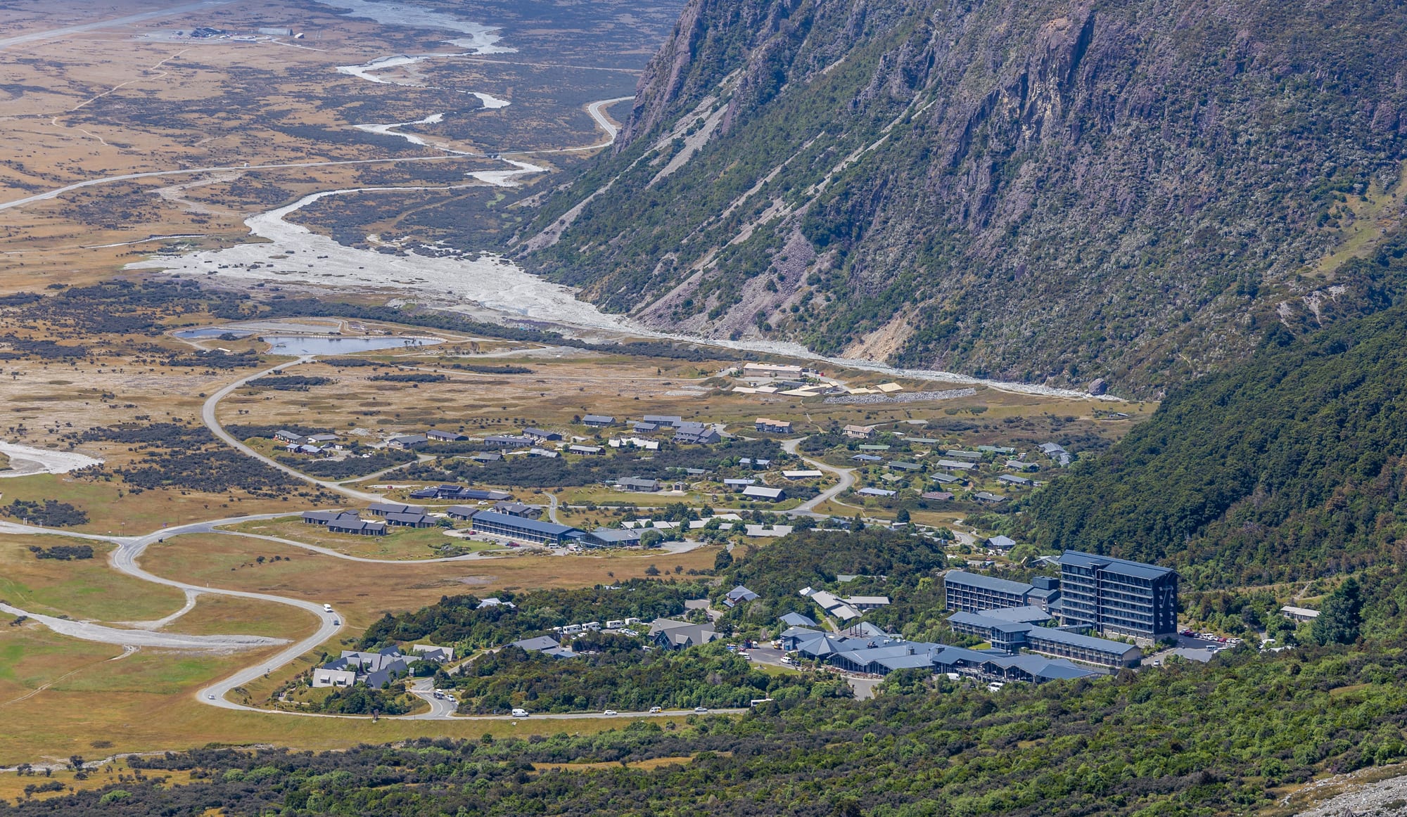
A small settlement of low buildings and winding roads on a valley floor beside a braided riverbed below steep mountainsides

Christchurch, Canterbury & the Chathams, New Zealand

Mount Cook Village

Mount Cook Village on the floor of the Hooker Valley, seen from the slopes above. (Michal Klajban / Wikimedia Commons · CC BY-SA 4.0)

A tiny alpine settlement inside Aoraki / Mount Cook National Park, in the Hooker Valley of inland Canterbury. Built around the Hermitage hotel and a park visitor centre, it houses guides, rangers and hospitality staff rather than a conventional community, and exists to give access to New Zealand's highest mountains, its longest glaciers and the walks that start at its edge.

Neighbourhoods

  • The Hermitage and the village centre
    • First-time visitors
    • Mountain views
    • Best for food

    The cluster of hotel buildings, a café, a bar, an alpine centre and the national park visitor centre on the low terrace above the valley floor. Almost all beds, meals and information are here, within a few minutes' walk of one another, with Aoraki visible up the valley on clear days.

    Open in Maps
  • The residential streets
    • Quiet and residential
    • Walks and viewpoints

    A loop of small houses, lodges, a hostel and staff accommodation among scrub and tussock below the Sealy Range, on land that cannot be privately owned because it lies inside the park. This is where the park's rangers, guides and hospitality workers live, and several walking tracks begin directly from the roadside.

    Open in Maps
  • White Horse Hill and the valley head
    • Camping
    • Trailheads

    The end of the road two kilometres beyond the village, with a Department of Conservation campsite, car parks and the start of the Hooker Valley Track. Open, stony and exposed, it sits directly beneath the Mueller Glacier moraine wall.

    Open in Maps

Things to do

The mountains and glaciers

  • Aoraki / Mount Cookattraction

    New Zealand's highest mountain at about 3,720 metres, a serious climb whose summit ridge lost several metres in a rockslide in 1991.

    Open in Maps
  • Aoraki / Mount Cook National Parkpark

    The national park established in 1953 around the highest peaks of the Southern Alps, part of the Te Wāhipounamu World Heritage Site, with more than 140 peaks above 2,000 metres and 72 named glaciers.

    Open in Maps
  • Tasman Glacierattraction

    The longest glacier in New Zealand, filling a valley east of the village, now ending in a growing lake and much lower and shorter than a century ago.

    Open in Maps
  • Tasman Lakeattraction

    The grey meltwater lake at the foot of the Tasman Glacier, formed since the 1970s and floating icebergs calved from the terminal face.

    Open in Maps
  • Mount Seftonattraction

    The steep, ice-hung peak of about 3,150 metres that rises directly west of the village, its hanging glaciers audible when avalanches fall.

    Open in Maps
  • Mueller Glacierattraction

    A thirteen-kilometre glacier in the valley just west of the village, below Mount Sefton, curving around the Sealy Range to a small terminal lake behind a high moraine wall.

    Open in Maps

Walks from the village

  • Hooker Valley Tracktrail

    The park's best-known walk, a mostly flat route of about ten kilometres return over three swing bridges to the iceberg-dotted Hooker Lake, facing Aoraki.

    Open in Maps
  • Sealy Tarnsviewpoint

    Small alpine pools on a shelf halfway up the Mueller Hut route, reached by a long staircase of steps and looking across to Aoraki and the Hooker Valley.

    Open in Maps

In the village

  • Mount Cook Aerodrometransit hub

    A small airfield on the valley floor, open since 1936 and used by scenic flights and by aircraft landing on the glaciers rather than by scheduled services.

    Open in Maps

Short trips from the village

  • Lake Pukakiattraction

    The turquoise glacial lake whose western shore road leads to the park, with long views up its length to Aoraki.

    Open in Maps
  • Twizelneighborhood

    The nearest town, about an hour south, built for hydro workers in the 1960s and now the practical base for fuel, supermarkets and cheaper beds.

    Open in Maps

Eat and drink

Long-standing places and food districts in Mount Cook Village. Hours, ratings and directions come from your maps app, always current.

Eating in the village

  • The Hermitage restaurants and barsrestaurant

    The hotel complex holds most of the village's eating and drinking, from a café and a bar to a formal dining room, and is where walkers and climbers gather in the evening.

    Open in Maps
  • The village store and takeawaysneighborhood

    A small shop and a handful of casual places cover basic groceries, coffee and simple meals; there is no supermarket, so most visitors bring food in.

    Open in Maps
  • High-country lamb and canal salmonrestaurant

    Menus here lean on Canterbury lamb, beef and merino from the surrounding stations and on king salmon farmed in the cold hydro canals down the valley.

    Open in Maps

Nearby food

  • Twizel cafés and shopsneighborhood

    The nearest town has the supermarket, bakeries and cafés that the village lacks, and is where most self-catering visitors stock up.

    Open in Maps

Experience Mount Cook Village

History

Ngāi Tahu knew the highest peak as Aoraki, an ancestor in the tradition that tells of the sons of Rakinui whose canoe became the South Island and who were turned to stone as its mountains. Māori travelled the Mackenzie Basin and the approaches to the Alps on seasonal journeys and on the greenstone routes, but the ice-bound valleys above were places of story rather than settlement.

European surveyors and pastoralists explored the head of Lake Pukaki from the 1860s, when Julius von Haast mapped the glaciers, and by the 1880s the valley had become a destination for tourists and early alpinists. The first Hermitage was built in 1884 near White Horse Hill as an accommodation house for them; a flood destroyed it in 1913, its replacement burned down in 1957, and the present hotel dates from the rebuilding that followed, with later extensions. Around it grew the small permanent village of staff houses, a shop and eventually the park's visitor centre.

Climbing gave the place its reputation. Aoraki was first climbed on Christmas Day 1894 by Tom Fyfe, George Graham and Jack Clarke, and guiding became an industry, with local guides among the country's best known. Edmund Hillary trained in these mountains before Everest, and the hotel's alpine centre commemorates him. The national park was established in 1953, and in 1990 the area became part of the Te Wāhipounamu World Heritage Site. The 1998 Ngāi Tahu settlement restored the name Aoraki to the mountain and gave the iwi a formal role in the park; the glaciers, meanwhile, have shrunk markedly, changing both the views and the way visitors reach the ice.

Culture & Customs

Almost nobody is from here. The village is a working base for park rangers, mountain guides, hotel staff, pilots and search and rescue volunteers, most of whom come for a season or a few years, and its culture is the culture of that trade: early starts, weather forecasts read several times a day, a bar where routes and conditions are discussed, and a strong ethic of looking out for people on the hill. Search and rescue is a shared responsibility, and the memorial to those who have died in the park is a sober fixture of the village.

Mountaineering history is treated with care. Guides' names, first ascents and the Hillary connection are part of everyday conversation, and the alpine centre and its film theatre put that story in front of visitors who will never leave the valley floor. Photography, astronomy and painting also draw people: the village lies inside the Aoraki Mackenzie dark sky reserve, and clear nights bring out tripods across the campsite.

Ngāi Tahu tradition shapes the way the mountain is presented. Aoraki is named first, understood as an ancestor rather than a challenge, and visitors are asked to respect that. The park is also strict in practical ways — stay on tracks, carry out rubbish, do not feed the kea — and residents will say so plainly to anyone who forgets.

Daily Life

The permanent population is only a couple of hundred, and almost every resident is employed by the hotel, the Department of Conservation, a guiding or flight operator or one of the lodges. Housing belongs largely to those employers, which makes living here contingent on the job; families are few and the school roll is tiny, so most children travel or board for secondary education. There is no supermarket, no bank and no petrol station of any size, and a shopping trip means an hour's drive each way to Twizel.

The rhythm follows the weather and the light. Guides and pilots watch forecasts for the window that allows a flight or a climb, walkers set off early, and the village fills with day visitors from late morning until the coaches leave in the afternoon. In winter the road can close, visitor numbers fall and the place becomes very quiet.

Isolation defines the practical problems: long distances for health care, limited internet and mobile coverage, staff housing shortages, and the cost of bringing in food, fuel and building materials. The village also carries the pressures of a famous destination — car parks full by mid-morning in summer, crowding on the Hooker Valley Track, and the conservation cost of that traffic. Glacier retreat is visible within careers here, and it has changed access routes, lake levels and the risk of rockfall on the valley walls.

Food

Options are few and most visitors either eat at the hotel complex or cook for themselves, so the village is one of the few places in New Zealand where planning meals matters. The hotel's dining rooms and bar serve high-country lamb, beef and venison from the stations of the Mackenzie, king salmon farmed in the hydro canals between the lakes, and Canterbury cheeses and stone fruit, matched with New Zealand wines — Marlborough sauvignon blanc, Central Otago and Waitaki pinot noir.

Self-catering is the norm at the campsite, hostel and lodges, with food bought in Twizel, Tekapo or further afield. A packed lunch is a standard part of a day on the tracks: sandwiches, muesli bars, fruit and a thermos, since there is nothing to buy beyond the village and the weather rewards eating while sheltered. The classic New Zealand walkers' provisions apply, from scroggin, a trail mix of nuts, dried fruit and chocolate, to the bakery pie eaten on the drive in.

The wider region's specialities are worth knowing before arriving. Fairlie's pies, Mackenzie salmon sold fresh and smoked from the canal farms, cherries and apricots from the inland valleys in summer, and the whitebait, mussels and crayfish of the coast all reach this valley in one form or another. Hot drinks matter more than anything: the flat white, and tea carried in a flask up the Hooker Valley on a cold, bright morning.

Planning tools

Budget

This is one of the more expensive places to stay in New Zealand. Beds inside the park are few and rise steeply in summer, the hotel has little competition, and food must be trucked in. Scenic flights, glacier landings and guided climbing are the big costs, while the walks themselves are free. Staying in Twizel and driving in cuts the bill sharply.

Daily Budget Midrange
USD 180–330 (lodge or hotel room, meals at the hotel, a hire car, a guided walk)
Daily Budget Shoestring
USD 60–110 (campsite or hostel bunk, food brought in, the Hooker Valley and the short village walks)

Book park accommodation months ahead for December to February, carry food and fuel in from Twizel, and remember that the park's best walks cost nothing.

Best Time to Visit

November to April gives the warmest weather, snow-free valley tracks and long evenings, with February and March often the most settled. Winter is cold, short on daylight and prone to road and track closures, but very clear at times and the season for ski touring and ice climbing. Rain and cloud are possible at any time of year.

Suggested Number of Days

One full day covers the main valley walks; two give a second chance if the mountain is in cloud, which is common. Three or four days suit walkers wanting higher routes, a hut night or a flight, and anyone combining the park with the lakes to the south.

First Visit
1–2 days
With Surroundings
3–4 days

Transportation

There is no public transport inside the park beyond a shuttle service and the coaches that connect with the Christchurch and Queenstown routes. The village is reached by a single dead-end road, about 55 kilometres from the highway along the shore of Lake Pukaki, and nearly everyone arrives by hire car, campervan or tour bus. Walking covers the village itself, and cars or shuttles reach the Tasman Valley car parks.

Fill the tank in Twizel or Tekapo before driving in, and expect snow, ice and occasional closures on the park road in winter.

Airport & Station Connections

The village lies at the end of State Highway 80, about an hour from Twizel, three and a half to four hours from Christchurch and around three from Queenstown. Coaches and shuttles run in from both directions in the warmer months. Mount Cook Aerodrome takes light aircraft and scenic flights rather than scheduled services, so the nearest commercial airports are Christchurch and Queenstown.

Walkability

The village is small and walkable, with the hotel, visitor centre and accommodation all within a kilometre and several tracks starting from the streets. Beyond that, distances are measured in walking hours rather than blocks: the White Horse Hill trailhead is a couple of kilometres out, and the Tasman Valley car parks are a drive away.

Safety

The village is safe, but the surrounding country is genuinely dangerous and the park has claimed many climbers. Weather can change within an hour, rivers rise fast, rockfall and avalanche are constant risks above the valley floors, and glacier travel needs guiding and equipment. Even the popular valley tracks cross exposed ground with cold wind and strong alpine sun.

Sign in with the Department of Conservation visitor centre for any route above the valley tracks, check the alpine and avalanche forecasts, carry warm and waterproof layers, keep well back from glacier faces and moraine edges, and never feed the kea, which damage cars and gear. Check current official travel advice before travelling.

Climate

An alpine climate at about 750 metres, wetter and cooler than the dry basin to the south because the mountains catch the westerly rain. Cloud often hides the peaks for days, then clears completely. Snow can fall in any month at altitude, and frosts are normal for much of the year. In the southern hemisphere summer falls in December–February.

Summer
mild and changeable, with days usually in the high teens to low twenties °C, cool nights and frequent rain
Winter
cold and often snowy, with daytime temperatures in single figures °C, hard frosts and short daylight

Local Customs

Tipping is not expected. The village runs on mountain manners: people greet each other on tracks, share weather and route information, and take safety advice seriously. Aoraki is sacred to Ngāi Tahu, who regard the mountain as an ancestor and call the South Island Te Waka o Aoraki, Aoraki's canoe. Under the 1998 treaty settlement the peak's Māori name was restored and the Crown agreed to return title to the mountain to Ngāi Tahu, who would formally gift it back to the nation.

Stay on formed tracks to protect fragile alpine plants, carry out all rubbish, do not fly drones in the national park without permission, and treat the mountain and its name with respect.

Common Payment Methods

The currency is the New Zealand dollar. Cards and contactless payment are taken at the hotel, the shop and the tour operators, though mobile coverage and connections can be patchy, so some cash is a sensible backup. There is no bank, and the nearest full range of services is in Twizel.