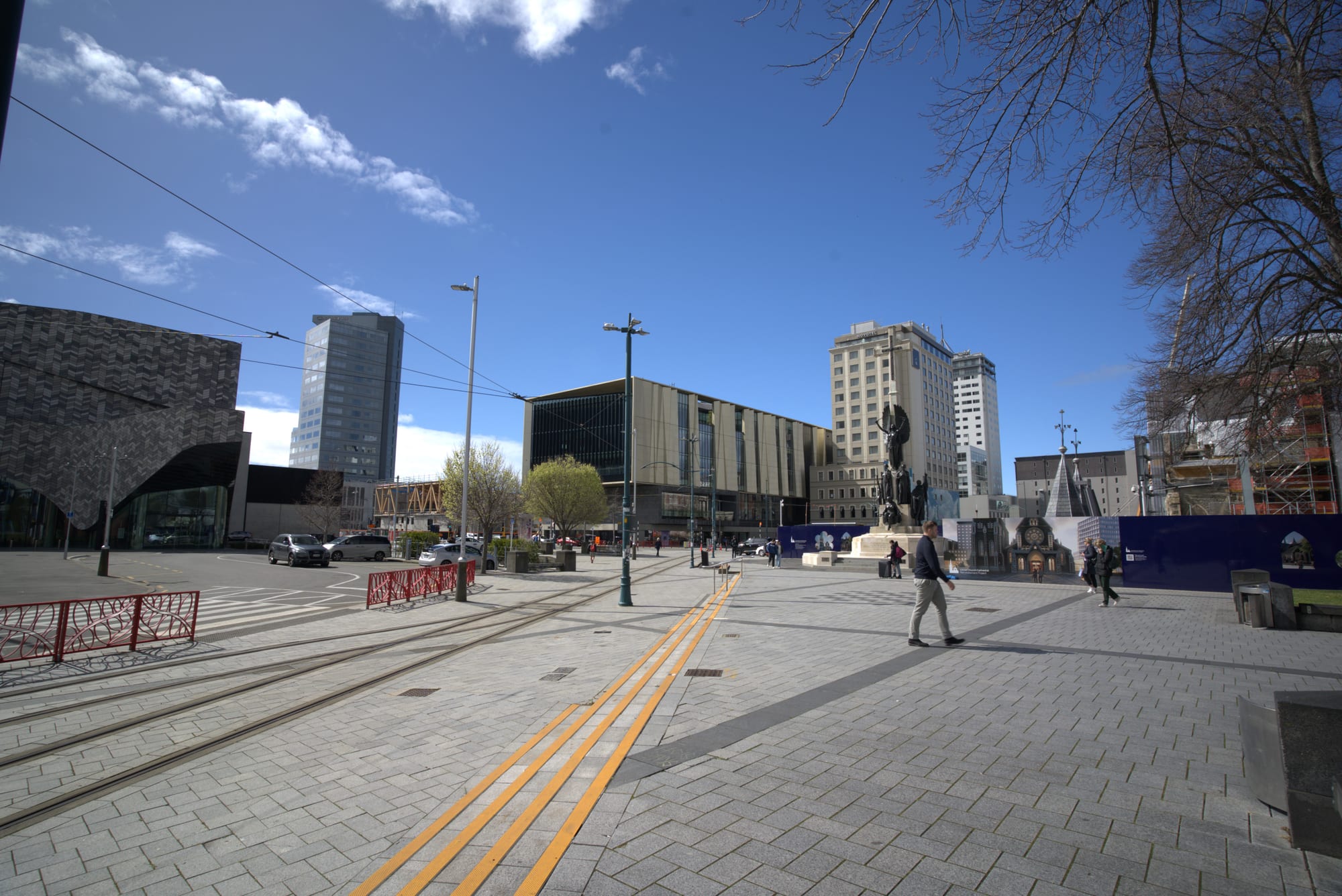
Tram tracks curving across a paved city square past modern stone and glass buildings under a bright blue sky

Christchurch, Canterbury & the Chathams, New Zealand

Christchurch

Tram tracks in the rebuilt centre of Christchurch, by the Tūranga library and the convention centre precinct. (Yvanyblog / Wikimedia Commons · CC BY-SA 4.0)

The largest city of New Zealand's South Island, laid out on flat land between the Port Hills and the Pacific in 1850 as a planned Anglican settlement. Known for its gardens, the Avon River and its English-looking heritage, it lost much of its centre to the earthquakes of 2010 and 2011 and has spent the years since rebuilding, with new public buildings, wide green spaces and street art.

Neighbourhoods

  • Central City
    • First-time visitors
    • Museums
    • Close to public transport

    The square inside the Four Avenues, rebuilt since the earthquakes around Cathedral Square, the Avon River and new buildings such as the Tūranga library and the convention centre. Hotels, galleries, the tram loop, laneway bars and the Riverside Market are all within walking distance, with the Botanic Gardens at the western edge.

    Open in Maps
  • Riccarton
    • Shopping
    • Students
    • Best for food

    A busy suburb west of the centre built around a large shopping centre, the University of Canterbury's neighbouring student quarter and a long strip of Asian restaurants and supermarkets on Riccarton Road. Riccarton House, the Deans family homestead of the 1850s, and a remnant of the original Canterbury forest stand in its middle.

    Open in Maps
  • Merivale and St Albans
    • Quiet and residential
    • Cafés

    Leafy streets of villas and gardens just north of Hagley Park, with a small shopping village of cafés, boutiques and restaurants. Among the most sought-after addresses in the city, and an easy walk or short bus ride from the centre.

    Open in Maps
  • Addington
    • Nightlife
    • Sport
    • Best for food

    A former railway workers' suburb south-west of the centre, now a strip of bars, breweries and restaurants along Lincoln Road beside the rugby ground, an indoor arena and the harness racing track. Busy on event nights and quiet by day.

    Open in Maps
  • Sumner
    • Beaches
    • Cafés
    • Quiet and residential

    A seaside village about twelve kilometres east, under cliffs at the foot of the Port Hills, with a grey-sand surf beach, the Cave Rock landmark and a short main street of cafés and shops. Badly hit by rockfall in the earthquakes and since substantially rebuilt.

    Open in Maps
  • Lyttelton
    • Historic district
    • Best for food
    • Harbour views

    The port town over the Port Hills, reached by a road tunnel, where the first organised settlers landed in 1850. Steep streets of timber cottages look down on container wharves and cruise ships, and the main street holds pubs, cafés and small shops.

    Open in Maps
  • New Brighton
    • Beaches
    • Local life

    An eastern suburb on the long open coast, marked by a pier reaching out over the surf and a set of hot saltwater pools beside the sand. The wider east suffered the worst earthquake damage, and its rebuilt shorefront has become a weekend gathering place.

    Open in Maps

Things to do

Famous landmarks

  • Cathedral Squarelandmark

    The city's central square, set out in the original 1850 plan, with the damaged ChristChurch Cathedral on one side and the tram running across it.

    Open in Maps
  • ChristChurch Cathedrallandmark

    The Anglican cathedral built between 1864 and 1904, whose spire fell in the 2011 earthquake; a decision to reinstate it was taken in 2017, and staged reinstatement work begun in 2026 is due to finish by 2030.

    Open in Maps
  • Cardboard Cathedrallandmark

    The transitional cathedral designed by Shigeru Ban and opened in 2013, built around large cardboard tubes and used for services and concerts.

    Open in Maps
  • New Regent Streetlandmark

    A short pedestrian street of pastel Spanish Mission shopfronts from 1932, restored after the earthquakes and lined with cafés and small bars.

    Open in Maps
  • Bridge of Remembrancelandmark

    A memorial arch over the Avon River, unveiled on Armistice Day 1924 for the dead of the First World War, at the head of the Cashel Street shopping strip.

    Open in Maps
  • Arts Centreattraction

    The Gothic Revival stone quadrangles of the former university and boys' high school, restored over many years and now holding galleries, studios, shops and eating places.

    Open in Maps
  • Christchurch tramwayattraction

    Restored heritage trams running a loop through the central city past the square, the Arts Centre and New Regent Street.

    Open in Maps

Museums and galleries

  • Canterbury Museummuseum

    The regional museum, known for its Māori and moa collections and its Antarctic exploration galleries; its Rolleston Avenue building beside the Botanic Gardens is being redeveloped, and a smaller museum runs in the Centre of Contemporary Art building.

    Open in Maps
  • Christchurch Art Gallerymuseum

    The city's public art gallery, opened in 2003 in place of the Robert McDougall Art Gallery, showing New Zealand and international art alongside its own substantial collection.

    Open in Maps
  • Tūrangaattraction

    The central library opened in October 2018 on Cathedral Square, with reading rooms, exhibition space and views over the rebuilt centre.

    Open in Maps
  • International Antarctic Centremuseum

    A visitor attraction beside the airport, next to the base that supports New Zealand, United States and Italian Antarctic programmes, with a cold room and storm simulator.

    Open in Maps
  • Air Force Museum of New Zealandmuseum

    The national air force museum at Wigram, on a former airfield south-west of the centre, with restored aircraft in large hangars.

    Open in Maps

Parks, gardens and the river

  • Christchurch Botanic Gardenspark

    Gardens founded in 1863 in a loop of the Avon River, with rose and rock gardens, glasshouses and very large exotic trees.

    Open in Maps
  • Hagley Parkpark

    The large public park that wraps around the Botanic Gardens, set aside by the provincial government in 1855 and the city's largest open space, used for cricket at Hagley Oval, running and festivals.

    Open in Maps
  • Avon River / Ōtākaroattraction

    The slow, willow-lined river that winds through the centre, punted from the Antigua Boat Sheds and followed by a riverside promenade built during the rebuild.

    Open in Maps
  • Orana Wildlife Parkattraction

    An open-range zoo on the city's western edge, home to New Zealand species and to African animals in large paddocks.

    Open in Maps

Beaches, hills and viewpoints

  • Christchurch Gondolaviewpoint

    A cable car climbing the Port Hills above Heathcote to a summit station with views over the city, Lyttelton Harbour and Banks Peninsula.

    Open in Maps
  • Port Hillsviewpoint

    The old volcanic ridge along the city's southern edge, crossed by the Summit Road and by walking and mountain-biking tracks.

    Open in Maps
  • Sumner Beachbeach

    A popular surf beach of fine grey sand below the cliffs, with the village behind it and the rock outcrop of Cave Rock on the shore.

    Open in Maps
  • New Brighton Pierlandmark

    A concrete pier reaching out over the breakers on the long eastern beach, with hot pools and a library beside it.

    Open in Maps

Short trips from the city

  • Lytteltonneighborhood

    The harbour town on the far side of the Port Hills, the landing place of the first four settler ships and now the city's port.

    Open in Maps
  • Akaroaattraction

    A harbour village on Banks Peninsula about ninety minutes away, settled by the French in 1840, with harbour cruises to see Hector's dolphins.

    Open in Maps
  • Banks Peninsulaattraction

    The eroded volcanoes and radiating bays south-east of the city, with hill roads, small settlements and walking tracks.

    Open in Maps
  • Arthur's Pass National Parkpark

    Alpine country in the Southern Alps reached by road or by the TranzAlpine train, with beech forest, waterfalls, kea and day walks.

    Open in Maps

Seasonal events

  • New Zealand Agricultural ShowNovember

    The country's largest agricultural and pastoral show, held over several days with thousands of livestock, competitions and hundreds of trade exhibitors, and coinciding with a week of major horse racing in the city.

  • MatarikiJune or July

    The Māori new year, marked by the rising of the Pleiades and observed in the city with dawn ceremonies, lights, food and community events.

  • Cricket at Hagley OvalDecember to February

    International and domestic cricket is played on the tree-ringed ground in Hagley Park through the southern summer.

Eat and drink

Long-standing places and food districts in Christchurch. Hours, ratings and directions come from your maps app, always current.

Christchurch classics

  • Riverside Marketmarket

    A food hall on Oxford Terrace in the central city, opened in 2019, with market stalls and small kitchens on the ground floor and bars and restaurants above.

    Open in Maps
  • New Regent Streetneighborhood

    A pedestrian street of small cafés, wine bars and bakeries under pastel arcades, with the tram passing through.

    Open in Maps

Food districts

  • Victoria Streetneighborhood

    A restaurant strip at the northern edge of the centre, with a long-established cluster of dining rooms, bars and hotels.

    Open in Maps
  • Riccarton Roadneighborhood

    The city's main Asian food street, with Chinese, Korean, Vietnamese, Malaysian and Japanese restaurants, bubble tea shops and grocers serving a large student population.

    Open in Maps
  • Addingtonneighborhood

    Lincoln Road's breweries, bars and casual restaurants, busy before and after events at the nearby stadium.

    Open in Maps
  • Sumner villageneighborhood

    Beachfront cafés, fish and chip shops and a few restaurants on the seaside village's short main street.

    Open in Maps

Experience Christchurch

History

Ngāi Tahu and earlier iwi knew the swampy plain between the Port Hills and the sea as Ōtautahi, with seasonal camps for eel, flounder and bird catching along the Ōtākaro and Ōpāwaho rivers and a major settlement at Kaiapoi to the north. Whalers and sealers used Lyttelton Harbour from the 1830s, and a mixed community of Europeans and Māori traded there before organised settlement began.

In 1850 the Canterbury Association, an Anglican colonising body, landed its first settlers from four ships at Lyttelton; they walked over the Bridle Path across the Port Hills to the site of a planned church city, named after Christ Church, Oxford. The grid within four broad avenues, the reserved parkland of Hagley Park, the cathedral in a central square and a college and gardens were laid out from the start. Wool from the Canterbury runs, grain from the plains and frozen meat exports from the 1880s made the city rich, and it was granted city status in 1856.

Christchurch grew steadily through the twentieth century as the South Island's commercial capital and the staging point for Antarctic expeditions, from Scott and Shackleton to today's research programmes. On 4 September 2010 a magnitude 7.1 earthquake shook the region, and on 22 February 2011 a shallower shock killed 185 people and destroyed much of the centre, including the cathedral's spire and the Canterbury Television building. Thousands of buildings were demolished and whole eastern suburbs abandoned. The rebuild that followed produced new civic buildings, a riverside promenade and wide gaps still filling in. On 15 March 2019 a gunman attacked two of the city's mosques, killing 51 people, an event that changed New Zealand's gun laws and left a deep mark here.

Culture & Customs

For a century Christchurch was called the most English city in New Zealand: Anglican foundations, private schools, punts on the Avon, cricket in Hagley Park and a reserved, slightly formal manner. Some of that survives in the gardens and the stone Gothic Revival buildings, and the city still competes for the title of garden city, with an open garden season and thousands of private plots.

The earthquakes changed the culture as much as the skyline. In the years of empty sites, temporary galleries, container shops, pop-up bars, gap-filler art projects and a great deal of street art appeared, and the rebuilt centre has kept a younger, more informal and more experimental tone than the old one. Large murals are now a recognised part of the city's identity, mapped and visited in their own right.

Sport is central. Rugby draws big crowds for the Crusaders, the most successful team in Super Rugby's history, and a 25,000-seat stadium opened in the central city in 2026; cricket is played at Hagley Oval; and netball, harness racing and the November racing carnival draw big crowds. Antarctic connections give the city an unusual international layer, with researchers passing through each austral summer. Ngāi Tahu, since its 1998 treaty settlement one of the region's largest commercial entities, has raised the visibility of Māori language, design and place names, and the city's Pasifika, Asian and refugee communities have added festivals, churches and food streets of their own.

Daily Life

About 400,000 people live in the city, making it the second-largest urban area in New Zealand and the service centre for the whole South Island. The economy rests on farming and food processing across the Canterbury plains, along with health, education, tourism, technology, aerospace and construction — the last still shaped by more than a decade of rebuilding. The airport and the port at Lyttelton handle much of the island's freight.

Housing is mostly detached and single-storey, spreading far across flat land, though the rebuild added apartments and townhouses in and near the centre. The eastern suburbs, worst affected by liquefaction, lost thousands of homes; much of that land is now a green corridor along the Ōtākaro, while growth has moved west and north into Rolleston, Rangiora and Kaiapoi, turning the plains into commuter country.

Daily life is flat and unhurried: children cycle to school, families drive to netball and rugby on Saturday, and weekends go to the beach at Sumner or New Brighton, the Port Hills tracks or the ski fields and lakes inland. Current local issues include the cost and supply of housing, the slow filling of remaining central-city sites, water quality and irrigation on the plains, transport choices in a low-density city, and the long-term insurance and resilience questions the earthquakes left behind.

Food

Canterbury's farmland supplies the city's kitchens, and lamb is the signature meat, along with high-country beef and merino. Salmon farmed in the hydro canals of the Mackenzie Basin, blue cod and groper from the coast, mussels and crayfish from Banks Peninsula, and whitebait fritters in their short river season make up much of the seafood. Bluff oysters arrive from the far south when the season opens in March and are treated as a delicacy.

Market halls and food streets carry the everyday eating. The Riverside Market in the centre, a food hall opened in 2019, puts market stalls next to small kitchens and bars; Riccarton Road is the city's Asian eating strip, reflecting a large student and migrant population; and weekend farmers' markets sell Canterbury cheese, bread, berries and stone fruit. Craft breweries work in the inner suburbs, and the Waipara Valley an hour north supplies pinot noir and riesling to city wine lists.

New Zealand staples are eaten here as everywhere: the bakery mince or steak pie, the flat white with a slice, fish and chips eaten on a beach wall, and the sausage sizzle outside a hardware shop. South Island specialities turn up too, notably the cheese roll, a rolled slice of toasted bread with a savoury cheese and onion filling, and hokey pokey ice cream, vanilla studded with toffee. Pavlova and Afghan biscuits appear at family gatherings, and hāngī, food steamed in an earth oven, is prepared for marae and community occasions.

Planning tools

Budget

Christchurch is one of the better-value larger cities in New Zealand, with cheaper hotel rooms and rents than Auckland or Queenstown and a good spread of hostels and motels. Many of its attractions — the Botanic Gardens, Hagley Park, the art gallery, the riverside walks and the beaches — cost nothing. Prices rise around big sporting events, concerts and the November show week.

Daily Budget Midrange
USD 150–290 (central hotel or motel, restaurant meals, a hire car, the gondola or a punt)
Daily Budget Shoestring
USD 55–90 (hostel bed, supermarket and market food, city buses and walking)

Bus fares are low and paid by contactless card, and a day in the gardens, the gallery and along the Avon can be done for the price of lunch.

Best Time to Visit

October to April is the warmest and driest stretch, with long evenings, cricket in Hagley Park and the gardens at their best; the show and festival week in November and the settled weather of February and March are particular draws. Winter is cold and frosty but often clear, and gives access to Canterbury's ski fields within a couple of hours.

Suggested Number of Days

Two or three days is the usual length for the central city, its museums, gardens and a beach. Four to six suits travellers adding day trips to the peninsula, the coast and the mountains inland, and anyone who prefers a slower pace without a car.

First Visit
2–3 days
With Surroundings
4–6 days

Transportation

A network of Metro buses radiates from a central bus interchange and reaches the suburbs, the beaches and Lyttelton, with fares paid by contactless card or phone through the national Motu Move system. The heritage tram is a sightseeing loop rather than transport. The city is famously flat, so cycling is popular and there are protected cycleways; taxis, ride-hailing and hire cars are widely used, and parking in the rebuilt centre is mostly in buildings.

The Lyttelton road tunnel is the quick route to the port; cyclists must use the road over the hill or take a bus instead.

Airport & Station Connections

Christchurch Airport, about twelve kilometres north-west of the centre, is the South Island's main gateway, with domestic flights and services to Australia and the Pacific, reached in around twenty-five minutes by bus, taxi or car. Long-distance coaches serve the city, the Coastal Pacific train runs north to Picton and the TranzAlpine west to Greymouth, and cruise ships berth at Lyttelton over the hill.

Walkability

The centre is flat, gridded and easily walked: Cathedral Square to the Botanic Gardens takes about fifteen minutes, and the riverside promenades and laneways make pleasant routes. The city as a whole is very spread out, so the beaches, the hills and the outer suburbs need a bus, a bicycle or a car.

Safety

Christchurch is generally safe, with the usual big-city caution needed around bars late at night and for property left in parked cars. Natural hazards matter more: earthquakes remain possible, rockfall closed parts of the Port Hills after 2011, summer nor'westers bring high fire risk on the hills, and the open eastern beaches have rips and cold water.

Learn the earthquake drill of drop, cover and hold, swim between the flags at patrolled beaches, and check fire restrictions before going into the Port Hills in summer. Check current official travel advice before travelling.

Climate

A temperate climate, drier than most of New Zealand because the Southern Alps block the westerly rain. The nor'wester, a hot dry föhn wind off the Alps, makes summer days much warmer and occasionally reaches storm force, while a change of wind can drop the temperature sharply. Nights fall below freezing often in winter, there are about eighty days of ground frost a year, and snow falls on average three times. In the southern hemisphere summer falls in December–February.

Summer
warm and dry, with days averaging about 23°C in January and hotter in a nor'wester
Winter
cold and often clear, with days averaging about 11°C in July, frequent frosts and cold nights

Local Customs

Tipping is not expected and service charges are unusual. Dress is casual and understated, greetings are informal and first names are normal. Christchurch stands in the rohe of Ngāi Tahu, and Māori names such as Ōtautahi for the city and Ōtākaro for the Avon are in everyday official use. The earthquakes and the 2019 mosque attacks are treated with care in conversation, and memorials are places for quiet.

Ask before photographing people, remove shoes when entering a home or a marae, and note that alcohol requires identification and public drinking is restricted in the central city.

Common Payment Methods

The currency is the New Zealand dollar. Cards and contactless payment are accepted almost everywhere, including on buses through the Motu Move system, and a surcharge is sometimes added for credit cards. ATMs are common in the centre and the suburban malls, and cash is rarely needed beyond market stalls.