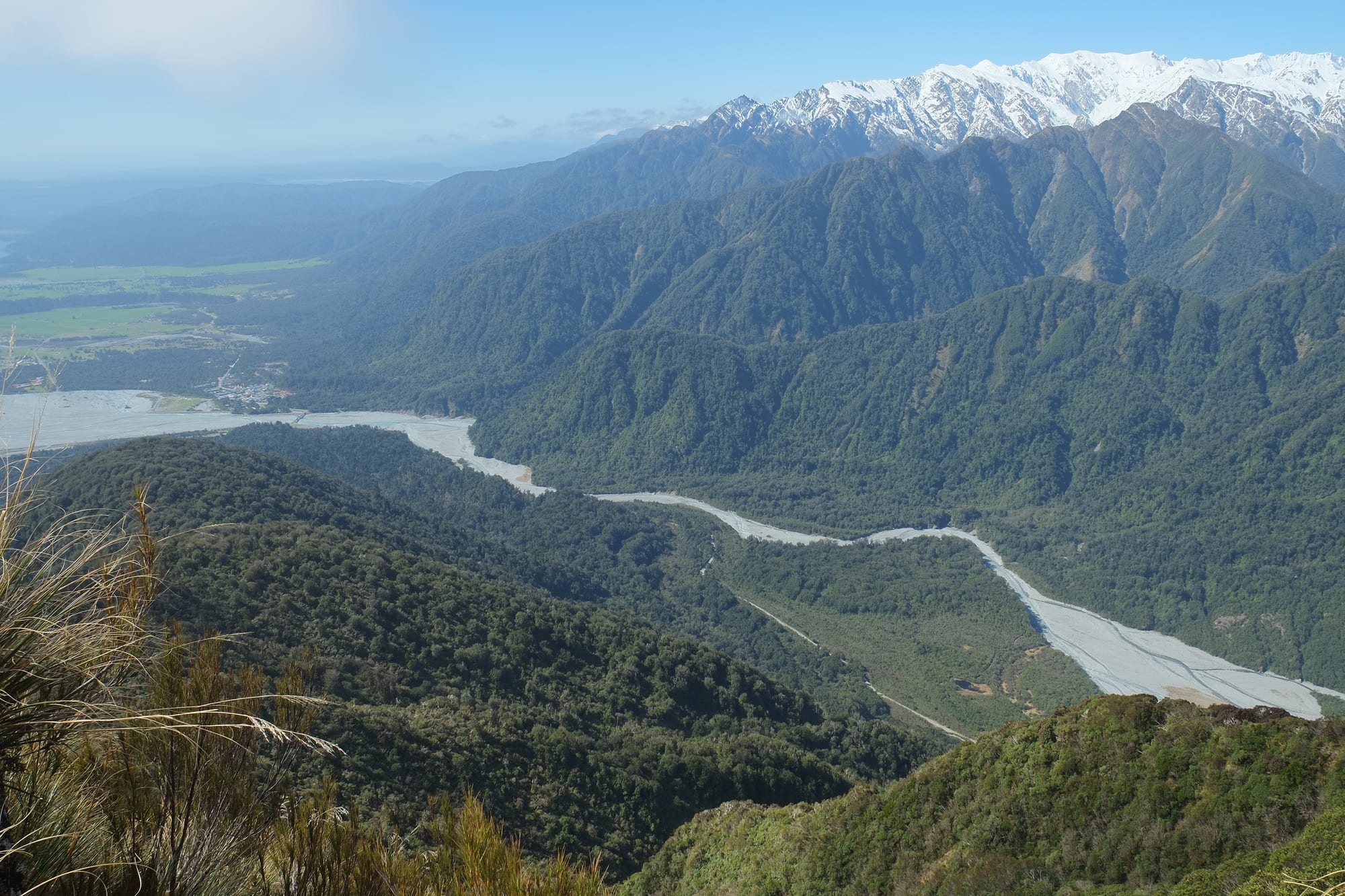
A wide grey braided riverbed winding between steep forested ridges towards snow-covered mountains, with a small settlement on the flats

Nelson, Marlborough & the West Coast, New Zealand

Franz Josef

The Waiho River valley and Franz Josef village seen from Alex Knob, with the Southern Alps behind. (Pseudopanax at English Wikipedia / Wikimedia Commons · Public domain)

A village of a few hundred people on the West Coast of New Zealand's South Island, strung along a single highway between rainforest, the braided Waiho River and the mountains of Westland Tai Poutini National Park. It exists for the glacier a few kilometres up the valley, known to Māori as Kā Roimata o Hine Hukatere, and for the helicopters, guides and walks that reach it.

Neighbourhoods

  • The village centre
    • First-time visitors
    • Best for food
    • Tour departures

    A few hundred metres of State Highway 6 holding the hotels, hostels, motels, restaurants, bars, guiding offices and the helicopter booking desks. Almost everything a visitor needs is within a five-minute walk, and the rainforest starts immediately behind the buildings.

    Open in Maps
  • The glacier valley road
    • Walks
    • Viewpoints
    • Quiet and residential

    The side road that leaves the highway south of the village and runs a few kilometres up the Waiho valley to the car park, with short tracks to lookouts, pools and gorge bridges branching off it. There is no accommodation up here, only bush, river flats and parked cars.

    Open in Maps
  • Ōkārito and the coast
    • Wildlife
    • Beaches
    • Quiet and residential

    A tiny former gold town on a lagoon about twenty-five kilometres north-west, at the end of a dead-end road, with a handful of cottages, a beach and kayaks on the water. It is the quiet alternative to the village for anyone more interested in birds than ice.

    Open in Maps

Things to do

The glacier and the park

  • Franz Josef Glacierattraction

    A steep glacier descending from the Southern Alps towards rainforest, reached by a valley walk to a viewpoint or by guided helicopter landing on the ice.

    Open in Maps
  • Westland Tai Poutini National Parkpark

    The national park running from the main divide to the sea, taking in glaciers, rainforest, lakes and beaches, and part of the Te Wāhipounamu World Heritage Site.

    Open in Maps
  • Waiho Riverattraction

    The grey, gravel-choked river draining the glacier, whose bed has risen over the years and whose floods have repeatedly damaged the highway and bridge.

    Open in Maps

Walks and lakes

  • Alex Knob Tracktrail

    An eight-hour day climb of some 1,100 metres through rainforest to a knob overlooking the glacier, the valley and the village.

    Open in Maps
  • Lake Wombat and Peters Pooltrail

    Two short walks off the glacier valley road, one to a small bush-fringed lake, the other to a pool that reflects the mountains on a still day.

    Open in Maps
  • Lake Mapourikapark

    A large dark lake about ten kilometres north, ringed by rainforest and used for kayaking and boat trips.

    Open in Maps
  • Ōkārito Lagoonattraction

    The largest unmodified coastal wetland in New Zealand, a shallow tidal lagoon rich in birdlife, paddled by kayak with the Alps in view on a clear day.

    Open in Maps

In the village

  • West Coast Wildlife Centreattraction

    A conservation centre and hatchery in the village that hatches and rears rowi and Haast tokoeka kiwi for release in the wild, with kiwi viewing and displays on the glaciers and West Coast history.

    Open in Maps

Short trips from the village

  • Fox Glacierattraction

    The second of the two Westland glaciers, about twenty-three kilometres south-west, with its own village, valley walk and flight operators.

    Open in Maps
  • Lake Mathesonattraction

    A small lake near Fox Glacier whose still surface reflects Aoraki / Mount Cook and Mount Tasman on calm mornings.

    Open in Maps
  • Gillespies Beachbeach

    A remote black-sand beach at the end of an unsealed road beyond Fox Glacier, with the remains of a gold-mining settlement and a track on to the fur seal colony at Galway Beach.

    Open in Maps

Eat and drink

Long-standing places and food districts in Franz Josef. Hours, ratings and directions come from your maps app, always current.

Franz Josef classics

  • West Coast whitebaitrestaurant

    In spring, whitebait netted in the coast's river mouths appears on village menus as a fritter bound with egg — the region's best-known dish.

    Open in Maps
  • Venison and West Coast beerrestaurant

    Farmed and wild venison, beef and lamb fill the pub and bistro menus, served with beer from West Coast and wider New Zealand breweries.

    Open in Maps

Food districts

  • The Main Road stripneighborhood

    The village's cafés, bakery, pizzeria, pub and restaurants line a short stretch of the highway, along with a small supermarket for self-caterers.

    Open in Maps
  • Fox Glacier villageneighborhood

    A smaller cluster of cafés, a pub and a store twenty-three kilometres south-west, useful when Franz Josef is full.

    Open in Maps

Experience Franz Josef

History

For Poutini Ngāi Tahu and earlier iwi, this coast was a route for pounamu, the greenstone carried out of the Arahura and other rivers and traded the length of the country. Tradition links the glacier to Hine Hukatere, a woman whose tears for a lost companion were frozen by the gods, giving the ice its name, Kā Roimata o Hine Hukatere. Travellers came through on foot along beaches and riverbeds rather than settling in the wet, forested valleys.

Europeans reached the glacier in the 1860s, during the West Coast gold rushes that filled the region with miners. The geologist Julius von Haast visited in 1865 and named it after Franz Joseph I, the Austrian emperor. A small settlement of hotel, store and guides grew up on the flats below, and by the early twentieth century guided ice walks in hobnailed boots were a set piece of New Zealand tourism. Road access improved through the 1930s, and the village became a scheduled stop on coach routes.

The glacier itself has shaped the village's fortunes. It advanced for much of the 1980s and 1990s, reaching close to the valley floor, then retreated quickly from about 2008, and rockfall from the unstable terminal area ended walk-in access to the ice face — since then, setting foot on the glacier has meant flying to it. Floods on the Waiho have repeatedly wrecked the bridge and riverworks, most severely in 2019, and the closure of borders during the pandemic emptied the village for a time. It has rebuilt around flights, guided walks and the wider rainforest and lake country.

Culture & Customs

Franz Josef is a working tourist village, and that shapes almost everything about it. Most of the people living there at any time are guides, pilots, mechanics, cooks, cleaners and receptionists, many of them young and from elsewhere in New Zealand or overseas, staying for a season or two. Shifts, weather forecasts and flight schedules set the rhythm, and the bars fill after the last helicopter of the day.

Underneath sits the older West Coast culture of the region: descendants of mining and sawmilling families, a tradition of independence and scepticism about distant authority, hunting and whitebaiting seasons, and a strong habit of mutual help in a place where the nearest hospital is hours away. Conservation and tourism now provide the jobs that timber and gold once did, and arguments about how much development the national park and the river should carry are never far away.

The mountains and the ice are treated with respect for practical and cultural reasons. Guides brief visitors on why barriers exist, and the glacier's Māori name and story are part of that briefing. Weather is a constant subject of conversation, cancellations are accepted with resignation, and anyone who complains about rain on the West Coast is gently reminded that the rainforest exists for a reason.

Daily Life

Only a few hundred people live in Franz Josef permanently, and the figure rises and falls with the season as staff arrive for summer and leave in the quiet months. Housing is a mixture of small houses, staff quarters and rented units, much of it owned by the businesses themselves, and shortage of accommodation for workers is a long-standing constraint on the village.

Almost all employment is tourism: helicopter and fixed-wing operators, glacier guiding, hotels, hostels, cafés, the wildlife centre, the supermarket and the petrol station, along with Department of Conservation staff looking after tracks and huts. Farming continues on the flats north and south, and a few residents commute to Whataroa or Hokitika. Everything is trucked in along the coast highway, which makes prices high and supply vulnerable when a slip closes the road.

Daily life is simple and weather-led. The school is a small full primary, the medical centre limited, the nearest secondary school is at Hari Hari some sixty kilometres north, and larger shopping and specialists mean a long drive to Hokitika or Greymouth. Long-term concerns are the state of the Waiho River and the flood defences that protect the village, the future of the highway and bridge, seasonal staffing, and how a settlement of this size copes with hundreds of thousands of visitors a year.

Food

Eating in Franz Josef means a short, dependable list rather than a food scene: cafés serving big breakfasts, pies and flat whites before the first flights, pizzerias, a bakery, a pub and a few restaurants with venison, lamb, beef and fish. Portions are generous, because most customers have spent the day walking or are about to. Self-catering from the small supermarket is common among those staying in hostels and campsites.

The regional specialities are worth looking for. Whitebait, the tiny translucent young of native fish, are netted in West Coast river mouths in a short spring season and served in a fritter, usually with lemon and bread; they are a delicacy and priced like one. Venison and wild pork come from the surrounding hills, and the coast supplies blue cod, whitefish and, in places, crayfish.

Beyond that, the fare is standard New Zealand: fish and chips, meat pies, scones and slices, ice cream, and New Zealand wine and craft beer by the glass. Dairy farms on the coastal flats send milk to processing plants, so butter, cheese and cream are local in the broadest sense. Manuka and rata honey from the rainforest, and fudge and chocolate aimed squarely at visitors, fill the shelves of the village shops.

Planning tools

Budget

For a village this size, prices are high: beds are limited, demand is concentrated in summer, and food and fuel carry the cost of long supply routes. The single biggest expense is a helicopter flight or a guided heli-hike onto the ice, which costs several hundred dollars a person. The valley walks, lookouts and rainforest tracks are free, and there is hostel and campsite accommodation as well as hotels.

Daily Budget Midrange
USD 150–290 (motel or lodge, restaurant meals, a hire car, a guided walk or short tour)
Daily Budget Shoestring
USD 60–100 (hostel bed or campsite, supermarket food, valley and rainforest walks)

Book beds and any flight well ahead for December to February, and treat a flight as weather-dependent by allowing spare time in the plan.

Best Time to Visit

There is no dry season, only better odds. December to March is warmest and busiest; late summer and autumn often bring more settled spells. Winter days can be cold, still and startlingly clear, which suits flights and mountain views, though the village is quiet and some businesses cut their hours. Rain falls in every month.

Suggested Number of Days

One night is enough for the valley and a look at the ice; two or three allow a longer walk, the lakes and the coast, and give a second chance if cloud grounds the helicopters. Many visitors pass through in a day while driving the coast.

First Visit
1–2 days
With Surroundings
3 days

Transportation

The village is small enough to walk end to end in ten minutes. The glacier car park is about five kilometres away up the valley road, and shuttles run there in season; otherwise a car is needed, and most people arrive driving State Highway 6. Long-distance buses between Greymouth, Queenstown and Christchurch stop in the village daily, and guides and flight operators collect passengers from accommodation.

Fuel is expensive and stations are far apart on the coast, so tanks are best filled in the larger towns; check road status after heavy rain.

Airport & Station Connections

Franz Josef lies on the West Coast highway, roughly two hours south of Hokitika, under three hours from Greymouth and five to six hours from Queenstown over the Haast Pass, with Christchurch five to six hours away via Arthur's Pass. Coaches run daily in summer. There is no scheduled airline service; the village heliport handles sightseeing flights rather than transport.

Walkability

The village itself is completely walkable, since it is essentially one street with footpaths, and rainforest tracks begin at its edge. Beyond that distances are long: the glacier car park is a few kilometres up the valley and the lakes and coast much further, so walking is for the tracks rather than for getting about. Paths can be muddy and slippery after rain.

Safety

The village is safe, with theft from parked cars at trailheads the main crime. The natural hazards are serious and well signposted: rockfall and ice collapse near the glacier terminal, sudden floods in the Waiho and side creeks, slips that close the highway, and cold, exposed conditions on the high tracks. The Alpine Fault runs close by, and sandflies are constant in the bush.

Stay behind the barriers in the glacier valley and never approach the ice face on foot, treat river crossings after rain as impassable, carry warm and waterproof layers on any track, take insect repellent, and follow instructions from guides and flight crews. Check current official travel advice before travelling.

Climate

One of the wettest inhabited places in New Zealand, where westerly winds lift moist air against the Southern Alps and drop several metres of rain a year. Temperatures are mild for the latitude, frost is light at village level, and snow falls only on the mountains. Clear days come between fronts and are often the calmest and coldest. Summer runs from December to February in the southern hemisphere.

Summer
mild and wet, with daytime highs usually around 19–22°C and heavy rain between sunny spells
Winter
cool and wet, with daytime highs around 11–13°C, cold clear spells and snow on the peaks

Local Customs

Dress is practical and informal, and boots and rain jackets are normal attire in restaurants. Tipping is not expected. West Coasters value self-reliance and plain speaking, and small businesses run on limited staff, so patience helps. The glacier and the surrounding land hold deep meaning for Poutini Ngāi Tahu, whose tradition tells of Hine Hukatere's tears freezing into the ice, and pounamu from the region is treated as a taonga.

Photo identification is asked for when buying alcohol. Drones are restricted in the national park and around the heliports, and permission should be sought before photographing people or marae.

Common Payment Methods

The currency is the New Zealand dollar, and cards and contactless payment are taken by hotels, tour operators, shops and restaurants, sometimes with a surcharge. There is very limited banking in the village, mobile coverage and internet can be patchy along the coast, so a small amount of cash is sensible as a backup.