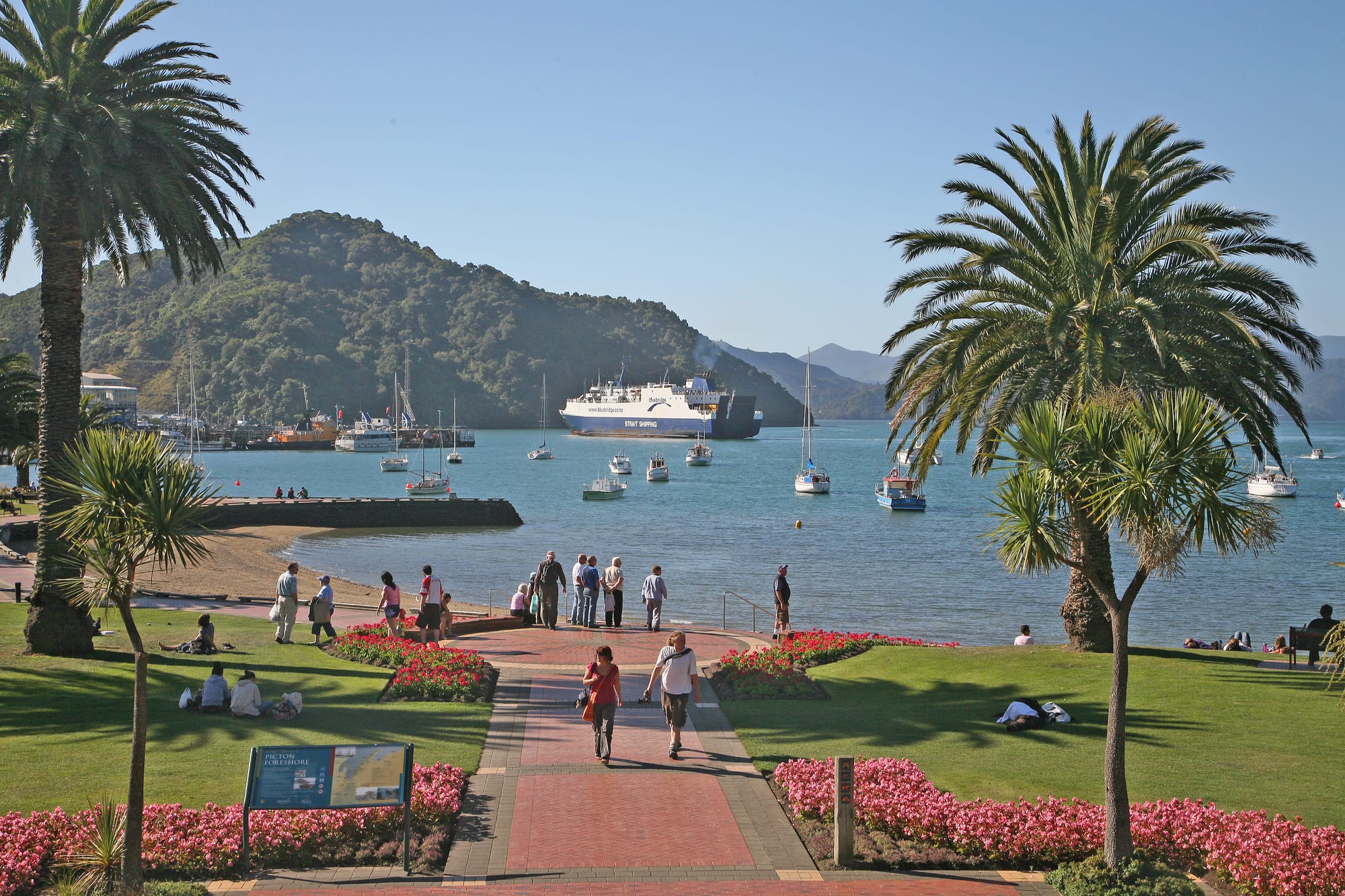
Palm trees and flower beds on a green foreshore above a blue harbour, with a ferry and moored yachts below wooded hills

Nelson, Marlborough & the West Coast, New Zealand

Picton

The foreshore at Picton, looking down Queen Charlotte Sound past a Cook Strait ferry. (W. Bulach / Wikimedia Commons · CC BY-SA 4.0)

A small port town at the head of Queen Charlotte Sound, in the north-east corner of New Zealand's South Island. Known to Māori as Waitohi, it briefly served as the capital of Marlborough Province before losing that role to Blenheim. Today it lives on the Cook Strait ferries, the Coastal Pacific railway and boat trips into the Marlborough Sounds.

Neighbourhoods

  • The foreshore and town centre
    • First-time visitors
    • Close to public transport
    • Best for food

    A few flat blocks between the ferry terminal and the harbour lawn, where High Street and London Quay hold the cafés, pubs, tour desks and most of the shops. Almost everything a visitor needs is within a five-minute walk of the water, and the railway station and bus stops sit beside the wharves.

    Open in Maps
  • Waikawa
    • Boating
    • Quiet and residential

    A residential bay on the far side of the hill from the town centre, a couple of kilometres by road, built around Waikawa Marina, one of the largest in the country with some 600 berths. Yachts, charter boats and a long-established Māori community share the shoreline, and the bay is the starting point for several harbour walks.

    Open in Maps
  • Victoria Domain and the Snout
    • Walks and viewpoints
    • Quiet and residential

    The wooded ridge that separates the town from Waikawa, laid out with tracks through regenerating bush to lookouts over the Sound. Houses climb the lower slopes on steep streets; higher up there is only forest, birdsong and views down the drowned valley towards Cook Strait.

    Open in Maps
  • The Sounds bays
    • Nature and wildlife
    • Quiet and residential

    Beyond the town the coastline breaks into dozens of bays reachable only by boat or by long gravel roads. Lodges, holiday cottages and a scattering of permanent residents rely on the water taxis and the mail boat that runs out of Picton, and mussel farms line many of the sheltered arms.

    Open in Maps

Things to do

On the water

  • Queen Charlotte Sound / Tōtaranuiattraction

    The long drowned river valley that Picton sits at the head of, explored by water taxi, kayak, mail boat and cruise past forested ridges and sheltered bays.

    Open in Maps
  • Motuara Islandattraction

    A predator-free island bird sanctuary near the outer Sound, reached by boat, where South Island saddlebacks and other rare birds can be seen along a short summit track.

    Open in Maps
  • Meretoto / Ship Coveattraction

    The sheltered cove in the outer Sound that James Cook used as a base on his Pacific voyages, now marked by memorials and served by the same boats that drop walkers at the track.

    Open in Maps
  • Marlborough Soundsattraction

    The wider maze of flooded valleys and islands stretching west from Picton towards Havelock, one of the country's main cruising and mussel-farming grounds.

    Open in Maps

Walks, heritage and the town

  • Queen Charlotte Tracktrail

    A walking and mountain-biking route along the ridges and bays between Meretoto / Ship Cove and Anakiwa, three to five days end to end, usually reached by boat from Picton and walked in sections.

    Open in Maps
  • Edwin Foxmuseum

    The hull of a merchant ship built of teak in Calcutta in 1853, the only surviving ship to have carried convicts to Australia, preserved in a dry dock museum near the waterfront.

    Open in Maps

Short trips from the town

  • Blenheimneighborhood

    The Marlborough wine town on the Wairau plains, under half an hour south by road, with cellar doors among more than fifty vineyards and the Omaka aerodrome, home of the two-yearly Classic Fighters airshow.

    Open in Maps
  • Havelockneighborhood

    A small settlement at the head of Pelorus Sound reached by the winding Queen Charlotte Drive, known for green-lipped mussels and boat trips.

    Open in Maps
  • Pelorus Riverattraction

    A clear, boulder-strewn river west of Havelock, known for swimming where it runs through a gorge at the Pelorus Bridge Scenic Reserve, with forest walks and camping.

    Open in Maps
  • Kaikōuraattraction

    A coastal town about two hours south, where a deep trench close inshore brings sperm whales, dolphins and seals within reach of boat trips.

    Open in Maps

Eat and drink

Long-standing places and food districts in Picton. Hours, ratings and directions come from your maps app, always current.

Picton classics

  • High Street and London Quayneighborhood

    The town's short main street and the quay facing the harbour hold most of its cafés, bakeries, pubs and seafood restaurants, many with tables looking out at the ferries.

    Open in Maps
  • Marlborough green-lipped musselsrestaurant

    Mussels farmed in the surrounding Sounds appear steamed, in chowder and in fritters on menus throughout the town, often alongside locally farmed king salmon.

    Open in Maps
  • Waikawa Marinaneighborhood

    A small cluster of eating places among the boats at Waikawa, a short drive or walk over the hill from the centre.

    Open in Maps

Nearby food and wine

  • Havelock mussel restaurantsneighborhood

    The village at the head of Pelorus Sound built its reputation on green-shell mussels, served in its handful of pubs and cafés.

    Open in Maps
  • Wairau Valley cellar doorsneighborhood

    The vineyards around Blenheim, half an hour south, pair tastings of sauvignon blanc and pinot noir with vineyard kitchens and platters.

    Open in Maps

Experience Picton

History

The flat land at the head of the Sound was long occupied by Māori, who knew the place as Waitohi; the sheltered harbour gave access to fishing grounds and to the crossing of Cook Strait. In January 1770 James Cook anchored about thirty kilometres down the Sound at Meretoto / Ship Cove, which he used on that and five later visits as a base for repairs, water and observation, making the outer Sound one of the earliest and most frequently visited European anchorages in the country.

European settlement followed the purchase of the land from Te Āti Awa in 1850, after which its people moved to neighbouring Waikawa Bay, and the town that grew there was renamed after Sir Thomas Picton, a British general killed at Waterloo. When Marlborough separated from Nelson as its own province in 1859, Picton became its capital, but the rivalry with Blenheim on the plains was quickly lost and the seat of government moved there in 1865. The harbour kept the town alive instead: timber, wool and produce were shipped out, and whaling and later mussel farming worked the surrounding waters.

The railway ran south from Picton to just north of Blenheim from 1875, but the line through to Christchurch was not completed until 1945. The decisive change came in 1962, when a rail and road ferry service began across Cook Strait between Wellington and Picton, joining the two islands' road and rail networks for the first time and turning the town into a national transport hinge. Tourism followed as the Marlborough Sounds became a destination in their own right, and Picton's population and its port facilities have grown steadily around the terminal ever since.

Culture & Customs

Picton's identity is that of a port and a gateway: a town where a large share of the working day is timed to ferry sailings, and where the population swells and shrinks with each arrival. The rhythm gives the place a cheerful, transient surface — tour desks, cafés, luggage on the footpath — over a small permanent community that knows everyone. Many residents work in tourism, on the ferries, in the port or on the water, and boats are treated less as leisure objects than as ordinary transport.

Māori connections run deep. Waikawa Bay, just over the hill, has a marae and a long-settled community with ties to the iwi of Te Tau Ihu, the top of the South Island, and the Sound carries the official dual name Queen Charlotte Sound / Tōtaranui in recognition of that history. Place names, carvings and interpretation panels around the foreshore tell both the Māori and the European story of the harbour.

Cook's visits are the other thread of local memory, marked at Ship Cove and in the town's museums, and the arrival of European ships is presented with more attention than it once was to what followed for Māori. Otherwise the culture is recognisably small-town New Zealand: a rugby club and bowling greens, a summer of fishing competitions, boat races and barbecues, a Christmas period when the foreshore lawn fills with families, and a winter when the town returns to itself.

Daily Life

About 4,800 people live in Picton and neighbouring Waikawa, with more in the bays of the Sounds. The port is the largest employer, directly and through the trucking, rail and logging traffic it generates; tourism, aquaculture, boat building and marine services provide much of the rest. Forestry trucks and log stacks are as much a part of the waterfront as the yachts, and mussel and salmon farms in the Sounds send produce out through the town.

Housing climbs the hillsides in streets of weatherboard bungalows, with newer subdivisions towards Waikawa. The town has schools, a medical centre and a supermarket, but specialist shopping, hospital care and secondary services mean a drive to Blenheim, and a longer trip to Nelson or a flight for anything more. Many households keep a boat, and access to the water shapes where people choose to live.

The daily pattern is set by the timetable across the strait: the first sailings before dawn, the shops busy when passengers walk off, then quiet stretches in between. Local concerns include the redevelopment of the ferry terminal and the condition of the ships serving the crossing, the pressure that holiday homes and short-term letting put on housing for workers, the sustainability of the mussel and log trades, and the state of narrow Sounds roads after storms.

Food

Seafood is the mainstay. Green-lipped mussels, farmed on long lines throughout the Marlborough Sounds, appear steamed in wine and garlic, in chowder and in fritters; king salmon raised in the same cold currents is smoked, cured or grilled; and blue cod, snapper and gurnard from local boats fill the fish and chip shops on the waterfront. Scallops and pāua, an abalone with a dark iridescent shell, are seasonal treats governed by strict catch rules, and crayfish comes up the coast from Kaikōura.

Marlborough's vineyards begin a few kilometres inland, so the wine list in a Picton restaurant is short on distance: sauvignon blanc with the region's characteristic sharpness, along with pinot noir, chardonnay and traditional-method sparkling wine from the Wairau and Awatere valleys. Craft beer from Nelson and Blenheim breweries is widely poured, much of it made with hops grown in the Nelson district.

Everyday eating is simple and generous in the New Zealand country manner: the bakery pie, the flat white, fish and chips eaten on the harbour lawn, and pavlova or hokey pokey ice cream for dessert. Summer brings farmers' market produce from the Wairau plains — cherries, stone fruit, olive oil and cheese — and the barbecue culture that comes with long evenings, with whitebait fritters appearing in the short season when the tiny fish run in the river mouths of the top of the South Island.

Planning tools

Budget

Picton is a working port with a small range of accommodation, so prices rise sharply in January and February and around long weekends, when ferry passengers fill the motels. Food costs are typical for a New Zealand country town, with a supermarket in the centre. The main extras are boat transfers into the Sounds, kayak or bike hire, and the ferry crossing itself.

Daily Budget Midrange
USD 150–280 (motel or lodge, restaurant meals, a hire car, a boat trip into the Sounds)
Daily Budget Shoestring
USD 55–90 (hostel or holiday park, supermarket food, a harbour walk and the local bus)

Book beds and vehicle space on the Cook Strait ferries well ahead for December to February; walking a section of the Queen Charlotte Track and the Victoria Domain lookouts cost nothing.

Best Time to Visit

December to April brings the settled weather for boat trips, kayaking and the Queen Charlotte Track, with February and March usually the calmest and quieter than the school holidays. Spring and autumn are mild and much less crowded. Winter is cool and often bright, though some boat services and lodges run reduced schedules.

Suggested Number of Days

Most travellers pass through in a day around a ferry sailing, and a night or two is enough to add a boat trip. Three or four days allow the wider Sounds, the wine country to the south, or several sections of the long coastal track.

First Visit
1–2 days
With Surroundings
3–4 days

Transportation

The town centre is small enough to cross on foot in ten minutes, and the ferry terminal, railway station and coach stops are all beside the harbour. A hire car, campervan or shuttle covers the road south to Blenheim and the winding drive west to Havelock. Water taxis and the mail boat are the transport of the Sounds themselves, since most bays have no road at all.

Roads in the Sounds are narrow, unsealed in places and much slower than their distances suggest; allow far longer than a map implies.

Airport & Station Connections

Picton is the South Island end of the Cook Strait ferry crossing from Wellington, a passage of about three hours that ends with a long, sheltered run down Queen Charlotte Sound. The Coastal Pacific train runs south to Blenheim, Kaikōura and Christchurch in the warmer months, and long-distance coaches meet the sailings. The nearest airport is at Woodbourne near Blenheim, under half an hour away by road.

Walkability

The centre is flat, compact and easily walked, with the foreshore, shops, museums and terminals within a few hundred metres of each other. Beyond that the land climbs steeply, so the routes to Waikawa and the Snout are hill walks rather than strolls, and the bays of the Sounds are reached by boat.

Safety

Picton is a safe small town with little crime beyond occasional theft from cars parked at trailheads and car parks. The real hazards are on the water and in the bush: Cook Strait is exposed and can be rough, the weather in the Sounds changes quickly, and walkers on the coastal tracks need to carry water and tell someone their plans. The region lies in an earthquake zone.

Check marine forecasts before kayaking or small-boat trips, carry insect repellent for sandflies in the bays, and leave valuables out of sight in parked cars. Check current official travel advice before travelling.

Climate

Marlborough is among the sunniest and driest parts of New Zealand. Picton's sheltered position at the head of the Sound keeps it mild, though sea breezes pick up on summer afternoons and southerly changes can cool things quickly. In the southern hemisphere summer falls in December–February.

Summer
warm and sunny, with daytime temperatures usually around 20–25°C and long light evenings
Winter
cool and often clear, with days near 12–13°C, frosty mornings and rain arriving in spells

Local Customs

Tipping is not expected in New Zealand and service charges are unusual. Dress is informal, and greetings are first-name and relaxed; 'kia ora' is widely used. The town's Māori name is Waitohi, and Waikawa has a marae and an established Māori community — ask before entering marae grounds or photographing people. Shoes are often left at the door of a private home.

Alcohol is sold in licensed shops and supermarkets with identification required, and drinking in public places is restricted. Freedom camping is only allowed in signposted areas, and rubbish and waste must be carried out.

Common Payment Methods

The currency is the New Zealand dollar. Cards and contactless payment are accepted almost everywhere, including on boats and buses, and a surcharge is sometimes added for credit cards. ATMs are in the town centre but not in the Sounds, so carry some cash for remote lodges and small operators.