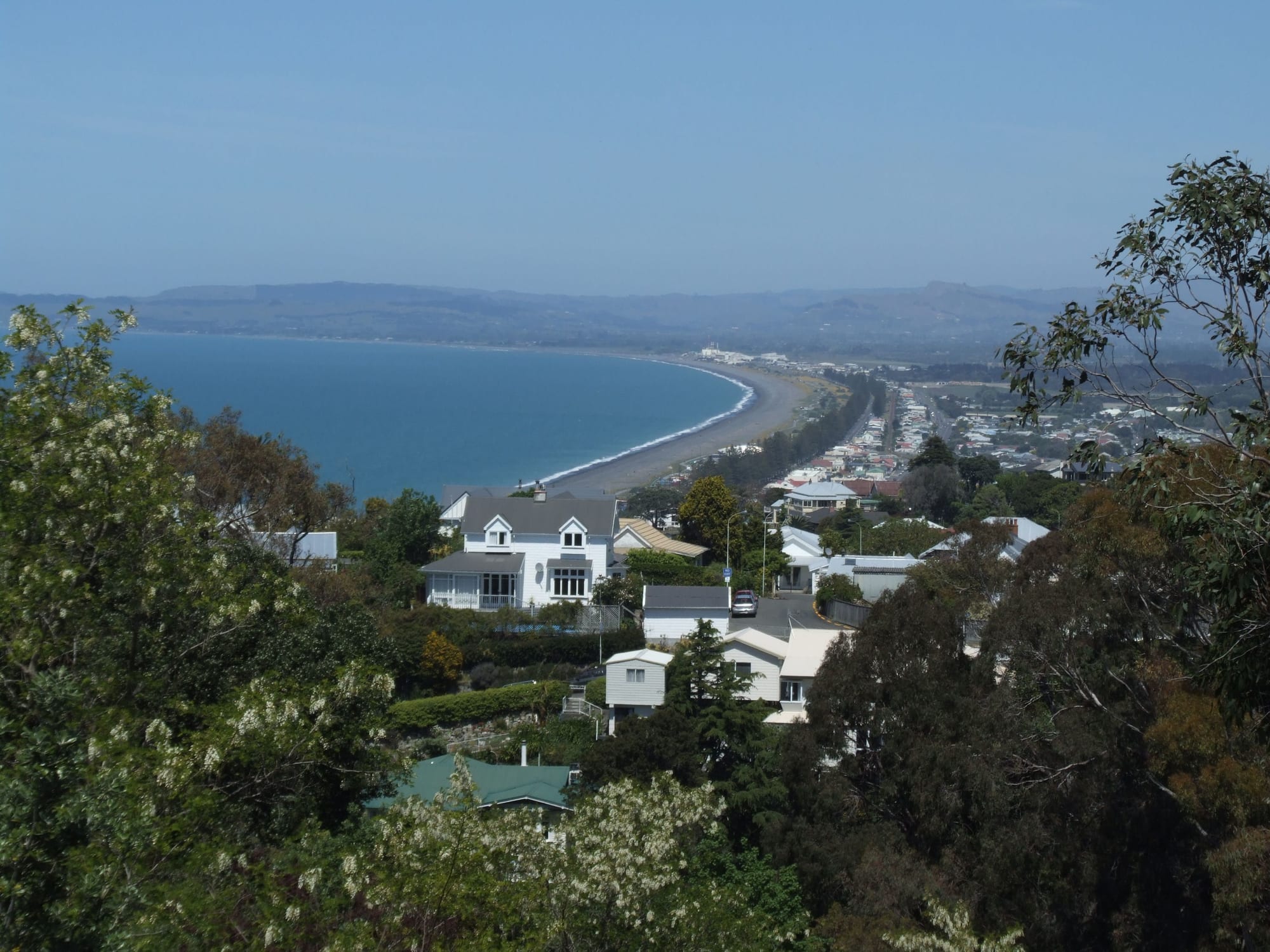
View from a wooded hillside over the roofs of Napier to a long grey beach curving along a blue bay

Wellington & the Lower North Island, New Zealand

Napier

Napier and the shingle shore of Hawke Bay, seen from the hill above the city. (Andrew McMillan / Wikimedia Commons · Public domain)

A port city on Hawke Bay, on New Zealand's sunny east coast, built around the hill of Mataruahou and the old Ahuriri lagoon. The Hawke's Bay earthquake of 1931 destroyed its centre, which was rebuilt within a few years in Art Deco and Spanish Mission styles. Today it lives on its port, fruit and wine country, and visitors drawn to those 1930s streets and the long seafront.

Neighbourhoods

  • The city centre and Art Deco quarter
    • First-time visitors
    • Architecture
    • Close to public transport

    The flat grid of streets between Marine Parade and Clive Square, rebuilt after 1931 and now holding a concentration of 1930s commercial architecture unlike any other New Zealand city. Emerson Street and Tennyson Street hold the shops, cafés and restaurants, and most of the city's hotels and motels are within a short walk of the seafront.

    Open in Maps
  • Marine Parade
    • Walks and gardens
    • Sea views
    • Families

    The long seafront boulevard, lined with Norfolk pines and a chain of gardens, fountains, a sound shell and lawns laid out after the earthquake. The aquarium stands at its southern end. The beach below is steep shingle with strong currents rather than a swimming beach.

    Open in Maps
  • Napier Hill
    • Historic homes
    • Viewpoints
    • Quiet and residential

    The limestone bluff above the centre, known in Māori as Mataruahou, where early European development was concentrated and the oldest surviving houses stand on narrow, winding lanes. Its Victorian and Edwardian villas contrast with the Art Deco town below, and the lookout at the top takes in the bay and the port.

    Open in Maps
  • Ahuriri
    • Best for food
    • Waterfront
    • Bars

    The old harbour district north-west of the hill, where the port began. Warehouses and wool stores along West Quay have become restaurants, bars and offices, and the inner harbour is used by small boats.

    Open in Maps
  • Marewa
    • Architecture
    • Quiet and residential

    A residential suburb laid out on land raised from the lagoon bed by the earthquake, and built largely in the 1930s and 1940s. Its streets of small 1930s and 1940s houses, with curved corners and shop parades, show the domestic side of the city's rebuilding.

    Open in Maps
  • Taradale
    • Wineries
    • Local life

    An inland suburb about ten kilometres south-west of the centre, once a separate town, with its own shopping street and a relaxed village feel. Some of New Zealand's oldest wineries stand on the slopes and flats around it, within reach by bicycle on the regional trails.

    Open in Maps

Things to do

Landmarks and the seafront

  • Pania of the Reeflandmark

    A bronze figure on Marine Parade, one of the country's most photographed statues, representing a sea maiden of Ngāti Kahungunu tradition who returned to the water offshore.

    Open in Maps
  • Napier Prisonattraction

    Built in 1862 on the side of Napier Hill and decommissioned in 1993, the country's oldest prison complex, now open as a visitor attraction and museum.

    Open in Maps
  • Port of Napiertransit hub

    The working port below Bluff Hill, the North Island's second-largest export port by tonnage, shipping the region's fruit and taking dozens of cruise ship visits a year.

    Open in Maps

Museums and attractions

  • Kahukura Hawke's Bay Museummuseum

    The regional museum, theatre and gallery on Marine Parade, formerly MTG Hawke's Bay, strong on the region's Māori treasures and on the 1931 earthquake.

    Open in Maps
  • National Aquarium of New Zealandattraction

    A seafront aquarium with a walk-through ocean tank, native reptiles and birds, and a little penguin colony.

    Open in Maps

Parks, walks and viewpoints

  • Botanical Gardenspark

    Gardens in a gully on Napier Hill, established in the 1860s and for a long time the city's only public park, with lawns and mature trees.

    Open in Maps
  • Hawke's Bay Trailstrail

    More than 200 kilometres of flat cycling and walking paths linking the seafront, the rivers, the wineries and Hastings.

    Open in Maps
  • Westshore Beachbeach

    A sandy beach and reserve across the harbour entrance, made safe for swimming by the uplift of 1931, patrolled in summer and Napier's preferred swimming beach.

    Open in Maps

Music, sport and nights out

  • McLean Parkattraction

    The city's main sports ground, home of the Hawke's Bay Magpies rugby team and a regular venue for international cricket.

    Open in Maps
  • Mission Estateattraction

    A winery founded by French Marist missionaries in the 19th century, on the hills at Taradale, known for its cellars and its summer concert.

    Open in Maps

Short trips from the city

  • Cape Kidnappersattraction

    A headland of layered cliffs south of the bay holding the world's largest and most accessible mainland gannet colony, more than 6,500 pairs, reached on foot along the coast or by minibus tour on an inland road.

    Open in Maps
  • Te Mata Peakviewpoint

    A ridge above Havelock North with a road to the top and long views over the Heretaunga plains, the bay and the ranges.

    Open in Maps
  • Hastingsneighborhood

    Napier's twin city about eighteen kilometres south, rebuilt in Art Deco and Spanish Mission styles after the same earthquake and surrounded by orchards and vineyards.

    Open in Maps
  • Te Mata Estateattraction

    The country's oldest winery on its original site, in production since 1896, on the slopes below Te Mata Peak and known for its Bordeaux-style reds.

    Open in Maps

Seasonal events

  • Art Deco FestivalFebruary

    Several days of 1930s dress, vintage cars, aeroplanes, dancing and open buildings across the city centre and seafront.

  • Mission Concertsummer

    An outdoor concert by an international act on the lawns of the Mission Estate winery at Taradale.

  • Horse of the YearMarch

    A large equestrian show at the Hawke's Bay showgrounds in Hastings, eighteen kilometres away, which fills accommodation across the bay.

Eat and drink

Long-standing places and food districts in Napier. Hours, ratings and directions come from your maps app, always current.

Napier classics

  • Mission Estaterestaurant

    The restaurant of the country's oldest wine producer, in a former seminary building above Taradale, looking out over the vines and the plains.

    Open in Maps
  • Ahuriri fish and chipsrestaurant

    Takeaway shops around the inner harbour sell battered fish, often local species, eaten on the quay — a standard Napier evening.

    Open in Maps

Food districts

  • Emerson Street and the Art Deco quarterneighborhood

    The pedestrianised heart of the rebuilt centre, with cafés, bakeries, bars and restaurants under 1930s facades and awnings.

    Open in Maps
  • West Quay, Ahuririneighborhood

    Converted wool stores and warehouses along the old wharf, now a line of restaurants, breweries and bars facing the water.

    Open in Maps
  • Taradale villageneighborhood

    The suburban shopping street inland, with cafés, bakeries and neighbourhood restaurants, handy for the wineries around it.

    Open in Maps

Experience Napier

History

The site was known to Ngāti Kahungunu as Ahuriri, a shallow lagoon called Te Whanganui-a-Orotu behind a shingle spit, with the hill of Mataruahou rising above it. The lagoon was rich in fish and birds and ringed by pā and gardens. European whalers and traders used the anchorage from the 1830s, and after the Crown bought the Ahuriri block in 1851 the government laid out a town named after the British general Sir Charles Napier; Alfred Domett, the Commissioner of Crown Lands, named many of its streets for the British Indian Empire. Wool, and later frozen meat, made the port, and the town grew on the narrow land between the hill and the sea.

At about a quarter to eleven on the morning of 3 February 1931 a magnitude 7.8 earthquake struck Hawke's Bay. Buildings collapsed in Napier and Hastings, fires spread through the broken centre, and 256 people died across the region. The quake also lifted the land by around two metres, draining most of the lagoon and adding several thousand hectares of new ground. Reconstruction was quick and almost entirely in the fashions of the early 1930s — Art Deco and Spanish Mission — built low, in reinforced concrete, and often decorated with New Zealand and Māori motifs.

For decades that architecture was taken for granted. From the 1980s local campaigners, working through the Art Deco Trust, argued for its protection and turned it into the city's main attraction, with walking tours and an annual festival. The drained lagoon land carried the suburb of Marewa and the airport, and the port grew into the North Island's second-largest export port by tonnage. Cyclone Gabrielle in February 2023 flooded valleys and cut roads around the city, and recovery from it has shaped local politics since.

Culture & Customs

Napier's identity is built on the 1930s. Volunteer guides in period dress lead walks through the centre, vintage cars are kept and driven, and the Art Deco Festival each February fills the streets with jazz bands, dancing, aeroplane flights and picnics on Marine Parade. The style is treated as living fabric rather than a museum piece: shops, banks and cinemas still occupy the buildings, and heritage rules govern what can be changed.

The city sits in the rohe of Ngāti Kahungunu, one of the largest iwi in the country, and Māori history is present in the names of the hill, the lagoon and the reef, in the story of Pania on the seafront, and in the pā sites above Taradale. Regional museum collections and marae-based events keep that history in view, and te reo Māori greetings are routine in public life.

Beyond that, this is a provincial city of wine, fruit and sport. Wineries hold concerts, long lunches and harvest events; the Magpies play provincial rugby at McLean Park, which also stages cricket internationals; and summer life moves outdoors to the seafront gardens, the beaches and the cycle trails. Napier and Hastings, eighteen kilometres apart, keep up a long friendly rivalry over which is the real centre of Hawke's Bay, while sharing an airport, a hospital service and a labour market.

Daily Life

About 66,000 people live in Napier, and roughly twice that in the Napier–Hastings urban area, which makes it one of the larger population centres of the North Island outside the main cities. Most residents live in low single-storey houses on the flat: Marewa and Onekawa on the old lagoon bed, Maraenui and Tamatea further out, Taradale and Greenmeadows inland, and the older, pricier streets on Napier Hill and along the seafront.

Work comes from the port and its logistics, food and timber processing, horticulture and wine, health and education, retail and tourism. Apples, pears, stone fruit, squash, wine and logs leave through the harbour, and orchard and packhouse work peaks between summer and autumn, drawing seasonal workers including Pacific Island staff on recognised seasonal employment schemes. Cruise ships add crowds to the centre on summer days.

The rhythm is small-city and early: school runs, work by eight, the seafront walked or run at dawn and again in the evening, sport at weekends. Housing costs and rents have risen faster than local wages, and homelessness and emergency housing have become visible issues. Water security in a dry region, flood protection and land use after Cyclone Gabrielle, and the cost of strengthening old buildings against earthquakes are the recurring local debates.

Food

Hawke's Bay is one of New Zealand's main growing regions, and Napier eats accordingly. Apples, pears, peaches, nectarines, plums and berries come from the Heretaunga plains, sold at roadside stalls and farm gates in summer, along with sweetcorn, tomatoes and squash. Restaurant menus lean on that produce, and the region's olive oil, cheeses and honey turn up beside it.

Wine is the other pillar. Vineyards around Taradale, Greenmeadows and the plains towards Hastings grow chardonnay, syrah and Bordeaux varieties, and the Mission, founded by Marist missionaries in the 19th century, is the country's oldest wine producer. Cellar doors within a short drive or cycle of the city pour tastings, and local craft breweries and cider makers have followed the same route.

From the sea come snapper, gurnard, tarakihi and kahawai, landed at Ahuriri and sold fresh or fried in the harbour's takeaway shops; crayfish and pāua are treats rather than staples. Otherwise the food is standard New Zealand fare done well: meat pies and filled rolls from bakeries, lamb and beef, the flat white in the Art Deco cafés of Emerson Street, and pavlova or hokey pokey ice cream for pudding. Long weekend brunches and barbecues in the back garden are the everyday version of it all.

Planning tools

Budget

Napier is one of the cheaper New Zealand cities to visit, with a wide choice of motels along the seafront and in Westshore and plenty of inexpensive cafés. Prices climb sharply for the Art Deco Festival in February, the Mission concert and big matches at McLean Park, when rooms across Napier and Hastings fill. A hire car, winery tastings and guided tours are the main extras.

Daily Budget Midrange
USD 140–270 (motel or boutique hotel, restaurants, a hire car, winery visits and a guided tour)
Daily Budget Shoestring
USD 55–90 (hostel or holiday park, supermarket and bakery food, the seafront and Art Deco walk)

Walking the Art Deco streets, Marine Parade and the cycle trails costs nothing; book well ahead for February.

Best Time to Visit

November to April, when Hawke's Bay is at its warmest and driest and the seafront and vineyards are at their best; February brings the Art Deco Festival and the grape harvest follows from late February into April. Winter is cool but often bright and quiet, with lower room rates, and the museums, wineries and restaurants stay open.

Suggested Number of Days

Two days suit the city itself, which is small and mostly walkable. Allow three or four to take in the surrounding wine and orchard country and the coast. Festival weekends and unhurried meals stretch the number.

First Visit
2 days
With Surroundings
3–4 days

Transportation

The centre is small enough to cross on foot. GoBay buses link the centre with Marewa, Taradale, Westshore and Hastings, running less often in the evenings and at weekends. Most visitors use a hire car, since the wineries and the coast are spread out, and the flat Hawke's Bay Trails make cycling between the city, the rivers and the vineyards easy. Taxis and ride-hailing operate but are limited.

Wine tours and shuttles are worth using for tastings; drink-driving limits are low and enforced.

Airport & Station Connections

Hawke's Bay Airport at Westshore is a few kilometres north of the centre, with flights to Auckland, Wellington and Christchurch and a short taxi or shuttle ride into town. By road Napier is roughly four hours from Wellington, five from Auckland and two and a half from Taupō over the hills; long-distance coaches serve the city, and cruise ships call at the port over summer. There is no passenger rail service.

Walkability

Very good in the centre, which is flat, compact and laid out on a grid, with the seafront a few minutes from the main shopping streets and most Art Deco buildings within a small area. Napier Hill is steep, and steps and lanes climb it from the town. Ahuriri is about two kilometres from the centre along the shore, an easy walk or cycle, while Taradale and Marewa need a bus, bicycle or car.

Safety

Napier is a quiet city with low levels of violent crime, and the centre and seafront are comfortable by day and in the early evening. Theft from parked cars at beaches and trailheads is the usual problem. The real hazards are natural: Hawke's Bay is seismically active, the low coast is exposed to tsunami, and Cyclone Gabrielle caused severe flooding across the region in 2023.

Learn the drop, cover and hold drill and move inland or to high ground after a long or strong earthquake; treat the city beach as unsafe for swimming because of its steep shingle and currents, and swim at patrolled beaches such as Westshore instead. Check current official travel advice before travelling.

Climate

One of the sunniest and driest parts of New Zealand, sheltered from the westerlies by the ranges, with warm summers and mild winters. Rain is spread through the year but totals are low, and the region can suffer drought; ex-tropical storms occasionally bring heavy rain and flooding in late summer and autumn. Summer runs from December to February in the southern hemisphere.

Summer
warm and dry, with daytime highs usually around 23–26°C and long sunny spells
Winter
mild and often clear, with daytime highs around 13–15°C, cold nights and frosts inland

Local Customs

New Zealand is informal: first names, casual dress and little ceremony. Tipping is not expected, and service charges are unusual. Hawke's Bay is Ngāti Kahungunu territory, and Māori greetings and place names are in everyday use; a marae is visited only by invitation and its protocols are explained by hosts. Bare feet in shops and jandals in summer are normal.

Photo identification is asked for when buying alcohol; supermarkets sell beer and wine but not spirits, and drinking in public is restricted in the centre and along the seafront. Permission should be sought before photographing people, marae or wāhi tapu (sacred sites).

Common Payment Methods

The currency is the New Zealand dollar. Cards and contactless payment are accepted almost everywhere, often with a small surcharge on credit cards, and cash is rarely needed beyond market stalls and honesty boxes at farm gates. ATMs are in the centre, Ahuriri and Taradale, and tipping is not part of the bill.