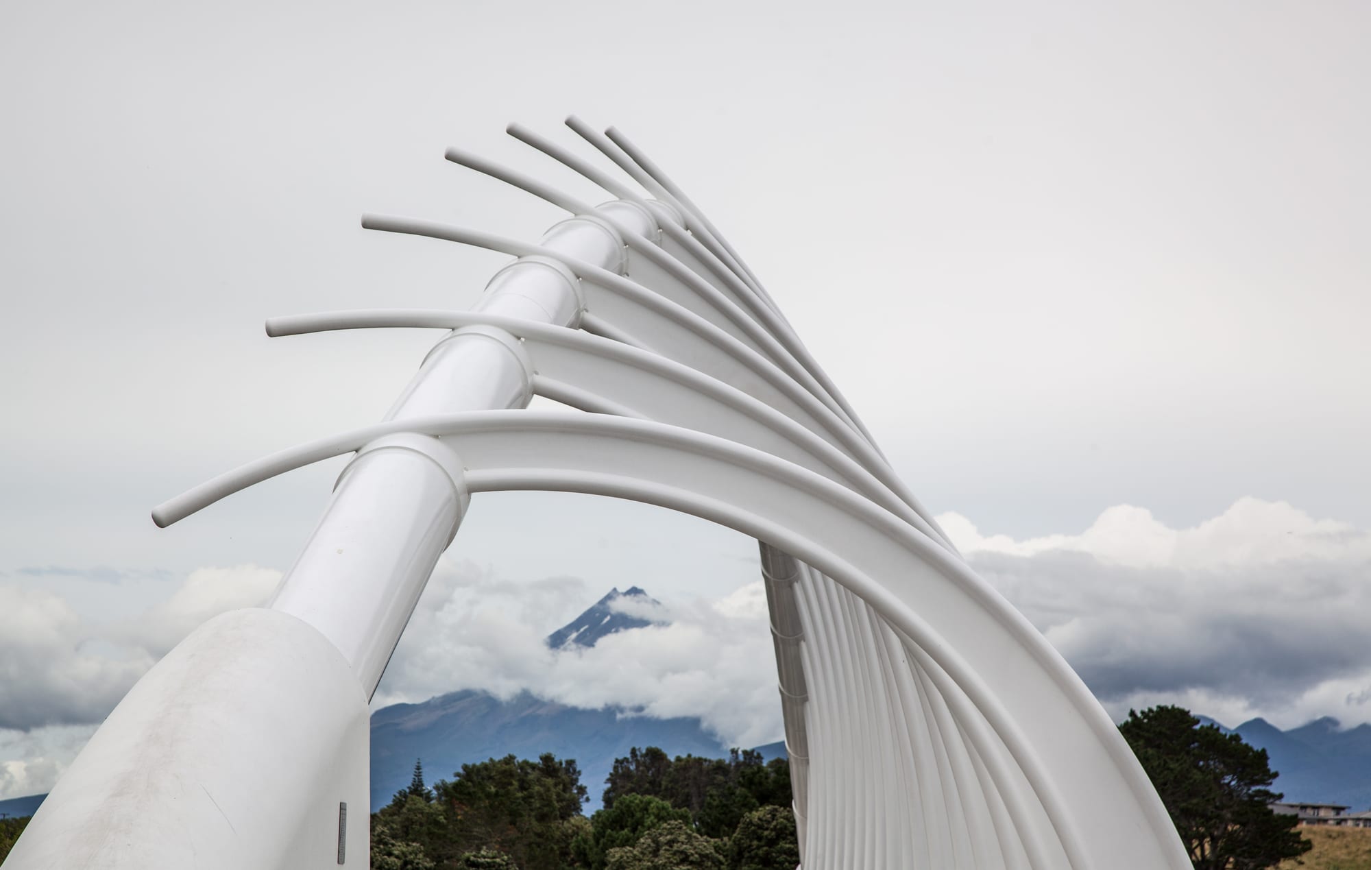
A white steel footbridge of curved ribs framing a distant snow-dusted volcanic cone above trees

Wellington & the Lower North Island, New Zealand

New Plymouth

The Te Rewa Rewa Bridge on New Plymouth's Coastal Walkway, framing Taranaki Maunga. (russellstreet / Wikimedia Commons · CC BY-SA 2.0)

The main city of Taranaki, on the west coast of the North Island between a black-sand shore and the volcanic cone of Taranaki Maunga. Founded by British settlers in 1841 on land long held by Te Āti Awa, it grew through war, dairying and then oil and gas. Today it is known for its coastal walkway, parks, galleries and surf beaches.

Neighbourhoods

  • The city centre
    • First-time visitors
    • Museums and galleries
    • Close to public transport

    A compact grid around Devon Street, the main shopping run, with Puke Ariki and the Len Lye Centre at its seaward end and the bus centre a short walk away. Most hotels, restaurants and bars are here, and the Coastal Walkway and the Wind Wand are just across the road from the museum.

    Open in Maps
  • Fitzroy and Strandon
    • Beaches
    • Surfing
    • Cafés

    Seaside suburbs a few kilometres east of the centre, reached along the walkway. Fitzroy Beach is a patrolled swimming and surfing beach, backed by a small strip of cafés and shops, and the streets behind it are quiet and residential.

    Open in Maps
  • Moturoa and Ngāmotu
    • Sea views
    • Walks
    • Local life

    The western side of the city, where the breakwater, Port Taranaki and the sheltered beach beside it face the Sugar Loaf Islands. The volcanic stump of Paritutu rises behind, with a steep track to the top, and the area mixes industry, boat clubs and older houses.

    Open in Maps
  • Vogeltown and Westown
    • Quiet and residential
    • Views of the mountain

    Inner hill suburbs above the centre, laid out in streets of bungalows and villas with long views to the mountain or the sea. They are handy for Pukekura Park and the hospital, and a walk or short bus ride from the shops.

    Open in Maps
  • Bell Block and Waiwhakaiho
    • Close to the airport
    • Shopping

    The eastern approach to the city, where the airport, big-box retail parks and newer housing estates are, either side of the Waiwhakaiho River. The walkway and Te Rewa Rewa Bridge reach this far, and the surf break at Waiwhakaiho draws boards in a swell.

    Open in Maps

Things to do

The waterfront

  • New Plymouth Coastal Walkwaytrail

    A sealed path running some thirteen kilometres along the shore, past beaches, river mouths and reserves, used by walkers, runners and cyclists.

    Open in Maps
  • Te Rewa Rewa Bridgelandmark

    A white footbridge over the Waiwhakaiho River whose curved ribs, suggesting a wave or a whale skeleton, frame the mountain on a clear day.

    Open in Maps
  • Wind Wandlandmark

    A slender red kinetic sculpture 45 metres tall on the foreshore, designed by the Taranaki-born artist Len Lye and installed in 1999, bending in the sea wind.

    Open in Maps
  • Port Taranakilandmark

    The only deep-water port on New Zealand's west coast, established in 1875, with a long breakwater and a sheltered shore looking out to the Sugar Loaf Islands.

    Open in Maps
  • Fitzroy Beachbeach

    A black-sand beach a short way east of the centre, with a surf club and consistent waves, and among the first in Oceania to gain Blue Flag accreditation in 2007.

    Open in Maps

Museums and galleries

  • Puke Arikimuseum

    The regional museum, library and information centre, strong on Taranaki's Māori history, the wars of the 1860s and the region's natural history.

    Open in Maps
  • Govett-Brewster Art Gallerymuseum

    A contemporary art gallery opened in 1970, which holds the archive of the filmmaker and sculptor Len Lye.

    Open in Maps
  • Len Lye Centremuseum

    A stainless-steel-fronted wing beside the Govett-Brewster, opened in 2015, devoted to Len Lye's kinetic sculpture and films.

    Open in Maps

Parks and gardens

  • Pukekura Parkpark

    A large park of lakes, ferns and glasshouses in the middle of the city, laid out from 1876, with a cricket ground at its north-western end.

    Open in Maps
  • Bowl of Brooklandsattraction

    An outdoor stage set across a lake in Brooklands Park, used for large concerts and festivals.

    Open in Maps
  • Tūparepark

    An English-style garden around an arts-and-crafts house on the Waiwhakaiho River, on the southern edge of the city.

    Open in Maps
  • Pukeitipark

    A rhododendron garden of national significance set in rainforest in the hills south-west of the city, founded in 1951 and run by the regional council.

    Open in Maps

Landmarks and viewpoints

  • Paritutu Rockviewpoint

    The steep remnant of an old volcano at the western end of the city, with a short, sharp climb to a view along the coast.

    Open in Maps
  • Sugar Loaf Islandsattraction

    A group of rocky islets and stacks offshore, protected as a marine area and home to seals and seabirds, seen from the shore or by boat.

    Open in Maps
  • Taranaki Cathedral Church of St Marylandmark

    The oldest stone church in New Zealand, begun in 1845 to a design by Frederick Thatcher, whose graveyard holds settlers and soldiers of the Taranaki wars.

    Open in Maps
  • Stadium Taranakiattraction

    The region's main sports ground, home of Taranaki provincial rugby and known as Yarrow Stadium until 2025, a short way south of the centre.

    Open in Maps

Short trips from the city

  • Taranaki Maungaattraction

    The near-symmetrical volcano that dominates the region, with visitor centres, day walks and a summit climb for the experienced and well equipped.

    Open in Maps
  • Egmont National Parkpark

    The roughly circular park around the mountain, officially renamed Te Papa-Kura-o-Taranaki in 2025 and reached in under an hour from the city, with rainforest tracks, waterfalls and alpine routes.

    Open in Maps
  • Ōakurabeach

    A surf village fifteen kilometres south-west on State Highway 45, with a long black-sand beach that was among the first in Oceania to gain Blue Flag accreditation.

    Open in Maps
  • Waitaraneighborhood

    A town at a river mouth north-east of the city, the place where the disputed land sale that began the Taranaki War in 1860 lay.

    Open in Maps

Seasonal events

  • WOMAD New ZealandMarch

    A world music, arts and dance festival held in Pukekura Park and the Bowl of Brooklands over a weekend in late March.

  • Festival of LightsDecember to February

    Pukekura Park lit at night through the summer, with free music and children's events among the trees and lakes.

  • Taranaki garden festivalSpring

    The region's annual garden festival, when private and public gardens across Taranaki open to visitors and the rhododendrons are at their best.

Eat and drink

Long-standing places and food districts in New Plymouth. Hours, ratings and directions come from your maps app, always current.

New Plymouth classics

  • Taranaki dairy and cheesemarket

    The region's dairy farms supply some of the country's biggest milk processing plants, and local cheese, butter and ice cream appear on menus and in shops across the city.

    Open in Maps
  • Fish from Port Taranakirestaurant

    Snapper, kahawai, gurnard and trevally landed on the west coast turn up in the city's fish shops, takeaways and restaurants.

    Open in Maps

Food districts

  • Devon Street and the West Endneighborhood

    The main street and the lanes off it hold most of the city's cafés, bakeries, bars and restaurants, with a cluster near the museum and the foreshore.

    Open in Maps
  • Fitzroyneighborhood

    A small beachside strip of cafés, a bakery and casual restaurants a few minutes from the surf.

    Open in Maps
  • Ngāmotu and the portneighborhood

    Waterfront eating on the western side, with views over the harbour and the islands.

    Open in Maps

Experience New Plymouth

History

Taranaki was settled by Māori many centuries ago, and the area around the present city, known as Ngāmotu for the islands off its shore, was held by Te Āti Awa, with pā on the headlands and on the Sugar Loaf Islands themselves. In the 1820s and 1830s much of the population left or was displaced during the intertribal musket wars, and many Te Āti Awa moved south to the Wellington region, a migration that later complicated questions of who could sell land.

The Plymouth Company of the New Zealand Company landed its first settlers from Devon and Cornwall in 1841, naming the town after their home port. Their land purchases were disputed by returning Māori owners, and pressure for more land grew. In 1860 the government's insistence on a contested sale at Waitara brought war to the district: fighting spread across Taranaki through the 1860s, settlers sheltered behind stockades in New Plymouth, and large areas of Māori land were confiscated afterwards. At Parihaka, south of the city, the leaders Te Whiti o Rongomai and Tohu Kākahi mounted a campaign of non-violent resistance until troops invaded the village in 1881.

Dairying made the region prosperous once the bush was cleared, and the port built at Moturoa, with its long breakwater, gave the west coast its only deep-water harbour. From 1970 the Kapuni gas field and, later in that decade, the offshore Maui field turned New Plymouth into the centre of New Zealand's oil and gas industry, and engineering and energy firms still line the eastern approaches. Since the 1990s the city has spent heavily on its waterfront, its parks and its galleries, and the decline of the Maui field has pushed local debate towards what comes after gas.

Culture & Customs

For a city of its size New Plymouth has an unusual amount of art. The Govett-Brewster opened in 1970 as a contemporary gallery when few provincial towns had one, and the Len Lye Centre beside it houses the work of the Taranaki-born artist and filmmaker whose kinetic sculptures also stand on the foreshore as the Wind Wand. Public sculpture, murals and the design of the Coastal Walkway's bridges are part of the same civic habit.

Music and gardens shape the calendar. WOMAD brings musicians from around the world to the Bowl of Brooklands each March, large touring acts play the same stage in summer, and Pukekura Park is lit for the Festival of Lights through the holidays. Spring belongs to the garden festival, a regional institution built on the volcanic soil and high rainfall that make rhododendrons and camellias thrive.

Māori history is close to the surface. Te Āti Awa and the other Taranaki iwi maintain marae across the district, the confiscations of the 1860s and the events at Parihaka are taught and commemorated, and the mountain's restoration to the name Taranaki Maunga and its recognition in law as a legal person in 2025 were widely marked. Surfing along the black-sand coast, provincial rugby in amber and black, and dairy-farming family networks make up the rest of the local identity.

Daily Life

About 60,000 people live in New Plymouth and around 90,000 in the wider district, which makes it the major city of the Taranaki region. Most housing is single-storey and detached, spreading east through Waiwhakaiho and Bell Block, west to Moturoa and Spotswood, and up the inner hills of Vogeltown and Westown, with the newest subdivisions on former farmland at the edges.

The economy rests on three legs: dairy processing and farm services, energy and engineering, and the public sector of hospital, schools and council, with tourism and retail growing. Fonterra's plants in the region take milk from thousands of farms, the port ships logs, dairy products and petrochemicals, and the energy sector has been shrinking as gas fields decline — a source of anxiety about skilled jobs. Many workers commute in from the smaller Taranaki towns.

The day is early and outdoors. The Coastal Walkway is busy with runners, cyclists and dog walkers before work, surfers check the beaches on the way in, and weekends go to sport, the parks, the mountain or a barbecue. Rain arrives often and briefly, so plans are made loosely. Housing costs have risen faster than incomes, pressure on the hospital and on rentals is a standing complaint, and coastal erosion and the future of the energy industry are the issues that fill local meetings.

Food

Taranaki is dairy country, and the region's identity is bound up with milk. Its processing plants are among the largest in the country, and local cheese, butter, cream and ice cream are staples rather than specialities; farm-gate and market stalls sell them alongside eggs, honey and vegetables grown on the rich volcanic soils. The mild, wet climate also suits berries and stone fruit in summer.

From the sea come snapper, kahawai, gurnard, trevally and, in season, crayfish and pāua taken from the rocky coast under strict limits. Whitebait, the tiny young of native fish, are netted in the river mouths in spring and eaten in fritters bound with egg — a west coast ritual as much as a dish. Fish and chips eaten on the breakwater or by the sea is the classic local supper.

The city's own cooking is modern New Zealand: café brunches, flat whites, sourdough and eggs on Devon Street, wood-fired pizza and small-plate restaurants near the foreshore, and pubs serving steaks, lamb and burgers with Taranaki beef. Craft breweries have opened in and around the city, and one long-standing Taranaki brewery has been making beer in the region for generations. Māori kai appears at hui and festivals — hāngī cooked in the ground, kina, mussels and pork and puha — and WOMAD each March fills Pukekura Park with food stalls from around the world.

Planning tools

Budget

New Plymouth is one of the better-value New Zealand cities, with motels along the coast road, a hostel or two and moderate restaurant prices. The main attractions — the walkway, Pukekura Park, the galleries and the beaches — cost little or nothing. Rooms tighten and prices rise for WOMAD, the garden festival and big concerts at the Bowl of Brooklands, and a hire car is the usual way to reach the mountain.

Daily Budget Midrange
USD 140–270 (motel or boutique hotel, restaurants, a hire car, a guided walk or gallery visits)
Daily Budget Shoestring
USD 55–90 (hostel or holiday park, supermarket and bakery food, walkway, parks and galleries)

Book well ahead for festival weekends in March and for the garden festival; the Coastal Walkway, Pukekura Park and the Govett-Brewster's public spaces cost nothing.

Best Time to Visit

December to March for the warmest, driest weather, summer events and the best chance of clear mountain days, with WOMAD in March. Spring brings the gardens into flower and the region's garden festival. Winter is mild but wet and windy on the coast, with snow on the mountain and quiet, cheaper accommodation in town.

Suggested Number of Days

Two days cover the city, which is small and mostly walkable along the coast. Three to five allow time for the mountain, the gardens and the surf coast. Cloud and rain can hide the mountain for days, so a longer stay improves the odds of seeing it.

First Visit
2 days
With Surroundings
3–5 days

Transportation

Citylink buses run from the central bus centre to the suburbs, Bell Block, Waitara and Ōakura, with a thinner service in the evenings and at weekends. Most visitors drive, since the mountain, the gardens and the coast need a car, and parking in the centre is straightforward. The Coastal Walkway makes cycling along the shore easy, and bikes can be hired in town. Taxis and ride-hailing operate on a small scale.

Mountain roads narrow and climb quickly, and cloud can cut visibility; allow more time than the distance suggests.

Airport & Station Connections

New Plymouth Airport is about eleven kilometres north-east of the centre, near Bell Block, with flights to Auckland, Wellington and Christchurch and a short taxi or shuttle ride into town. By road the city is roughly four to five hours from both Auckland and Wellington, and long-distance coaches serve it daily. There is no passenger rail service, and the region is a detour from the main north–south highway.

Walkability

The centre is flat, compact and pleasant on foot, and the Coastal Walkway gives a level, uninterrupted route along the shore for kilometres in each direction. Pukekura Park is a few minutes' walk uphill from Devon Street. The hill suburbs are steep, and Bell Block, the airport and the mountain all need a bus or car. Wind and rain off the Tasman Sea are the main discouragement.

Safety

A safe provincial city with low levels of serious crime; theft from parked cars at beaches and trailheads is the common problem. The real hazards are natural. The west coast has strong rips and heavy surf, and swimming is safest between the flags at patrolled beaches. Taranaki Maunga has killed many climbers, with fast weather changes, ice and steep ground.

Swim at patrolled beaches, check the forecast and take full warm and waterproof gear on the mountain, turn back in bad weather, and consider a guide for the summit. Check current official travel advice before travelling.

Climate

Mild, windy and wet, with weather that changes fast as the mountain and the Tasman Sea interact. Rainfall is high and spread through the year, much heavier on the mountain than in the city, and the region gets reasonable sunshine between fronts. Frost and snow are rare at sea level. Summer runs from December to February in the southern hemisphere.

Summer
warm and changeable, with daytime highs usually around 21–24°C and a sea breeze most afternoons
Winter
mild and wet, with daytime highs around 12–14°C, frequent westerly rain and snow on the mountain

Local Customs

Dress and manners are casual, first names are used at once, and tipping is not expected. Taranaki is the rohe of Te Āti Awa and other iwi, and the wars and land confiscations of the 1860s, together with the non-violent resistance at Parihaka, are living history here; the Crown apologised for the invasion of Parihaka in 2017. Local people speak of the mountain as Taranaki Maunga, which was granted legal personhood in 2025, and treat its summit as sacred.

Photo identification is asked for when buying alcohol, and supermarkets sell beer and wine but not spirits. Permission should be sought before photographing people, marae or wāhi tapu, and the very summit of the mountain is best not stood upon out of respect.

Common Payment Methods

The currency is the New Zealand dollar. Cards and contactless payment are taken almost everywhere, sometimes with a small credit-card surcharge, and cash is rarely needed except at markets and farm stalls. ATMs are along Devon Street and in the suburban shopping centres, and tipping is not added to bills.