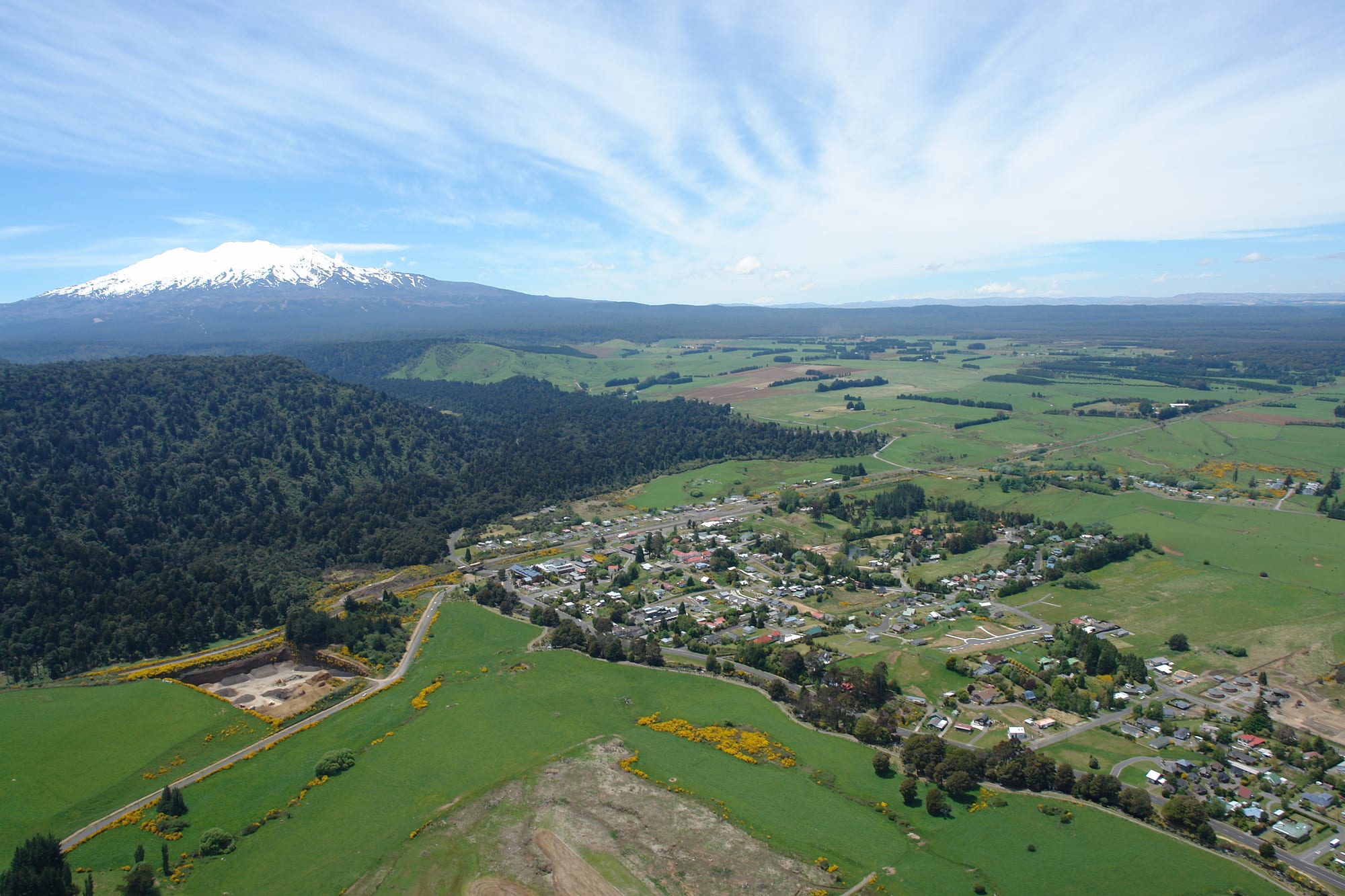
Aerial view of a small town among green paddocks and native forest, with a snow-capped volcano on the horizon

Wellington & the Lower North Island, New Zealand

Ohakune

Ohakune from the air, with the snow-covered cone of Mount Ruapehu beyond the farmland and forest. (Duane Wilkins / Wikimedia Commons · CC BY 3.0)

A small town on the southern side of Mount Ruapehu, in the central North Island, grown from a railway and timber settlement into a market-gardening district and the main base for the Tūroa ski area and the southern side of Tongariro National Park. Fewer than two thousand people live there, and the population swells through the winter ski season.

Neighbourhoods

  • The town centre
    • First-time visitors
    • Shops and cafés
    • Quiet and residential

    The lower part of town along Clyde Street and Goldfinch Street, where the shops, cafés, supermarket, information centre and most of the year-round services are. Streets of weatherboard houses, motels and holiday rentals spread out around it, and the giant carrot sculpture stands at the eastern entrance.

    Open in Maps
  • Ohakune Junction
    • Nightlife
    • Close to public transport
    • Skiers

    The upper settlement around the railway station, a couple of kilometres from the centre and closer to the mountain road. In winter its bars, restaurants and lodges are the noisiest part of the district; out of season it is very quiet. Trains on the main trunk line stop here.

    Open in Maps
  • Ohakune Mountain Road
    • Skiing and snowboarding
    • Walks
    • Waterfalls

    The seventeen-kilometre road climbing from the town through rimu forest, beech and tussock to the Tūroa ski area high on Ruapehu, built largely by volunteer labour and opened in 1963. Short walking tracks, waterfalls and lookouts lead off it, and it is the route skiers and walkers take up the mountain in season.

    Open in Maps
  • Rangataua and the rural edges
    • Quiet and residential
    • Local life

    Small settlements and market gardens on the flats east and west of town, where much of the district's vegetable growing happens. Rangataua is a village five kilometres south-east with a marae and scenic reserves behind it, and Raetihi lies about eleven kilometres west.

    Open in Maps

Things to do

The mountain and the snow

  • Mount Ruapehuattraction

    The highest mountain in the North Island and New Zealand's largest active volcano, with Crater Lake set between its peaks, the North Island's only glaciers, and three ski fields on its slopes.

    Open in Maps
  • Tūroaattraction

    The ski area on Ruapehu's south-western flank above Ohakune, opened in 1978 and reached by the Mountain Road, with about 690 metres of vertical drop from the top chairlift.

    Open in Maps
  • Tongariro National Parkpark

    New Zealand's oldest national park, listed by UNESCO for both its landscapes and its cultural importance to Māori, with Ohakune at its southern edge.

    Open in Maps

Walks, waterfalls and rides

  • Ohakune Old Coach Roadtrail

    A restored early 20th-century coach road between Ohakune and Horopito, walked or cycled past the historic Hapuawhenua Viaduct, and the first section of the national cycle trail network to be completed, in 2010.

    Open in Maps
  • Mangawhero Fallsattraction

    A twenty-five-metre waterfall on the upper Mangawhero River beside the Ohakune Mountain Road, reached in a few minutes from the road, in a valley used as a filming location for the Lord of the Rings films.

    Open in Maps
  • Mountains to Sea Cycle Trailtrail

    A 231-kilometre cycle route, Ngā Ara Tūhono, that starts high on Ruapehu and runs down through Whanganui country to the sea, taking in the Old Coach Road and a boat or kayak stretch on the Whanganui River.

    Open in Maps

In the town

  • Ohakune railway stationtransit hub

    The station at the Junction on the North Island Main Trunk line, the second-highest operating railway station in the country, still served by the Auckland–Wellington train and a reminder of why the town exists.

    Open in Maps
  • Ohakune Carrotlandmark

    A 7.5-metre replica carrot on the eastern edge of town, put up to mark the district's market gardening and now the town's best-known photograph.

    Open in Maps

Short trips from the town

  • Whakapapa skifieldattraction

    The ski area on Ruapehu's northern side, reached by Bruce Road above Whakapapa Village, about an hour and a half away by road around the mountain.

    Open in Maps
  • Tongariro Alpine Crossingtrail

    A demanding day walk across volcanic craters and past coloured lakes on the northern side of the park, reached by shuttle from the villages.

    Open in Maps
  • Tangiwaiattraction

    The rail bridge seventeen kilometres east of town where a lahar from Ruapehu's Crater Lake destroyed a pier minutes before an express train reached it on Christmas Eve 1953, killing 151 people in the country's worst rail accident.

    Open in Maps

Seasonal events

  • Ohakune Carrot Carnivalannual, held since 1996

    A community festival celebrating the district's vegetable growing, with competitions between growers, carrot-themed food and family attractions.

  • Ohakune Mardi Grasduring the ski season

    A one-night music event held in the town since 1996, when it was set up to bring visitors back after the Ruapehu eruptions; about 8,000 people came in 2024.

  • The ski seasonwinter, roughly late June to October

    The months when the lifts run on Ruapehu, lodges and bars fill, and the town works to mountain hours; the length of the season varies with the snow.

Eat and drink

Long-standing places and food districts in Ohakune. Hours, ratings and directions come from your maps app, always current.

Ohakune classics

  • Local vegetables and mountain pub foodneighborhood

    Kitchens in town lean on the district's own produce — carrots, parsnips, swedes and potatoes grown on the volcanic soils — alongside hearty winter cooking, venison and craft beer.

    Open in Maps

Food districts

  • Clyde Street and the town centreneighborhood

    The main street holds the cafés, bakery, takeaways, supermarket and a few restaurants; some close or shorten their week outside the ski season.

    Open in Maps
  • Ohakune Junctionneighborhood

    The upper village by the station, where the après-ski bars, pizza places and lodge restaurants cluster in winter.

    Open in Maps
  • Raetihineighborhood

    A small town eleven kilometres west with a handful of cafés and a bakery, useful when Ohakune is busy.

    Open in Maps

Experience Ohakune

History

The land around Ohakune belongs to the story of Ngāti Rangi and neighbouring iwi, whose relationship with Ruapehu goes back many generations and who lived along the rivers and forest tracks of the mountain's southern side. The modern town began in the early 1890s where the Mangawhero and Mangateitei rivers meet, on the road from Raetihi to Taumarunui, and the railway made it: the North Island Main Trunk line reached Ohakune in March 1908 and was completed in November that year, and a second settlement grew around the station at what became Ohakune Junction.

Timber came first. The rimu and beech forests of the Waimarino district were milled and carried out by rail, and from 1909 to the late 1920s sawmilling paid the town's wages. As the bush was cleared, the volcanic soils turned out to suit vegetables, and market gardening took over, much of it worked by Chinese gardeners who leased the cleared land: carrots above all, with swedes, parsnips and potatoes, sent to markets around the country. By 1941 the district was reported to grow almost half of the North Island's vegetables, and the town's giant carrot celebrates that trade.

The third phase was snow. Skiers had used Ruapehu since the 1910s, mostly on the northern side, but the opening of a ski area at Tūroa on the mountain's south-western slopes in 1978 turned Ohakune into a winter resort, with lodges, bars and holiday houses. The eruptions of 1995 and 1996 closed all three ski fields on the mountain and cost the region dearly; the fields' operator was liquidated in 2023 and Tūroa passed to a new owner. Walking and mountain biking, and the reopened Old Coach Road, have built up a second, quieter season.

Culture & Customs

Ohakune has two personalities in a single year. Through the winter it is a ski town: hire shops open early, buses run up the Mountain Road, and the Junction fills with people in ski gear who eat and drink late. Seasonal workers arrive from around New Zealand and overseas, and events such as the Mardi Gras draw large crowds for a night. Once the lifts stop, the town returns to a quiet farming and forestry community of a few streets, where most people know each other and the school and sports clubs are the centre of social life.

Ruapehu itself shapes local identity and custom. For Ngāti Rangi the mountain is an ancestor rather than scenery, and visitors are asked to treat the summit and crater area as sacred. The iwi has been closely involved in the management of Tongariro National Park, and its settlement with the Crown recognised that relationship. Māori place names and marae, at Rangataua and nearby, remain part of the district's fabric.

The carrot is the town's own joke and emblem, celebrated with a carnival, a sculpture and a great deal of merchandise. Rugby, hunting, fishing and gardening fill much of the rest of the year, and the annual rhythm of snow, then planting, then harvest, is still the way people describe their calendar.

Daily Life

Ohakune has fewer than two thousand residents — roughly 1,350 in the town itself — and the wider Waimarino district, including Raetihi and Rangataua, adds a few thousand more. Winter visitors can multiply that figure many times over on a busy weekend, which is why the town has more accommodation, restaurants and bars than a settlement of its size would otherwise support.

Work is seasonal in two directions. Market gardening and forestry employ people through the warmer months, with planting, harvesting and packing on the flats around town and logging trucks on the highways; the ski season brings work in lift operations, hospitality, retail and hire shops. Many households combine the two, and some depend on the mountain opening at all, so a poor snow year is felt across the district.

Daily life is practical: school buses on long rural routes, the supermarket and the medical centre in town, and longer trips to Taumarunui, Whanganui or Palmerston North for hospital care and larger shopping. Holiday houses owned by city families sit empty much of the year, which lifts property prices and squeezes rentals for local workers — a familiar problem in New Zealand resort towns. Cold, damp housing, the cost of heating and the uncertainty around the ski fields' future are recurring concerns.

Food

Vegetables are the local speciality, and they are grown rather than cooked into any famous dish. Carrots are the emblem, but the paddocks also produce swedes, parsnips, potatoes, brussels sprouts and other cold-weather crops, sold at farm gates and roadside stalls and trucked to supermarkets nationwide. Summer visitors often take home a sack of whatever has just been lifted.

Eating out follows the snow. In winter the town supports pizza places, pubs, cafés, burger joints and a few more ambitious restaurants, mostly around Clyde Street and the Junction, serving the sort of food skiers want: big plates, soups and stews, roast dinners, venison and beef, and beer from New Zealand craft breweries. Mulled wine and hot chocolate appear on blackboards, and the bakery's pies and filled rolls are a standard mountain lunch. In the off season the choice narrows sharply and some kitchens close for weeks.

Wild food is part of the local table. Red deer and pigs are hunted in the surrounding forests, and trout are taken from the Mangawhero and other rivers in the season, and both appear at home rather than in restaurants. Elsewhere the fare is standard New Zealand: flat whites in the morning, fish and chips wrapped in paper, lamb on a Sunday, and pavlova or hokey pokey ice cream to finish.

Planning tools

Budget

Costs swing with the season. In winter, beds in lodges, motels and chalets are in demand and prices rise, and lift passes, hire gear and lessons are the biggest expense of a visit. From late spring to autumn the same accommodation is much cheaper and often half empty, and the walking and cycling are free. There is a holiday park and backpacker accommodation in town.

Daily Budget Midrange
USD 140–270 (motel or lodge, restaurants, a hire car, a lift pass or guided walk)
Daily Budget Shoestring
USD 50–90 (hostel or holiday park, supermarket food, national park walks and the Old Coach Road)

Winter weekends and school holidays book out months ahead; a self-catering room saves money in a town with few cheap restaurants.

Best Time to Visit

Two quite different seasons. From roughly late June to October the ski fields run and the town is busy, lively and expensive. From December to March the weather is warmest and most settled for the national park walks, waterfalls and cycle trails, and prices are lower. Late autumn and early spring are quiet, with many businesses closed or on short hours.

Suggested Number of Days

Two days are enough for the town and a day on the mountain. Three to five suit a ski trip or a walking and cycling stay taking in the wider national park. Weather often decides the length, since mountain days are lost to wind and rain.

First Visit
2 days
With Surroundings
3–5 days

Transportation

The town is small enough to walk, though the centre and the Junction are a couple of kilometres apart and a shuttle bus links them and the ski area in winter. Outside the season a car is close to essential, as the surrounding sights are spread along the Mountain Road and the highways. The Auckland–Wellington train stops at the station, and long-distance buses call on the main road.

Carry snow chains and check road and ski-field status in winter, as the Mountain Road can be closed or chains-only.

Airport & Station Connections

Ohakune is on State Highway 49 in the central North Island, roughly four hours' drive from both Auckland and Wellington and about two hours from Taupō or Whanganui. The Northern Explorer train between Auckland and Wellington stops at the Junction a few times a week in each direction, which makes it one of the few New Zealand ski towns reachable by rail. The nearest airports are at Whanganui, Palmerston North and Taupō.

Walkability

The centre is flat and easily covered on foot, with shops, cafés and accommodation within a few blocks. The walk between the centre and the Junction is a gentle uphill of about two kilometres, done by many visitors but dark and cold on winter nights. Footpaths can be icy, and everything beyond the two villages needs wheels.

Safety

The town is safe and crime is low, with theft from cars at trailheads and ski car parks the usual complaint. The risks are alpine and volcanic: Ruapehu is an active volcano with a history of eruptions and lahars, mountain weather changes quickly, and skiing or walking above the bush line brings cold, whiteouts and avalanche risk.

Take warm and waterproof layers even in summer, follow the volcanic alert information and marked lahar routes on the mountain, leave word of the intended route before a long walk, and never cross a flooded river. Check current official travel advice before travelling.

Climate

A cool upland climate at around 600 metres, wetter and colder than the lowlands, with the mountain making its own weather. Rain and cloud are common in all seasons, clear frosty spells come in winter, and snow falls on the town a few times most winters and lies much longer above it. Summer runs from December to February in the southern hemisphere.

Summer
mild, with daytime highs usually around 19–22°C, cool nights and sudden showers
Winter
cold, with daytime highs around 7–10°C, hard frosts, and snow on the mountain from about June

Local Customs

Small-town New Zealand: informal dress, first names, and a nod or wave to people passed on the road. Tipping is not expected. The mountain is sacred to Ngāti Rangi and the other iwi of the district, and its summits are treated with respect — the Department of Conservation asks visitors not to climb to the summits or swim in the sacred lakes. Skis and boots come off at the door of lodges.

Photo identification is asked for when buying alcohol; bars can be crowded and boisterous in the ski season, and liquor may not be taken onto the ski fields. Permission should be sought before photographing people or marae.

Common Payment Methods

The currency is the New Zealand dollar, and cards and contactless payment work in shops, cafés and on the mountain, sometimes with a card surcharge. ATMs are in the town centre but can run short on busy winter weekends, so a little cash is useful for roadside vegetable stalls and community events.