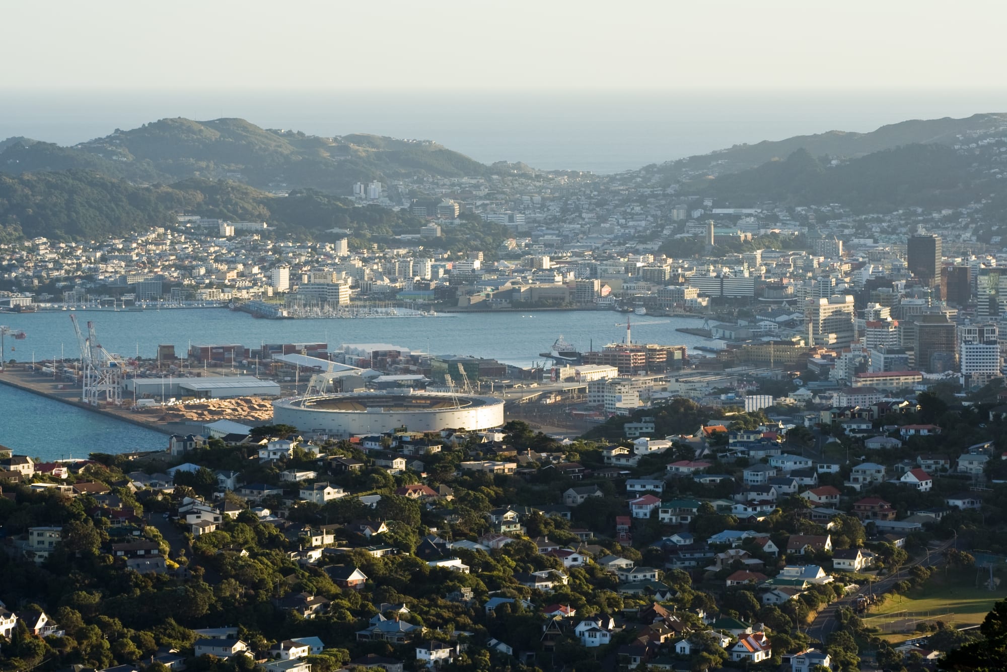
A city around a blue harbour seen from a hilltop, with port cranes, a round stadium, office towers and houses on steep green hills

Wellington & the Lower North Island, New Zealand

Wellington

Wellington's harbour, port, stadium and city centre seen from the hills to the north. (Aidan / Wikimedia Commons · CC BY 2.0)

New Zealand's capital, built on a narrow strip of flat land and steep hills around a deep harbour at the southern end of the North Island. Chosen as the seat of government in 1865, it holds Parliament, the national museum and the country's film industry, and packs cafés, theatres and craft breweries into a compact, windy centre.

Neighbourhoods

  • Lambton Quay and the waterfront
    • First-time visitors
    • Close to public transport
    • Architecture

    The commercial and government core on reclaimed land, where Lambton Quay's shops follow the line of the original shoreline. Parliament, the railway station, the ferry terminals for harbour boats, the cable car and the promenade past Te Papa are all within a few minutes' walk.

    Open in Maps
  • Te Aro, Cuba Street and Courtenay Place
    • Nightlife
    • Best for food
    • Arts and culture

    The southern half of the central city and its liveliest part: Cuba Street's second-hand shops, cafés and bucket fountain, the bars and theatres of Courtenay Place, and streets of small restaurants. Flats above the shops make it a residential quarter as well.

    Open in Maps
  • Oriental Bay and Mount Victoria
    • Beaches
    • Views
    • Quiet and residential

    A curve of imported sand and a seafront promenade just east of the centre, backed by apartment blocks and the wooded slopes of Mount Victoria. The hill above holds villas on winding streets and the lookout with the classic view over the harbour.

    Open in Maps
  • Thorndon and Kelburn
    • Historic district
    • Museums
    • Quiet and residential

    The city's oldest European suburb, on the slopes behind Parliament, with wooden villas, Old St Paul's and the Katherine Mansfield house. Kelburn sits above it, reached by the cable car, and holds the Botanic Garden and the main university campus.

    Open in Maps
  • Newtown and Mount Cook
    • Best for food
    • Local life
    • Budget stays

    A mixed, densely built area a couple of kilometres south of the centre, known for its cheap restaurants, second-hand shops and long-standing migrant communities, with the city hospital and the zoo at its edges.

    Open in Maps
  • Miramar and the eastern bays
    • Film industry
    • Beaches
    • Quiet and residential

    A flat peninsula by the airport that is the centre of the city's film production, with workshops and studios among suburban streets. Beaches at Lyall Bay and Scorching Bay, and the coast road around the harbour heads, are nearby.

    Open in Maps

Things to do

Famous landmarks

  • Beehivelandmark

    The conical Executive Wing of Parliament, from an original design by Basil Spence, built between 1969 and 1981 and housing ministers' offices and the Cabinet room.

    Open in Maps
  • Parliament Houselandmark

    The Edwardian neoclassical debating chamber building next to the Beehive, open to visitors on guided tours that explain how the country is governed.

    Open in Maps
  • Old Government Buildingslandmark

    An 1876 block built of kauri timber to look like stone, the second-largest wooden building in the world until 1998, now the university law school.

    Open in Maps
  • Wellington Cable Carlandmark

    A funicular railway opened in 1902 that climbs from Lambton Quay through tunnels to Kelburn, with a lookout and a small museum at the top station.

    Open in Maps
  • Old St Paul'slandmark

    A colonial Gothic Revival church consecrated in 1866, close to Parliament, built in native timbers, with a dim interior of dark beams and stained glass.

    Open in Maps
  • Wellington Regional Stadiumattraction

    The round stadium beside the railway station, opened in 2000, used for rugby, cricket, football and large concerts.

    Open in Maps

Museums and galleries

  • Te Papa Tongarewamuseum

    The national museum on the waterfront, opened in 1998, covering Māori and Pacific treasures, natural history, art and the country's wars, with free entry for New Zealanders and an admission charge for international visitors.

    Open in Maps
  • Wellington Museummuseum

    The city's own museum in a Victorian bond store on Queens Wharf, covering the harbour, the 1968 Wahine disaster and Wellington's social history.

    Open in Maps
  • Wētā Workshopattraction

    The effects and props company behind the Lord of the Rings and many other films, based in Miramar, where guided tours show how creatures and armour are made.

    Open in Maps
  • Carter Observatorymuseum

    The observatory at the top of the Botanic Garden near the cable car terminus, now the Space Place museum and planetarium, with telescope viewing on clear evenings.

    Open in Maps

Parks, gardens and wildlife

  • Wellington Botanic Gardenpark

    Twenty-five hectares of native bush, exotic trees, glasshouses and the Lady Norwood Rose Garden on the hillside between Kelburn and Thorndon.

    Open in Maps
  • Zealandiapark

    A fenced valley sanctuary of more than 200 hectares in the hills at Karori, cleared of introduced predators, where kākā, tūī, tīeke and tuatara live wild.

    Open in Maps
  • Wellington Zooattraction

    New Zealand's oldest zoo, opened in 1906 in Newtown, with a focus on native species and conservation work alongside its exotic animals.

    Open in Maps
  • Mount Victoriaviewpoint

    A bush-covered hill immediately above the centre with a road and tracks to a lookout over the harbour, the city and Cook Strait.

    Open in Maps
  • Mount Kaukauviewpoint

    The most visible high point above the city at 445 metres, marked by Wellington's main television mast, reached on a steep track from the northern suburbs for a view over the whole harbour.

    Open in Maps

The waterfront and the coast

  • Oriental Baybeach

    The city's swimming beach, a short walk from the centre along the waterfront, rebuilt in 2004 with sand shipped from Golden Bay, with a promenade and the Freyberg Pool at its city end.

    Open in Maps
  • Matiu / Somes Islandattraction

    An island in the harbour used as a quarantine station and wartime internment camp, now a predator-free reserve reached by harbour ferry.

    Open in Maps
  • Pariwhero / Red Rockstrail

    A coastal track from Ōwhiro Bay past outcrops of red volcanic rock to Sinclair Head, where New Zealand fur seals may be seen between May and August.

    Open in Maps

Short trips from the city

  • Petoneneighborhood

    Across the harbour in Lower Hutt, the oldest European settlement in the region, founded in January 1840, with a long shopping street of cafés and shops, a settlers' museum and a beach facing the city.

    Open in Maps
  • Eastbourneneighborhood

    A string of small bays on the harbour's eastern shore, reached by the ferry to Days Bay, with sheltered swimming beaches and walking tracks in the hills behind.

    Open in Maps
  • Martinboroughneighborhood

    A small Wairarapa town over the Remutaka hill, surrounded by pinot noir vineyards close enough to the town centre to reach by bicycle.

    Open in Maps
  • Kapiti Islandpark

    A nature reserve island up the west coast, one of the country's oldest protected sanctuaries, visited by permit and boat for its birdlife.

    Open in Maps

Seasonal events

  • CubaDupaMarch

    A street festival that closes Cuba Street for two days of music, performance and food stalls.

  • New Zealand Festival of the Artslate summer, in alternate years

    A biennial multi-arts festival running about three weeks, with theatre, dance, music and writing programmes in venues across the city and the wider region.

  • Wellington on a PlateAugust

    A winter food festival of special menus and events, best known for a competition in which restaurants and bars create one-off burgers.

  • BeervanaAugust

    A craft beer festival held at the stadium, reflecting a city with an unusual concentration of breweries.

  • World of WearableArtlate September into October

    A competition and stage show of sculptural, wearable art, staged in Wellington each year after beginning in Nelson.

Eat and drink

Long-standing places and food districts in Wellington. Hours, ratings and directions come from your maps app, always current.

Food districts

  • Cuba Streetneighborhood

    The centre of the city's eating and coffee culture, lined with cafés, bars, dumpling and curry houses, bakeries and late-night places, and its side lanes hold small kitchens and roasteries.

    Open in Maps
  • Courtenay Placeneighborhood

    The main strip of restaurants, bars and theatres at the southern end of the centre, busy after work and after shows.

    Open in Maps
  • Newtown's cheap eatsneighborhood

    Riddiford Street and its surroundings offer some of the city's best value, with South Asian, Middle Eastern, Southeast Asian and African kitchens, grocers and bakeries side by side.

    Open in Maps

Cafés and bars

  • Wellington's coffee roasteriescafe

    The city built a national reputation on espresso from the 1990s, and independent roasters and cafés remain dense in Te Aro, Cuba Street and Thorndon.

    Open in Maps
  • Wellington's craft breweriescafe

    Breweries and taprooms are scattered through Te Aro, Aro Valley and the Hutt Valley, and the city's pubs carry long lists of local beer.

    Open in Maps

Experience Wellington

History

Māori settlement of Te Whanganui-a-Tara, the great harbour of Tara, goes back many centuries, and by the early 19th century the district was held by Te Āti Awa, Taranaki and Ngāti Toa groups who had migrated south. In January 1840 the first New Zealand Company settlers landed at Petone, on the harbour's northern shore, but flooding of the Hutt River pushed them across to the beach at Thorndon and Lambton Quay, where the town was laid out on land whose purchase Māori disputed from the start.

The earthquake of 1855 raised land around the harbour, giving the young town the flat ground that the central city still occupies; later reclamations extended it further into the harbour. In 1865 the seat of government moved from Auckland to Wellington because of its central position between the islands, and government, shipping and the port became the town's business.

The 20th century brought the ferry trade across Cook Strait, suburban railways into the hills and the Hutt Valley, and the growth of the public service. The sinking of the ferry Wahine at the harbour entrance in a 1968 storm, with more than fifty lives lost, remains the city's defining disaster. Economic restructuring in the 1980s cut thousands of government jobs, and the city reinvented itself around culture, cafés and film, with Te Papa opening in 1998 and the Lord of the Rings productions based here from the late 1990s. Since the 2016 Kaikōura earthquake damaged central buildings, strengthening and demolishing older offices has reshaped the skyline again.

Culture & Customs

Wellington is the country's political and creative capital, and both identities show. Parliament, ministries, embassies and the national institutions give the city a well-informed, argumentative public life; the arts give it density. Te Papa, the New Zealand Symphony Orchestra, the Royal New Zealand Ballet, the national drama school and small theatres such as Circa and BATS all sit within a few kilometres, and the biennial arts festival and CubaDupa take over the streets.

Film is the most visible industry. The Wētā companies and their collaborators in Miramar have worked on much of the past quarter-century's fantasy and effects cinema, and the nickname Wellywood is used with a mixture of pride and embarrassment. Coffee and beer are close behind: the city helped establish New Zealand's espresso culture and has one of the highest concentrations of breweries in the country.

Literature and music have deep roots — Katherine Mansfield was born in Thorndon in 1888, and the city has produced generations of bands — and sport runs through it, with the Hurricanes in rugby, the Phoenix in football, and cricket and rugby tests at the stadium. Wellingtonians joke constantly about the wind and are fond of the way it sorts out visitors. Māori language and protocol are more present here than in most New Zealand cities, and Te Āti Awa and Taranaki Whānui are active partners in how the city is run.

Daily Life

About 210,000 people live in Wellington city, with roughly 435,000 in the built-up area including Lower Hutt, Upper Hutt and Porirua, and around 550,000 in the wider region. It is a young, highly educated population: the public service, two universities, technology and consulting firms, film and post-production, and head offices of banks and insurers provide most of the work.

Housing is expensive and often old. Wooden villas and bungalows climb the hillsides on sections reached by steps, and central apartments have filled converted offices, many of which have since needed earthquake strengthening. Commuting is by train from the Hutt Valley and the Kāpiti Coast, by bus from the hill suburbs, and on foot from the inner city, where a large share of residents walk to work.

The daily rhythm is office-hour and café-driven: crowded coffee queues, lunch eaten on the waterfront when the wind allows, after-work drinks, and a busy weekend of markets, bush walks and sport. Current concerns are mostly practical and much discussed: leaking water pipes and wastewater failures, the cost of strengthening old buildings, housing supply and rents, the future of the port and the ferries, and how well the region would cope with a major earthquake.

Food

Wellington's reputation rests on coffee and beer. Roasters established in the 1990s helped make espresso, and the flat white in particular, part of everyday New Zealand life, and independent cafés remain unusually dense in Te Aro, Thorndon and Newtown. Craft brewing followed, with breweries in the inner suburbs and the Hutt Valley and pubs that pour almost entirely local beer; Beervana in August is its annual showcase.

Eating out is the city's habit rather than its luxury. Cuba Street and its lanes hold dumpling houses, ramen and pho bars, Malaysian and Indian kitchens, tapas bars and bakeries; Courtenay Place covers the busier end; and Newtown's Riddiford Street is where the cheapest and most varied cooking is found, a legacy of migration from South and Southeast Asia, the Middle East and the Horn of Africa. Modern New Zealand restaurants build menus around lamb, venison, Cook Strait fish, Marlborough king salmon, crayfish and green-lipped mussels.

Regional produce arrives from close by: Wairarapa pinot noir and olive oil, regional cheeses, Horowhenua vegetables at the weekend markets, and Wellington-made chocolate and peanut butter. Māori food traditions appear in hāngī at community events and in kaimoana — pāua, kina and smoked eel — gathered along the coasts on either side of the harbour. Wellington on a Plate, in the depths of winter, is when the city eats most self-consciously.

Planning tools

Budget

Wellington costs less than Auckland for accommodation but is not cheap: hotels are priced for government and conference travel, so weekdays can be dearer than weekends, and rooms are scarce during big events and rugby tests. Food and drink are the main day-to-day cost, and the city rewards eating in its cheaper districts. Several of the best things — the Botanic Garden, the waterfront promenade and the hill tracks — cost nothing.

Daily Budget Midrange
USD 150–270 (central hotel or apartment, restaurant meals and craft beer, a paid attraction, occasional taxis)
Daily Budget Shoestring
USD 70–120 (hostel bed, self-catering and Newtown or Cuba Street cheap eats, buses, free museums)

Compare weekday and weekend hotel rates, which can be the reverse of most cities; a Snapper card or contactless card makes buses, trains and the harbour ferry straightforward.

Best Time to Visit

Late spring to early autumn, November to April, gives the warmest and calmest weather and the busiest programme of festivals, with the waterfront and Oriental Bay at their best. February and March are usually the most settled months. Winter is cool, wet and windy, but the museums, theatres, cafés and breweries are indoor pleasures, and August brings the food and beer festivals.

Suggested Number of Days

Two or three days suit the central city, which is small enough to cover on foot. Four or five allow the harbour's far shore, the south coast and the Wairarapa or Kāpiti Coast. Wind and rain can close ferries and hill tracks, so a spare day is useful.

First Visit
2–3 days
With Surroundings
4–5 days

Transportation

The compact centre is walkable, and public transport is good by New Zealand standards. Buses run through the city and out to the suburbs; four electrified suburban lines leave the main station for the Johnsonville hill suburbs, the Hutt Valley, Porirua and the Kāpiti Coast, with a diesel service over the hill to the Wairarapa; a harbour ferry crosses to Days Bay and Matiu / Somes Island; and the cable car climbs to Kelburn. Fares are paid with a Snapper card or a contactless bank card. A car is useful only for trips out of the city, and central parking is limited and expensive.

Steep streets, one-way systems and strong winds make cycling harder than the flat waterfront suggests, though the harbour path and the shared lanes are improving.

Airport & Station Connections

Wellington Airport sits at Rongotai, on the low isthmus south-east of the centre, twenty to thirty minutes by bus or taxi, with domestic flights across New Zealand and some services to eastern Australia; its short runway between two bays makes for turbulent approaches. Ferries cross Cook Strait to Picton in the South Island from terminals near the centre, taking about three hours. Long-distance trains run north to Palmerston North and Auckland, and coaches serve the whole lower North Island.

Walkability

One of the easiest New Zealand cities to walk. The centre is flat, built on reclaimed land, and Parliament, the museums, the shops, Courtenay Place and Oriental Bay are all within about twenty-five minutes of each other on a continuous waterfront promenade. The catch is the hills: residential suburbs climb steeply from the centre and are reached by long stairways, zigzag paths and the cable car, and the wind can make exposed corners hard going.

Safety

Wellington is a safe city with low levels of violent crime. The usual caution applies late at night around the bars of Courtenay Place, where alcohol-related trouble is most common, and to bag and car theft in the centre. The city's particular risks are natural: it sits on active faults, and earthquakes are a real possibility, with tsunami evacuation zones marked along the coast. Strong winds bring down branches and make the south coast and harbour dangerous in storms.

Learn the earthquake drill of drop, cover and hold, note the tsunami zone signs near the sea and move inland or uphill after a long or strong quake, and check ferry and flight status in gales. Check current official travel advice before travelling.

Climate

Temperate, maritime and famously windy, sitting where Cook Strait funnels air between the islands, with frequent gales from the north and cold southerlies behind them. Summer is December to February and winter June to August. Temperatures are moderate all year, snow is almost unknown at sea level, and conditions can change within an hour.

Summer
mild to warm — days usually around 20 °C, with long evenings, sea breezes and occasional hot northerly spells
Winter
cool and wet — days around 11–12 °C, rarely freezing, with rain and strong winds

Local Customs

Manners are informal and egalitarian: first names, queueing, and no expectation of tipping, though rounding up for good service is not resented. Māori greetings and words are part of everyday speech in the capital, and pōwhiri and karakia open many public events; on a marae visitors follow their hosts. Shoes are often removed in homes. Dress is practical rather than formal, and layers matter more than style in the wind.

Alcohol cannot be bought under 18 and identification is often requested; smoking and vaping are banned in bars, restaurants and many outdoor public spaces; ask before photographing people or inside marae and some museum galleries.

Common Payment Methods

The currency is the New Zealand dollar. Cards and contactless payment are accepted almost everywhere, including on public transport, and the local EFTPOS system is universal; some small businesses add a card surcharge. ATMs are common in the centre. Prices include the 15 per cent goods and services tax.