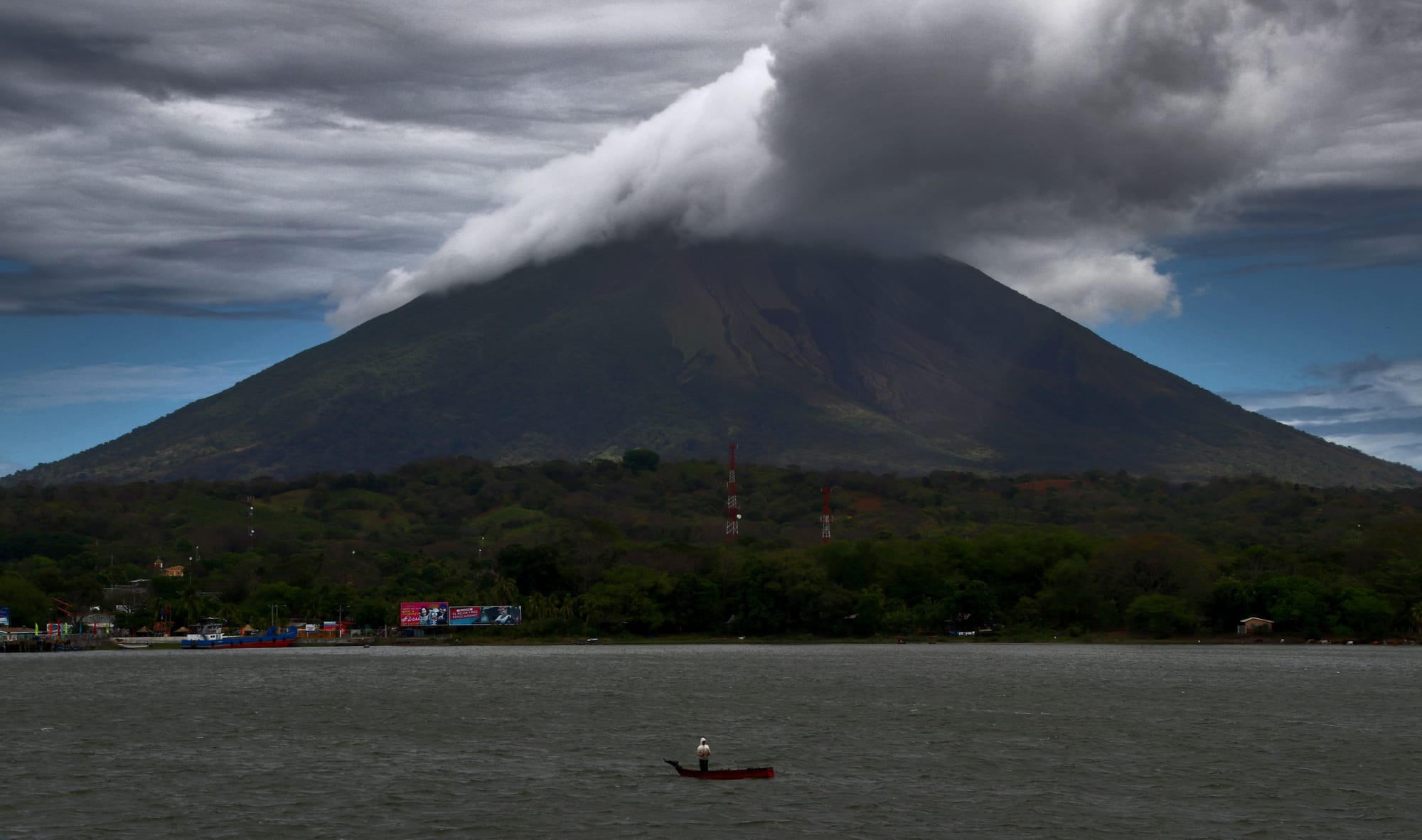
The dark cone of Concepción volcano under heavy cloud above the green shore of Moyogalpa, with a small boat on the lake

Granada, León & the Pacific, Nicaragua

Ometepe

Concepción volcano above the harbour of Moyogalpa, seen on the ferry crossing to Ometepe. (Guillaume Baviere from Uppsala, Sweden / Wikimedia Commons · CC BY-SA 2.0)

The largest island in Lake Nicaragua, formed by two volcanoes — active Concepción and forested Maderas — joined by a low isthmus. Farmed and carved with petroglyphs for well over two thousand years, it is now a rural island of plantain fields, two small port towns and scattered villages, reached by ferry from San Jorge.

Neighbourhoods

  • Moyogalpa
    • First-time visitors
    • Close to public transport

    The harbour town on the north-western shore, where most ferries from San Jorge arrive, with guesthouses, restaurants, small shops and motorbike rental near the dock. Buses to the rest of the island start here.

    Open in Maps
  • Altagracia
    • Local life
    • Quiet and residential

    The other main town, on the north-eastern side of Concepción, founded after Franciscans arrived in 1613. It has the island museum, its own port for boats from Granada and San Carlos, and the fiesta of its patron saint.

    Open in Maps
  • Santo Domingo and the isthmus
    • Beaches
    • Nature

    The low neck of land joining the two volcanoes, where the road runs along Santo Domingo beach, the only sand beach easily reached on the eastern side. Guesthouses are spread out along the shore.

    Open in Maps
  • The Maderas villages
    • Hiking
    • Quiet and rural

    Balgüe, Santa Cruz, Mérida and San Ramón ring the slopes of Maderas, among coffee and tobacco farms. They are the starting points for the Maderas climb and the petroglyph sites; the west side around Mérida is sheltered from the wind and suits kayaking.

    Open in Maps

Things to do

The volcanoes

  • Concepcióntrail

    The active, near-symmetrical 1,610-metre cone on the north-western half of the island, which has erupted at least 25 times since 1883, most recently in May 2024; trails climb through forest to its ash-covered top.

    Open in Maps
  • Maderastrail

    The 1,394-metre volcano on the south-eastern half, inactive in historical times, with a crater lake and cloud forest; the steep, often muddy round trip to the crater takes six to nine hours.

    Open in Maps

Petroglyphs and museums

  • Petroglyphs at Finca El Porvenirattraction

    One of the island's many petroglyph sites, where boulders carry ancient carvings, often of spirals and stylised figures; a survey in the 1990s recorded almost 1,700 petroglyph panels on the Maderas half of the island.

    Open in Maps
  • El Ceibo museumsmuseum

    A private collection of pre-Columbian objects found on a former tobacco farm, displayed with a large currency collection.

    Open in Maps
  • Altagracia museummuseum

    The Museum of Ometepe in Altagracia, with an archaeological and ethnographic collection and labels mostly in Spanish.

    Open in Maps

Beaches and swimming

  • Santo Domingo beachbeach

    A sand beach on the isthmus between the volcanoes, the only one easily reached on the eastern side; it can disappear for months when the lake rises in the rainy season.

    Open in Maps
  • Ojo de Aguaattraction

    A popular stop on the island, too far to walk to from the towns and most easily reached by bicycle.

    Open in Maps
  • Charco Verdepark

    A nature reserve with abundant wildlife on the southern part of the island, where visitors swim, hike and kayak.

    Open in Maps
  • Punta Jesús Maríabeach

    A beach on the Concepción side of the island, at its best reached by bicycle.

    Open in Maps

Seasonal events

  • Fiesta of San Diego de Alcalálate October to mid-November

    Altagracia's patron saint festival, whose high point is the baile del Zompopo, the leaf-cutter ant dance, held on 17 November — an Indigenous dance that came to honour the saint after the Franciscans arrived.

Eat and drink

Long-standing places and food districts in Ometepe. Hours, ratings and directions come from your maps app, always current.

Ometepe classics

  • Restaurants near the Moyogalpa dockneighborhood

    The largest choice on the island, within walking distance of the ferry, from simple local comedores to places serving Western food.

    Open in Maps
  • Pulperíasmarket

    The small village shops that sell everything from snacks to basic clothing, along with island plantains, fresh bread and cuajada cheese.

    Open in Maps

Experience Ometepe

History

People have lived on Ometepe for a very long time; the earliest settlement may date from the Dinarte phase, between about 2000 and 500 BC. The first known inhabitants spoke Macro-Chibchan languages and left petroglyphs on the northern slopes of Maderas, the oldest from around 300 BC; later Chorotega and Nicarao peoples added carvings and basalt statues. Archaeologists place the island within Greater Nicoya, and the Ometepe period of about 1350 to 1550 is associated with the arrival of the Nahua-speaking Nicarao. The name comes from the Nawat words for "two mountains".

After the Spanish conquest, pirates sailed up the San Juan River into the lake, raided the island, kidnapped women and seized crops, and the islanders moved to higher ground on the volcanoes. Spanish settlement came at the end of the 16th century, and Altagracia was founded in 1613, the year Franciscan friars arrived.

Concepción woke from a long dormancy on 8 December 1880 and stayed active for a year, with further eruptions in 1883, 1889, 1902, 1907 and 1924. In 2005 an earthquake of magnitude 6.2 cracked roads and led to an advisory to leave the island, and a violent eruption in 2010 did little damage; the volcano erupted again in May 2024. An airport opened in 2014, and in 2019 the island received more than 140,000 tourist arrivals.

Culture & Customs

The volcanoes are visible from everywhere on the island and shape its life, its farming and its legends; Ometepe was once an Indigenous burial ground, and its petroglyphs, carved with spirals, turtles and figures, are still found among the fields. Two joined spirals on some boulders seem to depict the island itself.

Ometepe is said to celebrate more religious and folk festivals than anywhere else in Nicaragua. Among them is Altagracia's fiesta for its patron, San Diego de Alcalá, whose image the Franciscans brought in 1613; its high point is the baile del Zompopo on 17 November, a dance named after leaf-cutter ants that began as an offering to a pre-Columbian god and came to honour the saint instead.

Islanders call Ometepe an "oasis of peace", having been largely spared the violent conflicts of Nicaragua's recent history, and community-based ecotourism has become part of island life. The island is a UNESCO biosphere reserve, and the International Union of Geological Sciences lists it as a geological heritage site for what its volcanoes show about how volcanoes spread and interact with the earth's crust.

Daily Life

About 30,000 people live on the island, which is divided between two municipalities, Moyogalpa and Altagracia, each centred on its town; most other islanders live in villages and hamlets around the two volcanoes. The economy rests on livestock, farming and tourism. Plantains are the main crop, and the slopes of Maderas are covered with coffee and tobacco plantations, with rainforest above.

Volcanic ash has made the soil so fertile that fields can be planted continuously without lying fallow. Most visitors arrive between mid-November and mid-May, and many families now combine farming with guesthouses, guiding, motorbike rental or small eateries.

The rhythm is rural. Buses are slow and infrequent, many people travel by motorbike, bicycle or on foot, and outside the two towns shopping means tiny village stores. Students and scientists come to the biological field school on the Maderas side to study the island's plants and animals, including its large troops of monkeys.

Food

Ometepe eats like the rest of the Nicaraguan countryside, built on the plantains that are the island's main crop. Plátanos, large cooking bananas, are eaten ripe and sweet when yellow, or sliced green and deep-fried. Gallo pinto, rice and beans fried together, comes with most meals, along with tortillas and cuajada, a salty fresh white cheese sold in every village shop.

Fruit grows everywhere. Passion fruit, known here as calala rather than maracuyá, is eaten fresh or made into frescos, the sweet fruit drinks served across the country, and mango trees line village streets, though their fruit is rarely sold; star fruit grows too. Coffee is grown on the slopes of Maderas.

The eating places are mostly small family-run comedores and the restaurants attached to guesthouses and farm stays, many serving both Nicaraguan and Western dishes. Moyogalpa, with plenty of restaurants within walking distance of the ferry dock, has the widest choice.

Planning tools

Budget

Ometepe is one of the cheaper places in the Pacific region. Simple guesthouses, farm stays and family-run eateries keep daily costs low; guides for the volcano climbs, motorbike rental and the occasional taxi are the main extra costs. Ferries from San Jorge cost little.

Daily Budget Midrange
USD 55–110 (lakeside guesthouse or eco-lodge, restaurant meals, motorbike rental, a guided volcano climb)
Daily Budget Shoestring
USD 25–40 (hostel or farm-stay bed, comedor meals, local buses or a bicycle)

Bring enough cash from the mainland; outside Moyogalpa and Altagracia shops are small and cards are rarely taken.

Best Time to Visit

Most visitors come between mid-November and mid-May, the dry season, when the island is at its driest and the lake crossing is calmer in the mornings. Maderas is often wet and muddy at any time of year. The rains from May to October turn the island green, and Altagracia's fiesta fills late October and November.

Suggested Number of Days

Two or three days give time to see both halves of the island; a single volcano climb takes most of a day. Allow four or five for both climbs or a slower stay. Island transport is slow, so the number of bases chosen changes how much ground can be covered.

First Visit
2–3 days
With Surroundings
4–5 days

Transportation

A paved loop road circles Concepción, linking Moyogalpa, San José del Sur and Altagracia, and a connector runs along Santo Domingo beach to the Maderas side; secondary roads are dirt or gravel and can be badly washed out. Slow local buses run roughly hourly between Moyogalpa and Altagracia and less often to Balgüe and Mérida. Taxis meet the ferries but are scarce elsewhere, so many visitors rent motorbikes or bicycles.

Rent a motorbike or bicycle in Moyogalpa, and watch for the strong westerly wind and waves when kayaking away from sheltered shores.

Airport & Station Connections

Most visitors cross by ferry from San Jorge, near Rivas, to Moyogalpa, a trip of about an hour; a car ferry and smaller boats run several times a day, and some boats use a smaller port at San José del Sur. Slower boats from Granada and San Carlos have called at Altagracia, but this service is seasonal and often cancelled. The island's airport, opened in 2014 near Moyogalpa, has lost its regular flights to Managua for lack of demand.

Walkability

Moyogalpa and Altagracia are small and easy on foot, but the island is 31 km long, and outside the towns almost everything is too far to walk in the heat. Bicycles, motorbikes and buses fill the gaps.

Safety

Nicaragua has historically had lower violent crime than its northern neighbours, but the political situation is now the dominant concern. The cities of this region were the centre of the 2018 protests and the crackdown that followed. Ometepe itself is rural and calm, and islanders call it an oasis of peace. The real risks are physical: Concepción is an active volcano, the climbs are long, hot and steep, unpaved roads are rough for motorbikes, and afternoon wind makes the lake choppy.

Climb with a guide, start early with plenty of water, cross the lake in the morning, and avoid driving at night. Check current official travel advice before travelling.

Climate

Tropical, with a dry season from November to April and rains from May to October; across the Pacific lowlands days are commonly 30–35°C. The upper slopes of Maderas are cooler, cloudy and wet, and rain is common there even in the dry season. Strong winds blow across the lake from December.

Summer
rainy season May–October, around 27–33°C in the Pacific lowlands, with heavy afternoon storms
Winter
dry season November–April, around 30–36°C in the Pacific lowlands, with strong winds on the lake from December

Local Customs

Island life is rural, religious and slow, centred on farms, churches and village fiestas. Greetings are expected when passing people on the road or entering a shop. Many petroglyph sites lie on farmland owned by families or cooperatives.

Dress modestly away from the beaches, ask before photographing people, and ask the farm owner before visiting petroglyphs on private land.

Common Payment Methods

The currency is the córdoba (NIO); US dollars are accepted by guesthouses and tour guides, often with change in córdobas. Cash is essential: cash machines are limited outside the mainland cities and can run dry, and most village shops and eateries take nothing else.