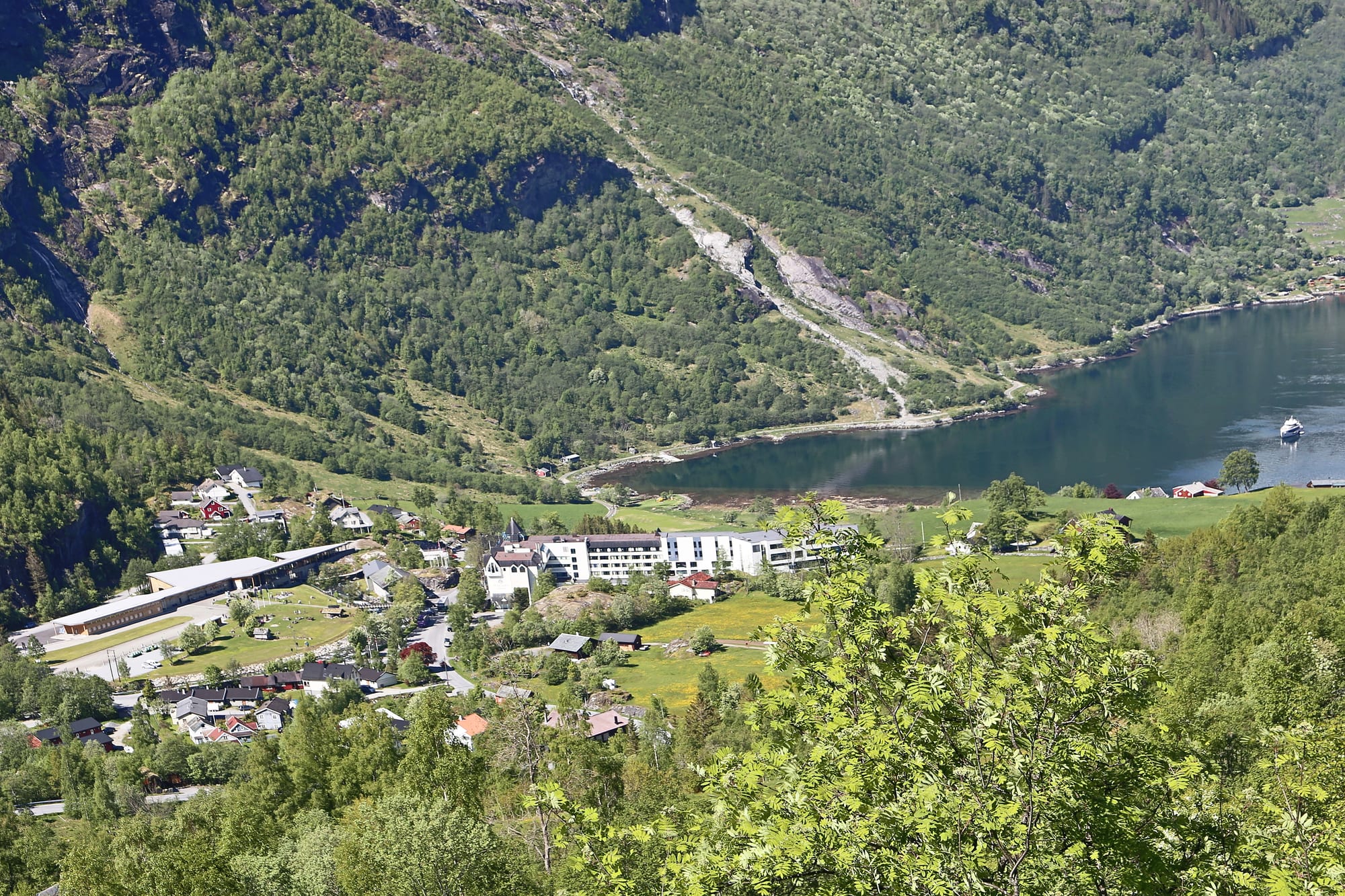
The houses and white buildings of Geiranger among green wooded slopes at the head of a dark blue fjord on a sunny day

Fjord Norway, Norway

Geiranger

Geiranger village at the inner end of the Geirangerfjord, seen from the hillside above. (W. Bulach / Wikimedia Commons · CC BY-SA 4.0)

A village of about two hundred people at the inner end of the Geirangerfjord in Møre og Romsdal, part of the West Norwegian Fjords World Heritage Site. Visitors have come since the 19th century; today cruise ships, coaches and drivers on the hairpin roads of County Road 63 fill its harbour and campsites from May to early September.

Neighbourhoods

  • The harbour and village centre
    • First-time visitors
    • Close to the ferry
    • Cafés

    The flat strip by the water where the Geirangelva river meets the fjord, where a small market was once held at Meråk. The ferry quay, the cruise pier, the tourist information, cafés and souvenir shops all lie within a few minutes' walk, and on busy summer days it is the most crowded part of the village.

    Open in Maps
  • The hillside and the Geiranger valley
    • Views
    • Quieter evenings
    • Walks

    The slopes above the centre along County Road 63, where the octagonal church, scattered farms and the Norwegian Fjord Centre stand above the river. A long stairway beside the waterfall links it with the harbour, and the road climbs on towards Flydalsjuvet and Dalsnibba.

    Open in Maps
  • Hellesylt
    • Quiet and residential
    • Ferry connections

    A small village at the other end of the fjord, at the head of the Sunnylvsfjorden, with its own church, cruise pier and waterfall. The car ferry links it with Geiranger in just over an hour, and roads lead on towards Ålesund and Stryn.

    Open in Maps

Things to do

The fjord and its waterfalls

  • Geirangerfjordattraction

    The 15-kilometre arm of the Storfjorden system, listed with the Nærøyfjord as the West Norwegian Fjords World Heritage Site in 2005, walled by some of the steepest mountains on the west coast.

    Open in Maps
  • Seven Sisters Waterfallattraction

    Seven separate streams falling about 410 metres into the fjord some 6.5 kilometres west of the village, facing the waterfall known as the Suitor on the opposite shore.

    Open in Maps
  • Geiranger–Hellesylt Ferrytransit hub

    The car ferry along the length of the fjord, a trip of about 20 kilometres that passes the main waterfalls and doubles as a sightseeing cruise.

    Open in Maps
  • Waterfall Walktrail

    A stairway of a few hundred steps with railings beside the waterfall that tumbles through the village, rising from the harbour area to the visitor centre on the hillside.

    Open in Maps

Fjord farms and the village

  • Skageflåattraction

    An abandoned goat farm on a ledge about 250 metres above the fjord, lived in from the Middle Ages until 1916, reached by a long walk from the village or by boat and a steep climb.

    Open in Maps
  • Knivsflåattraction

    A pair of old farms beside the Seven Sisters, inhabited since at least the 1600s and abandoned in 1898 because of the danger of rockfall.

    Open in Maps
  • Geiranger Churchlandmark

    A white octagonal wooden church of 1842 on the hillside above the fjord, built after the previous church burned down, with an altarpiece of Christ as comforter from 1902.

    Open in Maps
  • Norwegian Fjord Centremuseum

    A centre at the top of the Waterfall Walk giving an insight into fjord culture, especially life on the abandoned mountain farms along the Storfjorden.

    Open in Maps

Roads and viewpoints

  • Flydalsjuvetviewpoint

    A viewpoint off County Road 63 above the village, giving a closer view than Dalsnibba down over the village, the fjord and the cruise ships.

    Open in Maps
  • Ørnesvingenviewpoint

    The Eagles' Bend, a viewing platform at a hairpin on the road north out of the village towards Eidsdal, looking out over the fjord.

    Open in Maps
  • Dalsnibbaviewpoint

    A mountain at the head of the Geiranger valley, often snow-covered even in summer, whose summit is reached by the Nibbevegen toll road completed in 1939.

    Open in Maps
  • Storsæterfossentrail

    A waterfall in the side valley of Vesteråsdalen above the village, where it is possible to walk behind the falling water.

    Open in Maps

Short trips from the village

  • Trollstigenviewpoint

    The serpentine mountain road with eleven hairpin bends near Åndalsnes, with viewing balconies at the top over the bends and the Stigfossen waterfall.

    Open in Maps

Seasonal events

  • Geiranger – From Fjord to SummitJune

    A half marathon and a cycle race that start at sea level by the fjord and finish on the summit of Dalsnibba, often in snow, which gives the event its other name, 'From Summer to Winter'.

Eat and drink

Long-standing places and food districts in Geiranger. Hours, ratings and directions come from your maps app, always current.

Geiranger cafés and restaurants

  • Village-centre cafésneighborhood

    A cluster of cafés, pizza places and snack bars around the ferry quay and the village centre, aimed at the summer crowds.

    Open in Maps
  • Weserås Restaurantrestaurant

    A small restaurant in the village serving traditional Norwegian food.

    Open in Maps
  • Café Olécafe

    A café in the village centre, a stop for coffee and something to drink.

    Open in Maps

Food on the move

  • Sveler on the ferryrestaurant

    Sveler, thick griddle cakes folded with butter and sugar or brown cheese, have been sold on Møre og Romsdal's fjord ferries since 1971.

    Open in Maps

Experience Geiranger

History

People were in this valley long before the tourists. Stone Age tools have been found on the headland where the Geirangerfjord meets the Sunnylvsfjorden, the farm of Vinje has a burial mound from the Viking Age, and Gjørva, one of the oldest farms, belonged in the Middle Ages to Bakke monastery in Nidaros. At Meråk by the shore, a small market brought fishermen and farmers of Sunnmøre together with traders from the inland valleys. Farms clung to ledges on the fjord walls: Knivsflå was abandoned in 1898 because of the danger of rockfall, Skageflå in 1916 and Blomberg in 1948.

Tourism began in 1869, when a foreign yacht brought what were probably the first photographs ever taken here. By 1895 four hotels were open, and in 1889 the Geiranger road opened over the mountains to the east, served by horse-drawn traffic with up to a hundred horses. Kaiser Wilhelm II of Germany first sailed in in 1899 and returned every summer until 1914, and in the early 1900s a language teacher was hired to promote the place, in the years when the waterfall Knivsflåfossen was renamed the Seven Sisters. In the 1930s Geiranger had a higher density of cars than Oslo, with around fifty open cars carrying visitors up the valley; the toll road to Dalsnibba was finished in 1939, and the Eagle Road to the north in the mid-1950s.

In 2005 the fjord joined the World Heritage list together with the Nærøyfjord. Growth in cruise traffic, which passed 300,000 passengers a year in the 2010s, led to a limit of three ships a day from 2018 and a goal of zero-emission shipping on the fjord by 2026; in 2025 a new floating quay allowed ships of up to 400 passengers to plug in to shore power.

Culture & Customs

Geiranger's culture is shaped by the people who come to see it. Locals once called the village Gjårångjin in their dialect, but the shore was known as Meråk or Merok until the fame of the fjord made Geiranger the only name in use. The best-known waterfall name comes from that tourist era: the Seven Sisters face the Suitor across the water, and the story goes that he is still trying to woo them, while a third fall is called the Bridal Veil.

The fjord has also travelled the world on screen. The disaster film The Wave (Bølgen), released in 2015, imagines a rockslide from Åkerneset sending a wave into the village, and the landscapes of the Geirangerfjord and the Nærøyfjord helped inspire the kingdom of Arendelle in Frozen. Older visitors left their mark too: Henrik Ibsen's mother-in-law, Magdalene Thoresen, wrote of mountains so steep that the fjord had no habitable shore, and of farms reached by paths around precipices and bridges bolted to the rock.

Local life follows the church, the farms and the season. The octagonal church of 1842, decorated by the woodcarver Einar Flydahl for its centenary, serves the parish, and some of the abandoned fjord farms have been restored by the Storfjordens venner association. In June the village hosts a race from the fjord to the summit of Dalsnibba, often run into snow.

Daily Life

The village had about 215 residents in 2023, and since 2000 Statistics Norway has not tracked its population separately. It belongs to Stranda Municipality, whose centre is the small town of Stranda on the Storfjorden. A large share of the people who live here year-round work in tourism, which is the village's main business.

The year has two halves. From May to early September several hundred thousand people pass through, many arriving on cruise ships that anchor or tie up at the floating pier, so that a village of a couple of hundred residents can see thousands of visitors a day. Campsites, cabins and hotels fill, the ferry to Hellesylt runs several times a day and coaches climb the hairpins. Through the winter most of the visitors are gone, the mountain road to the south is closed, and life returns to a small rural parish at the foot of the mountains.

Living here also means living with risk. The mountain Åkerneset, on the Sunnylvsfjorden, is moving slowly towards the water, and a collapse could produce a wave that would reach Geiranger and Hellesylt within about ten minutes; warning sirens are in place. Other debates concern the number of visitors itself: a fee for tourists was proposed in 2020 to manage traffic and raise money for local services.

Food

Geiranger eats as the rest of western Norway does, from the sea and the mountain pastures. Salted and dried cod, klippfisk, literally "cliff-fish" because it was once dried on bare rock, is still dried outdoors in western and northern Norway, mainly for export. Potato dumplings known in Vestlandet as raspeball or komle, made from grated potato and flour and served with salted meat, butter or mashed swede, appear on Thursdays at cafés that serve local food. In early autumn many Norwegians eat fårikål, the national dish of mutton on the bone stewed for hours with cabbage and whole black pepper.

Brown cheese, brunost, a sweet whey cheese whose colour comes from caramelised milk sugar, goes on bread, waffles and sveler. The svele, a thick griddle cake folded in half with butter and sugar or brown cheese, belongs to Møre og Romsdal in particular: since 1971 it has been sold on the ferries that cross the region's fjords, and it remains part of a crossing on the boats around Geiranger.

The village itself is small, and most of what it offers is café food for the summer crowds: coffee and cakes, pizza and sandwiches near the quay, and a few restaurants serving traditional Norwegian dishes. Larger towns such as Ålesund have the supermarkets and the wider choice, so self-caterers often stock up before driving in.

Planning tools

Budget

Geiranger is a famous place in an expensive country, and its prices reflect both. Rooms in summer are scarce and costly, cafés serve a captive audience, and boat trips, kayak hire and the Dalsnibba toll road add up. Campsites and cabins are the main way to save, and the village's walks and the waterfall stairway cost nothing.

Daily Budget Midrange
USD 270–480 (fjord hotel, restaurant dinners, a fjord cruise or kayak trip, a hire car)
Daily Budget Shoestring
USD 95–160 (campsite or cabin share, supermarket food, the ferry and summer buses)

Book summer rooms and campsite cabins well ahead, and buy food in a larger town on the way in.

Best Time to Visit

The tourist season runs from May to early September. Late May and June bring the strongest waterfalls from snowmelt and snow still lying on Dalsnibba; July is the busiest month, when the number of cruise ships in port is capped at three a day. The Geiranger road over the mountains to the south is usually closed from early November to late May.

Suggested Number of Days

A night or two covers the village, the fjord and the viewpoints above it. Three or four days allow time for the longer hikes, the far end of the fjord and the scenic route north. Low cloud can hide the mountains for a day, so a spare day is worth having.

First Visit
1–2 days
With Surroundings
3–4 days

Transportation

County Road 63 runs through the village, climbing south over the Geiranger road towards Langvatn and north over the Eagle Road to a short ferry at Eidsdal; the southern section closes in winter and spring, leaving the Eagle Road as the year-round link. A car ferry runs along the fjord to Hellesylt, and in summer a bus line runs up to Dalsnibba. Sightseeing boats, kayaks and tour buses cover the rest.

On the hairpin roads, expect long queues behind coaches and camper vans in July and use low gears on the descent.

Airport & Station Connections

The nearest airport is Ørsta–Volda Airport, Hovden, roughly an hour and fifty minutes away by road; Ålesund Airport is the larger alternative. The nearest railway stations are Åndalsnes, at the end of the Rauma Line, and Otta on the Oslo–Trondheim line, both linked by road in summer. Many visitors arrive on cruise ships, on the Hurtigruten coastal service in summer, by car over the mountain roads or by the ferry from Hellesylt.

Walkability

The centre is tiny and walkable, but it lies at the bottom of a steep valley: everything above the harbour, including the church and the visitor centre, is uphill, and the waterfall stairway is the easiest way up. Roads have no pavement in places and carry heavy coach and camper traffic in summer.

Safety

Norway has among the lowest crime rates in the world. In Geiranger the risks are natural rather than criminal: steep paths, rockfall, sudden changes in mountain weather and narrow roads crowded with coaches. The mountain Åkerneset, on the Sunnylvsfjorden to the west, is unstable, and sirens have been installed in the village to warn of a landslide that could send a wave up the fjord.

Take warning sirens seriously and follow local instructions, keep to marked paths and behind railings at waterfalls, and carry warm, waterproof layers on hikes. Check current official travel advice before travelling.

Climate

Geiranger gets markedly less rain than places nearer the sea, because the Sunnmøre Alps to the west catch some of it, and the neighbouring villages of Tafjord and Norddal record under 1,000 mm a year. Winter weather is unsettled, and large amounts of snow gather on the mountain passes towards Stryn and Skjåk.

Summer
mild and changeable; inland valleys and the innermost fjords see the warmest summer days, and the neighbouring village of Tafjord holds the Møre og Romsdal record of 33.8°C, set in July 1945
Winter
snowy and dark in the valley, with deep snow on the passes and the road south over the mountains closed; warm foehn winds can bring sudden mild spells, and neighbouring Tafjord has recorded 17.9°C in January

Local Customs

Norwegian manners are egalitarian and understated: first names are used for everyone and hierarchies are flat. Much of the land around the village is farmland, so visitors keep to paths and close gates behind them. The church is a working parish church, and quiet behaviour inside is expected.

Drinks stronger than 4.75 per cent alcohol are sold only by the state retailer Vinmonopolet, and alcohol is heavily taxed; ask before photographing people at work on farms.

Common Payment Methods

The currency is the Norwegian krone (NOK). Cards and contactless payment are widely used, and the Vipps app, Norway's largest payment application, is common.