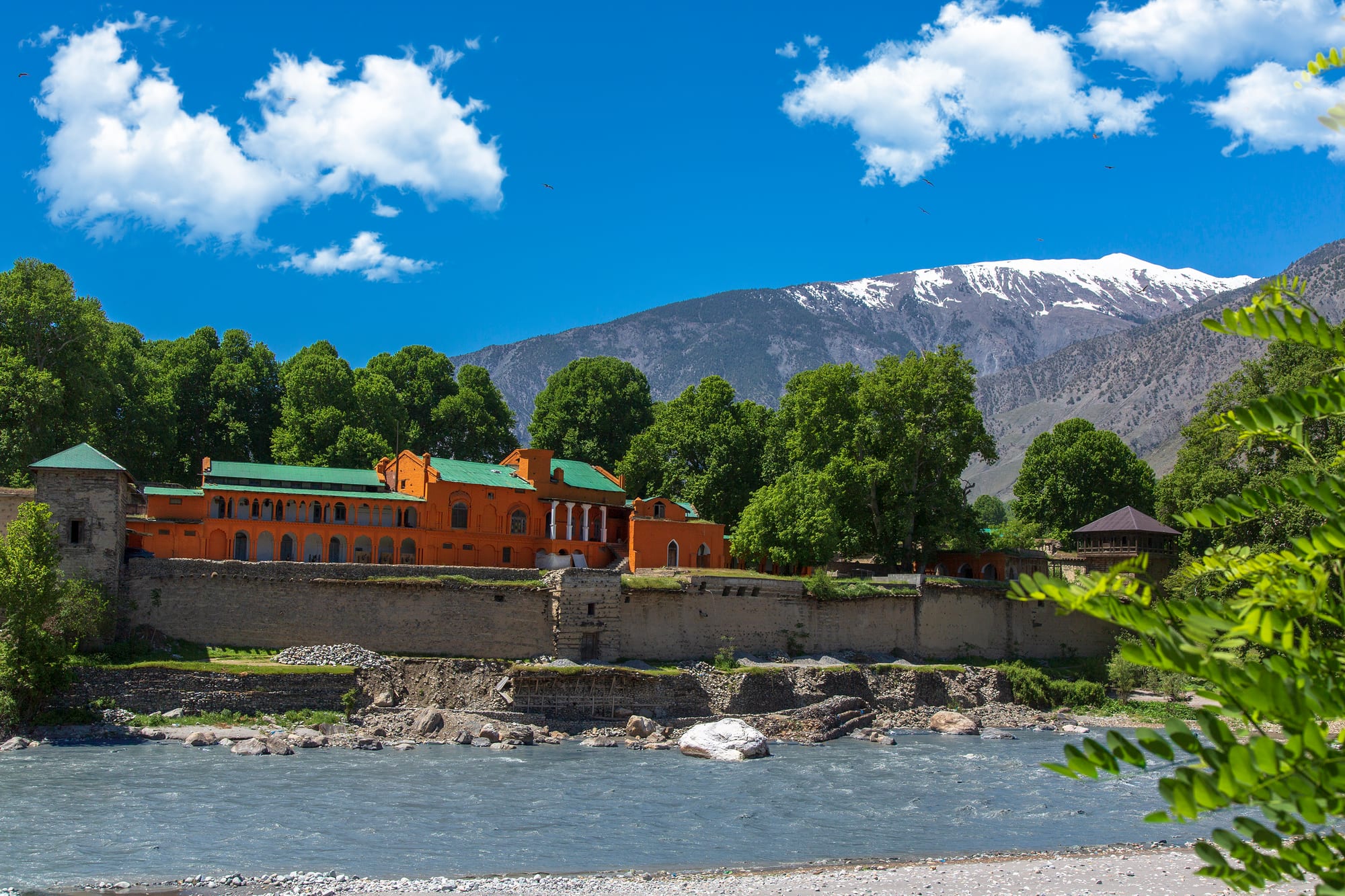
A long orange-walled fort with green roofs standing behind a stone wall above a grey river, with a snow-capped mountain behind

Peshawar & Khyber Pakhtunkhwa, Pakistan

Chitral

Chitral Fort on the bank of the Chitral River, with the Hindu Kush rising behind the town. (Tahsin Shah / Wikimedia Commons · CC BY-SA 4.0)

A mountain town in the far north-west of Khyber Pakhtunkhwa, strung along the Chitral River beneath Tirich Mir, the highest peak of the Hindu Kush. Capital of a princely state until 1969, it keeps its riverside fort and royal mosque, speaks Khowar rather than Pashto, and serves as the way into the Kalash valleys. This page is written to explain the town, not to encourage travel.

Neighbourhoods

  • The bazaar and town centre
    • First-time visitors
    • Markets
    • Local life

    A single main street of shops, tea houses and transport offices running parallel to the river, where the valley comes to buy and sell. Most of the town's hotels and the jeep stands for the Kalash valleys and the north are within a few minutes' walk of it.

    Open in Maps
  • The fort and Shahi Masjid quarter
    • Historic district
    • Riverside

    The riverside ground at the lower end of town where the walled fort of the former rulers stands beside the white-and-yellow royal mosque, with the polo ground and older houses nearby. It is the quietest and most photogenic part of Chitral.

    Open in Maps
  • Danin and the airport side
    • Quiet and residential
    • Close to transport

    Spread-out residential ground north of the centre towards the airstrip, with orchards, guest houses and newer concrete houses among the fields. Views of Tirich Mir open up from the higher lanes on clear mornings.

    Open in Maps

Things to do

In the town

  • Chitral Fortlandmark

    The riverside fort of the mehtars, rulers of Chitral, built in 1774 and restored in 1911, and famous as the place besieged in 1895 during the Chitral Expedition, with towers of stone and timber above the water.

    Open in Maps
  • Chitral Museummuseum

    The town's museum, opened in 2010, with an ethnological gallery of Chitrali embroidery, jewellery, instruments and household objects and a second gallery of archaeological finds and Kalasha material, including wooden effigies.

    Open in Maps
  • Chitral polo groundattraction

    The ground in the centre of town where the free-tackling mountain form of polo is played through the summer, watched from the surrounding walls.

    Open in Maps

Valleys and mountains nearby

  • Chitral Gol National Parkpark

    A protected side valley west of the town, rising into high pasture and cliffs that hold one of Pakistan's better-known markhor populations.

    Open in Maps
  • Tirich Mirviewpoint

    At over 7,700 metres the highest peak of the Hindu Kush, visible from parts of the town and from the road north.

    Open in Maps
  • Garam Chashmaattraction

    A village of hot sulphur springs in a side valley about 45 kilometres north-west, long used as a bathing place.

    Open in Maps
  • Ayunattraction

    A green orchard village south of the town where the road turns off for the Kalash valleys.

    Open in Maps

The Kalash valleys

  • Kalash Valleysattraction

    Bumburet, Rumbur and Birir, the three side valleys south-west of Chitral where the Kalasha people keep a polytheistic religion, their own language and distinctive dress.

    Open in Maps
  • Bumburetattraction

    The largest and most visited of the Kalash valleys, a walnut- and mulberry-shaded valley of wooden houses reached by the road that turns off at Ayun, about 35 kilometres from Chitral.

    Open in Maps

Roads out of the valley

  • Lowari Passattraction

    The pass south towards Dir that long cut Chitral off each winter, now bypassed by the Lowari tunnel, over 8 kilometres long, which opened in 2017.

    Open in Maps
  • Droshattraction

    A bazaar town down the valley on the road to the Lowari tunnel, the largest town of Lower Chitral district after Chitral itself.

    Open in Maps

Seasonal events

  • Chilam Joshimid-May

    The Kalasha festival marking the start of spring, held from about 13 to 16 May across the Kalash valleys, with song, dance and new clothes; Bumburet draws the most visitors.

  • ChawmosDecember

    The Kalasha winter solstice festival, the high point of their religious year, held over two weeks in the first half of December, the first of them closed to outsiders.

  • Summer polo seasonsummer

    Matches on the Chitral ground and in villages up the valley, played in the mountain style with few rules and a band beside the pitch.

Eat and drink

Long-standing places and food districts in Chitral. Hours, ratings and directions come from your maps app, always current.

Chitrali kitchens

  • Bazaar tea housesrestaurant

    Small kitchens along the main street serving rice, beans, mutton and fresh bread, with pots of tea kept going through the day.

    Open in Maps
  • Chitral bazaar food shopsmarket

    Dried apricots, walnuts, mulberries, local cheese and honey from the side valleys are sold by weight among the cloth and hardware shops.

    Open in Maps
  • Trout restaurants by the riverrestaurant

    Trout from the Chitral River and its tributaries, fried or grilled whole, served at riverside hotels and restaurants.

    Open in Maps

Experience Chitral

History

Chitral was the seat of a mountain state whose rulers, the mehtars of the Kator dynasty, held the upper Chitral valley for centuries, with the princely capital beside the river where the fort still stands. The valley sat on routes between Central Asia, Afghanistan and Kashmir, and its rulers balanced larger powers around them while collecting tribute from the side valleys. Islam spread through the region relatively late, and pockets of the older religion survived in the Kalash valleys, where they remain.

In 1895 a succession dispute left a British force of some 400 men besieged in the fort until it was relieved by two expeditions, a small one from Gilgit and a larger one from Peshawar. The episode, known as the Chitral Expedition, made the valley famous in Britain and brought it under British influence as a princely state, with a road and a political agency attached to it. The state kept its own ruler until it was merged into Pakistan in 1969, after which Chitral became a district of the North-West Frontier Province, later Khyber Pakhtunkhwa.

For most of the 20th century the town was cut off by snow for several months each year, reachable only by air or by the Shandur Pass. The Lowari tunnel, begun in 1975 and finally inaugurated in 2017, ended that isolation and made year-round road travel possible. Floods in 2015 and again in later years washed away bridges, roads and irrigation channels, and the district was divided into Upper and Lower Chitral in 2018.

Culture & Customs

Chitral is not Pashtun country. The language of the town is Khowar, and Chitralis see themselves as distinct from the Pashto-speaking districts to the south: quieter in manner, proud of their musical tradition and of a reputation for courtesy towards strangers. Several smaller languages are spoken in the side valleys, and the Kalasha language survives in three of them.

Polo is the passion of the valley, played in a free-tackling mountain form with few rules, six to a side and a band of drums and the surnai, a shrill reed pipe, playing beside the pitch. Every summer villages field teams, and the Shandur Pass, high to the east, hosts a tournament between Chitral and Gilgit that has become nationally known. Chitrali music uses the sitar, a local long-necked lute quite unlike the Indian instrument, and songs and sung poetry in Khowar are performed at weddings and gatherings.

The pakol, the rolled woollen cap, is the everyday headgear and a marker of identity well beyond Chitral. The Kalasha community in the valleys nearby keeps a separate religion, with wooden temples, ancestor effigies and seasonal festivals that draw visitors from across Pakistan. Relations between the communities are generally settled, and Chitralis of both faiths tend to describe the valley's tolerance as part of its character.

Daily Life

About 57,000 people live in Chitral town, the largest settlement in a district of scattered villages spread along the river and its tributaries. Livelihoods come from irrigated farming on terraces — wheat, maize, potatoes, apricots, apples and walnuts — from livestock taken to high pasture in summer, from government and army employment, and from remittances sent by Chitralis working in Peshawar, Karachi and the Gulf. Tourism from elsewhere in Pakistan has grown and supports jeep drivers, guest houses and guides.

The day is short in winter, when snow and long nights slow everything, and busy in summer, when the bazaar fills from mid-morning and jeeps come down from the side valleys loaded with people and produce. Shops close for Friday prayers. Households heat with wood, and firewood collection is a constant task.

The district's difficulties are physical as much as economic. Roads and bridges are regularly destroyed by floods and landslides, glacier lake outbursts threaten some valleys, electricity from small hydropower plants is intermittent, and hospitals are far away for anyone in the upper valleys. Depopulation of the remoter villages towards the towns and the plains continues, and young people leave for education and work.

Food

Chitrali cooking is plain mountain food built on wheat, dairy and what the orchards give: honey, cheese and fruit are staples of the local diet. Ghalmandi, layered flatbreads with a filling of cottage cheese, coriander and chives under melted butter and walnut oil, is the dish most associated with the valley, and a range of breads is baked daily, among them the sweet rishiki eaten with honey and cottage cheese. Kalli, a soup of hand-cut whole-wheat noodles with minced meat, belongs to the older household repertoire.

Dairy matters more here than in the plains: butter is clarified and kept, cheeses are made in the summer pastures, and yoghurt accompanies most meals. Meat is usually mutton or goat, eaten sparingly and often boiled rather than fried, with soups and broths common in winter. Trout from the Chitral River and its clear tributaries is the treat of the summer season, fried or grilled whole. Kabuli pulao and karahi appear in the bazaar restaurants, brought in from the wider Pashtun and Afghan tradition.

The orchards supply the sweet side of the diet: apricots, mulberries, apples, grapes and walnuts are eaten fresh in season and dried for the winter, and apricot kernels are pressed for oil. Tea is drunk constantly — sweet milk tea in the bazaar, and in some households a salted tea of the kind found across the high valleys of the Hindu Kush and Karakoram.

Planning tools

Budget

Costs in Chitral are low, but getting there and moving around are not. Guest houses and bazaar meals are cheap, while jeep hire for the Kalash valleys, Garam Chashma or the high side valleys is the main expense, and fuel this far from the plains is dear. A small entry fee is charged to visitors going into the Kalash valleys.

Daily Budget Midrange
USD 45–100 (good hotel, restaurants, a car or jeep with driver)
Daily Budget Shoestring
USD 12–25 (guesthouse, bazaar food, shared jeeps and vans)

Bring cash from Peshawar or Islamabad; ATMs exist in town but can be out of service, and cards are rarely accepted.

Best Time to Visit

May to October, when the roads and side valleys are open, the orchards are in fruit and polo is played. Spring brings the Kalasha Chilam Joshi festival; autumn is clear and cool with good views of Tirich Mir. From December to March snow closes the higher valleys and makes travel slow, though the Lowari tunnel keeps the road south open in most conditions.

Suggested Number of Days

The town itself is small and a day or two covers it. Allow four to six days to include the side valleys, which involve slow jeep journeys, and add spare time, since weather and road closures regularly change plans.

First Visit
1–2 days
With Surroundings
4–6 days

Transportation

The town is walkable, and everything beyond it means a jeep. Shared vehicles and hired jeeps leave the bazaar for Bumburet, Garam Chashma, Mastuj and the villages up the valley; long-distance vans and coaches run south through the Lowari tunnel to Dir, Peshawar and Islamabad. Roads are narrow, unsurfaced in places and prone to landslides.

Hire a jeep with a local driver for the side valleys, travel only by daylight, and allow much more time than the distances suggest.

Airport & Station Connections

Most people arrive by road from Islamabad or Peshawar, a long day's drive of roughly 12 to 14 hours through Dir and the Lowari tunnel. Chitral Airport, a few kilometres north of the town, has a limited service to Islamabad, resumed in 2025 after a gap of about three years and subject to mountain weather. In summer a rough high road crosses the Shandur Pass from Gilgit-Baltistan.

Walkability

Chitral is small enough to cross on foot in half an hour, and the bazaar, the fort, the mosque and the polo ground are all within easy walking distance of each other along the river. Streets are dusty, narrow and shared with jeeps, and the ground rises steeply away from the river, so walks to the outlying lanes are harder work than the map suggests.

Safety

Security varies more in Khyber Pakhtunkhwa than anywhere in Pakistan. Militant activity in the province has increased since 2021, and Chitral district borders Afghanistan, including the narrow Wakhan corridor; the district has generally been calmer than the border districts further south, but foreigners may be required to register with police or to accept an escort, and checkpoints are usual on the roads. Mountain roads, landslides and winter weather are the other real hazards.

Follow police and security instructions, keep well away from the Afghan border, travel between towns by daylight, and dress and behave conservatively. Check current official travel advice before travelling.

Climate

A dry mountain climate in a deep valley at around 1,500 metres. Summers are warm and dusty by day and cool at night; winters are cold with snow, and the high passes close. Rainfall is low, most of it falling in spring, and the river runs high with snowmelt in early summer.

Summer
warm and dry, roughly 20–35°C by day, cooler in the side valleys
Winter
cold, roughly minus 3 to 10°C, with snow in the town and deep snow above it

Local Customs

Khowar is the language of the town, and Chitralis are known in Pakistan for a reserved, courteous manner; the woollen Chitrali cap, or pakol, is worn everywhere. Society is conservative and Muslim, with both Sunni and Ismaili communities in the district. The Kalasha of the nearby valleys have their own religion and customs and are used to visitors, but their festivals are religious occasions rather than shows.

Dress modestly, ask before photographing anyone and especially Kalasha women, take off shoes at mosques and shrines, and do not bring alcohol; hospitality offered by hosts is best accepted.

Common Payment Methods

The currency is the Pakistani rupee, and Chitral runs on cash. A few banks and ATMs operate in the town, but they can be empty or offline, and there are none in the Kalash valleys or the villages up the valley. Only the larger hotels take cards.