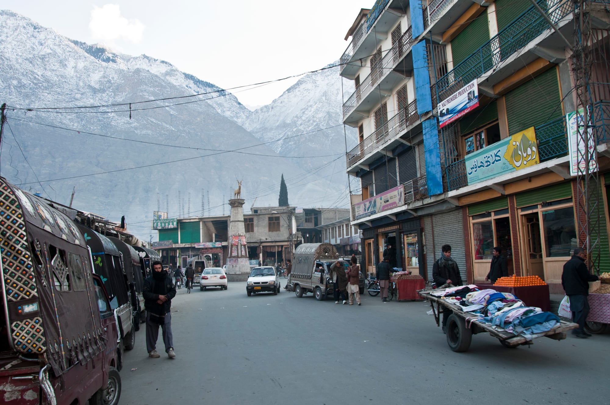
A wide bazaar street with parked minibuses, shopfronts and a monument, ending at snow-streaked brown mountains

Gilgit-Baltistan & Azad Kashmir, Pakistan

Gilgit

A bazaar street in Gilgit, with the mountains of the valley closing the view. (Ndwarraich / Wikimedia Commons · CC BY-SA 3.0)

The administrative centre of Gilgit-Baltistan, set where the Gilgit river joins the Hunza river in a dry valley ringed by bare mountains. A crossroads of the old Silk Road and later of the Great Game, it is today the region's bazaar, transport hub and university town on the Karakoram Highway. This page is written to explain the city, not to encourage travel.

Neighbourhoods

  • Gilgit Bazaar
    • First-time visitors
    • Local life
    • Best for food

    The central grid of market streets around Shahrah-e-Quaid-e-Azam, with cloth and hardware shops, dried-fruit stalls, jewellers, bakeries and small kitchens. Minibuses and jeeps for the valleys leave from the yards behind it, and it is the busiest part of the city by day.

    Open in Maps
  • Jutial
    • Quiet and residential
    • Hotels

    The south-eastern end of the city, where wider streets, government housing and hotels sit against the mountain slope. A walking track climbs behind it to the nullah and the tree line, a common local outing.

    Open in Maps
  • Konodas and the riverside
    • Views
    • Walks

    The quarter along the Gilgit river below the bazaar, where bridges cross to the north bank and the water runs grey with glacial silt. The views back across the city towards the peaks are the best in town.

    Open in Maps
  • Danyore
    • Local life
    • Quiet and residential

    A separate settlement across the Hunza river to the east, reached by bridge, with orchards, terraced fields and its own bazaar. The Karakoram Highway passes through on its way north towards Hunza.

    Open in Maps
  • Napura and the airport road
    • Close to the airport
    • Practical base

    The western approach to the city, with the airport, offices and newer housing spread along the valley floor. It is plain and functional rather than scenic, but convenient for early flights and for the road to Punial and Ghizer.

    Open in Maps

Things to do

Landmarks and history

  • Kargah Buddhalandmark

    A standing Buddha some fifteen metres high carved into a cliff face in Kargah Nala, about ten kilometres west of the city, and thought to date from the seventh century, when Gilgit was a Buddhist centre.

    Open in Maps
  • Gilgit Riverattraction

    The river that gives the city its name, joining the Hunza river just downstream and then the Indus, with suspension bridges and riverside paths at Konodas.

    Open in Maps
  • Karakoram International Universityattraction

    The region's main university, founded in 2002, with its main campus on University Road and satellite campuses in Skardu and Hunza; it is the reason much of Gilgit-Baltistan's student population lives in the city.

    Open in Maps
  • Gilgit Airporttransit hub

    The small valley airport on the western edge of town, whose flights from Islamabad thread between mountain walls and are cancelled whenever cloud closes the route.

    Open in Maps

Short trips from the city

  • Naltar Valleyattraction

    A forested side valley about 34 kilometres north-west of Gilgit, known for its pine woods, its alpine lakes and a small ski resort used for national competitions.

    Open in Maps
  • Rakaposhiviewpoint

    The broad Karakoram peak north of the city, the twenty-seventh highest in the world, seen from viewpoints on the Karakoram Highway where its glacier descends close to the road.

    Open in Maps
  • Hunza Valleyattraction

    The terraced valley north along the Karakoram Highway, with the forts of Karimabad, apricot orchards and the peaks of upper Hunza beyond.

    Open in Maps
  • Nanga Parbatviewpoint

    The 8,126-metre western anchor of the Himalaya, south of the city, visible from points along the Indus road and approached from Raikot Bridge.

    Open in Maps

Seasonal events

  • NavrozMarch

    The Persian new year, widely marked in Gilgit and the surrounding valleys with family visits, special dishes, music and sports.

  • Muharram and Ashuravaries with the Islamic calendar

    Gilgit has a large Shia population and the mourning processions of Muharram are the most significant religious observance of the year.

  • Shandur Polo FestivalJuly

    The annual tournament between Gilgit and Chitral teams on the Shandur Pass, played at about 3,700 metres in the free-wheeling local style; Gilgit's own polo ground hosts matches through the summer.

  • Gilgit-Baltistan Independence Day1 November

    The anniversary of the 1947 uprising that ended Dogra rule in Gilgit, marked with parades, speeches and sports events.

Eat and drink

Long-standing places and food districts in Gilgit. Hours, ratings and directions come from your maps app, always current.

Gilgit classics

  • Bazaar kitchens and tikka shopsrestaurant

    The market streets are lined with small grills and kitchens serving mutton tikka, karahi, dal, rice and fresh naan to traders, drivers and students.

    Open in Maps
  • Chapshuro and northern dishesrestaurant

    The meat-filled Hunza bread chapshuro and dumplings called mamtu are sold in the city as well as in the valleys, alongside buckwheat breads and mountain soups.

    Open in Maps
  • Tea shopscafe

    Green tea, sweet milk tea and, in Balti households, salted butter tea are drunk through the day, usually with dried apricots, walnuts and bread.

    Open in Maps

Markets

  • Gilgit Bazaarmarket

    The main market of the whole region, selling dried apricots, mulberries, walnuts, apricot oil, honey and woollen caps beside everyday goods and trekking supplies.

    Open in Maps

Experience Gilgit

History

Gilgit was Buddhist for centuries, a staging post on the branch of the Silk Road that crossed from the Tarim basin over the passes towards Kashmir and Swat. The rock-cut Buddha at Kargah, about ten kilometres west, and the Gilgit manuscripts — birch-bark Buddhist texts discovered near the town in 1931 and among the oldest manuscripts in the world — belong to that period. Islam spread through the valleys from around the 14th century, and local dynasties, the Trakhan rulers of Gilgit among them, governed small mountain states that fought and allied with Hunza, Nagar, Chitral and Baltistan.

In the 19th century the valley was drawn into the rivalry between the British and Russian empires. The Dogra rulers of Jammu and Kashmir gained Gilgit under the 1846 Treaty of Amritsar, and the British, guarding against Russian advance, established the Gilgit Agency in 1877, later re-established under the British Resident in Jammu and Kashmir, with the locally raised Gilgit Scouts as its force. It was from here that the campaign against Hunza and Nagar was launched in 1891, and from here that the frontier was watched.

In late 1947, after the Maharaja of Kashmir acceded to India, the Gilgit Scouts and local leaders overthrew his governor on 1 November and the territory came under Pakistani administration, an anniversary still marked in the city. Gilgit became the headquarters of the Northern Areas, renamed Gilgit-Baltistan in 2009, though the region's constitutional status remains unresolved and India claims it as part of the former princely state. The Karakoram Highway, completed with China in the late 1970s, turned the town into the region's transport hub, and a university, hospitals and government offices followed.

Culture & Customs

Gilgit is the meeting point of the region's languages. Shina is the main tongue of the city and the surrounding valleys, Burushaski is heard from Hunza and Nagar, Balti from Skardu, Wakhi and Khowar from the western and northern valleys, and Urdu serves as the common language of trade, school and government. That mixture makes the bazaar one of the most linguistically varied market streets in Asia.

Religion is equally mixed. Shia, Sunni and Ismaili communities all live in the city, each with its own mosques, imambargahs and jamatkhanas, and Gilgit-Baltistan is the only Shia-plurality part of Pakistan. Relations have at times been strained, and the calendar of Muharram is observed with large processions. Ismaili institutions, especially the Aga Khan network, run many schools and clinics in the surrounding valleys, and literacy rates in the region are high by national standards.

Polo is the defining sport, played in the fast freestyle form with few rules, a band of drums and shawms at the side of the ground and crowds along the walls; the summer tournament against Chitral on the Shandur Pass is the fixture everyone follows. Folk music uses the drum, the surnai shawm and the six-stringed rubab, and crafts include woollen patti cloth, embroidered woollen caps worn by men across the region, and gemstone cutting. Manners are formal: greetings before business, tea before conversation, and modesty in dress and behaviour.

Daily Life

Gilgit is the most populous city in Gilgit-Baltistan, and its district counted some 325,000 people at the 2023 census. It is the destination for families from every valley who come for hospitals, schooling, government offices and the university. The population swells during term time with students, and in summer with traders, tourists and expedition crews passing through.

The economy is built on government service, the army, transport and trade. Goods for the whole region are unloaded here from the Karakoram Highway and redistributed by jeep and minibus; dried fruit, gemstones and handicrafts move in the other direction. Farming continues on irrigated terraces around the city, with apricots, apples, cherries and vegetables, and tourism supports hotels, drivers and guides from May to October.

Days begin early, with transport leaving for the valleys soon after dawn and the bazaar busy by mid-morning; the heat of a summer afternoon empties the streets until evening. Winter brings quiet, power cuts and cold, though the city stays open when the high valleys close. Current concerns include electricity and flour prices, landslide and flood risk, water supply, the lack of full constitutional status for the region, and the pace at which tourism is changing land use in the valleys nearby.

Food

Gilgit eats a mixture of mountain and national cooking. From the valleys come chapshuro, a griddle-cooked bread filled with minced meat and onion; mamtu, steamed dumplings served with yogurt or sauce; buckwheat and barley breads eaten with apricot oil or butter; and thick flour-based soups for the cold months. From the rest of Pakistan come the tikka shops, karahi pans, dal, pilau and tandoori naan that fill the bazaar, cooked for drivers and traders rather than visitors.

Dried fruit is the region's signature product and the bazaar is the place to buy it: apricots dried whole or in halves, mulberries, walnuts, almonds, apricot kernels and apricot oil, along with honey from the valleys. Fresh fruit follows the short season — cherries and apricots in early summer, then apples, pears and grapes — and much of it is sold from handcarts in the market streets.

Tea marks the rhythm of the day. Green tea, often with cardamom, is the usual offering; sweet milk tea is drunk in the shops; and Balti families make the salted butter tea of Tibetan tradition. Alcohol is not sold. Bakeries turn out tandoori bread through the day, and sweets such as halwa and barfi appear at weddings and festivals, when whole neighbourhoods cook together.

Planning tools

Budget

Gilgit is cheaper than the tourist valleys north of it, since it is a working town rather than a resort, though everything is still trucked up the Karakoram Highway. Simple hotels and bazaar food cost little, while jeep hire for the side valleys and domestic flights are the expensive items. Prices rise in July and August with domestic tourism.

Daily Budget Midrange
USD 55–130 (good hotel, restaurant meals, a jeep with driver or a flight from Islamabad)
Daily Budget Shoestring
USD 15–30 (basic hotel, bazaar food, shared minibuses)

Gilgit is the best place in the region to draw cash and buy supplies before heading into the valleys.

Best Time to Visit

April to October. Spring brings blossom in the surrounding orchards, the summer months open the jeep tracks to Naltar and the passes towards Ghizer and Chitral, and autumn is clear and settled. Summer days on the valley floor are hot and dusty; winter is cold and quiet, with snow on the high roads.

Suggested Number of Days

A day or two covers the city itself, which most travellers treat as a base or a staging post. Four or five allow the side valleys nearby and the road north. Flight cancellations and landslides regularly add time to any plan made here.

First Visit
1–2 days
With Surroundings
4–5 days

Transportation

The bazaar area is walkable and cheap taxis and shared Suzuki pick-ups cover the rest of the city. Minibuses and jeeps to Hunza, Skardu, Ghizer and the side valleys leave from yards near the bazaar, mostly early in the morning, and long-distance coaches run down the Karakoram Highway to Islamabad. Hired jeeps with drivers are the usual way to reach the mountain valleys.

Transport to the valleys departs early and fills up; arrange it the day before through a hotel or at the bazaar yards.

Airport & Station Connections

Flights from Islamabad take about an hour and land in the valley, but are often cancelled in cloud. By road, the Karakoram Highway runs from Islamabad up the Indus in a long day and a half or more, with the Babusar Pass a shorter summer alternative; Skardu lies east along the Indus and Karimabad north up the highway, each several hours away by road.

Walkability

The bazaar is compact and easy to walk, and the riverside at Konodas is a pleasant stroll. Beyond that the city stretches several kilometres along the valley, pavements are patchy and traffic is heavy on the main road, so most people use taxis between districts. The altitude is not a problem in itself.

Safety

Gilgit-Baltistan is among the safest parts of Pakistan for visitors, and the main dangers are natural: landslides and rockfall on the highways, flash floods, and road accidents on mountain roads. Gilgit has seen sectarian tension and occasional violence in the past, which has sometimes brought curfews, though visitors are not the target; checkposts record passport details and some border areas require permits.

Keep passport copies for checkposts, avoid large gatherings and processions, travel mountain roads in daylight, and ask locally before setting out after heavy rain. Check current official travel advice before travelling.

Climate

A cold desert climate on the valley floor, sheltered from the monsoon by the ranges. Summers are hot and dusty on the valley floor, with cool nights; winters are cold but far milder than in the high valleys, and rainfall is low all year.

Summer
hot and dry — daytime temperatures often in the mid 30s °C and occasionally over 40 °C, with much cooler evenings
Winter
cold — daytime highs commonly around 5 to 10°C and nights below freezing, with occasional snow in the city

Local Customs

Gilgit is more conservative than the Hunza valley and religiously mixed, with Shia, Sunni and Ismaili communities in the same city. Modest dress is expected, including covered arms and legs and a headscarf for women, and restraint around religious buildings and processions is important. Shina is the main local language, with Burushaski, Balti and Urdu also spoken. Hospitality is generous and tea is always offered.

Ask before photographing people, mosques or processions; avoid discussing sectarian politics; alcohol is not available; and dress conservatively in the bazaar.

Common Payment Methods

The currency is the Pakistani rupee and cash is used for almost everything. Gilgit has the region's most reliable banks and ATMs, which can still run out of notes or lose connection, and card payment is limited to a few larger hotels. Most travellers stock up on rupees here before going into the valleys.