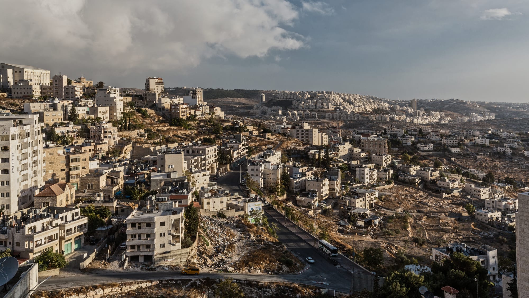
Pale stone houses and apartment blocks covering a ridge in Bethlehem, with bare hillsides and more building beyond

Palestine

Bethlehem

Bethlehem spreading across its hills in the southern West Bank. (Lux Moundi / Wikimedia Commons · CC BY-SA 2.0)

A hill town about 10 kilometres south of Jerusalem, in the West Bank, built around the Church of the Nativity over the traditional birthplace of Jesus. Pilgrimage has shaped its trade since the fourth century, and olive-wood carving and mother-of-pearl work with it. The separation barrier now runs along its northern edge. This page is written to explain the city, not to encourage travel.

Neighbourhoods

  • Manger Square and the Old City
    • First-time visitors
    • Historic district
    • Pilgrimage

    The paved square in front of the Church of the Nativity, with the Mosque of Omar on one side and the town hall and tourist office on the other. The lanes behind it hold the old souk, olive-wood and mother-of-pearl workshops, guesthouses and most of the restaurants a visitor will use.

    Open in Maps
  • Star Street
    • Historic district
    • Quiet walks

    The old pilgrims' approach from the north, a narrow stepped street of vaulted passages, family houses and small shops running down to Manger Square. It is part of the UNESCO-listed pilgrimage route and much quieter than the square itself.

    Open in Maps
  • Beit Sahour
    • Local life
    • Best for food
    • Shepherds' Fields

    A separate town immediately east and downhill, traditionally identified with the Shepherds' Fields of the Nativity story. It has a large Christian population, a calmer residential feel, guesthouses run by local families and a number of restaurants.

    Open in Maps
  • Beit Jala
    • Quiet and residential
    • Views
    • Wine

    The hill town on the western side, known for apricots, olive groves and the Cremisan valley terraces below it. Streets of older stone houses look out towards Jerusalem, and the monastery winery is nearby.

    Open in Maps
  • Bethlehem University and the western slopes
    • Students
    • Quiet and residential

    The newer part of town uphill from the centre, built around Bethlehem University and the hospitals, with apartment blocks, bakeries and everyday shops rather than pilgrimage trade.

    Open in Maps

Things to do

Famous landmarks

  • Church of the Nativitylandmark

    A basilica first built under Constantine in the fourth century and rebuilt under Justinian, standing over the cave held by tradition to be the birthplace of Jesus; it was inscribed as a UNESCO World Heritage Site in 2012 together with the pilgrimage route.

    Open in Maps
  • Milk Grottolandmark

    A chapel over a soft white limestone cave a short walk from the basilica, associated in tradition with the Holy Family and visited by both Christian and Muslim women.

    Open in Maps
  • Mosque of Omarlandmark

    The only mosque in the old town, built in 1860 on land given by the Greek Orthodox church and facing the basilica across Manger Square.

    Open in Maps
  • Rachel's Tomblandmark

    A shrine at the northern entrance to the town, revered in Judaism, Christianity and Islam, now enclosed by high walls on the Jerusalem side of the barrier.

    Open in Maps
  • Israeli West Bank barrierlandmark

    The concrete wall that runs along Bethlehem's northern edge, covered in murals and graffiti, with the Checkpoint 300 crossing to Jerusalem beside it.

    Open in Maps

Churches and monasteries

  • Shepherds' Fields at Beit Sahourlandmark

    The fields east of the town identified in tradition with the shepherds of the Nativity story, where Catholic and Greek Orthodox sites stand over caves and the remains of earlier churches.

    Open in Maps
  • St Catherine's Churchlandmark

    The Roman Catholic church attached to the basilica, from which midnight Mass is broadcast at Christmas, above a complex of grottoes linked with Saint Jerome.

    Open in Maps

Museums and workshops

  • Bethlehem Universityattraction

    A Catholic university founded in 1973 and run by the De La Salle Brothers, whose hillside campus is open to visitors by arrangement.

    Open in Maps

Short trips from the town

  • Herodiumlandmark

    Herod the Great's fortified palace and burial place on a cone-shaped hill about 5 kilometres south-east, with excavated palace rooms, a theatre and long views over the desert.

    Open in Maps
  • Mar Sabalandmark

    A Greek Orthodox monastery founded in 483 clinging to the cliffs of the Kidron valley east of the town; women may not enter the enclosure.

    Open in Maps
  • Solomon's Poolslandmark

    Three large ancient reservoirs south of the town that once fed aqueducts to Jerusalem and to Herodium.

    Open in Maps
  • Battirattraction

    A village west of Beit Jala whose irrigated stone terraces and Roman-era water system were inscribed by UNESCO in 2014.

    Open in Maps
  • Cave of the Patriarchslandmark

    In Hebron, about 20 kilometres south, the walled Herodian structure known to Muslims as the Ibrahimi Mosque and to Jews as the Cave of the Patriarchs, divided since 1994 between a mosque and a synagogue, with military checkpoints at the entrances.

    Open in Maps
  • Old City of Hebronneighborhood

    The old market quarter around the Ibrahimi Mosque, inscribed by UNESCO in 2017; much of it lies in the Israeli-controlled H2 zone, where movement is restricted and tension is frequent.

    Open in Maps

Seasonal events

  • Christmas25 December, with Greek, Coptic and Syrian Orthodox Christmas on 6 January and Armenian on 19 January

    Processions to Manger Square, a large tree and midnight Mass at St Catherine's, repeated by each church on its own date.

  • Holy Week and EasterMarch or April

    Palm Sunday and Easter services draw pilgrims to the basilica and to processions between Bethlehem and Jerusalem.

  • Olive harvestOctober to November

    Families pick the groves around Beit Jala and Beit Sahour, and new oil appears in shops and markets.

  • Palestine Marathonspring

    A road race that starts at Manger Square and runs a course through the town and alongside the separation barrier, first held in 2013 and run again from 2026 after a pause during the war.

Eat and drink

Long-standing places and food districts in Bethlehem. Hours, ratings and directions come from your maps app, always current.

Bethlehem classics

  • Restaurants around Manger Squareneighborhood

    Grills, mezze houses and pilgrim-trade buffets in the lanes off the square, serving hummus, musakhan, mixed grills and stuffed vegetables.

    Open in Maps
  • The old soukmarket

    The covered market below Manger Square, with vegetable and spice stalls, bakeries, butchers and shops selling olive oil, za'atar and olive-wood carving.

    Open in Maps
  • Cremisan Cellarsrestaurant

    A Salesian monastery winery in the valley below Beit Jala, making wine from local grape varieties on terraces worked since the nineteenth century.

    Open in Maps

Food districts

  • Beit Sahour restaurantsneighborhood

    Family-run kitchens and garden restaurants in the town below, known for slow-cooked lamb, maqluba and mezze, and quieter than the pilgrimage centre.

    Open in Maps
  • Bethlehem sweet shopsneighborhood

    Counters selling knafeh in stretched cheese and syrup, baklava, ma'amoul date cakes and fresh bread, busiest in the evenings and during Ramadan.

    Open in Maps

Experience Bethlehem

History

Bethlehem appears in the Hebrew Bible as Ephrath, the burial place of Rachel and the home of David, and in the Gospels as the birthplace of Jesus. The Roman emperor Hadrian is said to have planted a grove over the cave venerated by early Christians; Constantine ordered a basilica built over it, dedicated in 339, and after that church was destroyed it was rebuilt under Justinian in the sixth century in the form that still stands. Persian and Muslim conquerors in the seventh century left the church intact, and it has been in continuous use ever since — one of the oldest churches in the world.

The Crusaders crowned Baldwin I here in 1100 and rebuilt parts of the basilica. Under Ottoman rule from 1517 the town was small and largely Christian, living off pilgrims and off olive-wood and mother-of-pearl carving, a craft long associated with the Franciscan friars and still practised in family workshops. Disputes between the Greek Orthodox, Armenian and Catholic communities over rights inside the church were a factor in the crisis that led to the Crimean War.

British Mandate rule followed the First World War. The 1948 war brought thousands of refugees, and three camps — Dheisheh, Aida and Azza — were established in and around the town, changing its balance from Christian to mostly Muslim. Jordan held the town from 1948 until the 1967 war, since when it has been under Israeli occupation; it came under Palestinian Authority administration in 1995. The basilica was besieged for thirty-nine days in 2002, the separation barrier was built along the northern edge from 2002, and the church and the pilgrimage route were inscribed by UNESCO in 2012.

Culture & Customs

The town's identity rests on the Nativity. Three churches — Greek Orthodox, Armenian Apostolic and Roman Catholic — share the basilica under an arrangement of customary rights, and each celebrates Christmas on its own date, so the season runs from late December into January. Scout bands with bagpipes and drums lead the patriarchs' processions into Manger Square, a practice inherited from the Mandate period.

Craft is the other thread. Olive-wood carving and mother-of-pearl inlay have been made here for centuries for the pilgrim trade, and Bethlehem embroidery — the malak dress with its couched silk and its distinctive chest panel — is among the best known of the Palestinian regional styles. Bethlehem families historically formed a merchant diaspora, above all in Chile, which holds the largest Palestinian community outside the Arab world, and that connection is still felt in names, remittances and returning visitors.

Bethlehem is also a town of the occupation, and its art reflects it: the wall along the northern edge has become one of the most painted surfaces in the world, with murals by local and foreign artists, and the town's cultural centres, theatre and university keep up a steady programme. Christian and Muslim neighbours share feasts and funerals, and the courtesies are the ordinary Palestinian ones — long greetings, insistent hospitality, shoes off indoors, and coffee served bitter with cardamom.

Daily Life

About 30,000 people live in Bethlehem itself, and roughly 200,000 in the wider governorate that includes Beit Sahour, Beit Jala and the refugee camps. The town was majority Christian within living memory and is now mostly Muslim, with a Christian minority of perhaps a tenth to a fifth, reduced by emigration. Dheisheh, Aida and Azza camps, established in 1949 and 1950, are dense urban neighbourhoods rather than tents.

The economy depends on tourism and pilgrimage to an unusual degree — hotels, guides, coach operators, restaurants and the olive-wood workshops — which makes it acutely vulnerable to closures and to periods of conflict, when arrivals stop altogether. Stone quarrying and cutting, small manufacturing, embroidery and agriculture in the surrounding villages make up much of the rest, along with Palestinian Authority employment and money sent home from abroad.

Daily rhythm is shaped by the barrier. Workers with permits queue at Checkpoint 300 long before dawn to reach jobs in Jerusalem; schools and shops open early and the afternoon is quiet; evenings bring families out to the square and the sweet shops. Land access is constrained by the barrier, settlements and bypass roads around the town, the water supply is intermittent and stored in rooftop tanks, and unemployment is high. Since the war that began in October 2023 the pilgrimage economy has been largely halted, and the public Christmas celebrations were cancelled in 2023 and 2024, leaving the religious services.

Food

Bethlehem eats the food of the Palestinian hills. Musakhan — chicken roasted with onions, sumac and olive oil on taboon bread — is the dish most associated with the region, and maqluba, the upturned pot of rice, aubergine and meat, is the standard family meal for guests. Mezze comes first: hummus, mutabbal of smoked aubergine, tabbouleh heavy on parsley, pickles, and fresh bread from a wood-fired oven. Lamb appears in mansaf with jameed yoghurt at celebrations, and in kebabs and kofta at the grills.

Olive oil from the groves around Beit Jala and Beit Sahour is the base of almost everything, and za'atar — wild thyme with sumac and sesame — is eaten with oil and bread at breakfast. Freekeh, green wheat roasted while young, goes into soups and stuffings, and stuffed vegetables, from vine leaves to courgettes and cabbage, are a staple. Beit Jala is known for its apricots, and the surrounding hills for grapes, almonds and figs.

Sweets are a serious business: knafeh, shredded pastry or semolina over stretchy cheese soaked in syrup, is eaten hot from a tray; ma'amoul cakes filled with dates or walnuts are baked for both Eid and Easter. Coffee is Arabic, dark and spiced with cardamom, and tea comes very sweet with mint or sage. Alcohol is available in this partly Christian town: the Cremisan monastery below Beit Jala has made wine since the nineteenth century, and Palestinian beer from Taybeh is sold in restaurants and shops.

Planning tools

Budget

Bethlehem is inexpensive by regional standards. Shared servees taxis and local buses cost little, guesthouses and small hotels are cheap, and street food is cheaper still. Entry to the Church of the Nativity is free. The main costs are a private driver or guide for the day and a hotel room at Christmas and Easter, when the town fills and prices rise.

Daily Budget Midrange
USD 110–220 (mid-range hotel, restaurant meals, a private driver or guide for the day)
Daily Budget Shoestring
USD 40–80 (guesthouse bed, falafel and market food, servees taxis)

Staying in Bethlehem or Beit Sahour rather than Jerusalem costs much less, and local guesthouses and guides keep the money in the town.

Best Time to Visit

Spring, from March to May, and autumn, from September to November, are the most comfortable in the hills. Christmas and Holy Week are the great occasions and also the busiest and most expensive. Summer is hot and dry but bearable at this altitude; winter is cool and wet, with occasional snow. The security situation overrides the season.

Suggested Number of Days

The basilica, Manger Square and the old lanes fit into a single day, and a second allows a slower look at the town and its neighbours. Allow three or four days to add the desert monasteries, the terraced villages and Hebron. Closures and checkpoints can take up unpredictable amounts of time.

First Visit
1–2 days
With Surroundings
3–4 days

Transportation

Shared servees taxis and Arab-run buses connect Bethlehem with Jerusalem, Ramallah and Hebron for very little, leaving when full rather than to a timetable. Within the town, yellow taxis are the usual way to reach Beit Sahour, Beit Jala or the outlying sites; there is no rail. A hire car with Israeli plates may enter, but Palestinian-plated cars cannot cross into Israel.

Agree a taxi fare before setting off, and allow hours rather than minutes for checkpoints, which can close without warning.

Airport & Station Connections

There is no airport in the West Bank. Almost everyone arrives through Israel — Ben Gurion Airport near Tel Aviv, about 70 kilometres away — or from Jordan over the Allenby / King Hussein Bridge. From Jerusalem the town is roughly 10 kilometres south, half an hour by bus or taxi when Checkpoint 300 is clear and much longer when it is not. Israeli immigration governs entry and questioning at the border can be lengthy.

Walkability

The old centre is small and best seen on foot: Manger Square, the basilica, the souk and Star Street are all within a few minutes of each other. The town is built on steep hills, so walks to Beit Sahour or Beit Jala involve long climbs, and pavements are narrow with heavy traffic on the main roads. Most visitors walk the centre and take a taxi elsewhere.

Safety

Governments advise against all or non-essential travel to much of the West Bank; some distinguish the main towns — Bethlehem, Ramallah, Jericho — which are more routinely visited, from flashpoint areas such as Hebron's H2 zone, the areas around settlements, the refugee camps, and the separation barrier. Risks include crossfire and military operations, tear gas and live fire at protests and checkpoints, settler violence, arbitrary detention, and closures that can strand travellers. Since 28 February 2026 the wider war between the United States and Israel on one side and Iran and its allies on the other has disrupted aviation and tourism across the region, West Bank roads have been blocked, and settler violence against Palestinians has increased under the movement curbs. Conditions change fast. Ordinary crime in the town itself is low.

Official advisories should be checked immediately before any trip; all demonstrations, checkpoints under tension, refugee camps and the vicinity of settlements are to be avoided, a reputable local guide is worth having, passports and permits should be carried at all times, and travel during periods of escalation is not advised at all. Check current official travel advice before travelling.

Climate

A Mediterranean hill climate at about 775 metres, noticeably cooler than the Jordan Valley an hour away. Rain falls almost entirely between November and March; the summer months are dry.

Summer
hot and dry — daytime highs usually around 28–30°C, with cool evenings
Winter
cool and wet — daytime highs around 11–13°C, with heavy rain and occasional snow

Local Customs

Bethlehem is a mixed Muslim and Christian town and both calendars are observed. Modest dress is expected in the churches and the mosque — covered shoulders and knees, and a headscarf for women at the mosque — and the low Door of Humility into the basilica is entered stooping. Hospitality is strong: coffee or tea will be offered and refusing it outright reads as cold. Arabic greetings are appreciated.

Ask before photographing people, do not photograph soldiers, checkpoints or the military installations along the barrier, tip around 10 per cent in restaurants, and keep political discussion to listening.

Common Payment Methods

The Israeli new shekel is the everyday currency, and Jordanian dinars and US dollars are accepted in the pilgrimage trade, often at poor rates. Cards work in hotels, larger restaurants and souvenir shops; the souk, taxis and village shops are cash. ATMs are in the centre and on the main roads.