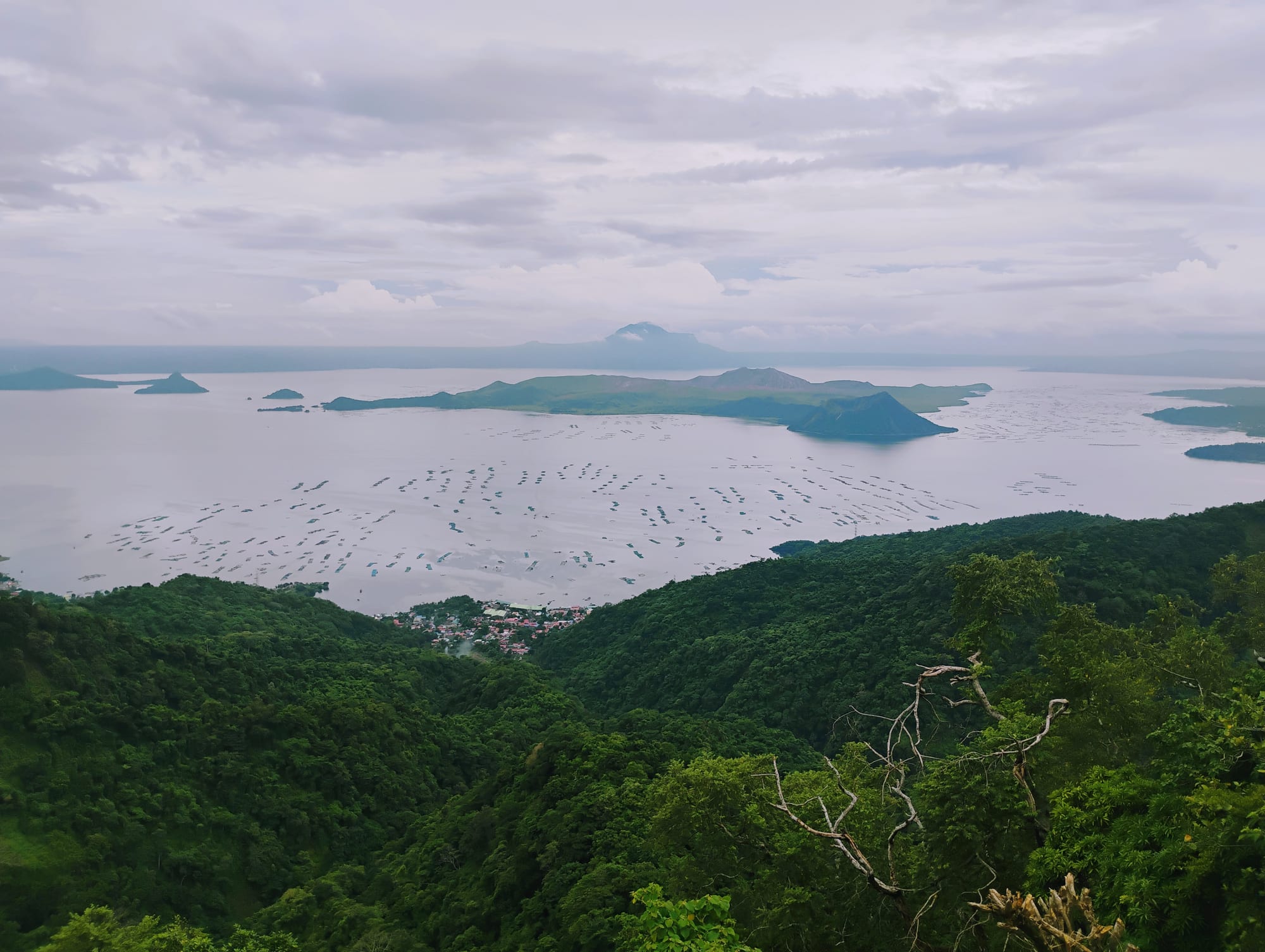
Forested slopes falling away to a wide pale lake with a low volcanic island at its centre and fish pens covering the water

Manila & Central Luzon, Philippines

Tagaytay

Taal Lake and its volcano island seen from the Tagaytay ridge, with fish pens on the water. (Ralff Nestor Nacor / Wikimedia Commons · CC BY-SA 4.0)

A city strung along a ridge in Cavite, about 600 metres above sea level and some 60 kilometres south of Manila, looking down into the caldera that holds Taal Lake and its volcanic island. Cool air, restaurants along the crest and weekend hotels have made it the capital's nearest escape from the heat.

Neighbourhoods

  • The ridge road
    • First-time visitors
    • Views
    • Best for food

    The stretch of the Tagaytay–Nasugbu road along the crest of the caldera rim, where almost every restaurant, café and hotel faces the lake. It is the reason most people come, and at weekends it is one long, slow queue of cars.

    Open in Maps
  • The city centre and Mendez Crossing
    • Markets
    • Local life
    • Close to public transport

    The working part of town away from the view, around the rotunda, the market and the bus stops for Manila and the Batangas towns. Prices drop noticeably a street back from the ridge.

    Open in Maps
  • The Sungay slopes
    • Quiet and residential
    • Views

    The higher ground at the eastern end of the ridge, rising to the town's highest point, with residential subdivisions, a park at the summit and views over both the lake and the lowlands towards Laguna.

    Open in Maps
  • The lakeshore below
    • Lake views
    • Day trips

    A steep road drops from the ridge to the lakeside towns of Talisay and Laurel in Batangas, where fish pens, boat landings and small resorts line the water well below the cool air of the crest.

    Open in Maps

Things to do

The caldera

  • Taal Volcanolandmark

    One of the country's most active volcanoes, an island within a lake within a caldera; it erupted in January 2020, and the volcano island is a permanent danger zone closed to visitors.

    Open in Maps
  • Taal Lakeattraction

    The freshwater lake filling the old caldera, the third-largest lake in the country, whose fish pens supply Manila and whose waters hold the endemic tawilis sardine.

    Open in Maps
  • Mount Sungayviewpoint

    The highest point on the Tagaytay ridge, about 700 metres up, with a long view over the lake on one side and the plains towards Laguna de Bay on the other.

    Open in Maps
  • People's Park in the Skypark

    The unfinished 1980s mansion on the summit of Mount Sungay, begun as a state guest house and left as a shell, now a public viewing park.

    Open in Maps

Parks and viewpoints

  • Tagaytay Picnic Grovepark

    A municipal park on the ridge with lawns, picnic huts, a horse trail and a zip line over the slope towards the lake.

    Open in Maps
  • Sky Ranchattraction

    An amusement park on the ridge, among the most visited places in the town, with fairground rides set along the crest above the lake.

    Open in Maps

Short trips from the ridge

  • Taalattraction

    A heritage town about 25 kilometres south-west, with streets of ancestral houses, a large basilica and a tradition of embroidery and balisong knife making.

    Open in Maps
  • Talisayattraction

    The lakeside town directly below the ridge, the main settlement on the shore of Taal Lake and the base for boats and fish farming.

    Open in Maps
  • Mount Maculottrail

    A steep hill above the far side of Taal Lake in Cuenca, Batangas, whose rocky outcrop looks straight down onto the water and the volcano.

    Open in Maps
  • Mount Batulaotrail

    A grassy peak of about 690 metres west of the town along the Nasugbu road, climbed in a few hours on open ridge trails with views to the coast.

    Open in Maps

Eat and drink

Long-standing places and food districts in Tagaytay. Hours, ratings and directions come from your maps app, always current.

Tagaytay classics

  • Bulalorestaurant

    The dish the town is known for: beef shank and marrow bones simmered for hours into a clear soup with corn and cabbage, eaten in the cool air along the ridge.

    Open in Maps
  • Tawilis and lake fishrestaurant

    Tawilis, a small sardine found only in Taal Lake, is fried crisp and eaten whole with vinegar; tilapia from the lake pens appears grilled or fried on the same menus.

    Open in Maps
  • Kapeng barakocafe

    Strong liberica coffee grown on the Batangas and Cavite uplands, served black and sweet in cafés and roadside stalls along the crest.

    Open in Maps

Markets and roadside stalls

  • Mahogany Marketmarket

    The town's beef market, with stalls at the back serving bulalo and other soups to traders and drivers from early morning.

    Open in Maps
  • Roadside fruit and buko stallsmarket

    Pineapples from the surrounding farms, buko pie made with young coconut, cashews and rice cakes sold from stands along the ridge road.

    Open in Maps

Experience Tagaytay

History

The ridge above Taal Lake was farmland and forest on the edge of Cavite for most of its history, with settlements clustered below rather than on the exposed crest. The caldera below has shaped everything: Taal has erupted dozens of times in recorded history, and the great eruption of 1754 buried and moved several lakeside towns, including Taal itself, which was rebuilt on higher ground to the south-west.

Tagaytay was carved out of neighbouring municipalities and chartered as a city in 1938, shortly after American planners identified the ridge as a healthy, cool site within reach of the capital. During the Second World War its position above the lake made it strategically useful: American paratroopers landed on the ridge in February 1945 as part of the operation to retake Manila from the south.

After the war the town grew slowly as a place for rest houses and retreats, with religious orders building seminaries and convents along the crest for the same reason the Americans chose it — cool air and quiet. The People's Park in the Sky on Mount Sungay was begun in the 1980s as a state guest house for a visiting American president, abandoned unfinished, and later opened to the public. From the 1990s the improvement of the roads from Manila turned Tagaytay into a weekend destination, and hotels, condominiums and restaurants filled the ridge. The 2020 eruption of Taal covered the area in ash, forced evacuations and closed businesses for months, and recovery from it, along with the pressure of weekend traffic, dominates local debate.

Culture & Customs

Tagaytay's culture is Tagalog and Catholic, shaped by its position between the old Cavite towns and the Batangas lake country. It has an unusual concentration of seminaries, convents and retreat houses, drawn by the climate and quiet, and a steady traffic of pilgrims and church groups on retreats gives the ridge a quality quite separate from its restaurants. Holy Week is busy with visitors making the round of churches.

The town's identity is bound to the view and to the weekend. Families from Manila have come up for generations to escape the heat, eat bulalo and look at the volcano, and the rhythm of the week is inverted: quiet from Monday to Thursday, then full. That has created a service economy where much of the workforce commutes from the surrounding towns, and a local pride in the view itself, which is treated as a shared asset to be protected from building.

Caviteño traditions persist in the barangays away from the ridge: town fiestas with processions and brass bands, harvest customs from the pineapple and coffee farms, and the Tagalog manners found across the region — 'po' and 'opo' when speaking to elders, the mano gesture of touching an elder's hand to the forehead, and a strong obligation to feed guests. The volcano is part of local memory rather than a spectacle: most families here have relatives among those evacuated in 2020, and eruptions are spoken of practically.

Daily Life

About 88,000 people live in Tagaytay, a small population for a place that draws weekend crowds from the capital. Most live in the barangays spread along and below the ridge rather than on the crest itself, where land has largely been bought for hotels, restaurants and condominiums.

Tourism is the economy. Hotels, restaurants, cafés, resorts and the souvenir and fruit trade employ most of the workforce, supplemented by people who travel in daily from Mendez, Alfonso, Silang and the Batangas towns. Farming continues on the slopes behind the ridge — pineapples, coffee, vegetables and cut flowers — and fish farming on the lake below supplies Manila's markets with tilapia and bangus.

The week runs to the visitor calendar. Midweek the ridge is calm and local, markets busy in the morning and quiet by afternoon; on Friday the traffic arrives and the restaurants fill until late. Water supply, waste and the pressure of construction on the caldera rim are recurring public issues, along with the state of Taal itself, whose alert level determines whether the lakeside towns below can work at all. Mornings are cold enough for jackets, and the mist that rolls over the ridge by mid-afternoon is part of the town's daily pattern.

Food

Bulalo is the dish that defines the town: beef shanks and marrow bones simmered for hours with corn, cabbage and pechay into a clear, fatty broth, eaten steaming in the cool air. It comes from Batangas cattle country below the ridge, and whole restaurants exist to serve nothing else, along with the stalls at the back of the beef market where it is cheapest and often best.

The lake supplies the other specialities. Tawilis, a freshwater sardine found nowhere else in the world, is fried until crisp and eaten whole with a vinegar and chilli dip; tilapia and milkfish from the pens come grilled, fried or stuffed. Batangas cooking adds lomi, a thick noodle soup with meat and vegetables eaten at roadside stalls, and goto and arroz caldo, rice porridges that suit the climate.

Coffee is a local product: kapeng barako, made from the liberica bean grown on the Cavite and Batangas uplands, is strong, aromatic and traditionally drunk black with sugar. The farms behind the ridge also grow pineapples and coconuts, so buko pie — a pale custard pie of young coconut — is sold from stands along the road and taken back to Manila by the boxful, together with cashew tarts, suman rice rolls and bottled coffee. Sweetcorn boiled or grilled at the roadside and hot taho on cold mornings complete the ridge's informal menu.

Planning tools

Budget

Tagaytay is a weekend resort town and prices reflect it. Hotels and villas on the ridge cost more than anywhere in the region except the Manila business districts, and rates and crowds rise sharply from Friday to Sunday and over long holidays. Eating at a market stall rather than a view restaurant, and staying a street back from the crest, cuts costs substantially.

Daily Budget Midrange
USD 70–160 (hotel with a lake view, restaurant meals, a hired car or Grab rides from Manila)
Daily Budget Shoestring
USD 30–50 (budget inn or transient house off the ridge, market meals, jeepneys and buses)

Come on a weekday if possible: the same room and the same table cost less and the ridge road moves.

Best Time to Visit

December to February is the coolest and clearest, with morning mist in the caldera and the best chance of an unobstructed view of the volcano; it is also the busiest, especially around Christmas and New Year. March to May is warm but still cooler than Manila. From June to November rain and cloud often hide the lake entirely for days.

Suggested Number of Days

Many visitors come up from Manila for a single day. An overnight stay makes more sense for the early-morning views before the cloud builds, and two or three days allows the lakeshore and the Batangas towns below the ridge.

First Visit
1 day
With Surroundings
2–3 days

Transportation

Buses from Manila terminals run to Tagaytay in around two to three hours depending on traffic, and jeepneys and vans work the ridge road and the routes down to the lake towns. Tricycles cover short distances in town. Many visitors drive or use ride-hailing from the capital, and the single ridge road becomes very slow at weekends.

Agree tricycle fares in advance, and allow much longer than the map suggests for any journey along the ridge on a Saturday or Sunday.

Airport & Station Connections

The town lies about 60 kilometres south of Manila, reached by the expressway and provincial roads in roughly two hours when traffic is light and considerably longer at peak times. Buses leave from several Manila terminals, and there are connections from the Batangas towns and from Nasugbu on the coast. The nearest airport is Manila's.

Walkability

Limited. The town is strung out over several kilometres of ridge road with narrow or missing pavements and constant traffic, so walking between restaurants and viewpoints is unpleasant even where the distance is short. Parks, market areas and individual complexes are fine on foot, and the lakeshore is reached only by vehicle down a steep road.

Safety

Tagaytay is a low-crime town and its main hazards are the volcano and the road. Taal is closely monitored, alert levels change, and the volcano island is a permanent danger zone; ashfall and evacuation orders affect the lakeside towns rather than the ridge. Traffic on the winding ridge road and the steep descent to the lake is the everyday risk, and the nights are cool enough to surprise visitors from the lowlands.

Follow PHIVOLCS alert levels for Taal before going anywhere near the lake, and take care on the steep lakeside roads in rain. Monitor PAGASA for storms, keep away from volcanic danger zones, take dengue precautions year-round, and do not travel to the Sulu provinces or the Zamboanga peninsula. Check current official travel advice before travelling.

Climate

Cooler than the lowlands because of the altitude, with daytime temperatures generally around 22 to 28°C and nights that can fall into the high teens. Cloud and mist form along the ridge on many afternoons, and the wet season from about June to November brings heavy rain and long spells when the lake is invisible.

Summer
March–May is warm and often hazy, around 24–30°C, several degrees below Manila
Winter
December–February is cool and dry, around 20–26°C by day with nights in the high teens and morning mist

Local Customs

This is a Tagalog-speaking Catholic town where English is widely understood. Weekend visitors are the economy, and service is used to outsiders, but ordinary courtesies matter: greeting before asking, addressing older people respectfully, and dressing modestly in churches. Tipping is modest and a service charge is often included. Many restaurants fill with large family groups, and tables on the ridge are shared cheerfully.

Bring a jacket for the evenings, ask before photographing people at work in the market, and expect restaurants to be noisy family places rather than quiet ones.

Common Payment Methods

The currency is the Philippine peso. Cards work in hotels, malls and larger restaurants along the ridge, but market stalls, tricycles, jeepneys and roadside sellers take cash only. Cash machines are in the town centre and in the malls, with low withdrawal limits and fees, and are scarcer once the road drops towards the lake.