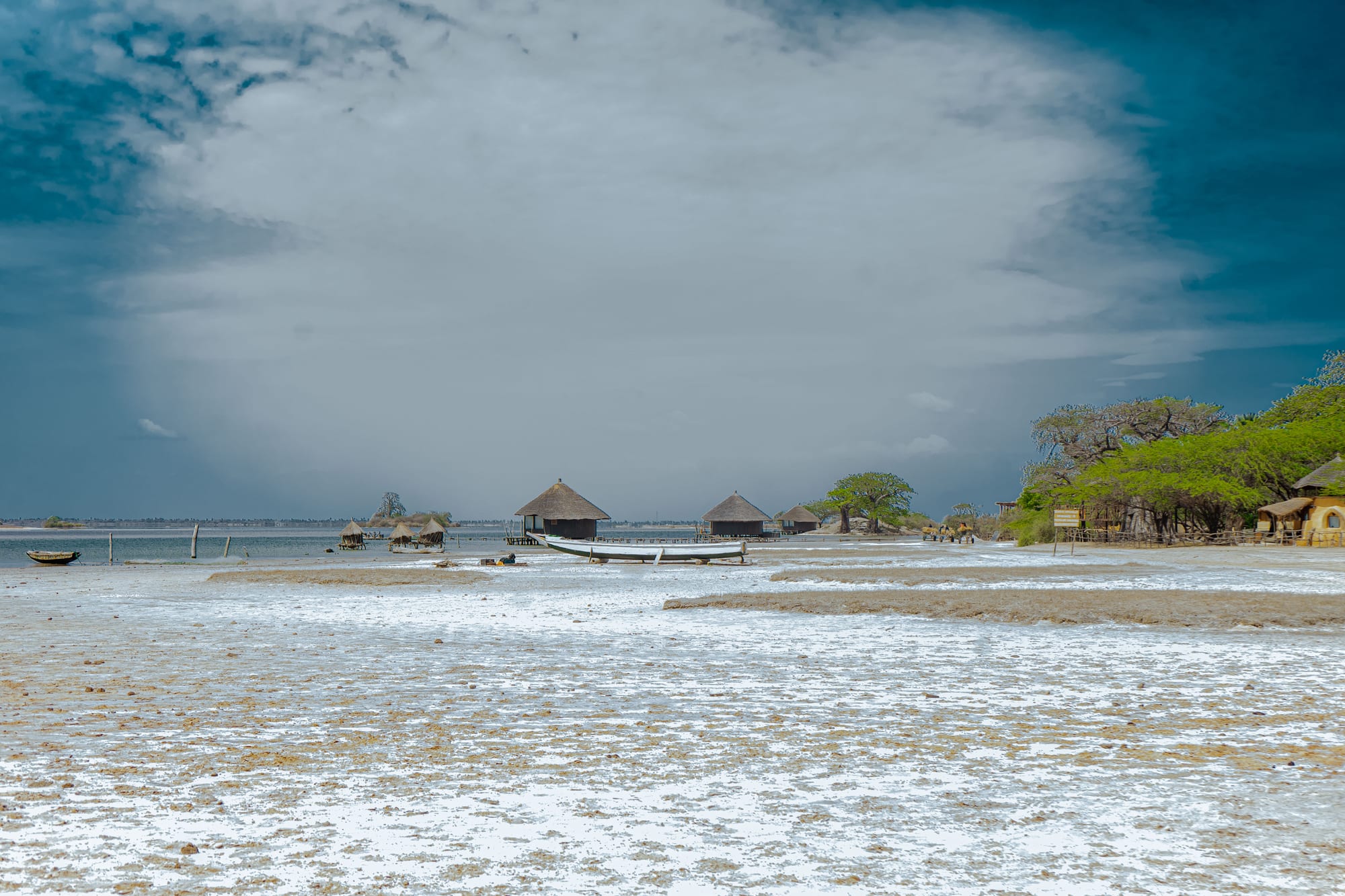
A wide salt-crusted shore with a beached wooden boat and thatched round huts standing over shallow lagoon water under heavy cloud

The Sine-Saloum Delta & the Centre, Senegal

Palmarin

Salt-crusted flats and thatched huts on the lagoon at Palmarin, on the northern edge of the Saloum delta. (Thiamlanaa / Wikimedia Commons · CC BY-SA 4.0)

A line of Serer fishing villages on a narrow strip of land between the Atlantic and the lagoons at the northern edge of the Saloum delta in central Senegal. Salt pans, tidal creeks, baobabs and palms surround settlements that live from fishing, salt and, increasingly, from small lodges built along the water.

Neighbourhoods

  • Ngallou and the road in
    • First-time visitors
    • Local life
    • Transport connections

    The northern end of Palmarin, where the road from Fimela and Joal arrives and where shops, the transport stop and everyday village life are concentrated. It is the most built-up part of the commune and the easiest place to arrive without a booking.

    Open in Maps
  • The lagoon shore and the lodges
    • Quiet and residential
    • Birdwatching
    • Sunsets

    Small lodges and campements stand in ones and twos along the creeks and salt flats on the inland side of the strip, often built in thatch on stilts over the water. They are spread out, with long sandy tracks between them and little else around.

    Open in Maps
  • Diakhanor, Facao and the southern villages
    • Beaches
    • Fishing village
    • Walks

    The villages strung out towards the southern tip, between the ocean beach and the salt pans. Pirogues are drawn up on the sand, drying racks and salt heaps line the tracks, and the land narrows towards the point at the mouth of the Saloum.

    Open in Maps

Things to do

The shore and the lagoons

  • Palmarin beachbeach

    A long, almost empty ocean beach running the length of the commune, backed by dunes and used by the fishing pirogues that launch straight off the sand.

    Open in Maps
  • Palmarin community nature reservepark

    A community nature reserve of lagoons, mudflats and salt steppe behind the villages, one of Senegal's listed protected areas, with large numbers of waterbirds on its shallow water.

    Open in Maps
  • The salt flatsviewpoint

    Shallow pans between the villages and the lagoon where sea water is left to evaporate, worked by hand and covered in white crust for much of the dry season.

    Open in Maps

The delta

  • Saloum Delta National Parkpark

    The protected heart of the delta south of Palmarin, a maze of mangrove channels, islands, mudflats and woodland with pelicans, flamingos and terns.

    Open in Maps
  • Saloum Delta World Heritage Siteattraction

    Listed by UNESCO in 2011 for hundreds of shell mounds and burial tumuli built up over centuries by the delta's shellfish-gathering communities.

    Open in Maps
  • Pointe de Sangomarviewpoint

    The sand spit running south from Palmarin Diakhanor towards the mouth of the Saloum, broken through by a tidal surge in 1987 that created the island of Sangomar, and a place of deep significance in Serer belief.

    Open in Maps

Short trips from the villages

  • Joal-Fadiouthattraction

    A fishing town up the coast, joined by a wooden bridge to Fadiouth, an island of clam shells; a further shell island holds the Christian and Muslim cemeteries, and granaries stand on stilts in the water.

    Open in Maps
  • Fimelaattraction

    The seat of the arrondissement, a village of a couple of thousand people inland from Palmarin, on the road towards the delta's boat landings.

    Open in Maps

Seasonal events

  • Migratory bird seasonNovember to March

    Waders, terns, flamingos and pelicans concentrate on the lagoons and salt flats, joined by European migrants wintering in the delta.

  • Salt harvestthe dry season, roughly February to June

    Evaporation pans are worked as the heat builds, and salt is raked, heaped and carried away for sale inland.

Eat and drink

Long-standing places and food districts in Palmarin. Hours, ratings and directions come from your maps app, always current.

Palmarin classics

  • Grilled fish from the beachrestaurant

    Whatever the pirogues land — capitaine, mullet, sole, barracuda, shrimp — grilled over wood and served with rice or chips at the lodges and in small village eating houses.

    Open in Maps
  • Mangrove oysters and shellfishmarket

    Oysters, cockles and arches gathered in the creeks by women's groups, sold fresh, dried or smoked, and cooked into sauces with rice.

    Open in Maps

Village food

  • Village stalls and the weekly marketmarket

    Millet, rice, vegetables, dried fish, bread and roasted groundnuts change hands in the villages; the bigger weekly markets are at Fimela and Joal.

    Open in Maps
  • Palm wine and bissap standsneighborhood

    Palm wine is tapped from the rônier and oil palms behind the villages, and cold hibiscus and baobab juices are sold in sachets wherever there is a shop.

    Open in Maps

Experience Palmarin

History

Palmarin's story belongs to the Serer, who settled the strip between the ocean and the delta long before any European reached the coast and who left their record in the shell mounds heaped along the creeks. The land here is thin, salty and easily flooded, so villages were placed on low rises, and life was organised around fishing, salt and small fields rather than the grain farming of the interior. The commune's villages — Palmarin Ngallou, Palmarin Ngounoumane, Palmarin Diakhanor and Palmarin Ngueth among them, with Facao giving the place its other name — grew up as separate settlements and are still known by their own names.

Politically the area lay at the edge of the Serer kingdom of Sine, whose rulers held the country north and east of the delta until the French took control late in the nineteenth century. Palmarin remained remote: reached by track and tide rather than road, it stayed a place of fishermen and salt workers through the colonial period and the first decades after independence in 1960.

Two changes have shaped the modern commune. The sea has advanced, taking ground from the villages, breaking through the spit at the mouth of the Saloum and pushing salt further into what farmland there was, and the response has included mangrove replanting and a community-run nature reserve. The other change is tourism: from the 1990s onward, small lodges appeared along the lagoon, offering an alternative to the resorts of the Petite Côte, and they now provide much of the wage work in a commune that otherwise lives from the water.

Culture & Customs

Palmarin is strongly Serer, and Serer identity here is layered rather than divided: households may be Muslim or Catholic, and traditional beliefs about the land, the sea and the ancestors continue alongside both. The point of Sangomar at the delta's mouth holds a particular place in that tradition as a dwelling of the spirits of the dead, and the coast is full of sites treated with care rather than curiosity.

Kinship and age-groups organise village life, with work parties for fishing, salt, repairs and replanting drawn along those lines, and women's associations run the shellfish harvest and much of the small trade. Ceremonies mark naming days, weddings and funerals, with drumming and the wrestling that the Serer take more seriously than almost anyone in Senegal; bouts after the harvest draw people from across the commune.

Visitors are a recent presence and a normal one, and the etiquette expected is the same as elsewhere in rural Senegal: greet before asking, accept tea, ask before photographing, and take a village guide rather than wandering into the reserve or onto sacred ground. Many people speak Serer at home, Wolof in the market and French with officials, and the older generation remembers when the road ended well short of the villages.

Daily Life

A few thousand people live in the commune, spread between its villages, and the population is young, with many of the men and women of working age absent in Dakar, Mbour or abroad. Ngallou is the busiest settlement, with shops, the transport stop and most services; the others are quieter lines of compounds between the beach and the salt pans.

Work follows the water. Men fish from pirogues launched off the ocean beach or in the creeks, and the catch is sold fresh, dried or smoked; women gather oysters and cockles in the mangroves and run the drying racks. Salt is the other old industry, raked from evaporation pans in the dry season and carried inland. Small fields of millet and vegetables, a few cattle and goats, and wages from the lodges fill out household incomes.

The rhythm is tidal and seasonal: early starts, a long pause in the afternoon heat, and evenings spent outside. The commune's pressing problems are physical — erosion of the shore, saltier soil and wells, mangrove cut for fuel, and falling fish catches — alongside the lack of paid work that keeps young people leaving for the cities.

Food

Palmarin eats what the shore provides. Fish grilled over wood is the standard meal, from capitaine and mullet to sole, barracuda and shrimp, served with rice, onions and lemon. Oysters gathered from mangrove roots are grilled or dried; cockles and arches are boiled and dried in quantity and cooked into sauces that reach well beyond the commune. Dried and smoked seafood is one of the delta's main exports to the inland markets.

The Senegalese repertoire is cooked here with local ingredients: ceebu jën, fish and vegetables over broken rice cooked in tomato; yassa with lemon and heaps of onions; mafé, a groundnut stew; and soupou kandja, an okra and palm-oil sauce. Millet appears as thiéré, steamed couscous, and as lakh, sweet porridge with curdled milk, and among Serer Christian families ngalakh, a millet, groundnut and baobab mixture, is made for Christian festivals and shared with Muslim neighbours.

Drinks are cold and local: bissap from hibiscus, bouye from baobab fruit, ginger and tamarind juices sold in sachets, and ataya tea in three sweet rounds. Palm wine tapped from the trees behind the villages is drunk locally, and the salt harvested on the doorstep seasons nearly everything cooked in the commune.

Planning tools

Budget

There is little to spend money on beyond bed, board and boats. Simple campements are inexpensive, while the eco-lodges on the lagoon charge considerably more and usually include meals, which matters in a place with few independent restaurants. Boat trips and a vehicle to reach the villages are the other costs.

Daily Budget Midrange
USD 80–190 (lagoon lodge with meals, private pirogue excursions, a car and driver)
Daily Budget Shoestring
USD 25–50 (simple campement, village eating houses, shared taxis, a shared pirogue)

Bring enough cash for the whole stay, and agree the price of a boat trip or a guided walk in the reserve before setting out.

Best Time to Visit

November to April is the best season: dry, breezy on the coast, with the lagoons full of birds and the salt pans working. May and June are hot. The rains from July to October bring humidity and mosquitoes, green countryside, and quieter, sometimes closed, lodges.

Suggested Number of Days

Two days is enough to take in the shore, the lagoons and the villages at an unhurried pace. Three or four suit anyone combining Palmarin with the wider delta or the coast to the north. Tides and the heat shape the day more than anything else.

First Visit
2 days
With Surroundings
3–4 days

Transportation

Palmarin has no public transport of its own. Sept-place taxis and minibuses run to Ngallou from Joal and Fimela, and from there horse carts, motorcycle taxis and walking cover the sandy tracks between villages. Lodges send vehicles or boats for guests, and a hired car with driver is the practical way to move around.

Sand tracks between the villages are soft and are best tackled with a suitable vehicle or on foot rather than in an ordinary saloon car.

Airport & Station Connections

The commune is reached by road from Joal-Fadiouth along the coast, or inland through Fimela from the Dakar to Kaolack road, roughly three to four hours from Dakar in all. There is no airport or ferry; most visitors come by hired car, by sept-place taxi with a final transfer, or in a lodge vehicle.

Walkability

Walking is the natural way to see Palmarin, but the villages are strung out over several kilometres and the distances add up, particularly between lodges on the lagoon and the shops in Ngallou. Tracks are sandy and unlit at night, the beach gives the easiest walking line, and the heat confines most walking to early morning and late afternoon.

Safety

The commune is quiet and crime is rare. The practical hazards are natural: strong currents and no lifeguards on the ocean beach, tidal creeks and soft mud around the lagoons, sun and dehydration, and malaria year-round. Wild animals live in the bush behind the villages and are best kept at a distance, and walking unlit tracks at night calls for a torch.

Don't walk the Corniche or empty beaches after dark or carry valuables, be firm with touts, take malaria precautions, and check current advice for the far east near Mali and rural Casamance. Take local advice before swimming, and carry a torch and water. Check current official travel advice before travelling.

Climate

Tropical savanna, tempered by the Atlantic: days on the spit are usually breezier and a little cooler than inland at Kaolack. A long dry season runs from November to June and a hot, humid rainy season from roughly July to October, when most of the year's rain falls in short storms.

Summer
hot and humid, around 26–34°C, with heavy downpours between July and October
Winter
dry and pleasant, around 18–32°C, with sea breezes and cool nights

Local Customs

These are Serer villages, with Muslim and Catholic families and traditional Serer belief present alongside both; the delta and the point at Sangomar carry religious meaning, and sacred sites should be treated accordingly. Serer and Wolof are spoken, with French in schools and offices. Greetings are unhurried and tea is offered freely.

Ask before photographing people, houses or fishing boats, dress modestly away from the beach, and ask a local guide before entering the reserve or sacred ground.

Common Payment Methods

The currency is the West African CFA franc (XOF). This is a cash place: some lodges take cards or ask for a transfer in advance, but boatmen, guides, carts and village shops want notes, and the nearest dependable cash machines are at Joal-Fadiouth or further afield at Mbour and Fatick.