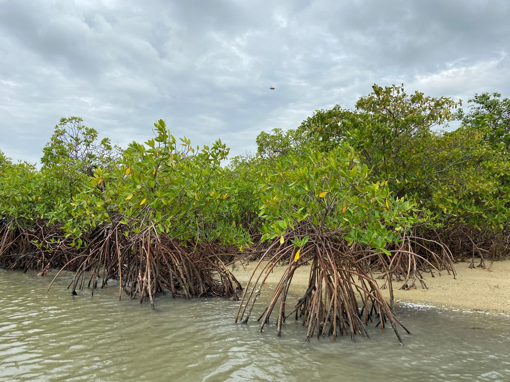
Mangrove trees standing on tangled stilt roots along a pale sandbank at the edge of green-grey tidal water

The Sine-Saloum Delta & the Centre, Senegal

Toubacouta

Mangroves on the tidal channels of the Saloum delta near Missirah, a short distance from Toubacouta. (Fatimetouu / Wikimedia Commons · CC BY-SA 4.0)

A village in central Senegal on the southern edge of the Saloum delta, close to the border with The Gambia. It stands where dry savanna meets the mangrove channels of the Bandiala, and it has become the main base on that side of the delta for pirogue trips, birdwatching and visits to the shell mounds and forest reserves nearby.

Neighbourhoods

  • The village and the main road
    • First-time visitors
    • Local life
    • Markets

    Toubacouta proper is a single spread of compounds, shops and a mosque along the road that runs south towards the Gambian border. Transport stops here, the weekly market fills the open ground, and most services in the commune are within a few hundred metres.

    Open in Maps
  • The waterside and the lodges
    • Boat trips
    • Birdwatching
    • Quiet and residential

    Below the village the ground drops to a creek off the Bandiala channel, where pirogues are moored and the campements and eco-lodges stand among trees along the water. This is where excursions start, and where the delta's birdlife is closest at dawn and dusk.

    Open in Maps
  • Missirah
    • Fishing village
    • Boat trips
    • Quiet and residential

    A fishing village a short drive north-west of Toubacouta, on the Bandiala where the channel widens. Its wharf is a common departure point for boats, and the forest of the reserve comes almost to the edge of the houses.

    Open in Maps

Things to do

The delta and its wildlife

  • Saloum Delta National Parkpark

    The protected core of the delta, created in 1976 and covering some 760 square kilometres of mangrove channels, tidal flats, islands, savanna woodland and a long stretch of coast.

    Open in Maps
  • Saloum Delta World Heritage Siteattraction

    The delta was inscribed by UNESCO in 2011 for its shell mounds, burial tumuli and the fishing and shellfish-gathering way of life that produced them.

    Open in Maps

Short trips from the village

  • Fathala Reserveattraction

    A wildlife reserve in the Fathala classified forest, the land portion of the national park, between Toubacouta and the Gambian border, where indigenous animals live alongside species brought from elsewhere in Africa.

    Open in Maps
  • Karangattraction

    The Senegalese border post on the road to The Gambia, about 20 km south, a busy crossing of lorries, money changers and market stalls.

    Open in Maps
  • Sokoneattraction

    The nearest sizeable town, north of Toubacouta on the main road, with a market and services for the surrounding villages.

    Open in Maps
  • Foundiougneattraction

    An old river port on the Saloum about 40 km to the north, long reached by ferry and, since the Nelson Mandela Bridge opened in 2022, by road, and another departure point for boats into the channels.

    Open in Maps

Seasonal events

  • Bird migration seasonNovember to March

    Palearctic waders and terns winter on the sandbanks and mudflats alongside resident pelicans, herons and flamingos, and boat trips are at their best in the dry, calm months.

  • Groundnut harvestOctober to December

    The fields inland fill with piles of drying groundnuts, horse carts and village weighing stations, the busiest point of the farming year in this part of Senegal.

Eat and drink

Long-standing places and food districts in Toubacouta. Hours, ratings and directions come from your maps app, always current.

Delta food

  • Grilled mangrove oystersmarket

    Oysters that grow on mangrove roots are collected by women in the channels, then grilled over embers or dried and smoked; they are sold in the village and served at the lodges.

    Open in Maps
  • Fish from the channelsrestaurant

    Barracuda, captain fish, mullet and shrimp from the delta are grilled whole or cooked into ceebu jën and yassa at the campements and in small eating houses along the road.

    Open in Maps

Markets and stalls

  • Toubacouta village marketmarket

    A small market for vegetables, millet, dried fish and household goods, busiest on its weekly market day, when traders come in from the surrounding villages.

    Open in Maps
  • Missirah landingneighborhood

    The fishing wharf where the day's catch is landed, sorted and dried, and where shellfish gathered in the mangroves is brought ashore.

    Open in Maps

Experience Toubacouta

History

The delta around Toubacouta has been inhabited for a very long time, and the proof is under foot: mounds of discarded shells, some of them many metres high and used as burial sites, were built up over centuries by people harvesting shellfish from the mangroves. The delta holds more than two hundred such mounds, and excavations at some of the burial grounds among them have opened a window on how long people have lived here; it was these mounds and tumuli that led UNESCO to list the Saloum delta in 2011.

Historically this southern edge of the delta lay on the frontier between the Serer kingdom of Saloum and the Mandinka-ruled lands along the Gambia river, and the mixed population of the commune still reflects that meeting. Toubacouta itself is described as a Mandinka village. In the nineteenth century the region was crossed by the jihad of Maba Diakhou Ba and then brought under French control, and the colonial border that followed the Gambia river turned what had been an ordinary stretch of country into an international frontier a short distance to the south.

Under French and then independent rule, the area lived from farming, fishing and salt, and Toubacouta was a modest village on a road to the border. Two later decisions shaped it: the creation of the Saloum Delta National Park in 1976, which protected the channels and forest around it, and the arrival of tourism from the 1980s onwards, as campements and lodges opened on the waterside and the village became a base for visiting the delta.

Culture & Customs

Toubacouta sits at a cultural crossing point. Serer, Mandinka, Fula and Wolof families share the commune, most of them Muslim, with a Christian minority among Serer households, and several languages are heard in a single street. Wolof is the common tongue and French the language of school and administration, while Mandinka links the area to The Gambia just to the south, and cross-border family ties are ordinary here.

Life in the delta villages is organised around the water and divided by gender in long-standing ways: men fish from pirogues and cut poles in the mangroves, while women gather oysters, cockles and arches, process and smoke them, and increasingly run the associations that manage the shellfish beds and replant mangrove. Those replanting days, often organised village by village, have become a local institution and a point of pride.

Music and celebration follow the national pattern — sabar drumming at naming ceremonies and weddings, kora players in Mandinka households, wrestling bouts after the harvest — and visitors staying at the lodges are often invited to village events. Manners are those of rural Senegal: long greetings, an offer of tea, and a preference for asking permission rather than assuming it.

Daily Life

A few thousand people live in Toubacouta itself, with more in the villages of the commune scattered between the road and the water. It is a rural place with a school, a health post, shops along the road and a market that comes to life once a week; the nearest town of any size is Sokone, and the department town is Foundiougne to the north.

Three activities carry the local economy. Farming fills the rainy season and the months after it: groundnuts above all, with millet, sorghum and vegetable plots, and cattle and goats kept by most households. Fishing and shellfish gathering go on all year in the channels, supplying dried and smoked seafood that is traded far inland. Tourism is the third, employing guides, boatmen, cooks and drivers at the lodges — work that is seasonal and concentrated in the dry months.

Days begin early, quieten through the hot afternoon and end with tea and talk outside the compounds. The problems people name are the ones common to the delta: salt pushing into farmland, the loss of mangrove cut for fuel and building, falling catches in the channels, and the shortage of work that sends young people to Kaolack, Dakar or The Gambia.

Food

The delta's own food is shellfish. Mangrove oysters, prised from the roots by women working at low tide, are grilled over wood, dried in the sun or simmered into a sauce with rice; cockles and arches are boiled, dried and sold by the bowl. Fish from the channels — mullet, captain fish, barracuda, catfish and shrimp — is grilled whole, or cooked as ceebu jën, fish and vegetables over broken rice, and yassa, with lemon and a mass of softened onions.

Inland the cooking is that of the peanut basin. Mafé, meat or fish in a thick groundnut sauce, appears constantly, and millet is eaten as thiéré, steamed couscous under a sauce, or as lakh, a sweet porridge with curdled milk. Rice is the staple of the main midday meal, eaten from a shared bowl, and roasted groundnuts are sold in paper cones wherever transport stops.

Drinks are simple and cold: bissap made from dried hibiscus, bouye from baobab fruit, ginger juice, and ataya, strong green tea boiled with sugar and poured in three rounds through the afternoon. Palm wine is tapped in some villages towards the Gambian border, and the lodges stock beer and soft drinks that are otherwise hard to find in the commune.

Planning tools

Budget

Daily costs in the village are low, but the delta is what people come for and boats are the main expense. Campements and eco-lodges around Toubacouta often quote half board, which suits a place with few restaurants, and a pirogue excursion with a boatman is charged by the trip rather than the person.

Daily Budget Midrange
USD 80–190 (delta lodge with meals, private pirogue excursions, a car and driver)
Daily Budget Shoestring
USD 25–50 (simple campement, local food, shared taxis, a shared pirogue)

Agree the route, the length and the price of a boat trip before boarding, and ask whether fuel and a guide are included.

Best Time to Visit

November to April is the season: dry, less humid, with calm channels and the largest numbers of migrant birds. March to June is hot inland. The rains from July to October bring mosquitoes to the mangroves and green countryside, and many lodges are quiet or closed for part of that period.

Suggested Number of Days

Two days allow a full morning on the water and time to see the village. Three or four suit visitors who want more than one boat trip, a look at the wider delta or a crossing into The Gambia. Tides, not opening times, decide when boats can go.

First Visit
2 days
With Surroundings
3–4 days

Transportation

There is no public transport within the commune. Sept-place taxis and minibuses on the Kaolack to Banjul road stop in the village, and from there everything is walking, a motorcycle taxi, a horse cart or a boat. Lodges arrange pirogues and vehicles, and a hired car with driver is the usual way to reach the reserves and other villages.

Ask for life jackets before a pirogue trip, and check the tide with the boatman, as some channels are impassable at low water.

Airport & Station Connections

Toubacouta lies on the main road between Kaolack and the Gambian border at Karang, roughly 70 km from Kaolack and about four to five hours from Dakar by road. Most visitors arrive by hired car or sept-place taxi, or are collected by their lodge; the border crossing to The Gambia is about 20 km further south.

Walkability

The village is small, flat and walkable end to end in a quarter of an hour, and the path down to the water is short. Sand tracks rather than pavements link the compounds and the lodges, and walking is comfortable early and late but hard in the middle of the day. Anything beyond the village means a vehicle or a boat.

Safety

Toubacouta is calm, and the main risks are practical ones. Pirogues can be overloaded and life jackets are not always carried; the channels have strong tidal currents. Mosquitoes are thick in the mangroves, especially in the rainy season, and malaria is present year-round. The main road carries heavy lorry traffic to and from the Gambian border.

Don't walk the Corniche or empty beaches after dark or carry valuables, be firm with touts, take malaria precautions, and check current advice for the far east near Mali and rural Casamance. Use a life jacket on the water and avoid boat trips in poor weather. Check current official travel advice before travelling.

Climate

Tropical savanna, softened a little by the sea and the delta. A long dry season runs from November to June, with harmattan haze inland, and a hot, humid rainy season follows from roughly July to October, when most of the year's rain falls in heavy storms.

Summer
hot and humid, around 27–35°C, with downpours and thunderstorms from July to October
Winter
dry and warm, around 18–33°C, with cooler nights and a breeze off the delta

Local Customs

The commune is mostly Muslim, with Serer, Mandinka, Fula and Wolof families living side by side and several languages in daily use alongside Wolof and French. Greetings come before anything else, food is shared from a common bowl, and ataya tea is offered in three rounds. Modest dress is expected away from the lodges.

Ask before photographing people, their boats or their catch, agree a fee with a guide in advance, and cover shoulders and knees in the village.

Common Payment Methods

The currency is the West African CFA franc (XOF). Cash is essential: a few lodges take cards, but boatmen, guides, drivers and the market do not, and the nearest reliable cash machines are in Sokone or Kaolack. Gambian dalasi and euros are sometimes accepted near the border at poor rates.