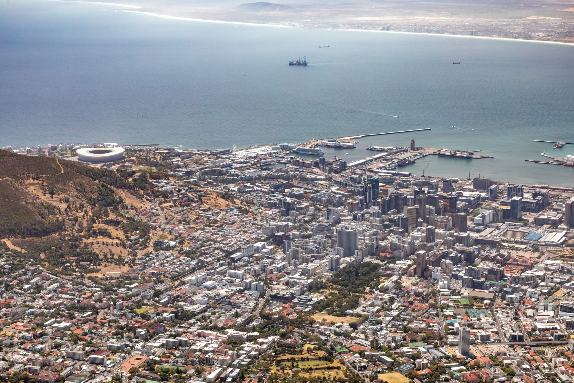
A dense city of low white buildings and glass towers filling a bowl of land between a wooded ridge and a wide blue bay

Cape Town & the Western Cape, South Africa

Cape Town

The City Bowl, the harbour and Table Bay seen from the top of Table Mountain. (Dietmar Rabich / Wikimedia Commons · CC BY-SA 4.0)

South Africa's oldest city and its legislative capital, wrapped around Table Bay beneath the sandstone wall of Table Mountain. Founded as a Dutch East India Company supply station in 1652, it grew on shipping, slavery and colonial government, and is now a port, parliamentary seat and tourism centre where great wealth and severe inequality sit side by side.

Neighbourhoods

  • City Bowl
    • First-time visitors
    • Historic district
    • Close to public transport

    The old centre, held in a bowl of land between Table Mountain, Devil's Peak, Lion's Head and the bay. Parliament, the Company's Garden, the Iziko museums and the Castle of Good Hope stand within a few blocks, and Long Street and Bree Street carry most of the centre's restaurants and bars.

    Open in Maps
  • Bo-Kaap
    • Historic district
    • Best for food
    • Photography

    A steep quarter on the lower slopes of Signal Hill, historically the heart of Cape Malay life and home to some of the country's oldest mosques. Its flat-fronted 18th- and 19th-century houses were painted in bright colours from the late 20th century. It is a lived-in residential area, and residents ask that homes and people are not photographed without permission.

    Open in Maps
  • V&A Waterfront
    • First-time visitors
    • Families
    • Shopping

    A working harbour redeveloped from the late 1980s into a district of shops, restaurants, museums and hotels around the old basins. The Robben Island ferries, the Two Oceans Aquarium and Zeitz MOCAA are all here, and tugs and fishing boats still use the quays.

    Open in Maps
  • Sea Point and Green Point
    • Walks by the sea
    • Best for food
    • Quiet and residential

    Flats and guesthouses along the Atlantic shore north-west of the centre, linked by a long paved promenade above the rocks. Main Road runs behind it with delis, bakeries and restaurants, and Cape Town Stadium and the urban park beside it lie at the Green Point end.

    Open in Maps
  • Camps Bay and Clifton
    • Beaches
    • Sunsets
    • Nightlife

    The Atlantic seaboard below the Twelve Apostles ridge, reached over Kloof Nek from the centre. White sand, cold water and a strip of restaurants facing the sea make it the city's holiday face, and prices here are the highest in Cape Town.

    Open in Maps
  • Woodstock
    • Art and design
    • Best for food
    • Street art

    An old working-class suburb east of the centre, mixed in character, with converted warehouses holding galleries, design studios, breweries and market halls alongside terraced houses and light industry.

    Open in Maps
  • Southern Suburbs
    • Quiet and residential
    • Gardens and wine
    • Families

    The leafy belt on the eastern side of the mountain, running through Observatory, Rondebosch, Newlands and Constantia. Kirstenbosch, the University of Cape Town, the old Constantia wine estates and forest walks up the mountain slopes are all along this side.

    Open in Maps

Things to do

Famous landmarks

  • Table Mountainlandmark

    The flat-topped sandstone massif that fills the skyline above the centre, reached on foot up Platteklip Gorge or by cableway, and named one of the New7Wonders of Nature in 2011.

    Open in Maps
  • Table Mountain Aerial Cablewayattraction

    The cable car that has run to the summit since its opening in October 1929, rebuilt in 1997 with larger cars whose floors turn through a full circle on the way up.

    Open in Maps
  • Castle of Good Hopelandmark

    A five-pointed stone fort built by the Dutch East India Company between 1666 and 1679, the oldest surviving colonial building in South Africa, with military and Iziko museum collections inside.

    Open in Maps
  • Lion's Headviewpoint

    A conical peak between Table Mountain and the sea, climbed by a spiralling path that is busy at sunrise and on full-moon nights.

    Open in Maps
  • Signal Hillviewpoint

    The low ridge above Bo-Kaap where the Noon Gun is fired by the South African Navy, with a road to a viewpoint over the city and bay.

    Open in Maps
  • Cape Town Stadiumattraction

    The bowl-shaped stadium at Green Point built for the 2010 FIFA World Cup, now used for football, rugby and concerts.

    Open in Maps

Museums and memory

  • Robben Islandmuseum

    The island in Table Bay used as a prison, leper colony and military base, where Nelson Mandela was held for 18 years; a UNESCO World Heritage Site since 1999, visited by ferry from the V&A Waterfront.

    Open in Maps
  • District Six Museummuseum

    A memorial museum in an old Methodist church recording the inner-city district that was declared white in 1966 and whose residents were removed to the Cape Flats from 1968, their streets then demolished.

    Open in Maps
  • Zeitz Museum of Contemporary Art Africamuseum

    A museum of contemporary art from Africa and its diaspora, opened in 2017 inside a converted grain silo on the V&A Waterfront.

    Open in Maps
  • Iziko South African Museummuseum

    The country's oldest museum, founded in 1825, on the edge of the Company's Garden, with natural history, San rock art and a planetarium.

    Open in Maps
  • Iziko South African National Gallerymuseum

    The national art collection in the Company's Garden, strongest in South African painting, photography and contemporary work.

    Open in Maps
  • Two Oceans Aquariumattraction

    An aquarium on the Waterfront devoted to the cold Atlantic and warm Indian Ocean waters around southern Africa, with a kelp forest tank and an ocean exhibit.

    Open in Maps

Gardens, parks and the waterfront

  • Kirstenbosch National Botanical Gardenpark

    A garden of South African plants founded in 1913 on the mountain's eastern slopes about 13 km from the centre, growing the fynbos of the Cape Floristic Region, whose protected areas were inscribed as a UNESCO World Heritage Site in 2004.

    Open in Maps
  • Company's Gardenpark

    The vegetable garden laid out for passing ships in 1652, now a public park of oaks and roses running up from the centre past Parliament and the museums.

    Open in Maps
  • Victoria & Alfred Waterfrontattraction

    The Victorian harbour basins, built between 1860 and 1920 and rebuilt from the late 1980s as a quayside district of shops, restaurants and museums, with the Robben Island ferry terminal and views back to the mountain.

    Open in Maps
  • Table Mountain National Parkpark

    The park that protects the mountain chain running the length of the Cape Peninsula, from the city's slopes south to Cape Point; it forms part of the Cape Floral Region World Heritage Site and is crossed by walking paths.

    Open in Maps
  • Sea Point Promenadetrail

    A wide paved walk of several kilometres above the Atlantic rocks, busy with walkers, runners and families from dawn until dark.

    Open in Maps

Beaches near the city

  • Camps Bay Beachbeach

    A wide white beach under the Twelve Apostles ridge, backed by a line of restaurants; the water is cold and the wind can be strong.

    Open in Maps
  • Clifton beachesbeach

    Four small coves separated by granite boulders below the Victoria Road, sheltered from the south-easterly wind.

    Open in Maps

Short trips from the city

  • Cape Pointviewpoint

    The headland at the southern tip of the peninsula, about 65 km by road from the centre, with an old lighthouse on the high point and the Flying Dutchman funicular running up to it.

    Open in Maps
  • Cape of Good Hopelandmark

    The rocky cape beside Cape Point, long a landmark for ships rounding Africa, with walking trails through coastal fynbos.

    Open in Maps
  • Boulders Beachbeach

    A sheltered beach of granite boulders at Simon's Town, about 40 km away, where a colony of African penguins settled in the 1980s and is watched from boardwalks.

    Open in Maps
  • Muizenbergbeach

    A long, warm-water surf beach on False Bay about 25 km by road from the centre, with its row of brightly painted beach huts.

    Open in Maps
  • Chapman's Peak Driveviewpoint

    A toll road cut into the cliffs between Hout Bay and Noordhoek, with a long series of bends above the Atlantic.

    Open in Maps
  • Kalk Bayneighborhood

    A fishing harbour on the False Bay coast with a working quay, antique and book shops and seafood restaurants along the main road.

    Open in Maps

Seasonal events

  • Cape Town Minstrel Carnival (Kaapse Klopse)early January

    Troupes in bright satin suits parade through the centre with banjos, drums and painted faces on 2 January, a tradition rooted in the one holiday granted to enslaved people at the Cape.

  • Cape Town Cycle TourMarch

    One of the largest timed cycle races in the world, run on a circuit of the peninsula with tens of thousands of riders.

  • Whale seasonAugust to November

    Southern right and humpback whales are seen off the coast during the breeding season, from the False Bay shore and on trips further east, with Bryde's whales and orca about at other times of year.

Eat and drink

Long-standing places and food districts in Cape Town. Hours, ratings and directions come from your maps app, always current.

Cape Town classics

  • Cape Malay cookingrestaurant

    Bobotie, mild fruity curries, bredie stews, samoosas and koesisters, cooked in the Bo-Kaap and across the city by the descendants of enslaved and exiled people from the East Indies.

    Open in Maps
  • The gatsbyrestaurant

    A long bread roll filled with chips, sauce and masala steak, polony or calamari, cut into portions and shared — Cape Town's own takeaway, made in corner shops across the Cape Flats and the centre.

    Open in Maps
  • Snoek and fish and chipsrestaurant

    Snoek, a firm oily fish from the Atlantic, is braaied with apricot jam or smoked; the harbours at Kalk Bay and Hout Bay are the traditional places to eat it fried with chips.

    Open in Maps

Food districts and markets

  • Bree Streetneighborhood

    The centre's main restaurant street, a long run of small kitchens, wine bars, bakeries and coffee shops in converted Victorian buildings.

    Open in Maps
  • Long Streetneighborhood

    A street of cast-iron balconies running the length of the City Bowl, lined with bars, backpackers, bookshops and late-night restaurants.

    Open in Maps
  • Woodstock market hallsmarket

    Converted warehouses in Woodstock hold weekend food markets with stalls of pastries, oysters, curries and craft beer alongside design shops.

    Open in Maps
  • V&A Waterfront food marketmarket

    A covered market of stalls at the Waterfront selling dishes from across South Africa and beyond, popular with families and easy to reach without a car.

    Open in Maps

Experience Cape Town

History

The bay under Table Mountain was used by Khoekhoe herders and by passing European ships for water long before there was a town. In April 1652 Jan van Riebeeck landed with a party from the Dutch East India Company to build a fort and grow vegetables for fleets sailing between Europe and Asia. The station became a colony within a decade: free burghers were given farms, the Khoekhoe were pushed off their grazing and devastated by smallpox, and the Company imported enslaved people from the Indonesian archipelago, India, Madagascar and East Africa, whose descendants shaped the city's language, religion and food.

Britain seized the Cape in 1795, returned it, and took it permanently in 1806. Slavery ended in the 1830s. Cape Town grew as a port and as the seat of the Cape Colony's government, and when the Union of South Africa was formed in 1910 it became the country's legislative capital, which it remains: Parliament still sits in the City Bowl.

Apartheid reshaped the city physically. The Group Areas Act sorted neighbourhoods by race, and in 1966 the mixed inner-city district of District Six was declared white, its residents removed to the Cape Flats from 1968 and their houses demolished; much of the ground stayed empty for decades. Robben Island, in the bay, held political prisoners from the 1960s until 1991, among them Nelson Mandela. On 11 February 1990, hours after his release, Mandela spoke to a vast crowd from the balcony of the City Hall. Since 1994 the city has grown fast through migration, tourism and a service economy, while the divisions drawn under apartheid remain written into its map.

Culture & Customs

Cape Town's culture is layered in a way that is distinct within South Africa. The largest population group is classed as coloured in the country's census categories — people of mixed Khoekhoe, European, Southeast Asian and African descent — and Cape Afrikaans, full of Malay, Portuguese and Khoekhoe words, is heard everywhere alongside isiXhosa and English. Islam has been practised at the Cape since the 17th century, and some of the country's oldest mosques stand in the Bo-Kaap.

The year opens with the Cape Town Minstrel Carnival, the Kaapse Klopse, when troupes in satin suits parade with banjos and drums on 2 January, a tradition traced to the single holiday enslaved people were given. Cape jazz, shaped by musicians such as Abdullah Ibrahim, mixes carnival rhythms with American jazz, and the city has long been a centre for theatre, literature and design; it was named World Design Capital in 2014. Public art, galleries and studios cluster in Woodstock and around the Waterfront.

Outdoor life is close to an identity. People hike Lion's Head before work, swim in cold tidal pools, run the promenade and fill the mountain paths at weekends. Cricket at Newlands and rugby at Cape Town Stadium, the Stormers' home since 2021, draw large crowds, and the Cape Town Cycle Tour closes the peninsula's roads each March. Manners are informal and greetings matter; photographing homes, residents or township streets without asking is resented, as is treating poverty as scenery.

Daily Life

About 4.8 million people lived in the City of Cape Town at the 2022 census, spread from the City Bowl across the Cape Flats to the northern suburbs. The economy rests on finance, insurance and business services, the port and shipping, tourism, film and advertising production, agriculture and wine in the surrounding valleys, and a technology and start-up sector that has made the city a national tech hub.

The city's geography and its apartheid planning still divide daily life. Wealthier households live along the mountain and the Atlantic coast and in the southern suburbs; the majority live on the sandy Cape Flats to the east, in areas such as Mitchells Plain and the large township of Khayelitsha, and commute long distances by minibus taxi, train and bus into the centre. Gang violence on parts of the Flats is the most pressing local issue, alongside unemployment and a shortage of affordable housing near work.

Days start early, with traffic heavy on the N1 and N2 by six in the morning and the mountain paths busy before it. Rotating power cuts, known nationally as load-shedding, structured routines for years and eased markedly in 2024 and 2025, though generators and battery systems remain common in shops and restaurants. Water is a standing worry since the drought of 2018, when the city came close to shutting off its supply; saving water is now a normal household habit and visitors are asked to keep showers short.

Food

Cape Malay cooking is the city's signature: bobotie, spiced minced meat baked under an egg custard and eaten with yellow rice, raisins and chutney; bredie, a slow mutton stew made with tomato or with waterblommetjies, the flowers of a pond plant; mild, fruity curries with roti; samoosas; and koesisters, spiced and coconut-dusted, distinct from the plaited syrupy Afrikaner koeksister. The dishes were developed by enslaved and exiled people from the East Indies and are still cooked at home in the Bo-Kaap and across the Cape Flats.

From the cold Atlantic come snoek, braaied with apricot jam or smoked and eaten with sweet potato, along with hake, yellowtail, west coast mussels and rock lobster. The city's own street food is the gatsby, a long roll packed with chips, sauce and masala steak, polony or calamari, cut into portions for several people. Braai — grilling over wood — cuts across every community, with boerewors sausage, lamb chops, sosaties and pap.

Bree Street and the blocks around it hold much of the centre's restaurant scene, Woodstock's converted warehouses fill with weekend food markets, and the harbours at Kalk Bay and Hout Bay sell fish straight off the boats. Wine is everywhere: the old Constantia estates inside the city limits make some of the Cape's best whites, and the Stellenbosch and Franschhoek valleys are an hour away. Rooibos, the caffeine-free red bush tea of the Cederberg, is drunk plain or as an espresso-style red cappuccino.

Planning tools

Budget

Cape Town gives good value to visitors spending hard currency, though it is the most expensive city in South Africa and prices on the Atlantic seaboard approach European levels. Rooms and car hire cost most from December to February; May to August is far cheaper. Restaurant meals, wine and fuel remain inexpensive by Western standards.

Daily Budget Midrange
USD 150–310 (guesthouse or boutique hotel, restaurant dinners, car hire, wine tastings)
Daily Budget Shoestring
USD 55–95 (backpacker hostel, self-catering, MyCiTi buses and shared ride-hailing)

Book Table Mountain and Robben Island tickets online and keep the plan flexible, as weather can stop both; walking the promenade, the Company's Garden and the mountain paths costs nothing.

Best Time to Visit

February to April is the favourite window: settled, less windy weather, warm sea on the False Bay side and the grape harvest inland. December and January are hot, crowded and expensive, with the strong south-easterly wind. June to August is wet and green, cheaper, and the season for whales and for mountain walks between fronts.

Suggested Number of Days

Three or four days covers the city itself. Six to eight allows the peninsula, the Winelands and the coast east or north. Weather is the main variable: the weather can stop the cableway and the island ferries, so spare time matters more here than in most cities.

First Visit
3–4 days
With Surroundings
6–8 days

Transportation

Most visitors use a hire car or ride-hailing apps, which are cheap and widely used. The MyCiTi bus network covers the centre, the Atlantic seaboard, Table View and the airport on set routes, and a hop-on hop-off sightseeing bus links the main sights. Metrorail commuter trains run to the southern suburbs and the False Bay coast but are not reliable for visitors. Minibus taxis carry most of the city but are hard to use without local knowledge.

Distances are long and the mountain forces routes around it, so allow more driving time than a map suggests, and use ride-hailing rather than walking between districts after dark.

Airport & Station Connections

Cape Town International Airport lies about 20 km east of the centre, roughly 20 to 40 minutes by road depending on traffic, with long-haul flights from Europe and the Middle East and frequent flights to Johannesburg and Durban; it is the country's second-busiest airport. Driving from Johannesburg takes two long days, and the luxury Blue Train runs between Pretoria and Cape Town.

Walkability

The City Bowl is walkable by day — Parliament, the Company's Garden, Long and Bree Streets, Bo-Kaap and the Castle are within about 20 minutes of each other on foot, though the slope up to Bo-Kaap is steep. The Sea Point promenade and the Waterfront are both good long walks. Beyond that the city is spread out and divided by highways, and walking between districts, or anywhere in the centre after dark, is not advised.

Safety

Cape Town records high rates of violent crime, concentrated in the Cape Flats townships rather than in the areas visitors use. The V&A Waterfront, the City Bowl, the Atlantic seaboard and the southern suburbs are busy and generally fine with care. The risks visitors actually meet are muggings on quiet stretches of the Table Mountain and Lion's Head paths, break-ins at trailhead car parks, smash-and-grab at traffic lights on the N2, rip currents at unguarded beaches and sudden changes of mountain weather.

Violent crime rates are high, but most of it is concentrated in areas visitors do not go; the main tourist routes — Cape Town centre, the Winelands, the Garden Route, Kruger and the private reserves — are heavily travelled and generally fine with sensible precautions. Hike in groups on popular trails, leave nothing visible in a parked car, swim at lifeguarded beaches, use ride-hailing after dark, and visit townships with a local guide. Check current official travel advice before travelling.

Climate

A Mediterranean climate: warm, dry, windy summers and cool, wet winters, with the seasons reversed from the northern hemisphere — summer runs from December to February. The south-easterly wind known as the Cape Doctor blows hard in summer and lays a cloth of cloud over Table Mountain. Atlantic-side sea temperatures stay cold all year; False Bay is several degrees warmer.

Summer
warm and dry, typically 20–28°C, with strong south-east wind and long evenings
Winter
cool and rainy, typically 8–18°C, with clear spells between Atlantic cold fronts

Local Customs

English, Afrikaans and isiXhosa are all spoken, and English is understood everywhere. Tipping is expected: around 10 to 15 per cent in restaurants, a few rand for the informal car guards who watch parked cars, and small amounts for petrol attendants, who fill the tank for drivers. Dress is casual, though the centre's restaurants can be smart. In the Bo-Kaap and around its mosques, modest dress and permission before photographing homes or residents are expected.

Ask before photographing people, their houses or township streets; alcohol is sold in licensed shops with restricted hours on Sundays, and drink-driving laws are strict.

Common Payment Methods

The currency is the South African rand (R, ZAR). Cards and contactless payment are accepted almost everywhere, including in car parks and at fuel stations. Cash is useful for markets, car guards, tips and small takeaways. ATMs are common; use those inside banks or shopping centres and decline offers of help at the machine.