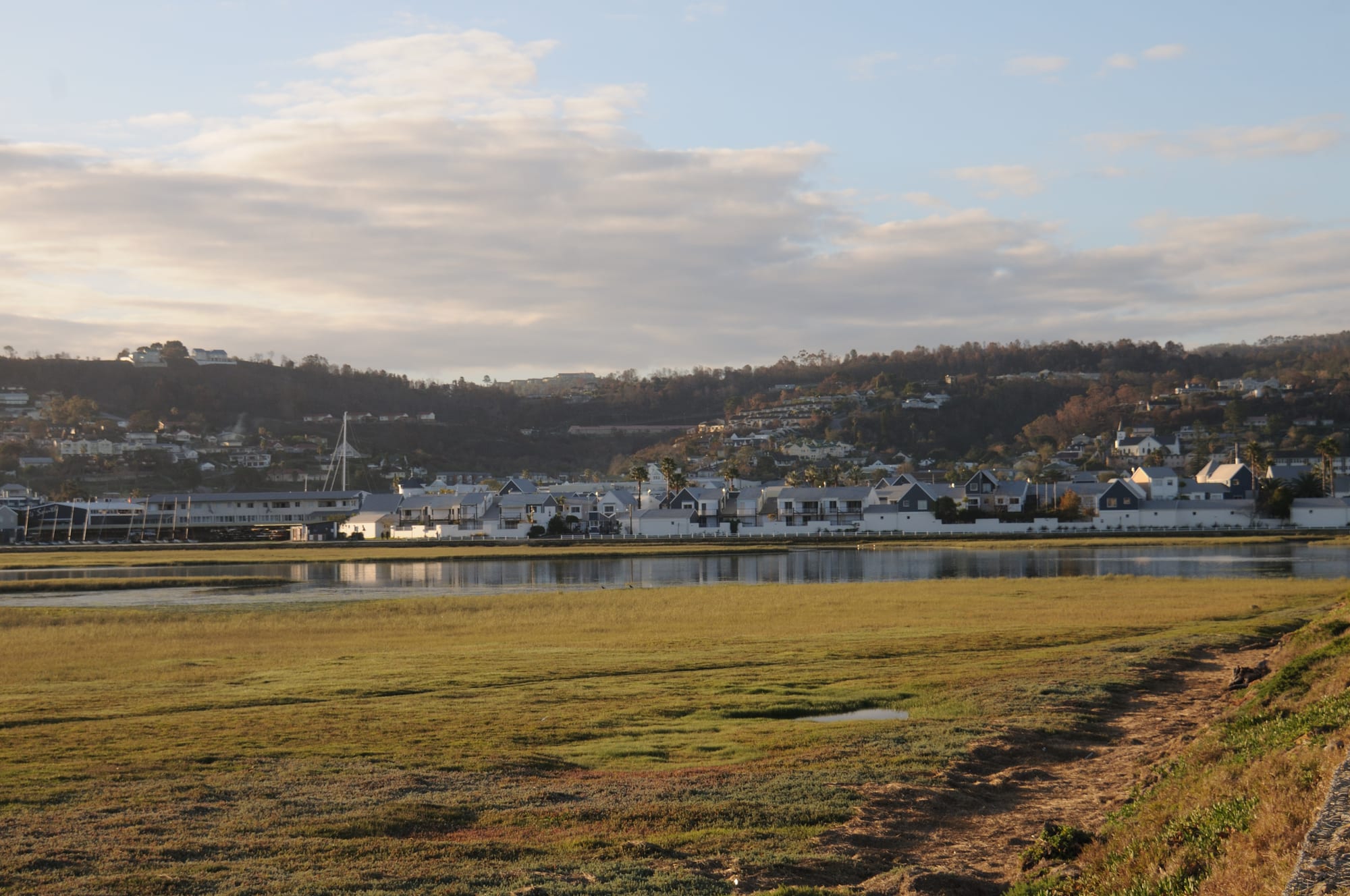
A low white town along the shore of a calm estuary with wooded hills rising behind it under a cloudy sky

Cape Town & the Western Cape, South Africa

Knysna

Knysna and its waterfront seen across the estuary from Thesen Island. (Josep M. Gracia / Wikimedia Commons · CC BY-SA 4.0)

A Garden Route town built around a tidal lagoon that reaches the sea between two sandstone cliffs, the Knysna Heads. Founded on timber and shipbuilding in the 19th century, it now lives on tourism, oysters and boating, with indigenous forest inland and the lakes and coast of the Garden Route National Park on either side.

Neighbourhoods

  • Town centre
    • First-time visitors
    • Shops and services
    • Close to transport

    The compact grid around Main Street, which is also the N2 through town, holding banks, supermarkets, craft shops, bakeries and most of the everyday business of Knysna. It sits on the slope above the water, a few minutes from the quays.

    Open in Maps
  • The Waterfront and Thesen Islands
    • Boating
    • Best for food
    • Waterside walks

    The quayside development beside the old harbour, with restaurants, boat trips and moorings, and the residential islands beyond it built on a former timber and boatbuilding site, laid out around canals and reached by a causeway.

    Open in Maps
  • Leisure Isle and the Heads
    • Quiet and residential
    • Swimming
    • Viewpoints

    A low island in the lagoon with calm tidal swimming beaches, joined to the eastern shore below the Eastern Head, where a road climbs to viewpoints over the channel to the sea. Mostly holiday houses and guesthouses, with little commercial life.

    Open in Maps
  • Brenton and Belvidere
    • Beaches
    • Quiet stays
    • Scenery

    The western side of the estuary, with the small Norman-style Belvidere church, wooded residential lanes and the long open surf beach of Brenton-on-Sea over the ridge, about 15 minutes by road from town.

    Open in Maps

Things to do

The lagoon and the coast

  • The Knysna Headsviewpoint

    The two sandstone cliffs where the estuary meets the sea, with viewpoints on the Eastern Head above a channel known for difficult, sometimes dangerous, water.

    Open in Maps
  • Knysna Lagoonattraction

    The tidal estuary at the heart of the town, a protected system of salt marsh and eelgrass beds and the home of the rare Knysna seahorse, found in only three South African estuaries, crossed daily by ferries and small boats.

    Open in Maps
  • Featherbed Nature Reservepark

    A private reserve on the Western Head, reached only by ferry from the waterfront, with coastal forest, fynbos and a walking route above the cliffs.

    Open in Maps
  • Brenton-on-Seabeach

    A long surf beach on the open ocean west of the Heads, backed by dunes and a small settlement, and much emptier than the lagoon shores.

    Open in Maps

Forest and parks

  • Garden Route National Parkpark

    The national park declared in 2009, which takes in the Knysna forests, the lakes and the coast from Wilderness east to Tsitsikamma, with walking trails and boardwalks.

    Open in Maps
  • The Knysna foreststrail

    Among the largest indigenous forests in South Africa, of yellowwood and stinkwood, with circular walks, cycling routes and the remains of 19th-century woodcutters' and gold-diggers' settlements.

    Open in Maps

Short trips from the town

  • Plettenberg Baybeach

    A resort town about 30 km east with long white beaches, a dune-backed lagoon and boat trips to see dolphins, seals and seasonal whales.

    Open in Maps
  • Robberg Nature Reservetrail

    A rocky peninsula south of Plettenberg Bay with a circular cliff-top walk, a large Cape fur seal colony and archaeological caves.

    Open in Maps
  • Wildernessneighborhood

    A small lakeside and beach village about 45 km west, at the centre of the Garden Route's chain of lakes, with forest walks to waterfalls.

    Open in Maps
  • Georgetransit hub

    The largest town on the Garden Route, about 60 km west, with the region's airport, the main hospitals and the pass roads over the Outeniqua Mountains.

    Open in Maps

Seasonal events

  • Knysna Oyster FestivalJune or July

    Ten days of sport and eating in the winter school holidays, built around oysters and including a marathon, a cycle tour and a long programme of races and markets.

  • Pink Loerie Mardi GrasApril or May

    An LGBT festival with a street parade through the centre, held in the town since 2000.

  • Whale and dolphin seasonJune to November

    Southern right and humpback whales pass along the Garden Route coast in the winter and spring months, and are seen from the Heads and on boat trips from Plettenberg Bay.

Eat and drink

Long-standing places and food districts in Knysna. Hours, ratings and directions come from your maps app, always current.

Knysna on the plate

  • Knysna oystersrestaurant

    Oysters are the town's signature, both cultivated in the estuary and wild-harvested along the coast, and are eaten on the waterfront and at the Oyster Festival each winter.

    Open in Maps
  • The Waterfront and Thesen Islands restaurantsneighborhood

    Most of the town's seafood kitchens, breweries and bars sit along the quays and on the causeway island, looking over the water to the Heads.

    Open in Maps
  • Main Street cafés and bakeriesneighborhood

    The through road holds the everyday eating — coffee shops, bakeries, butchers selling biltong and boerewors, and takeaways used by residents rather than visitors.

    Open in Maps

Local specialities

  • Line fish and seafoodrestaurant

    Kob, yellowtail, kingklip and calamari come off the Garden Route coast, usually grilled simply and served with chips or samp.

    Open in Maps
  • Garden Route farm producemarket

    Weekend markets in and around the town sell cheeses, preserves, honey, berries and bread from the smallholdings of the surrounding valleys.

    Open in Maps

Experience Knysna

History

Khoekhoe herders and San hunter-gatherers lived around the estuary and in the forests long before Europeans settled, and the woodcutters who followed found a vast belt of indigenous timber running inland. The first Europeans reached the area in 1760, and the settlement grew after George Rex, a British-born entrepreneur credited as the founder of Knysna, acquired the lagoon farm Melkhoutkraal in 1804 and developed farms and a timber trade. Ships began crossing the bar between the Heads in the 1810s, a dangerous passage that wrecked many vessels but made Knysna a port.

Timber built the town. Yellowwood and stinkwood were cut for buildings, wagons, railway sleepers and furniture, and small settlements of woodcutters lived deep in the forest in poverty, a life recorded in Dalene Matthee's novels. A gold rush at Millwood, the first goldfield declared in South Africa, brought a brief boom and left a ghost town. Shipbuilding and boatyards worked at the water's edge, and a branch railway reached the town, carrying timber out and later tourists in.

In the 20th century the forests were placed under state protection as the stands thinned, the elephants that once roamed them dwindled to a remnant that is now rarely seen, and the economy shifted towards holidaymaking as the Garden Route became one of South Africa's main tourist drives. In June 2017 a fire driven by strong winds from a severe storm swept through the town and the surrounding areas, killing nine people directly and two indirectly and displacing about 10,000; rebuilding and arguments about plantation management and building in the fire-prone urban edge followed.

Culture & Customs

Knysna's identity is bound to the water and the trees. Boating, rowing, paddling and fishing structure weekends, the estuary's ecology is a matter of local pride and local argument, and woodworking survives as a craft: furniture makers and carvers still work yellowwood and other indigenous timbers, and the old woodcutters' story is part of the town's self-image.

The population is mixed: Afrikaans- and English-speaking families with long roots in the timber and boat trades, a large coloured community, and isiXhosa-speaking residents whose families came from the Eastern Cape for work. The town also has a long-established Rastafarian community, which holds an Earth Festival at the end of July celebrating Rastafarian religion, culture and lifestyle.

The town's calendar runs on festivals. The Oyster Festival in the winter school holidays combines eating with a marathon, a cycle tour and races through the forest, and the Pink Loerie Mardi Gras has brought a street parade to the centre since 2000, making Knysna unusual among small South African towns for its open LGBT scene. Art galleries, craft breweries and a music and theatre programme keep the season going outside the summer peak, and the pace everywhere is slow and informal.

Daily Life

About 76,000 people live in Knysna, a number that swells many times over in the December holidays when traffic on the N2 backs up through the centre. Tourism, construction, retail, forestry and boatbuilding provide most work, along with the services that support a large retired population drawn by the climate.

The town's geography maps its inequality. Comfortable houses look over the lagoon from the ridges, Leisure Isle and Thesen Islands, while most residents live in the townships and informal settlements north of the N2 — Khayalethu, Hornlee and the hillside areas that were worst hit by the 2017 fires. Housing shortages, unstable seasonal work and the cost of living are constant local issues, and rebuilding after the fires took years.

Daily rhythms follow the season and the tide: early starts for building and delivery work, quiet weekday afternoons in the shoulder months, full restaurants and packed boat trips in December. Water supply is a recurring worry in a town that has faced severe restrictions in drought years, and the rotating national power cuts that shaped routines for years eased markedly in 2024 and 2025.

Food

Oysters are the town's emblem. Cultivated in the estuary and gathered wild along the coast, they are eaten plain with lemon on the waterfront and are the centre of the winter festival that draws thousands of people to the town. Mussels, prawns, calamari and line fish — kob, yellowtail, kingklip — fill the rest of the seafood menus, usually grilled and served with chips, rice or samp.

Away from the water, this is Cape country cooking: braaied boerewors and lamb, potjiekos slow-cooked outdoors, bobotie, biltong and droëwors from the butchers on Main Street, and milk tart or malva pudding to finish. Smallholdings in the surrounding valleys supply cheeses, honey, berries, free-range eggs and preserves that turn up at weekend markets and in farm shops along the N2.

The town brews and pours its own: craft breweries work on Thesen Islands and in the industrial edge of town, and the wine comes from cool-climate vineyards in the Outeniqua foothills and further west, along with the Cape's better-known regions. Rooibos tea, drunk plain or with milk, is as common here as anywhere in the Western Cape, and the forest is the source of honey and, historically, of the wild honeybush used to make a second bush tea.

Planning tools

Budget

Knysna is cheaper than Cape Town outside the peak weeks but prices double in the December and January holidays and over the Oyster Festival, when the town fills. Self-catering flats and guesthouses are the usual accommodation, and boat trips, the Featherbed ferry and national park entry are the main extra costs.

Daily Budget Midrange
USD 150–310 (guesthouse or boutique hotel, restaurant dinners, car hire, boat trips)
Daily Budget Shoestring
USD 45–80 (backpacker or self-catering, cooking, walking and occasional ride-hailing)

Book accommodation months ahead for late December and for the Oyster Festival; forest and lagoon walks and the Heads viewpoints cost little or nothing.

Best Time to Visit

February to April gives warm, settled weather and thinner crowds once the South African school holidays end. December and January are hot and very busy. Winter, June to August, is cool and often wet but brings whales, the Oyster Festival and low prices; rain falls in every season along this coast.

Suggested Number of Days

Two days cover the lagoon, the Heads and a forest walk. Four or five allow the wider Garden Route on either side. Weather, interest in walking or boating, and whether the visit is part of a longer coastal drive are what change the number.

First Visit
2 days
With Surroundings
4–5 days

Transportation

Almost everyone arrives and moves around by car; the N2 runs through the centre and links the Garden Route towns. Ride-hailing and metered taxis operate in town but are thin outside it, and minibus taxis serve residents rather than visitors. Ferries cross the lagoon to Featherbed and the Heads, and bicycles are useful on the flat ground near the water.

Parking in the centre is limited in the holidays, and car guards expect a few rand; the roads through the forest are narrow and used by logging trucks.

Airport & Station Connections

George Airport is about 60 km west, roughly an hour by road, with flights from Johannesburg, Cape Town and Durban; Cape Town itself is about 500 km away, a six- to seven-hour drive along the N2, and Port Elizabeth roughly 270 km east. Intercity coaches stop in town on the coastal route between the two cities.

Walkability

The centre, the waterfront and Thesen Islands are easily walked, and paths run along parts of the lagoon shore and around Leisure Isle. The Heads, Brenton and the forest trailheads are too far to reach on foot from town, and the N2 through the middle carries heavy traffic, so crossing it needs care.

Safety

Knysna is generally calm by South African standards, and the risks visitors meet are theft from parked cars at trailheads and viewpoints, opportunistic break-ins at holiday houses and petty crime in the centre after dark. The water is the greater hazard: the channel between the Heads has strong currents and has caused many boating deaths, and the surf beaches are not always guarded.

Violent crime rates are high, but most of it is concentrated in areas visitors do not go; the main tourist routes — Cape Town centre, the Winelands, the Garden Route, Kruger and the private reserves — are heavily travelled and generally fine with sensible precautions. Leave nothing visible in a parked car, swim where lifeguards are on duty, and take local advice before taking a boat through the Heads. Check current official travel advice before travelling.

Climate

Mild and humid, with rain spread through the year rather than falling in one season as it does around Cape Town. Seasons are reversed from the northern hemisphere: summer runs from December to February and winter from June to August. Sea fog and cloud roll in off the Indian Ocean at any time of year.

Summer
warm and humid, usually 18–27°C, with afternoon sea breezes
Winter
cool and damp, usually 8–19°C, with passing cold fronts and clear spells

Local Customs

Afrikaans, English and isiXhosa are all spoken. Dress is informal almost everywhere, including in restaurants. Tipping is about 10 to 15 per cent, with a few rand for car guards and petrol attendants, who fill the tank for drivers. The forest and the lagoon are closely tied to local identity, and the 2017 fires are a sensitive subject for many households.

Ask before photographing people or homes, keep to marked paths in the forest and reserves, and follow fire restrictions in dry, windy weather.

Common Payment Methods

The currency is the South African rand (R, ZAR). Cards are accepted by shops, restaurants, boat operators and fuel stations, and contactless payment is normal. Cash is worth carrying for market stalls, small takeaways, tips and car guards. ATMs are in the centre and the supermarkets.