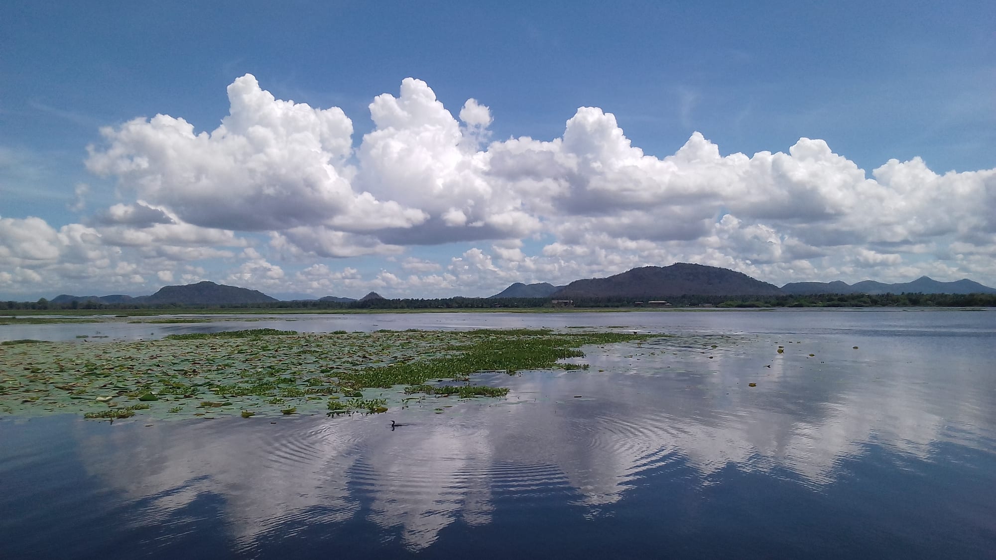
A wide, still reservoir with rafts of water lilies in the foreground and low hills under tall white clouds beyond

Galle & the South Coast, Sri Lanka

Tissamaharama

The Tissa Wewa reservoir beside the town of Tissamaharama in south-eastern Sri Lanka. (Kasuni Amarasinghe / Wikimedia Commons · CC BY-SA 4.0)

A town in the dry south-east of Sri Lanka, in Hambantota District, built beside ancient irrigation reservoirs and dominated by a great white stupa. As Mahagama it was the seat of the Ruhuna kingdom more than two thousand years ago; today it is a farming centre and the main base for jeep safaris into Yala National Park.

Neighbourhoods

  • The town centre and the stupa
    • First-time visitors
    • Close to public transport
    • Historic district

    The compact centre around the bus stand, the market and the great white dagoba, with shops, bakeries and small hotels. Most of the ancient monuments lie within a short ride, and safari jeeps collect guests from here before dawn.

    Open in Maps
  • The bund of the Tissa Wewa
    • Quiet and residential
    • Lake views
    • Birdwatching

    The embankment road along the reservoir, lined with old trees full of roosting bats and birds, with guesthouses and small hotels looking over the water. It is the pleasant side of town, busiest at sunset.

    Open in Maps
  • Debarawewa and Weerawila
    • Quiet and residential
    • Local life

    Neighbouring settlements on the road west, beside their own tanks and paddy land, with schools, a hospital and local shops. Accommodation here is cheaper and the surroundings are rural.

    Open in Maps
  • Kirinda
    • Beaches
    • Quiet and residential

    A fishing village on the coast about ten kilometres south, with a rocky headland, a temple above the sea and a wide beach. It is the nearest sea to the town and lies on the road towards Yala's main entrance at Palatupana.

    Open in Maps

Things to do

Ancient sites

  • Tissamaharama Raja Maha Viharalandmark

    The town's great white stupa, traced to the third or second century BC and among the largest in the country, still an active place of pilgrimage.

    Open in Maps
  • Mulkirigala Raja Maha Viharalandmark

    A rock temple west of the district, with cave shrines, reclining Buddha images and painted ceilings on terraces climbing the rock.

    Open in Maps

Water and wildlife

  • Tissa Wewaattraction

    The ancient reservoir beside the town, attributed to the kings of Ruhuna and still irrigating paddy land, with water birds, lotus and fruit bats in the trees along its bund.

    Open in Maps
  • Yala National Parkattraction

    Dry forest, lagoons and rock outcrops east of the town, known for its leopards, recorded here at a high density, along with elephants, sloth bears and crocodiles.

    Open in Maps
  • Bundala National Parkattraction

    A Ramsar wetland of lagoons and salt pans west of the town, a wintering ground for flamingos and many migratory waders.

    Open in Maps
  • Lunugamvehera National Parkattraction

    A park around a large reservoir north-west of the town, forming a corridor for elephants moving between Yala and Udawalawe.

    Open in Maps

Short trips

  • Kataragamalandmark

    A pilgrimage town about 15 kilometres north, sacred to Buddhists, Hindus, Muslims and the Vedda people, whose July and August festival draws great crowds.

    Open in Maps
  • Kirindabeach

    A fishing village on a rocky headland south of the town, with a temple above the sea and wide sand, remembered as the place where the legendary queen Viharamahadevi came ashore.

    Open in Maps
  • Hambantotaattraction

    The district capital down the coast, with salt pans, a large port and a long history as a trading and fishing town.

    Open in Maps

Seasonal events

  • Kataragama Esala festivalJuly or August

    Processions, drumming and kavadi dancing at the shrines of the nearby pilgrimage town, when the whole area fills with pilgrims.

  • VesakMay full moon

    Lanterns and illuminated pandals are set up around the stupa and the town for the full moon marking the Buddha's birth, enlightenment and death.

  • PosonJune full moon

    The full moon marking the arrival of Buddhism in Sri Lanka, when temples fill and roadside almsgivings feed travellers.

  • Sinhala and Tamil New YearApril

    The harvest new year, celebrated with sweets, games and family visits; shops and transport slow for several days.

Eat and drink

Long-standing places and food districts in Tissamaharama. Hours, ratings and directions come from your maps app, always current.

Tissamaharama classics

  • Rice and curry with curdrestaurant

    The dry-zone meal of rice with dhal, vegetable curries and pol sambol, often followed by buffalo curd from the surrounding villages with kithul treacle.

    Open in Maps
  • Freshwater fish and prawnsrestaurant

    Fish from the tanks and prawns from the coastal lagoons appear in red curries and fried dishes on local menus.

    Open in Maps

Markets and food streets

  • Tissamaharama marketmarket

    The town's produce market, with bananas, papaya, curd pots, dried fish and vegetables from the irrigated land around.

    Open in Maps
  • The main street eating housesneighborhood

    Bakeries and small kitchens near the bus stand serve short eats, roti, kottu and early breakfasts for safari-goers.

    Open in Maps

Experience Tissamaharama

History

Tissamaharama stands on the site of Mahagama, the capital of Ruhuna, the southern principality that formed one of the three divisions of ancient Sri Lanka. Tradition places its founding in the third century BC under Mahanaga, a brother of the Anuradhapura king Devanampiya Tissa, and it was from here, in the second century BC, that the prince Dutugemunu set out on the campaign that ended with his defeat of Elara at Anuradhapura and the unification of the island — a story central to Sinhalese historical memory.

The kingdom's wealth came from irrigation. Kings dammed the Kirindi Oya and built the Tissa Wewa and other reservoirs, turning dry scrub into paddy land, and monasteries followed: the great stupa of the Tissamaharama vihara, the Yatala Wehera and, out in the jungle, the rock monastery of Sithulpawwa. The port of Kirinda and the nearby coast connected Ruhuna to Indian Ocean trade, and excavations around the town have turned up evidence of those long-distance connections.

Ruhuna served repeatedly as a refuge when the northern capitals fell to invasion, and armies of reconquest were raised here more than once. After the medieval kingdoms moved south-west, however, the irrigation works decayed, malaria spread and the district emptied; the ruins lay in jungle until the 19th and 20th centuries, when the British and then independent Sri Lanka restored the tanks and resettled farmers under new colonisation schemes. Tissamaharama grew back as an agricultural town. Since the 1970s, and more so after the end of the civil war in 2009, safari tourism to Yala has become its second livelihood.

Culture & Customs

The town's identity is bound up with Ruhuna and with pilgrimage. The great dagoba is a working temple rather than a monument: on poya full-moon days families come in white with lotus flowers and oil lamps, and almsgivings are set up along the roads. Monks are prominent in public life, and the monasteries in the surrounding jungle keep a strong forest-meditation tradition.

About fifteen kilometres north lies Kataragama, one of the most unusual religious places in South Asia, where Buddhists, Hindus, Muslims and the indigenous Vedda community worship at adjoining shrines to the god Skanda, known here as Kataragama deviyo. Its Esala festival in July or August brings processions, drumming and kavadi dancing, and pilgrims from Tissamaharama and far beyond. Vows made at Kataragama, and the coconut smashed at the shrine, are part of everyday religious practice across the south.

Rural custom governs much of daily behaviour: shoes off at temples, the right hand used for eating and giving, respect shown to elders and monks, and modest dress. Village life still turns on the tank, the paddy calendar and the temple, and traditional beliefs about the guardian deities of fields and forests persist alongside orthodox Buddhism. Visitors are common enough not to attract attention, but safari-town manners — early nights, early starts — set the rhythm of the tourist side of town.

Daily Life

The town has a population in the tens of thousands, part of a Hambantota District of roughly 600,000 people. Farming is the base: paddy under the restored ancient tanks and the Kirindi Oya irrigation scheme, together with bananas, papaya, chillies and onions, and cattle and buffalo whose milk becomes the curd sold along the roads. Fishing at Kirinda and the coastal lagoons, salt from the Hambantota pans and government employment fill out the local economy.

Tourism is the other pillar. Jeep drivers, guides, guesthouse owners and cooks depend on Yala, and the town wakes before dawn as vehicles leave for the park gates. The trade collapsed during the pandemic and again during the fuel shortages of the 2022 economic crisis, and its recovery has mattered greatly to household incomes. The large Chinese-financed projects in the district — the port, the airport and the conference hall — brought less local employment than was hoped.

Days start early in the fields and end soon after dark. Human–elephant conflict is the district's sharpest problem: elephants raid crops and break fences, and people and animals are killed each year. Water management, crop prices and the crowding of Yala by too many jeeps are the other recurring local arguments, alongside concern about the long-term effects of drought.

Food

Cooking here is dry-zone and coastal at once. The daily meal is rice and curry: rice with parippu, the dhal curry, a green such as gotu kola sambol or mallung, fried aubergine in sweet and sour moju, and pol sambol of grated coconut with chilli, lime and dried fish. Freshwater fish from the tanks is fried or cooked in a red curry sharpened with goraka, and prawns and crab come up from the lagoons and the coast at Kirinda.

Curd is the district's best-known product. Buffalo milk is set in unglazed clay pots in the villages around the town and eaten with kithul treacle or palm jaggery; roadside stalls sell it by the pot along the main routes. Kurakkan, finger millet, is made into dark roti and porridge, and jackfruit, breadfruit and cowpeas from the chena plots appear in season. Wood-apple, divul, is beaten into a thick juice, and thambili, the orange king coconut, is opened at the roadside for its water.

Evening food is the same across the south: hoppers with an egg in the middle, string hoppers with a thin curry and sambol, pittu steamed with coconut, and kottu chopped noisily on a hot plate. Bakeries turn out fish buns, rolls and patties for the afternoon, and strong sweet tea is drunk through the day. During the Kataragama festival, stalls and free almsgivings feed pilgrims on a very large scale, and sweets such as kavum and kokis are made for the April new year.

Planning tools

Budget

The town itself is inexpensive, with guesthouses along the bund and simple eating houses in the centre, and a handful of more comfortable hotels and tented camps out towards the park. The dominant cost is Yala: park entrance fees for foreigners are set in US dollars and a jeep with a driver is charged on top, usually per half-day trip.

Daily Budget Midrange
USD 90–210 (hotel or tented camp, restaurant meals, a jeep safari with park fees, a car and driver)
Daily Budget Shoestring
USD 25–45 before park fees (guesthouse, rice and curry, buses and tuk-tuks)

Sharing a jeep cuts the cost of a safari sharply, and Bundala and Lunugamvehera are cheaper and far less crowded than Yala.

Best Time to Visit

February to June or July is the dry season here and the best time for wildlife, when water is scarce and animals gather at the remaining pools; Yala's main block closes to visitors for a period each year, so the dates are worth checking. October to January brings the north-east monsoon rains, greener country and migratory birds at Bundala.

Suggested Number of Days

A night or two is enough for the town and a safari. Three or four days allow more than one park, the ancient sites and the coast. Travellers crossing between the south coast and the east often stop here for a single night.

First Visit
1–2 days
With Surroundings
3–4 days

Transportation

The town is small and tuk-tuks cover it easily. Safari jeeps with drivers are hired through hotels and operators and leave very early or in the mid-afternoon. Buses run to Hambantota, Matara, Kataragama and Colombo from the central stand, and the railway line from Matara has been extended as far as Beliatta, some way west, so most arrivals are by road.

Book a jeep through the hotel the night before, and take a jacket for an open vehicle at dawn.

Airport & Station Connections

Tissamaharama lies on the main southern road about 260 kilometres from Colombo, typically five to six hours by car using the Southern Expressway and the coast road, and about two hours from Matara. Buses run from Colombo, Matara and Kataragama. Mattala airport near Hambantota has few flights, so most visitors arrive overland from the coast or the hill country.

Walkability

The centre is compact and flat, and the bund of the reservoir makes an easy walk of a few kilometres with birds and water views. Beyond that, distances between the town, the ancient sites and the park entrances are too great to walk in the heat, and the roads carry fast traffic with little shade, so tuk-tuks or a hired vehicle are the practical choice.

Safety

Crime is low. The hazards are wildlife and heat: elephants move along roads around the parks and villages, especially at dusk, crocodiles live in the tanks and lagoons, and swimming in the reservoirs is dangerous. Inside the parks, jeeps sometimes crowd animals or break the rules. Sunburn and dehydration are constant risks on open safari vehicles.

Do not swim in the tanks or lagoons, avoid driving rural roads after dark because of elephants, and stay inside the vehicle in the national parks. Check current official travel advice before travelling.

Climate

Hot and semi-arid, usually 27–33°C by day with little seasonal change in temperature. Most rain comes with the north-east monsoon from October to January, sometimes heavily; the rest of the year is dry, dusty and hot, and the tanks and waterholes shrink until the animals concentrate around them.

Summer
May–September: hot, dry and windy, around 28–33°C, with parched scrub and good wildlife viewing
Winter
October–January: the rainy season, with heavy showers, green country and migratory birds, around 24–31°C; February–April dry and very hot, often above 33°C

Local Customs

This is a devout Buddhist area with Kataragama's multi-faith shrines nearby, and religious observance is public. Shoes and hats are removed at the stupa and temple precincts, shoulders and knees covered, and white clothing is usual for worshippers. Alcohol is not sold on poya days and is out of place around the sacred sites; Kataragama's precinct is treated with particular respect.

Cover up at religious sites, never turn one's back on a Buddha image for a photograph, and ask before photographing pilgrims or rituals.

Common Payment Methods

The currency is the Sri Lankan rupee. Hotels, safari operators and the park ticket offices generally accept cards, and park fees for foreigners are quoted in US dollars. Guesthouses, tuk-tuks, market stalls and small restaurants want cash, and ATMs are in the town centre.