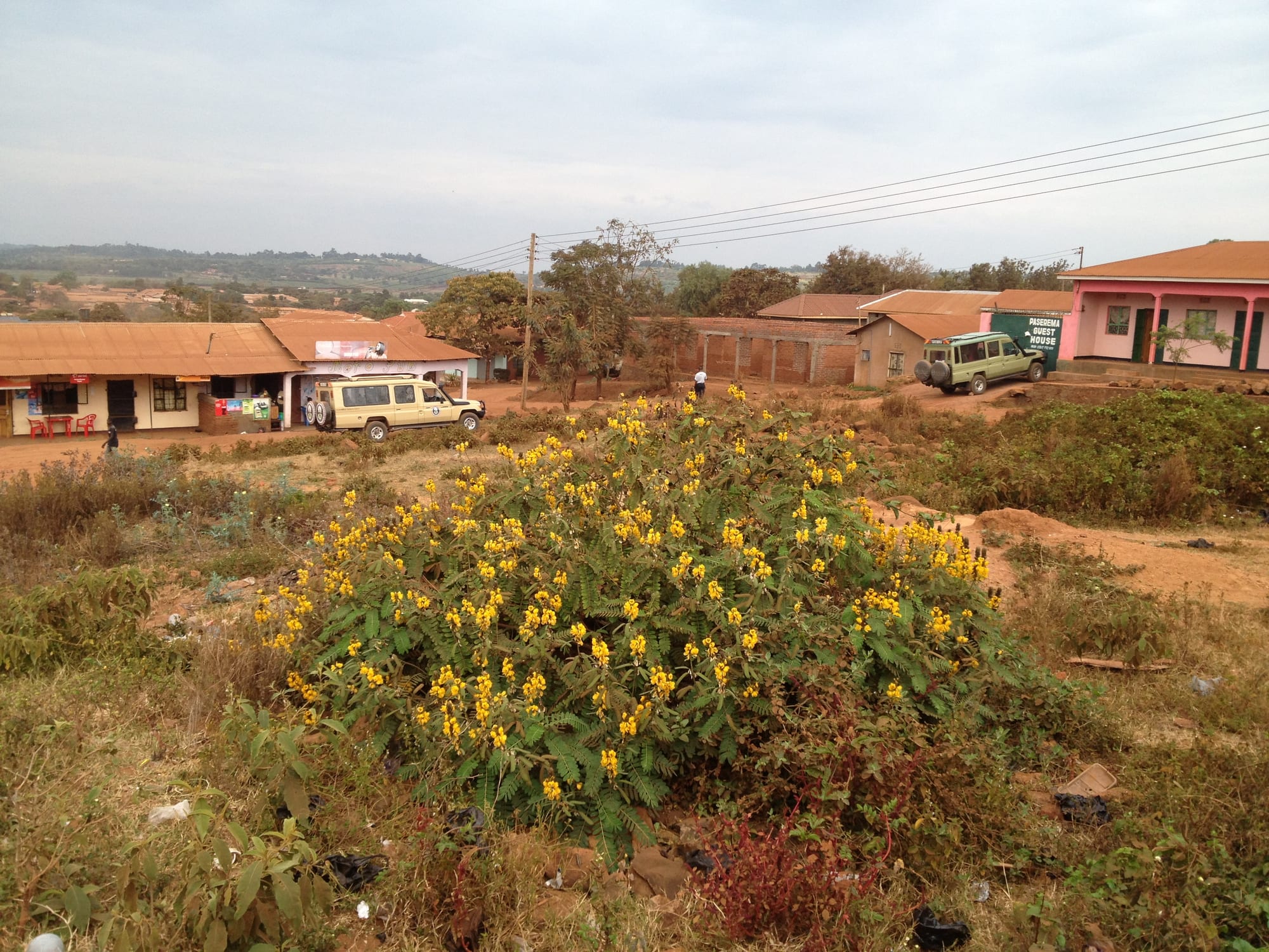
A dusty street of small shops and tin-roofed buildings in Karatu with safari vehicles parked outside and farmed hills behind

Arusha, Kilimanjaro & the Northern Safari Circuit, Tanzania

Karatu

Shops and safari vehicles on the main road through Karatu, with the farmed highlands behind. (Michelle Maria / Wikimedia Commons · CC BY 3.0)

A farming town in northern Tanzania on the road between Lake Manyara and the Ngorongoro Conservation Area, set on red volcanic soil about 1,500 metres up. Wheat, maize and coffee grow on the surrounding highlands, home to the Cushitic-speaking Iraqw, and the safari traffic heading for the crater has made the town the usual overnight stop on the way.

Neighbourhoods

  • Town centre
    • First-time visitors
    • Markets
    • Close to public transport

    A single long main street along the Arusha–Ngorongoro road, lined with shops, hardware stores, banks, bus offices and small restaurants. It is busiest on market days and in the early morning, when safari vehicles refuel before the climb to the crater rim.

    Open in Maps
  • The road west towards the conservation gate
    • Lodges and farms
    • Quiet and residential

    Beyond the town the tarmac climbs through coffee and maize fields towards the Ngorongoro entrance gate, and most of the district's lodges and camps stand off it among farmland and stands of forest. Nights are cool and dark, with the highlands above.

    Open in Maps
  • Rhotia and the eastern farms
    • Local life
    • Countryside walks

    The farming country back towards the Rift Valley wall, where villages sit among maize, beans and cattle on the ridges. It is ordinary working countryside rather than a sight, and the views over the escarpment towards Lake Manyara are wide.

    Open in Maps

Things to do

The Ngorongoro highlands

  • Ngorongoro Conservation Areapark

    The protected area west of the town, a UNESCO World Heritage Site listed in 1979, where Maasai herding and wildlife share the highlands and the great caldera of the Ngorongoro Crater.

    Open in Maps

Short trips from the town

  • Olduvai Gorgeattraction

    The ravine on the eastern Serengeti plains inside the conservation area, where Mary and Louis Leakey's excavations made it one of the most important sites for human origins, with a museum on the rim of the gorge.

    Open in Maps
  • Lake Manyara National Parkpark

    A narrow park at the foot of the Rift Valley wall east of Karatu, with groundwater forest, a hippo pool, thousands of flamingos feeding along the lake edge in the wet season, and lions known for climbing trees.

    Open in Maps
  • Lake Eyasiattraction

    A shallow salt lake in the Rift south-west of the town, in country where Hadza hunter-gatherer and Datooga herding communities live.

    Open in Maps
  • Mto wa Mbuneighborhood

    The market village below the escarpment at the Lake Manyara park gate, known for its banana groves, irrigated plots and unusual mix of languages.

    Open in Maps

In and around the town

  • Karatu marketmarket

    The town's produce market, at its largest on the 7th and the 25th of each month, with a smaller daily market in the centre, where farmers from the highlands bring maize, beans, vegetables, honey and livestock.

    Open in Maps
  • The coffee and wheat farmsattraction

    The red-soil highlands around the town grow arabica coffee, wheat and maize, and several farms open their fields and pulperies to visitors.

    Open in Maps

Seasonal events

  • Nane Nane farmers' day8 August

    The national agricultural day, marked in a district that lives by farming with shows of crops, seed, livestock and machinery.

  • Harvest seasonroughly June to September

    The dry months when wheat and maize come off the highland fields, the busiest time in the town's mills, stores and market.

  • Coffee harvestroughly July to December

    The season when cherries are picked on the highland farms and taken to the pulperies, and farm visits are at their most interesting.

Eat and drink

Long-standing places and food districts in Karatu. Hours, ratings and directions come from your maps app, always current.

Karatu markets and food streets

  • Karatu marketmarket

    Highland produce at its plainest and freshest — maize, beans, potatoes, bananas, honey and vegetables from the surrounding farms, with cheap cooked food sold at the edges.

    Open in Maps
  • Main-road local restaurantsneighborhood

    Small places along the main street serving ugali, rice, beans, greens and stew to drivers, traders and guides, with chapati made from local wheat.

    Open in Maps
  • Nyama choma grillsneighborhood

    Charcoal grills and bars on and off the main road, where goat and beef are roasted, chopped on a board and eaten with kachumbari salad.

    Open in Maps

Coffee

  • Farm coffeecafe

    Arabica from the Karatu highlands is sold abroad through the trade, and farms and a few cafés along the main road serve it roasted and ground on the spot.

    Open in Maps

Experience Karatu

History

Karatu lies in the highlands that rise between the Rift Valley wall and the Ngorongoro crater, country long farmed by the Iraqw, a Cushitic-speaking people whose language is unrelated to those of their Bantu and Nilotic neighbours and who built terraced, manured fields and cattle byres in the hills around Mbulu. The Datooga, Nilotic herders, share the district, and Maasai grazing lands begin on the plains to the west and north.

Colonial rule brought commercial farming to the volcanic soils. German and later British settlers planted wheat, coffee and other cash crops on the highlands, and the road climbing from the Rift wall towards the crater made the settlement a staging point for goods coming down from the farms and going up to the highlands. In 1959 the Ngorongoro Conservation Area was created immediately to the west as a place where Maasai herding and wildlife would share the land, fixing a hard boundary just beyond the town: farming stopped, and the country beyond became protected.

That boundary has shaped Karatu ever since. When Tanzania's northern parks grew into an international destination from the 1980s, the last town with fuel, banks, shops and beds before the conservation gate became the place where safaris spent the night, and lodges and camps spread along the road west. The town is now the centre of Karatu District, one of the more prosperous farming areas in northern Tanzania, with an economy standing on two legs — the harvest and the crater traffic.

Culture & Customs

This is one of the most mixed districts in northern Tanzania. The Iraqw are the largest community, farmers with a reputation for careful, intensive cultivation, and their language, Iraqw, is widely spoken alongside Swahili; older people in the villages may use it in preference. The Datooga, Nilotic cattle-keepers closely related to the Kalenjin of Kenya, live across the district, and Maasai families come into the town from the grazing lands to buy and sell. Around Lake Eyasi to the south-west, Hadza communities still live partly by hunting and gathering and speak a click language unrelated to any other.

Christianity, both Catholic and Lutheran, is the dominant faith, with churches prominent in the town and in the farming villages, and Muslim traders long established along the main street. Older beliefs and customs remain part of rural life, particularly among the herding communities.

Cultural tourism is part of the local economy, with arranged visits to Hadza and Datooga camps near Lake Eyasi and to Iraqw farms in the highlands. These are paid, organised encounters rather than chance ones, and their fairness is debated in Tanzania as much as anywhere. The ordinary courtesies of the region hold: greetings before anything else, respect for elders, modest dress and a slow, unhurried manner in public.

Daily Life

About 27,000 people lived in the town ward at the 2012 census, and Karatu District as a whole counted some 280,000 in 2022, in wards and villages that make up one of the most densely farmed parts of the north. Karatu works to two rhythms. The farming year turns on the rains, with ploughing, planting and then the wheat and maize harvest that fills the mills and stores from around June; the safari year turns on the dry season, when vehicles pass through the town from early morning and the lodges along the crater road fill.

The main street carries everything: banks, fuel, hardware and agricultural suppliers, mobile-money kiosks, bus offices, tour company branches, guesthouses and small restaurants. Away from it, houses stand among plots of maize and beans, and cattle are walked along the verges. Work for local people comes from farming, from the lodges and camps as cooks, cleaners, drivers and guides, and from trade.

The district's current issues are those of a farming town beside a protected area: pressure on land as families subdivide their fields, water supply, wildlife moving on to crops from the conservation area, and the wider tension between the authorities and Maasai communities inside Ngorongoro, where families have been moved out to a village hundreds of kilometres away in a programme the government describes as voluntary and human rights organisations dispute. The unrest that followed the October 2025 election touched the region as well.

Food

Karatu eats what it grows. Maize becomes ugali, the stiff porridge that goes with almost everything, and is also eaten green and roasted on the cob at the roadside. Wheat from the highland fields turns into chapati, the flatbread served with beans or stew, and into mandazi, the lightly sweet fried dough eaten with tea. Beans, potatoes, pigeon peas, greens such as mchicha and sukuma, and highland vegetables fill the market, along with local honey from hives in the forest edges.

Meat is eaten the way it is eaten across the north: nyama choma, goat or beef grilled slowly over charcoal, chopped on a wooden board and served with kachumbari, a raw salad of tomato, onion, chilli and lime, and a dish of salt. Cattle-keeping families drink and cook with milk, sometimes soured, and rice is the food of celebration. Chips mayai, the chip omelette, and samosas are the usual quick meals along the main road.

The district's cash crop is coffee. Arabica grown on the red volcanic soil around the town is sold through the trade abroad, and farms along the road west show the process from cherry through pulping and drying to a cup roasted in a pan. Tea with milk and a great deal of sugar is the everyday drink, and home-brewed maize and millet beers are made in the villages.

Planning tools

Budget

The town itself is cheap — guesthouses, local restaurants and buses cost little — but almost everyone here is on a safari, and that is where the money goes. Conservation fees for Ngorongoro are charged per person per day, with a separate vehicle fee for descending into the crater, and a 4x4 with a driver-guide is needed. Lodges along the crater road are priced for that trade.

Daily Budget Midrange
USD 260–680 per day on a guided safari (vehicle, guide, park fees, lodge or tented camp)
Daily Budget Shoestring
USD 35–65 (guesthouse in town, local food, buses and shared minibuses)

Check exactly which conservation and crater fees a quote includes, and consider staying in the town rather than on the rim, where rooms cost far more.

Best Time to Visit

June to October is the dry season, the peak for game viewing in the crater and in Lake Manyara and the easiest time on the roads. January to March is warmer and coincides with the calving season on the Serengeti plains to the west. The long rains of April and May bring green farmland, low prices and heavy mud on the side roads.

Suggested Number of Days

Most visits are one or two nights, built around a day in the conservation area. Three or four allow for the Rift Valley lakes, a farm visit and time in the highland countryside. Longer stays suit those using the town as a base for the wider circuit.

First Visit
1–2 days
With Surroundings
3–4 days

Transportation

Almost all visitors arrive in a safari vehicle with a driver-guide, which stays with them. Otherwise the town is served by buses and shared minibuses along the Arusha road, through Mto wa Mbu and on towards the conservation gate, and by motorcycle taxis and bajaji for short local trips. The main street is walkable; everything beyond it is spread out along the highway and farm tracks.

Private vehicles need a permit and guide arrangements for the conservation area, so the crater is not somewhere to drive to on impulse; unpaved side roads turn heavy after rain.

Airport & Station Connections

Karatu sits on the tarmac road from Arusha to the Ngorongoro gate, roughly three hours' drive from Arusha and about half an hour beyond Mto wa Mbu. Kilimanjaro International Airport is the nearest international gateway, a long half-day away by road, and light aircraft serve airstrips at Lake Manyara and in the conservation area. Buses from Arusha run through the town daily.

Walkability

The centre is a straight, flat main street that takes a few minutes to walk from end to end, with shops, market and bus offices along it. The lodges, farms and the conservation gate are strung out along the highway beyond, too far to walk comfortably and on a road with fast traffic and no pavement. Dust in the dry season and mud in the rains both slow things down.

Safety

Karatu is a quiet farming town and the safari trade is well established. The main risks are the highway itself, with heavy traffic and no footpaths, petty theft around the bus stand and market, and wild animals, which move freely through the conservation area and sometimes on to farmland. Nights at this altitude are cold, and malaria risk is lower here than in the lowlands but not absent.

Climb with a licensed operator and ascend slowly, stay in the vehicle unless a guide says otherwise, and use taxis at night. Walk the highway with care, take malaria precautions in the lowlands nearby, and treat visits to Hadza or Maasai communities as arranged, paid visits made with respect. Check current official travel advice before travelling.

Climate

Highland climate at about 1,500 metres: warm days, cool nights and cooler still on the crater rim above. The long rains fall from roughly March to May and shorter rains around November, and the district is green and muddy through them. Southern-hemisphere summer falls in December to February.

Summer
December to March is warm, with days around 25–28°C and afternoon storms in the wetter weeks
Winter
June to August is dry and cool, with days near 22–24°C and nights that can drop to around 10°C, colder on the rim

Local Customs

Greetings come before business, and shikamoo is the respectful greeting to an elder. Dress is modest in town. Tipping the safari driver-guide and lodge staff at the end of a trip is customary and is a real part of their income. Maasai and Hadza communities in the surrounding country receive organised visits, and photographs are expected to be asked for and paid for rather than taken freely.

Ask before photographing people, livestock or homesteads; dress modestly away from lodges; and buy from local farms and markets where possible, since the district's income from visitors is thinly spread.

Common Payment Methods

The currency is the Tanzanian shilling, used for markets, shops and buses. US dollars are standard for conservation fees, safaris and lodges, and notes should be recent and undamaged. There are ATMs on the main street, though they can run out at busy times; cards are accepted at lodges but almost nowhere else in town.