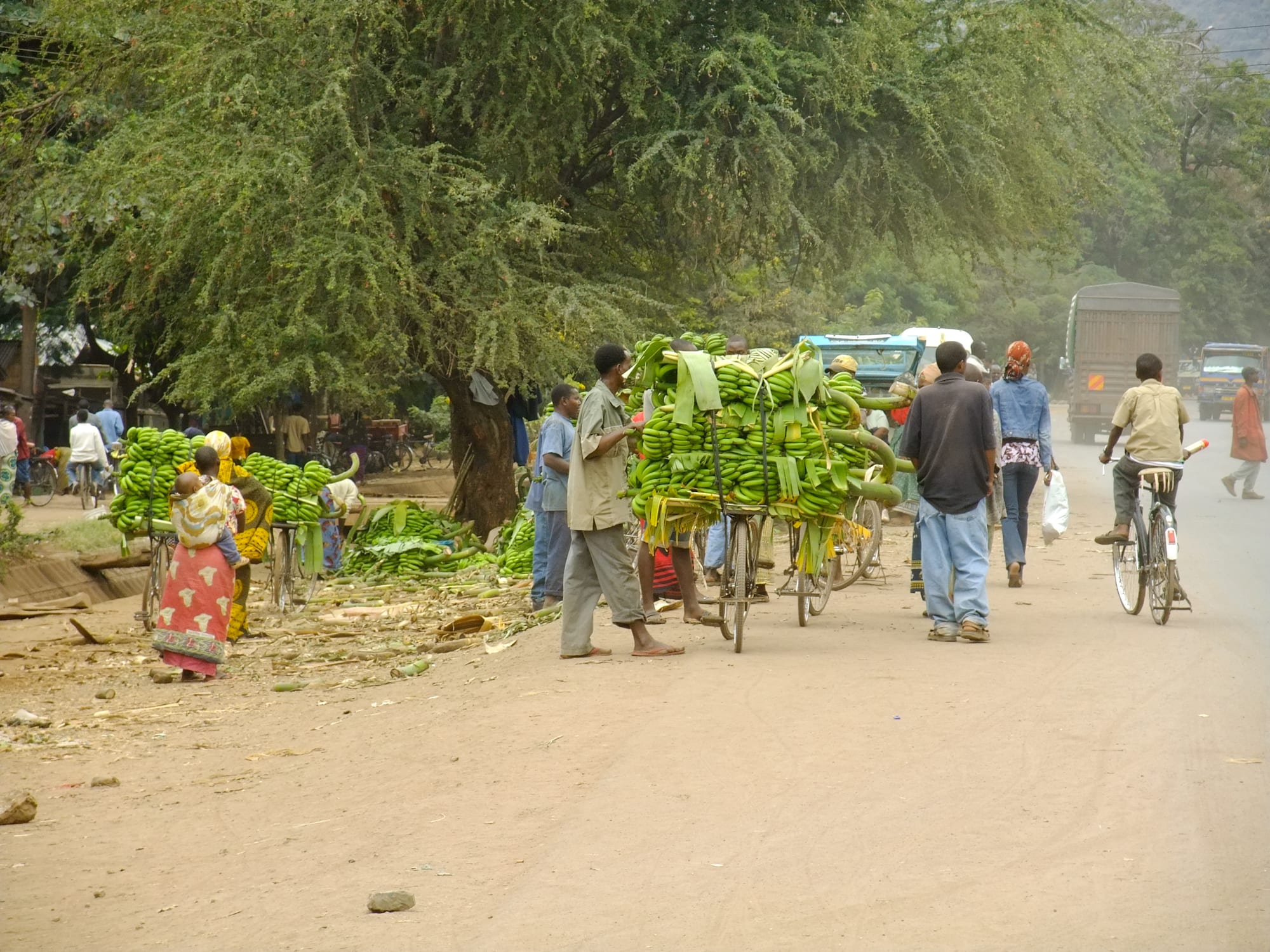
Bunches of green bananas loaded on bicycles and piled under trees beside a dusty road, with people walking past

Arusha, Kilimanjaro & the Northern Safari Circuit, Tanzania

Mto wa Mbu

Bananas brought in by bicycle and sold beside the main road through Mto wa Mbu. (lecucurbitacee / Wikimedia Commons · CC BY 2.0)

A market village in northern Tanzania at the foot of the Rift Valley escarpment, on the road from Arusha towards Ngorongoro. Its name means 'river of mosquitoes' in Swahili, and streams off the wall water banana groves, rice plots and vegetable gardens. Migrants from many parts of the country have settled here, and the gate of Lake Manyara National Park stands at its edge.

Neighbourhoods

  • The main road through the village
    • First-time visitors
    • Markets
    • Close to public transport

    The tarmac road from Arusha to Karatu runs straight through the middle of the village, lined with shops, bus and minibus stops, small restaurants, craft stalls and fruit sellers. It is busiest in the early morning and again when safari vehicles come down off the escarpment in the afternoon.

    Open in Maps
  • The banana groves and irrigated plots
    • Local life
    • Countryside walks

    Behind the road the land is green and densely worked, with furrows carrying water from the escarpment through banana gardens, rice paddies, maize and vegetable plots. Narrow paths run between the smallholdings and past the homes of families who came here from many parts of Tanzania.

    Open in Maps
  • Towards the park gate and the lake
    • Wildlife
    • Quiet and residential

    East and south of the village the ground falls away towards Lake Manyara, with the national park entrance a short distance from the last houses. Lodges, camps and campsites stand among trees along this edge, quieter than the road and within sight of the Rift wall.

    Open in Maps
  • The foot of the escarpment
    • Views
    • Photography

    The road west climbs the Rift Valley wall in tight bends towards Karatu, and the slope above the village gives wide views over the flat, irrigated fields and the pale sheet of the lake beyond. Springs emerging at the base of the wall are what made settlement here possible.

    Open in Maps

Things to do

In the village

  • The banana marketmarket

    Bunches of green and ripe bananas of many varieties are brought in by bicycle and handcart and traded beside the road, the produce the village is best known for.

    Open in Maps
  • The Maasai marketmarket

    An open craft market of stalls selling beadwork, carvings, paintings and cloth to passing safari traffic, named for the Maasai who trade in the village.

    Open in Maps
  • The irrigated farms and rice paddiesattraction

    Furrows fed by escarpment streams water banana gardens, rice, maize and vegetables on the flat ground behind the village, worked by smallholders and walked with local guides.

    Open in Maps
  • The Rift Valley escarpment viewpointviewpoint

    The bends of the road climbing the Rift wall west of the village look back over the irrigated plain and towards Lake Manyara.

    Open in Maps

Lake Manyara

  • Lake Manyara National Parkpark

    A narrow park between the Rift wall and the lake, given national park status in 1960, with groundwater forest, a hippo pool, elephants, baboons and lions; its main gate is at the edge of the village.

    Open in Maps
  • Lake Manyaraattraction

    A shallow alkaline lake at the foot of the escarpment whose level rises and falls with the rains, drawing flamingos and pelicans when the water is high.

    Open in Maps

Short trips from the village

  • Tarangire National Parkpark

    A dry-season refuge on the Tarangire River south-east of the village, known for large herds of elephants among old baobabs.

    Open in Maps
  • Ngorongoro Conservation Areapark

    The protected highlands west of the escarpment, a UNESCO World Heritage Site where Maasai herding and wildlife share the land and the crater floor holds dense concentrations of game.

    Open in Maps
  • Karatuneighborhood

    The farming town at the top of the escarpment road, the usual overnight stop for the crater, set among wheat, maize and coffee fields.

    Open in Maps

Seasonal events

  • Nane Nane farmers' day8 August

    The national agricultural day, marked in a district that lives by irrigation farming with shows of crops, seed and livestock.

  • Harvest in the irrigated plotsthe drier months from about June

    The weeks when rice and other crops are cut and threshed behind the village, and grain is spread to dry beside the houses and the road.

  • Dry-season safari peakJune to October

    The months when safari traffic through the village is heaviest, the market stalls busiest and the park gate at its fullest.

Eat and drink

Long-standing places and food districts in Mto wa Mbu. Hours, ratings and directions come from your maps app, always current.

Village markets and food stalls

  • The village marketmarket

    Bananas, rice, vegetables, beans and fruit from the irrigated plots around the village, with cooked food, grilled maize and chapati sold at the edges.

    Open in Maps
  • Roadside local restaurantsneighborhood

    Small places along the main road serving ugali, rice, beans, greens and stew to drivers, traders and guides, the cheapest and most ordinary food in the village.

    Open in Maps
  • Nyama choma grillsneighborhood

    Charcoal grills where goat and beef are roasted, chopped on a board and eaten with kachumbari, the tomato-and-onion relish, and salt.

    Open in Maps

Local specialities

  • Banana dishesneighborhood

    Green bananas cooked in stews, roasted over charcoal at the roadside, and fermented into banana beer are the local signature, drawn from the varieties grown in the groves behind the village.

    Open in Maps

Experience Mto wa Mbu

History

Mto wa Mbu is a young settlement by the standards of the country around it. The flat ground at the foot of the Rift Valley wall was fever country, its streams and swamps giving the place the Swahili name that means river of mosquitoes, and it was used for grazing rather than permanent homes. Maasai herders moved cattle across the plain, and the Iraqw farmed the highlands above.

Settlement came with water control and with the road. Furrows were dug to carry the springs and streams that emerge at the base of the escarpment out across the plain, turning swamp and dry bush into irrigated plots, and migration brought farmers to take them up. Families arrived from many parts of the country, and the village became known for the number of languages spoken in it, with Swahili the language everyone shares.

The road was the second maker of the place. The game reserve at the village's edge became Lake Manyara National Park in 1960, and the highway from Arusha towards Ngorongoro and the Serengeti runs through the middle of the settlement, so that almost every vehicle on the northern safari circuit passes its shops. Craft stalls, guesthouses, campsites and guiding work grew up around that traffic. The village today lives on two things at once — the water from the escarpment that feeds its farms, and the road that carries visitors past its door.

Culture & Customs

The village is known in Tanzania for its mixture. Migration from many regions has put people of very different backgrounds on neighbouring plots, and the number of languages heard here is often given as a point of local pride, with Swahili serving as the common tongue in the market, the school and the street. Maasai from the surrounding rangelands come in to trade and to sell beadwork, and the Iraqw and Datooga of the highlands above are part of the same weekly economy.

That mixture shows in how the place works. Farming practice borrowed from several parts of the country sits side by side in the irrigated plots — bananas grown as they are on the Kilimanjaro slopes, rice as in the lake regions, maize and vegetables everywhere — and cooking traditions have travelled with the families who brought them. Craft workshops turn out carvings and paintings for the safari trade, much of it made by artisans who themselves came from elsewhere.

Manners are those of northern Tanzania generally: greetings before business, respect for elders, modest dress and a patient pace. The craft market involves steady, good-humoured bargaining, and guided walks through the farms are a long-established way for households to earn from the traffic without leaving the land. Churches and mosques both serve the village, reflecting the range of places its people came from.

Daily Life

Some 11,400 people lived in the Mto wa Mbu ward at the 2012 census, a number that has grown quickly with the irrigation and the road. Most households farm: bananas of many varieties, rice in the paddies, maize, beans, tomatoes and other vegetables, with milk and meat from cattle and goats. Water rights in the furrows are managed collectively and matter more here than almost anything else.

The second income is the safari circuit. Guides for farm and village walks, drivers, cooks, campsite and lodge staff, craft traders and stallholders all depend on the vehicles coming down the escarpment, and the collapse of travel in 2020 was felt sharply. Small shops, workshops, bars and guesthouses line the main road, and buses and minibuses call through the day on their way between Arusha and Karatu.

The day starts early, with produce moving to the roadside by bicycle and handcart before the heat, and slows in the middle of the afternoon. Current issues are the pressure of a growing population on irrigated land and on the water itself, crop raiding and danger from elephants and buffalo moving between the park and the farms, malaria in this low, wet ground, and the thin and uneven spread of tourist money through the village.

Food

Bananas define the local table. Dozens of varieties grow in the groves behind the village, some for eating ripe, some for roasting over charcoal at the roadside, and green cooking bananas for stews — mtori, the thick stew of mashed green bananas and meat eaten across the Kilimanjaro region, is familiar here, as is plain ndizi nyama, bananas simmered with beef. Banana beer, fermented at home, is the everyday drink of many households.

Rice from the village's own paddies is the other staple, cooked plain or as pilau spiced with cumin, cardamom and cinnamon for celebrations. Ugali, the stiff maize porridge, is eaten with beans, greens such as mchicha, and stews of fish or meat. Chapati and mandazi, the lightly sweet fried dough, are sold in the mornings, and chai heavy with sugar accompanies almost everything.

Nyama choma — goat or beef roasted over charcoal, chopped on a board and served with kachumbari, a relish of tomato, onion and chilli — is the sociable meal at the grills along the road. The market sells the produce of the irrigated plots at its plainest: tomatoes, onions, greens, mangoes and papaya in season, and groundnuts and dried fish brought in by bus from further away.

Planning tools

Budget

The village itself is one of the cheapest stops on the northern circuit, with guesthouses, market food and local buses costing very little. The money goes on the parks: entry fees for Lake Manyara and Tarangire are charged per person per day, a 4x4 with a driver-guide is needed for game drives, and the camps and lodges around the village are priced for safari travellers.

Daily Budget Midrange
USD 260–680 per day on a guided safari (vehicle, guide, park fees, lodge or tented camp)
Daily Budget Shoestring
USD 30–60 (guesthouse, market and roadside food, buses and shared minibuses)

Check which park fees a safari quote includes, and note that a walk through the farms and markets with a local guide costs a fraction of a game drive.

Best Time to Visit

June to October is the dry season and the peak for game viewing in Lake Manyara and Tarangire, when animals gather near water. January to March is warm and drier between the rains. The long rains of April and May bring green fields, low prices, a fuller lake and muddy side roads.

Suggested Number of Days

Most people pass through in a single day, often with a night at the edge of the village. Two or three days allow for the surrounding parks and time in the farms and markets. Weather and the state of the side roads change how much fits in.

First Visit
1 day
With Surroundings
2–3 days

Transportation

Nearly all visitors arrive in a safari vehicle with a driver-guide that stays with them. Otherwise buses and shared minibuses on the Arusha–Karatu road stop in the village through the day, and motorcycle taxis and bajaji cover short distances to the farms, the lodges and the park gate. Game drives in the parks require a 4x4.

Walking tours of the farms and markets are arranged locally with guides; agree what is included before setting off, and keep to the marked paths between smallholdings.

Airport & Station Connections

The village lies on the tarmac road from Arusha to the Ngorongoro gate, some 112 km and roughly two hours' drive from Arusha and about half an hour below Karatu at the top of the escarpment. Kilimanjaro International Airport is the nearest international gateway, some four hours away by road, and light aircraft serve the airstrip at Lake Manyara nearby. Buses between Arusha and Karatu or Mwanza run through daily.

Walkability

The village is small and flat, and its shops, market and stalls are strung along a few hundred metres of the main road, easily covered on foot. The farms and paddies behind are walked on narrow paths, usually with a local guide. The main road carries fast lorry and safari traffic with no pavement, and the ground is dusty in the dry months and muddy in the rains.

Safety

The village is used to visitors and generally calm. The main risks are the highway itself, with heavy through traffic and no footpaths, persistent selling and touting around the craft stalls, petty theft at the bus stops, and wild animals, which move between the park and the farmland; elephants and buffalo are a real hazard after dark. This is low, warm country, so malaria precautions matter here more than on the highlands above.

Climb with a licensed operator and ascend slowly, stay in the vehicle unless a guide says otherwise, and use taxis at night. Take malaria precautions, walk the main road with care, and do not walk between lodges and the village after dark. Check current official travel advice before travelling.

Climate

Warm Rift Valley floor climate at around 1,000 metres, hotter than Karatu and the highlands above the escarpment. The long rains fall from roughly March to May and shorter rains around November, when the streams off the wall run strongly. Southern-hemisphere summer falls in December to February.

Summer
December to March is hot, with days often around 30–32°C and afternoon storms in the wetter weeks
Winter
June to August is dry and a little cooler, with days near 27–29°C and comfortable nights around 15°C

Local Customs

Greetings come before business, and shikamoo is the respectful greeting to an elder. The village is unusually mixed, with families from many parts of Tanzania, and Swahili is the common language between them. Dress is modest. Tipping a driver-guide, a walking guide and lodge staff at the end of a trip is customary and forms a real part of their income.

Ask before photographing people, homes or market stalls, expect firm but good-humoured bargaining at the craft stalls, and treat visits to Maasai homesteads as arranged, paid visits made with respect.

Common Payment Methods

The currency is the Tanzanian shilling, used for the market, shops, stalls and buses. US dollars are standard for park fees, safaris and lodges, and notes should be recent and undamaged. Cash is essential in the village; cards are accepted at some lodges and almost nowhere else, and the nearest reliable ATMs are in Karatu or Arusha.