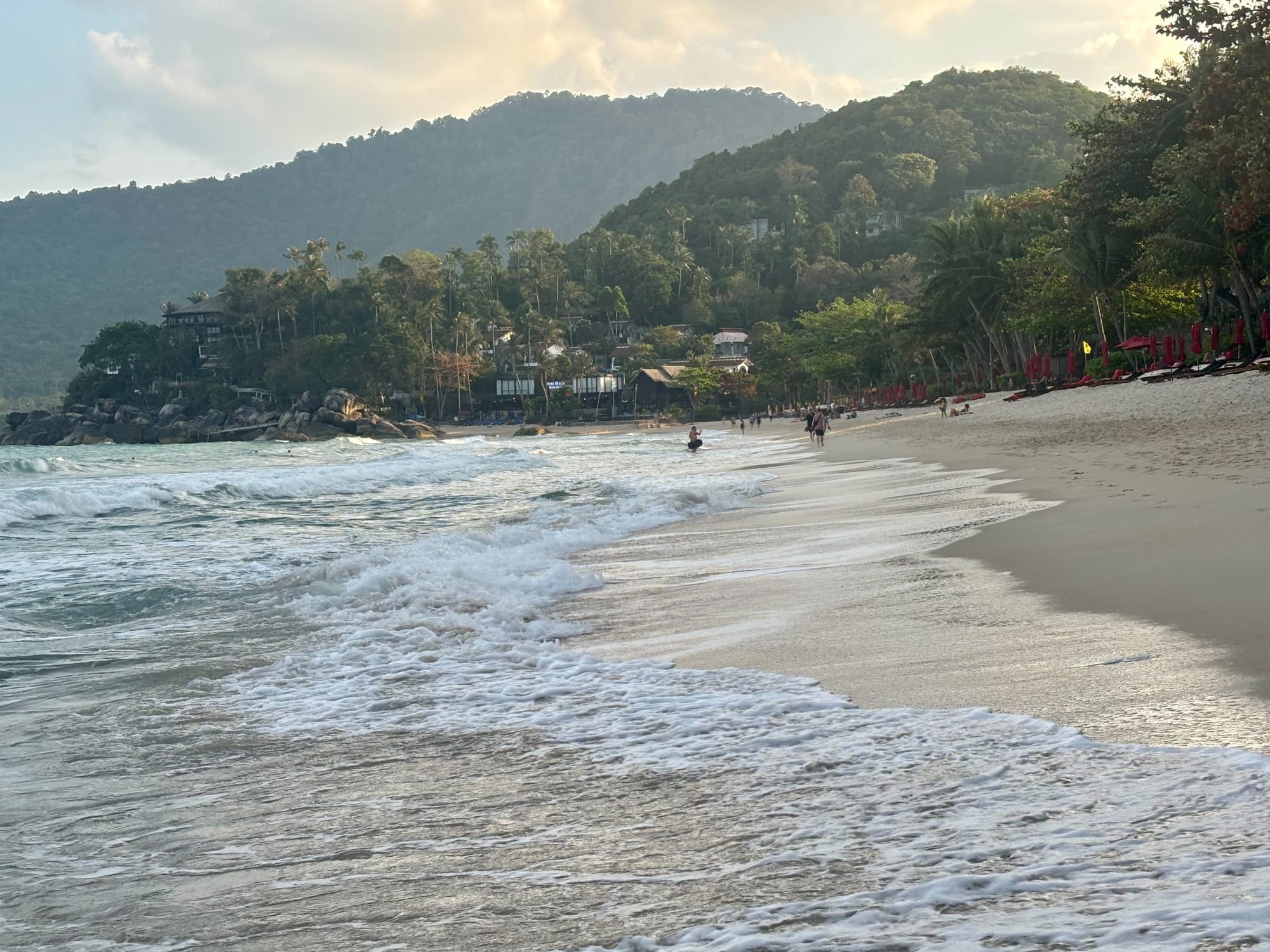
Surf washing onto a wide sand beach backed by palms, low wooden buildings and steep forested hills in late afternoon light

Koh Samui, the Gulf Coast & the Deep South, Thailand

Ko Pha-ngan

The beach at Thong Nai Pan on the north-east coast of Ko Pha-ngan. (kallerna / Wikimedia Commons · CC BY-SA 4.0)

An island in the Gulf of Thailand north of Ko Samui, in Surat Thani province, with a forested and largely roadless interior, a ring of bays and a small resident population of fishing and coconut-farming families. Known worldwide for the full moon gatherings at Hat Rin, it also holds quiet northern beaches, waterfalls and a long-established wellness and retreat scene.

Neighbourhoods

  • Thong Sala
    • Close to public transport
    • Markets
    • Local life

    The island's main town and ferry port on the west coast, with banks, supermarkets, repair shops and the night market where most residents shop and eat. Few visitors sleep here, but almost everyone passes through it.

    Open in Maps
  • Hat Rin
    • Nightlife
    • First-time visitors
    • Beaches

    The small peninsula at the southern tip, with a sunrise beach on one side and a sunset beach on the other, joined by a lane of bars, tattoo shops, guesthouses and food stalls. It is the site of the full moon gatherings and is quiet between them.

    Open in Maps
  • The south coast at Ban Tai and Ban Khai
    • Beaches
    • Quiet and residential
    • Close to the boats

    A long, shallow strip of beach between Thong Sala and Hat Rin, with bungalows, yoga schools, cafés and a string of small villages. It is flat, easy to move around and within reach of both the port and the party beach.

    Open in Maps
  • The west coast and Sri Thanu
    • Quiet and residential
    • Sunsets
    • Wellness

    Beaches and low headlands facing the sunset, with a large long-stay community, vegetarian cafés, yoga and meditation centres and a lagoon behind the shore. Quieter and more residential than the south.

    Open in Maps
  • The northern bays
    • Beaches
    • Quiet and residential
    • Swimming

    Hat Khuat, Hat Salad, Mae Haad and the bays either side of them, backed by steep forest and reached by rough roads or boat. The water is clear and the beaches small, with simple resorts and little at night.

    Open in Maps
  • Thong Nai Pan
    • Beaches
    • Families
    • Quiet and residential

    Two adjoining bays in the north-east, reached by a steep road across the island, with some of the island's better sand and a mixture of bungalows and larger resorts. The village behind the beach is small and self-contained.

    Open in Maps

Things to do

Beaches and bays

  • Hat Rin Nokbeach

    The larger of Hat Rin's two beaches, the sunrise beach on the north side of the peninsula at the island's southern tip, a curve of white sand backed by bars and the site of the monthly Full Moon Party.

    Open in Maps
  • Hat Khuatbeach

    Known in English as Bottle Beach, for the shape of its sheltered cove, a small northern bay enclosed by hills; a rough track leads there, but it is easiest to reach by boat.

    Open in Maps
  • Hat Saladbeach

    A short north-western beach with coral close to shore, a sheltered swimming area and a handful of low-key resorts.

    Open in Maps
  • Mae Haad and Ko Mabeach

    A north-western bay where a sandbar runs out at low tide to the islet of Ko Ma, with snorkelling on the reef alongside it.

    Open in Maps
  • Thong Nai Pan Yai and Noibeach

    Twin bays on the north-east coast separated by a headland, with clear water, a small village and steep forest behind.

    Open in Maps

Inland and nature

  • Than Sadet waterfallattraction

    A river of falls and rock pools running 2.5 kilometres to the east coast. Rama V first came in 1888 and returned many times, and his initials are carved on a rock near the river mouth; the national park around it was created in 2018.

    Open in Maps
  • Phaeng waterfallattraction

    A waterfall in the forested centre of the island, inside the national park, with a walking trail continuing uphill to a viewpoint over the forest and the coast.

    Open in Maps
  • Khao Raviewpoint

    The highest point of the island and of its national park, at 635 metres, climbed on a steep forest path to a summit view over the bays and across to Ko Samui.

    Open in Maps
  • Wat Phu Khao Noilandmark

    A hillside temple near Thong Sala, long established and much visited, with a chedi, a resident monastic community and a view over the west coast.

    Open in Maps

On the water

  • Snorkelling and dive tripsattraction

    Boats run from Chaloklum and Thong Sala to reefs around Ko Ma, Sail Rock and the north coast; several dive schools are based on the island.

    Open in Maps
  • Chaloklum fishing harbourattraction

    A working fishing village on the north coast, with boats, drying squid and seafood restaurants along the shore.

    Open in Maps

Markets and nights out

  • Thong Sala night marketmarket

    The island's main evening food market, with grilled seafood, curries, noodles, sweets and produce, busy with residents as well as visitors.

    Open in Maps
  • Hat Rin's barsattraction

    The lane and beachfront at Hat Rin hold most of the island's nightlife, from small bars to sound systems on the sand that fill for the monthly parties.

    Open in Maps

Short trips from the island

  • Mu Ko Ang Thong National Parkpark

    A national park of 42 forested limestone islands with sea caves, inland saltwater lakes and cliff viewpoints, visited on day trips by boat.

    Open in Maps
  • Ko Samuiattraction

    The larger neighbouring island to the south, linked by frequent ferries and speedboats, with the region's airport, hospitals, shopping and its own long beaches.

    Open in Maps
  • Ko Taoattraction

    The smaller island to the north, reached by boat, with sheltered bays, coral reefs and a large diving industry.

    Open in Maps

Seasonal events

  • Full Moon Partymonthly, on or near the full moon

    An all-night beach gathering on Hat Rin's sunrise beach that started in 1985 and has been described as the largest beach rave in the world, with sound systems along the sand and extra boats from Samui.

  • Half Moon and other monthly partiesmonthly, around the half moon

    Smaller organised events held inland and on other beaches between the full moons, part of the island's monthly party calendar.

  • SongkranApril

    Thai new year, marked with temple merit-making, water pouring over Buddha images and water fights in Thong Sala and the villages.

  • Loi KrathongNovember

    Candlelit floats of banana leaf and flowers are set on the sea on the full moon of the twelfth lunar month.

Eat and drink

Long-standing places and food districts in Ko Pha-ngan. Hours, ratings and directions come from your maps app, always current.

Ko Pha-ngan classics

  • Seafood at Chaloklumneighborhood

    The north-coast fishing village sells squid, prawns, crab and whole fish landed by its own boats, grilled over charcoal at simple restaurants facing the water.

    Open in Maps
  • Southern curries and khanom jeenrestaurant

    Island kitchens serve the southern repertoire — sour yellow fish curry, dry-fried kua kling and fresh rice noodles eaten with curry and raw vegetables.

    Open in Maps

Markets and food streets

  • Thong Sala night marketmarket

    Stalls of grilled skewers, som tam, seafood, roti and coconut sweets in the port town, the cheapest and busiest eating on the island.

    Open in Maps
  • Sri Thanu's vegetarian cafésneighborhood

    The west coast's long-stay and wellness community supports a cluster of vegetarian and vegan kitchens, juice bars and bakeries unusual for an island this size.

    Open in Maps
  • Hat Rin's food laneneighborhood

    Cheap Thai kitchens, sandwich and pancake stalls and late-night food carts serving the beach crowd at the southern tip.

    Open in Maps

Experience Ko Pha-ngan

History

Ko Pha-ngan was settled long before tourism, by fishing families and by farmers who planted coconut on the flat ground behind the bays and worked the forest inland. Its lasting royal association comes from Than Sadet, a stream on the east coast: Chulalongkorn, Rama V, first came to its waterfall in 1888 and returned as many as fourteen times over the following twenty-one years, and his initials are cut into a rock near the river mouth. Later monarchs came too, and the stream gave its name to Than Sadet–Ko Pha-ngan National Park, established in 2018, which covers a good part of the island.

For most of the twentieth century the island was a quiet corner of Surat Thani province, reached by boat from Samui or the mainland, with a coconut and fishing economy and villages linked by tracks rather than roads. Travellers who found Samui too busy began crossing, and Hat Rin grew into a backpacker destination in the 1980s, with simple bungalows along the southern shore.

The change that made the island famous came in 1985, when a beach gathering on Hat Rin's sunrise beach on the night of the full moon grew into a monthly event advertised worldwide, serviced by extra ferries from Samui and policed heavily for drugs. Around it grew a second, quieter industry: yoga schools, meditation and detox retreats, and a long-stay community on the west coast. Roads were paved, piers rebuilt and larger resorts opened in the northern bays, and the island now carries both reputations at once, along with the strain that visitor numbers put on its water, waste and roads.

Culture & Customs

The island is southern Thai and Buddhist, and outside the resort strips life runs on the temple calendar: merit-making on holy days, morning alms rounds, temple fairs and ordinations. Wat Phu Khao Noi above Thong Sala is one of its long-standing temples, and several monasteries run meditation courses that outsiders may join, a practice with much longer roots here than the commercial retreat business.

Two other cultures sit alongside it. The first is the party scene at Hat Rin, with its monthly cycle of full, half and black moon nights, fire shows, body paint and buckets of drink, which has shaped how much of the world pictures the island. The second is the wellness and long-stay community on the west coast around Sri Thanu, where yoga, ecstatic dance, fasting programmes and vegetarian cafés support a floating international population, some of whom stay for months.

Residents tolerate all this but do not take part in it, and the gap between the village and the beach is wide. Ordinary Thai courtesies matter more than visitors often assume: covered shoulders in temples and shops, shoes off indoors, no shouting or lost tempers in public, and restraint with alcohol away from the party areas. Islanders are also increasingly vocal about litter, noise and the behaviour of visitors in the villages.

Daily Life

Ko Pha-ngan's resident population is small, spread among Thong Sala, Chaloklum, Ban Tai, Ban Khai and the smaller beach villages, with many more seasonal workers from the mainland and from Myanmar during the high months. Thong Sala holds the hospital, the schools, the banks, the fresh market and the government offices, and the island's working day begins there when the first ferries dock.

Tourism pays for nearly everything, through bungalows, restaurants, transport, diving and the retreat businesses, and the rhythm follows the monthly party and the yearly season. Coconut farming continues in the interior and fishing boats work from Chaloklum and the northern bays, but both employ far fewer people than they did. In the wet months trade falls away, staff go home to the mainland and parts of the coast close.

Daily life is shaped by geography: a mountainous, forested centre with no road across much of it, so villages face the sea rather than each other. Electricity and water supply are stretched in high season, rubbish removal is a recurring problem on an island without room for it, and road accidents on the steep gradients fill the island's small hospital. Land prices and new resort building in the northern bays are the other live local arguments.

Food

The island eats southern Thai food, hot with fresh turmeric and shrimp paste. Kaeng som, a sour yellow curry of fish with vegetables, and kua kling, minced meat dry-fried with a chilli and turmeric paste, are standards in the village kitchens, eaten with rice and a plate of raw vegetables and herbs. Khanom jeen, soft fresh rice noodles served with curry and a basket of greens, is a common breakfast, as is jok, rice porridge, at the Thong Sala market.

Seafood comes off the boats at Chaloklum and the southern piers: squid, prawns, blue swimming crab, snapper and mackerel, grilled over charcoal with a sharp chilli, lime and garlic dip, or cooked as tom yam or a steamed fish with lime. Coconut, the island's old crop, runs through the curries and the sweets, from coconut milk custards to sticky rice grilled in banana leaf.

The visitor economy has added its own layers. Hat Rin has cheap Thai kitchens alongside pancake and sandwich stalls for the party crowd, while Sri Thanu and the west coast have an unusual concentration of vegetarian and vegan cafés, juice and smoothie bars and bakeries serving the retreat community. Thong Sala's night market, held most evenings, is where the two worlds meet and where the cheapest and most varied eating on the island is found.

Planning tools

Budget

Ko Pha-ngan is cheaper than Ko Samui, with simple bungalows on most beaches and night market food at mainland prices. Costs jump around the full moon, when rooms at Hat Rin are scarce and dearer and boats are crowded, and rise again in the December to February high season. Taxis on the island's steep roads are expensive for the distances involved.

Daily Budget Midrange
USD 90–210 (resort on Samui, restaurants, ferries, a dive or national park trip)
Daily Budget Shoestring
USD 25–45 (bungalow or hostel bed, night market food, shared songthaews)

Book a room several days ahead for the nights around a full moon, and expect a minimum-stay requirement at Hat Rin over that period.

Best Time to Visit

February to September is the drier half of the year on the Gulf side, with calm seas, clear water and reliable boats. October to December brings the northeast monsoon, with heavy rain, rough crossings and some businesses on the quieter beaches closing. The island is busiest around the monthly full moon and over the Christmas and New Year weeks.

Suggested Number of Days

Three or four days are enough for one part of the island. Longer stays are common here — the retreat and wellness scene draws people for weeks — and anyone timing a visit around the monthly party or adding the neighbouring islands needs a week or more.

First Visit
3–4 days
With Surroundings
5–7 days

Transportation

Songthaew pick-up trucks run from the Thong Sala pier to the main beaches on set routes, charging a fare per person that rises for the northern bays. Scooters are widely rented and widely crashed: several island roads climb very steeply, and the routes to Hat Rin, Thong Nai Pan and Bottle Beach are notorious. Longtail boats serve beaches that the roads reach badly.

Take a taxi or boat rather than a scooter on the steep northern and Hat Rin roads, and check that a rented bike has working brakes before setting off.

Airport & Station Connections

There is no airport. Ferries and speedboats reach Thong Sala from Ko Samui, Ko Tao and the mainland ports of Surat Thani and Chumphon; the town has three piers, the largest taking full-sized passenger craft and the others smaller passenger and dive boats. Most visitors fly into Samui or Surat Thani, or take the train or a bus to Surat Thani, and continue by boat. Extra sailings are added around the full moon, and crossings are cancelled in rough weather.

Walkability

Individual beaches and Thong Sala's grid are easy on foot, and Hat Rin is small enough to cross in ten minutes. The island as a whole is not walkable: bays are separated by forested hills and steep roads, distances run to many kilometres, and there is no lighting outside the villages.

Safety

The island is generally safe, but it has particular risks. Scooter accidents on its steep roads injure visitors every week, and the roads around Hat Rin are among the worst. At the monthly parties, drink spiking, theft, fights, broken glass on the sand and drownings after drinking are recurring problems, and drugs are sold openly but policed with severe penalties, including sting operations. Rip currents and jellyfish appear seasonally.

Ride only with a licence and a helmet, keep drinks in sight and never accept them from strangers, leave passports and cards at the hotel on party nights, do not swim after drinking, and avoid drugs entirely. Check current official travel advice before travelling.

Climate

Tropical and humid all year, mostly between 25 and 34°C, with the seasons set by the monsoons. Sheltered from the southwest monsoon, the island stays relatively dry through the middle of the year and takes its rain late.

Summer
hot and largely dry from February to September, around 28–34°C, with short heavy showers and calm seas
Winter
October to December is the wet season, with heavy rain, storms and rough crossings, around 24–30°C; January clears

Local Customs

Away from Hat Rin this is a conservative island of temple villages and fishing families. Swimwear belongs on the beach, shoulders and knees are covered at temples, shoes come off indoors, and public drunkenness outside the party areas is badly received. Monks collect alms in the morning and should not be touched by women. Tipping is not expected.

Cannabis was decriminalised in 2022, but rules tightened in 2025 classed the flower as a controlled herb and limited legal sales to medical use; other drugs carry long prison sentences, police enforcement is stepped up around the parties and there are officers in plain clothes.

Common Payment Methods

The currency is the Thai baht. ATMs are in Thong Sala, Hat Rin and the larger beach villages and charge a fixed fee per foreign withdrawal. Resorts, dive schools and larger restaurants take cards, often with a surcharge, while bungalows, songthaews, boats and market stalls are cash only; machines can run empty around a full moon weekend.