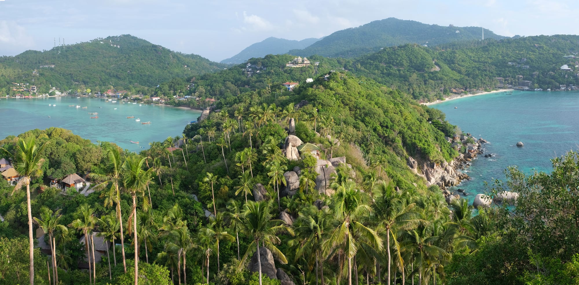
A palm-covered headland between two turquoise bays, with boats moored off a village on the left and forested hills beyond

Koh Samui, the Gulf Coast & the Deep South, Thailand

Ko Tao

The bays either side of the southern headland of Ko Tao, seen from the John-Suwan viewpoint. (kallerna / Wikimedia Commons · CC BY-SA 4.0)

A small granite island of about 21 square kilometres in the Gulf of Thailand, the northernmost of the three sister islands of the Chumphon Archipelago and a subdistrict of Ko Pha-ngan district in Surat Thani province. Once a coconut island and for fourteen years a political prison, it was settled permanently only in the mid-twentieth century and now lives almost entirely from scuba diving, with sheltered bays, shallow reefs and a great many dive schools.

Neighbourhoods

  • Mae Haad
    • Close to public transport
    • First-time visitors
    • Local life

    The island's port village, where the boats from the mainland and the other islands tie up. Its few streets hold the pharmacies, banks, dive shops, bakeries and offices that serve the whole island, and it is the easiest base for anyone without transport.

    Open in Maps
  • Sairee
    • Beaches
    • Nightlife
    • Best for food

    The long west-coast beach north of the pier, the island's main resort strip, with a sand-side path of bars and restaurants and a dense row of dive schools behind it. Sunsets and evening crowds are the draw; it is also the busiest and noisiest part of Ko Tao.

    Open in Maps
  • Chalok Baan Kao
    • Quiet and residential
    • Beaches
    • Swimming

    A rounded bay on the south coast with shallow water, a smaller cluster of resorts, restaurants and dive shops, and easier access to the southern viewpoints. Quieter than Sairee but still walkable in itself.

    Open in Maps
  • The east coast bays
    • Snorkelling
    • Quiet and residential
    • Views

    Tanote, Ao Leuk, Hin Wong and the smaller coves on the far side of the island, reached by steep roads or boat. Each has a handful of bungalows, clear water over boulders and coral, and almost nothing else.

    Open in Maps
  • The north and Mango Bay
    • Snorkelling
    • Quiet and residential

    The least built-up end of the island, where a rough track climbs to a coast of rocky headlands and small reef-fringed bays, most easily visited by longtail boat from Sairee.

    Open in Maps

Things to do

Diving and snorkelling

  • Koh Nang Yuanattraction

    Three small islands off the north-west coast joined by sandbars, with a snorkelling reef alongside and a climb to a boulder viewpoint over the bars.

    Open in Maps
  • Chumphon Pinnacleattraction

    A submerged pinnacle west of the island and the best known of Ko Tao's deeper dive sites, with a reputation among divers for whale sharks and bull sharks.

    Open in Maps
  • Shark Baybeach

    Hat Sai Daeng in the south-east, where blacktip reef sharks are often seen in the shallows by snorkellers from the beach.

    Open in Maps
  • Japanese Gardensattraction

    A shallow coral garden between Koh Nang Yuan and the main island, one of the standard first dives and an easy snorkelling stop.

    Open in Maps
  • Dive schools of Sairee and Mae Haadattraction

    Schools along both villages teach entry-level and professional certifications on the sheltered reefs, and dive training is the island's main business.

    Open in Maps

Beaches and bays

  • Sairee Beachbeach

    The most popular beach on the island, 1.7 kilometres of white sand on the west coast broken by a few large boulders, shallow and calm, with resorts and restaurants behind it.

    Open in Maps
  • Tanote Baybeach

    An east-coast bay of clear water and large granite boulders, with coral close to shore and a boulder that swimmers jump from.

    Open in Maps
  • Ao Leukbeach

    A small south-eastern bay with a steep shelf, good visibility and reef within swimming distance of the sand.

    Open in Maps
  • Freedom Beachbeach

    A short beach south of the pier, reached on foot around the headland or by a path from Chalok Baan Kao, with shallow water and a viewpoint above it.

    Open in Maps

Walks and viewpoints

  • John-Suwan Viewpointviewpoint

    A rocky headland at the southern tip reached by a steep path, looking down on the bays of Chalok Baan Kao and Thian Og on either side.

    Open in Maps
  • Mango Viewpointviewpoint

    A high point above the island's north-west, reached by a very steep track, with a view over Sairee and Koh Nang Yuan.

    Open in Maps
  • Two Viewviewpoint

    An inland viewpoint on the island's central ridge that looks out over both the east and west coasts.

    Open in Maps
  • The Jor Por Ror rocklandmark

    A boulder at Jor Por Ror Bay, next to Sairee Beach, carrying the royal monogram that Chulalongkorn left when he visited the island on 18 June 1899.

    Open in Maps

Short trips from the island

  • Sail Rockattraction

    A pinnacle, known in Thai as Hin Bai, rising just above the surface midway to Ko Pha-ngan, inside Than Sadet–Ko Pha-ngan National Park; whale sharks are sometimes seen there.

    Open in Maps
  • Ko Pha-nganattraction

    The larger island to the south, known for the full moon gatherings at Hat Rin, quiet northern bays and a forested interior.

    Open in Maps

Seasonal events

  • Whale shark seasonvaries from year to year

    Whale sharks are reported at Sail Rock and the island's pinnacles in some months of the year, and divers plan trips around the sightings.

  • SongkranApril

    Thai new year, marked with temple merit-making and water throwing along the Sairee and Mae Haad streets.

  • Loi KrathongNovember

    Small decorated floats are set on the sea on the full moon of the twelfth lunar month.

  • Reef clean-up daysthrough the year

    Dive schools and island associations run organised underwater and beach clean-ups, a long-standing part of the island's conservation work.

Eat and drink

Long-standing places and food districts in Ko Tao. Hours, ratings and directions come from your maps app, always current.

Ko Tao classics

  • Seafood at Mae Haad and Chalok Baan Kaoneighborhood

    Restaurants near the piers grill the day's squid, prawns and whole fish over charcoal, served with a chilli, lime and garlic dipping sauce.

    Open in Maps
  • Sairee's beachfront kitchensneighborhood

    A continuous run of Thai and international restaurants and bars along the sand path, the island's main place to eat and drink after a day's diving.

    Open in Maps

Everyday food

  • Mae Haad's Thai kitchens and bakeriesneighborhood

    Rice-and-curry shops, noodle stalls and bakeries in the port village, where dive staff and residents eat at island prices rather than beachfront ones.

    Open in Maps
  • Evening food stallsmarket

    Carts and stalls set up at dusk selling grilled skewers, som tam, pad thai, roti and fruit shakes near the pier and along the Sairee road.

    Open in Maps

Experience Ko Tao

History

Ko Tao was uninhabited for most of its history, visited by fishermen from the larger islands who sheltered in its bays and by turtles that gave the island its name, the turtle island; it is still a breeding ground for hawksbill and green turtles. Its first recorded royal visit came on 18 June 1899, when Chulalongkorn, Rama V, left his monogram on a huge boulder at Jor Por Ror Bay, beside Sairee Beach, where it can still be seen.

From 1933 the Thai government used the island as a political prison, a role it kept until 1947, when the prime minister, Khuang Abhaiwongse, obtained a royal pardon for all the prisoners held there. Settlers from the neighbouring islands then took up the empty island, planting coconut on the flat ground and fishing from the western bays; the first permanent community dates from that settlement, which is why Ko Tao's village life is younger than that of its neighbours.

Diving changed everything. The first small dive operations opened in the 1980s, when travellers arrived on fishing boats and stayed in wooden bungalows, and the island became one of Thailand's main places to learn to dive, with courses running year-round on its sheltered, shallow reefs and a little over twenty-five dive sites around it. Roads were cut, piers built and the west coast filled in. Success brought pressure: coral bleaching, sewage and waste, water shortages and building on steep slopes have all become island issues, and local associations, dive schools and conservation projects now run reef monitoring, mooring buoys and clean-ups, among them a turtle breeding programme started in 2004 by the Royal Thai Navy with the island's dive centres, which has returned hundreds of juvenile turtles to the water.

Culture & Customs

Ko Tao's identity is built around diving to an extent few places match. The working population is a mix of Thai families descended from the Pha-ngan settlers, Thai staff from the mainland, migrant workers from Myanmar, and a large rotating international community of instructors and divemasters, many of whom arrive as students and stay for a season or for years. Days are organised around boat departures, courses and exams, and the evening on Sairee is when everyone comes ashore.

Underneath that runs an ordinary southern Thai island life of temples, schools and village committees. Merit-making, ordinations and the Buddhist holy days continue as elsewhere in Surat Thani, and Thai is the working language away from the dive shops. Conservation has become part of local culture too: reef surveys, artificial reef projects, coral nurseries and organised clean-up days are widely supported, because the island's economy depends directly on the state of the water.

Visitors are expected to behave as they would on any Thai island — covered shoulders in temples, no swimwear in shops, shoes off indoors, restraint in public argument — and to follow diving etiquette on the reef. Islanders are used to a young international crowd but the community is small, and behaviour that would pass unnoticed in a city is remembered here.

Daily Life

Ko Tao's official population was recorded at under 1,400 in 2006, concentrated at Mae Haad, Sairee and Chalok Baan Kao, and the working number is far higher: some 3,000 to 5,000 Burmese workers staff the island's tourist businesses, alongside Thai staff from the mainland and long-stay visitors. The island is administratively a subdistrict of Ko Pha-ngan district, so much government business still means a boat trip.

Almost every job is connected to diving or to the visitors it brings: schools, boats, compressors and equipment shops, resorts, restaurants, transport, building work and the supply trade that keeps it all going. Fishing continues on a small scale and coconut groves remain in the interior, but neither supports many households now. The season runs from about January to September, and the island empties noticeably in the wet months, when many staff return to the mainland or travel.

Living on a small granite island brings practical constraints that shape the day. Fresh water is limited and often trucked or desalinated, electricity and internet depend on links to the mainland, waste must be shipped off, and everything from vegetables to cement arrives by boat. The main road is narrow and busy, the clinics are small and serious cases go by boat or helicopter to Ko Samui or Surat Thani.

Food

Ko Tao's cooking is southern Thai adapted to an island that imports most of its ingredients. Seafood is the exception and the strength: squid, prawns, crab and whole fish landed at Mae Haad or brought from Chumphon, grilled over charcoal and served with nam chim seafood, a sharp dip of chilli, garlic, lime and fish sauce, or steamed with lime and chilli.

Everyday eating follows the southern repertoire — kaeng som, a sour yellow fish curry, kua kling, minced meat dry-fried with turmeric and chilli, massaman and green curries with coconut milk, and khanom jeen rice noodles with a basket of raw vegetables. Quick meals are pad thai, fried rice, noodle soup and som tam from the stalls that set up at dusk near the pier and along the Sairee road, and roti with banana and condensed milk is the standard late-night sweet.

The international population has left its own mark, with bakeries, coffee roasters, pizza and burger kitchens, and vegetarian and vegan menus more common here than on most Thai islands, all concentrated along Sairee and in Mae Haad. Fresh coconut, fruit shakes and imported beer are the usual drinks on the sand, and prices rise the closer a table sits to the water.

Planning tools

Budget

Ko Tao is among the cheaper islands in the Gulf for rooms and food, partly because dive schools discount accommodation for students taking a course. Diving is the main expense: an entry-level certification or a set of fun dives will outweigh everything else on the bill. Everything is shipped in, so supermarket goods, imported drink and boat transfers cost more than on the mainland.

Daily Budget Midrange
USD 90–210 (resort on Samui, restaurants, ferries, a dive or national park trip)
Daily Budget Shoestring
USD 25–45 (fan bungalow or dorm, Thai kitchens and stalls, walking and shared taxis)

Ask whether a dive course includes a room, since many schools do, and budget separately for boat transfers and for the landing fee charged at Koh Nang Yuan.

Best Time to Visit

February to September gives the calmest seas, clearest water and most reliable boats, with the best underwater visibility generally in the middle of that period. October to December is the northeast monsoon, with heavy rain, rough crossings, cancelled sailings and some businesses closed; January is usually a clearing month.

Suggested Number of Days

Three or four days suit a visitor who is not diving. An entry-level certification course takes about four days including travel, and divers commonly stay a week or longer. Boat delays in unsettled weather are worth allowing for before an onward flight.

First Visit
3–4 days
With Surroundings
5–8 days

Transportation

The island has a single narrow road along the west coast and steep, partly unpaved tracks over the ridge to the eastern bays. Pick-up taxis meet the boats and run set routes at fixed prices, longtail boats serve beaches that the roads reach badly, and scooters and quad bikes are rented everywhere. The east-coast and viewpoint tracks are steep enough that many rented bikes cannot climb them.

Use a taxi or a longtail boat for the eastern bays and viewpoints rather than a scooter, and photograph any rented vehicle before taking it to avoid disputes over damage.

Airport & Station Connections

There is no airport. Catamarans run from Chumphon on the mainland in roughly one and a half to three hours depending on the boat, from Ko Pha-ngan in about one and a half to two hours and from Ko Samui in about two and a half, with slower day and overnight boats from Chumphon and Surat Thani. Most visitors fly to Chumphon, Surat Thani or Samui, or take the southern railway to Chumphon, and continue by boat. Crossings are rough or cancelled during the northeast monsoon.

Walkability

Mae Haad, Sairee and Chalok Baan Kao are each walkable, and the road between Mae Haad and Sairee takes about twenty minutes on foot along a narrow, busy street with little pavement. Anywhere else means transport: the interior is hilly, the eastern tracks steep and unlit, and viewpoint paths rough underfoot.

Safety

Ko Tao is a small island with low levels of ordinary crime, and the everyday risks are the practical ones: scooter and quad crashes on steep, sandy tracks are frequent and are the commonest reason visitors end up at the island's small clinics, and diving carries its own hazards, with the nearest recompression chamber not on the island.

Choose a dive school with clear safety standards and insurance that covers diving, avoid scooters on the steep eastern and viewpoint roads, wear shoes on coral-strewn shores, and keep valuables locked away. Check current official travel advice before travelling.

Climate

Tropical and humid throughout the year, generally between 25 and 33°C, with the seasons set by the monsoons rather than temperature. The island lies in the lee of the southwest monsoon and takes its heavy rain late in the year.

Summer
hot and mostly dry from February to September, around 28–33°C, with brief showers and calm, clear water
Winter
October to December brings the northeast monsoon, with heavy rain, big swells and disrupted boats, around 24–30°C

Local Customs

The island is small and conservative outside the dive strips. Swimwear stays on the beach, shoulders and knees are covered at the temples, shoes come off indoors, and voices stay calm in disagreements. Diving culture adds its own etiquette: nothing is taken from the reef, gloves are discouraged on many sites, and standing on or touching coral is treated as a serious offence. Tipping is not expected but boat crews and instructors often receive something at the end of a course.

Sun cream that damages coral is discouraged by many schools, and marine life, shells and coral must not be collected or bought.

Common Payment Methods

The currency is the Thai baht. ATMs cluster at Mae Haad and Sairee and charge a fixed fee per foreign withdrawal; they can run empty in high season or after a storm interrupts deliveries. Dive schools, resorts and larger restaurants take cards, usually with a surcharge, while taxis, stalls, boats and small bungalows are cash only.