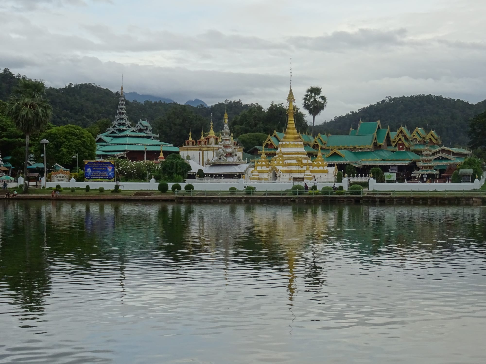
Gilded and green-roofed Burmese-style temples reflected in a calm lake, with forested hills and low cloud behind

Chiang Mai & the North, Thailand

Mae Hong Son

Wat Chong Kham and Wat Chong Klang on the shore of Chong Kham Lake in the centre of Mae Hong Son. (Christophe95 / Wikimedia Commons · CC BY-SA 4.0)

The capital of Thailand's north-western province, a small town in a narrow valley close to the Myanmar border, ringed by forested mountains that hold mist in the valley for much of the cool season. Founded in the 19th century as an elephant-catching camp, it is largely Shan in character, with Burmese-style temples reflected in a lake at its centre.

Neighbourhoods

  • Around Chong Kham Lake
    • First-time visitors
    • Historic district
    • Walks

    The heart of the town, where two Burmese-style temples stand on the southern shore of a small lake with a path around it. Guesthouses, cafés and the evening walking street are within a few minutes, and the lakeside is where people gather at dusk.

    Open in Maps
  • Khunlum Praphat Road
    • Close to public transport
    • Best for food
    • Shopping

    The main street running the length of the town, with the morning market, banks, the bus stop, travel agents and everyday shops. Plain and practical, and the place where local life is most visible.

    Open in Maps
  • The Doi Kong Mu hillside
    • Views
    • Quiet and residential

    The slope rising west of the town to the hilltop chedis, with a steep road, a few small hotels and a long view over the valley and the airstrip. Mornings here look down on cloud filling the basin.

    Open in Maps
  • The valley outskirts
    • Countryside
    • Quiet and residential
    • Families

    Villages and resorts spread along the Pai River and the highway north and south of the town, among rice fields, bamboo and forest, reached in ten to twenty minutes by road.

    Open in Maps

Things to do

Temples and the lake

  • Wat Chong Khamlandmark

    A Shan temple on the lake shore, among the oldest in the town, with a tiered wooden roof and a large seated Buddha in the Burmese manner.

    Open in Maps
  • Wat Chong Klanglandmark

    The neighbouring temple on the same lakeside, known for painted glass panels and carved wooden figures made by Burmese craftsmen.

    Open in Maps
  • Wat Phra That Doi Kong Mulandmark

    Twin white chedis on the hill above the town, raised in 1860 and 1872 by a Tai Yai merchant and by the first governor of Mae Hong Son, with the valley and the surrounding ranges spread out below.

    Open in Maps
  • Wat Hua Wianglandmark

    A temple near the morning market housing Phra Chao Phara La Khaeng, a revered bronze Buddha image cast in the Burmese style.

    Open in Maps
  • Chong Kham Lakepark

    The small lake at the town centre, circled by a walking path, gardens and food stalls, and lit around the temples after dark.

    Open in Maps

Mountains, caves and waterfalls

  • Namtok Mae Surin National Parkpark

    A park east of the town around Mae Surin, a single-tier waterfall about 180 metres high, with wild sunflower slopes that bloom in November.

    Open in Maps
  • Tham Pla–Namtok Pha Suea National Parkpark

    A park about eighteen kilometres north-west of the town, with a water-filled cave holding hundreds of revered mahseer barb and, separately, the Pha Suea waterfall.

    Open in Maps
  • Pang Mapha Districtattraction

    The limestone country north-east of the town, honeycombed with caves including the river cave at Tham Lod, and reached on the road towards Pai.

    Open in Maps

In the town

  • Mae Hong Son morning marketmarket

    An early market beside Khunlum Praphat Road where Shan, Karen and Thai traders sell vegetables, river fish, rice dishes and herbs before dawn.

    Open in Maps
  • Walking streetmarket

    The lakeside road closes to traffic in the evening during the tourist season for food and craft stalls run by local families.

    Open in Maps

Short trips

  • Ban Rak Thaiattraction

    A Yunnanese Chinese village of tea terraces beside a reservoir in the mountains north of the town, close to the Myanmar border.

    Open in Maps
  • Khun Yuamattraction

    A quiet district town south of Mae Hong Son with a museum on the Japanese army's retreat through the province at the end of the Second World War.

    Open in Maps

Seasonal events

  • Poy Sang LongLate dry season

    The Shan ordination festival, at its largest in Mae Hong Son, when boys are dressed as princes in jewels and make-up and carried through the town on adults' shoulders.

  • Chong PharaOctober

    At the end of Buddhist Lent, households and temples raise decorated bamboo and paper castles to welcome the Buddha's return from heaven, with lights and processions.

  • Loy KrathongNovember

    Floating lights are set on Chong Kham Lake, and lanterns are released as Yi Peng on the same full moon.

  • SongkranApril

    The Thai new year, kept with temple merit-making, sand chedis and water throwing along the main street.

Eat and drink

Long-standing places and food districts in Mae Hong Son. Hours, ratings and directions come from your maps app, always current.

Markets and food streets

  • Mae Hong Son morning marketmarket

    The best place to eat Shan food, with khao soi, thua nao soybean discs, fermented vegetables, rice noodles and steamed sweets sold from dawn.

    Open in Maps
  • Lakeside walking streetmarket

    Evening stalls around the lake sell grilled skewers, northern sausage, noodle dishes and sweets, with tables looking across the water to the temples.

    Open in Maps
  • Khunlum Praphat Roadneighborhood

    The main street holds most of the town's small restaurants and coffee shops, serving northern Thai, Shan and simple Chinese dishes.

    Open in Maps

Villages and tea

  • Ban Rak Thai tea housesneighborhood

    In the Yunnanese village by the border, families serve oolong grown on the slopes above alongside braised pork leg, black chicken soup and steamed buns.

    Open in Maps

Experience Mae Hong Son

History

Mae Hong Son began in the early 19th century, when a Chiang Mai official was sent west across the mountains to capture wild elephants and set up camps in the valleys of the Pai River. Shan families from across what is now the Myanmar border settled around them, and one of the camps grew into a village named after the elephant training ground. A Shan headman, later given the title Phraya Singhanat Racha, was appointed to govern the area, and the settlement became the seat of a small frontier state owing allegiance to Chiang Mai.

Teak drew the outside world in. British Burmese logging firms worked the forests in the later 19th century, and Burmese and Shan craftsmen built the town's temples, which is why they look across the border rather than towards Bangkok. Siam absorbed the northern states around 1900 and made Mae Hong Son a province, but distance kept it apart: for most of the 20th century it was reached by mule track or river, and the road link to Chiang Mai was completed only in the second half of the century.

The Second World War brought Japanese troops through the province on the route into Burma, and their retreat left traces recorded in a museum at Khun Yuam. Later decades brought refugees from conflict in Myanmar, camps along the border that have housed Karen families since the 1980s, opium and its replacement by royal project crops, and finally tourism, which grew with the airport and the loop road and now supports much of the town.

Culture & Customs

This is the most Shan place in Thailand. Tai Yai is spoken by many older residents, temple architecture uses the tiered pyatthat roofs and filigree metalwork of Burmese Buddhism, and the religious calendar follows Shan custom: Poy Sang Long in the hot season, when boys are dressed in silks and jewellery and carried through the streets before ordination, and Chong Phara in October, when decorated paper castles are raised at the end of Buddhist Lent to welcome the Buddha's return.

The province is also one of the most ethnically varied in the country. Karen communities are the largest group in the mountains, with Lisu, Lahu, Hmong and Padaung villages, Yunnanese Chinese settlements such as Ban Rak Thai founded by families who left China in the mid-20th century, and long-standing Thai administration over all of them. Questions of citizenship, land rights and the ethics of village tourism are live and discussed openly.

Everyday manners are quiet and formal, a little more reserved than in Chiang Mai. Crafts include Shan weaving, lacquer and silverwork, and the town's food, music and dress all show Burmese influence. The valley's isolation has shaped a strong local identity: residents talk of the province as a place apart, measured by the two long mountain roads that connect it to the rest of Thailand.

Daily Life

Only a few thousand people live in the town itself, and fewer than 300,000 in the province, most of them in farming villages spread through the mountains. Agriculture dominates: rice on the valley floors, maize and vegetables on the slopes, soybeans, garlic, coffee and tea. Government offices, schools and the provincial hospital provide salaried work in the town, and tourism supports guesthouses, restaurants, drivers and guides, although visitor numbers are small by northern Thai standards.

The day begins before dawn with the market and the alms round, the heat or the rain slows the afternoon, and the town is quiet by mid-evening apart from the lakeside. Many families keep ties to villages in the hills and to relatives across the border. Motorbikes and pick-ups are the way people move; long trips to Chiang Mai for hospital treatment or university are part of life.

The province's difficulties are structural. It is among the poorest in Thailand, with limited road access, and the burning season fills the basin with smoke that regularly gives Mae Hong Son some of the worst air quality in the country. The war in Myanmar across the border affects trade, sends people seeking safety into the province and keeps refugee camps in place after four decades. Landslides and flash floods close the mountain roads in heavy rain.

Food

Mae Hong Son eats Shan food, which is distinct from both northern Thai and central Thai cooking. Thua nao, soybeans fermented and dried into thin discs or ground into a paste, is the characteristic seasoning, used instead of fish sauce in many dishes. Khao soi here is closer to the Shan version than to the coconut curry of Chiang Mai: hand-sliced rice noodles topped with a tomato and meat sauce. Khanom jeen nam ngiao, rice noodles in a pork and tomato broth flavoured with dried kapok flowers, is a breakfast staple.

Other Shan dishes appear in the morning market: pounded rice cakes, sticky rice steamed in leaves, fermented vegetables, mild curries of pork with pickled greens and Burmese-influenced salads of tea leaf or beans dressed with garlic oil. Northern Thai cooking is here too, with sticky rice, nam phrik num and nam phrik ong chilli pastes, crisp pork rind and grilled sai ua sausage.

The mountains supply the rest. Yunnanese villages near the border cook black chicken soup, braised pork leg with mantou buns and Chinese pickles, and grow the oolong tea sold in the town; coffee from local plantations is roasted and served in small cafés around the lake. Cool-season produce — strawberries, cabbages, temperate vegetables from royal project farms — fills the market stalls from November, and wild honey and forest mushrooms appear in season.

Planning tools

Budget

Mae Hong Son is among the cheapest provincial capitals in Thailand for rooms and food, partly because few visitors reach it. Costs come from getting there — a flight, a long drive or a full day on winding buses — and from hiring a vehicle or a guide for the caves, waterfalls and border villages, which are widely spread through the mountains.

Daily Budget Midrange
USD 60–130 (valley resort, restaurants, a hire car or driver, a guided trek or village visit)
Daily Budget Shoestring
USD 20–35 (guesthouse, morning market and walking-street food, a shared scooter)

Rooms are scarce and prices rise during Poy Sang Long and the cool-season weekends, so book ahead then; the lake, the temples and the hill chedis cost nothing or very little.

Best Time to Visit

November to February, when the valley fills with mist at dawn, the days are mild and the hillsides above Khun Yuam turn yellow with wild sunflowers in November. March and April are hot and heavily smoky from forest and field burning, and air quality in this province is regularly among the worst in the country. The rains from June to October are green but bring landslides on the mountain roads.

Suggested Number of Days

Two days cover the town, the lake and the hilltop temple. Four to six allow the caves, waterfalls, border villages and Karen and Shan communities in the surrounding mountains, or the full loop road through Pai. Driving times are long for the distances involved.

First Visit
2 days
With Surroundings
4–6 days

Transportation

The town is small enough to walk, and songthaews, tuk-tuks and hired motorbikes serve the valley. Buses and minibuses run to Chiang Mai by two routes — the northern loop through Pai and the southern road through Mae Sariang — and both take the best part of a day. A hired car or a driver is the practical way to reach the border villages and national parks.

Mountain roads here are steep, narrow and frequently in cloud or smoke; allow far longer than the distance suggests, and avoid driving them after dark.

Airport & Station Connections

Mae Hong Son Airport sits on the edge of the town, a few minutes from the lake, with short flights from Chiang Mai. By road the northern route through Pai takes roughly seven to eight hours by bus from Chiang Mai and the southern route through Mae Sariang about the same; both are mountainous throughout. There is no railway in the province.

Walkability

The centre is very small and walkable: the lake, the temples, the market and the main street lie within a few hundred metres of one another on flat ground. The climb to the hilltop chedis is steep and takes about half an hour on foot, and everything outside the town needs a vehicle. Pavements are narrow and uneven in places.

Safety

Mae Hong Son is a quiet town with very little crime affecting visitors. The main risks are road accidents on mountain bends, smoke haze from February to April, trekking without a guide, and dengue and other mosquito-borne illness in the rainy season. Along the Myanmar border in this province, conflict and drug trafficking on the far side sometimes lead to closures of crossings and remote areas.

Wear a helmet, drive mountain roads slowly and in daylight, check the air-quality index in the burning season, trek with a licensed guide and follow local advice near the Myanmar border. Check current official travel advice before travelling.

Climate

A tropical climate shaped by mountains and by the deep valley, which traps cold air and fog overnight for much of the cool season and smoke in the hot months. Cool and dry from November to February, hot from March to May, and wet from June to October, when this is one of the rainiest parts of the north.

Summer
hot from March to May, often 35–40°C in the valley by afternoon with dense smoke haze; warm, humid and very wet from June to October
Winter
cool and dry from November to February, with days around 25–30°C, morning fog in the basin and nights that can approach 5°C

Local Customs

The town is largely Shan, or Tai Yai, and its temples follow Burmese forms and customs as much as Thai ones; shoulders and knees should be covered, shoes removed inside, and feet never pointed at a Buddha image. Karen, Lisu, Lahu and Hmong communities live in the surrounding mountains. Visits to their villages are best arranged through community guides, and several settlements associated with long-necked brass coils are tourist enterprises whose ethics are debated.

Ask before photographing people in villages, at markets and during ordination processions; dress modestly at temples; consider whether a village visit benefits the community. Cannabis was decriminalised in 2022 and rules tightened in 2025 classed the flower as a controlled herb, limiting legal sales to medical use.

Common Payment Methods

The currency is the Thai baht. Cash is essential: markets, songthaews, village shops, guesthouses and the border settlements rarely take cards, and ATMs outside the town are few. Machines on the main street charge a fixed fee for foreign cards. Draw enough before heading into the mountains, where there may be no machine for hours.