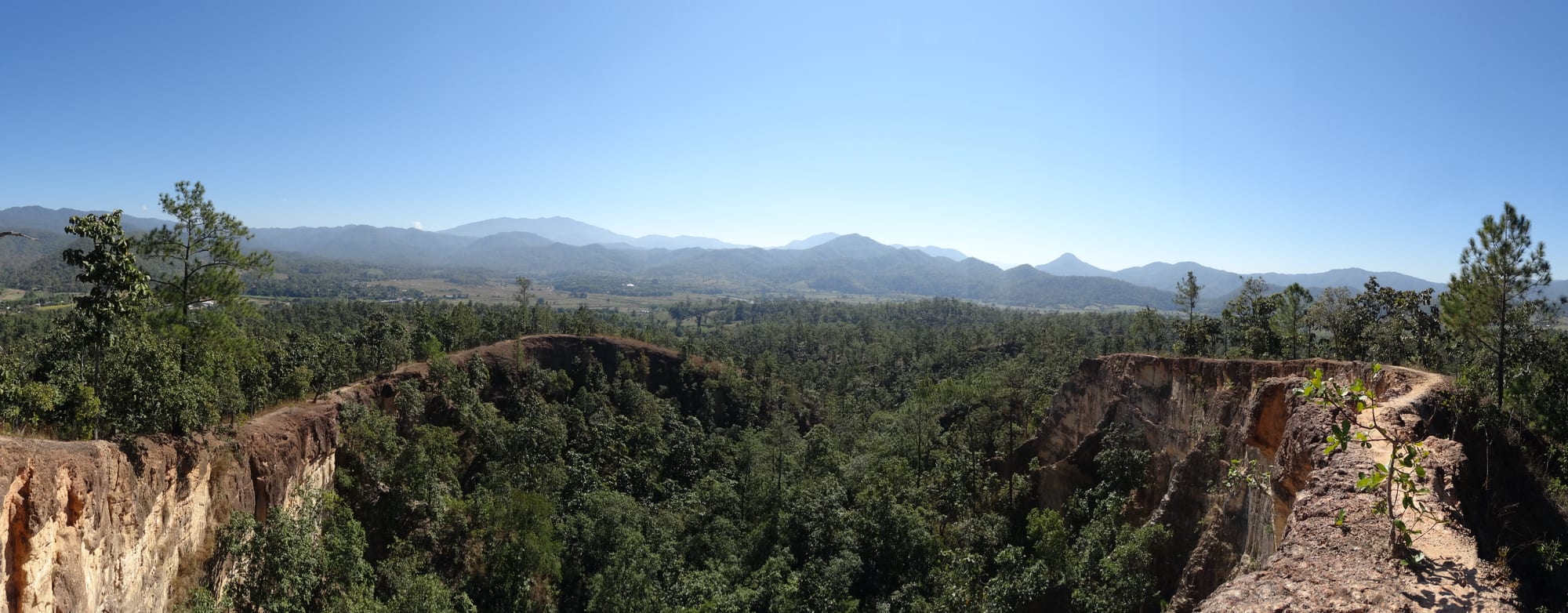
Eroded red earth ridges falling away into forest, with a flat green valley and blue mountain ranges beyond

Chiang Mai & the North, Thailand

Pai

The eroded ridges of Pai Canyon above the Pai valley in Mae Hong Son province. (Bernhard T / Wikimedia Commons · CC BY-SA 3.0)

A small town in a wide mountain valley in Mae Hong Son province, on the winding road west of Chiang Mai. Long a Shan farming settlement on the Pai River, it became a stop on the backpacker route in the 1990s and now lives largely on tourism, with hot springs, waterfalls, an eroded canyon and hill villages within a short ride of its single main street.

Neighbourhoods

  • The walking street and town centre
    • First-time visitors
    • Nightlife
    • Best for food

    Four or five streets around Chaisongkhram Road, which closes to traffic each evening for food carts, bars and craft stalls. Almost every guesthouse, bike hire shop and travel agent in Pai is within a few minutes' walk of it.

    Open in Maps
  • The east bank and Ban Mae Yen
    • Quiet and residential
    • Views
    • Walks

    Across the Pai River by footbridge, a scatter of bungalows, cafés and rice fields below the hill temple of Wat Phra That Mae Yen. Quieter than the centre and close enough to walk back in for the evening.

    Open in Maps
  • The northern valley
    • Countryside
    • Waterfalls
    • Quiet and residential

    The road out towards Mo Paeng and the Yunnanese village of Santichon, past bamboo bridges, fields and resorts spread along the valley floor. Most visitors reach it by scooter.

    Open in Maps
  • The southern approach and hot springs side
    • Close to transport
    • Families

    The Chiang Mai road south of town, where the bus station, the hot springs, the small airfield and a string of resorts and spas lie among farmland.

    Open in Maps

Things to do

The valley and its viewpoints

  • Pai Canyonviewpoint

    A ridge of deeply eroded red earth south of the town, with narrow paths along the crests and a long view over the valley at sunset.

    Open in Maps
  • Pai Riverattraction

    The river that gives the town its name, crossed by bamboo footbridges and used for rafting trips in the rainy season.

    Open in Maps
  • Wat Phra That Mae Yenlandmark

    A hill temple east of the river reached by a long flight of steps, with a large white Buddha looking back over the valley.

    Open in Maps
  • Huai Nam Dang National Parkpark

    A mountain park on the road towards Chiang Mai, known for the sea of cloud that fills its valleys on cool-season mornings.

    Open in Maps

Hot springs and waterfalls

  • Tha Pai Hot Springsattraction

    Thermal pools in forest south-east of the town, channelled into bathing pools of varying temperature within a small park.

    Open in Maps
  • Mo Paeng Waterfallattraction

    A series of falls and natural rock slides north-west of the town, busiest at the end of the rainy season when the water is high.

    Open in Maps

In the town

  • Pai Walking Streetmarket

    The main street closes each evening for food carts, craft sellers and musicians, the centre of the town's social life.

    Open in Maps
  • Memorial Bridgelandmark

    An iron bridge over the Pai River about ten kilometres south-east of the town, named the World War II Memorial Bridge though it was built after the war, now a roadside stop with stalls and a small market.

    Open in Maps

Short trips

  • Tham Lodattraction

    A large river cave in Pang Mapha district north-west of Pai, crossed by bamboo raft and known for its prehistoric teak coffins and evening flights of swiftlets.

    Open in Maps
  • Ban Santichonattraction

    A Yunnanese Chinese village a few kilometres from the town, founded by families who crossed from China, with tea houses and steamed buns.

    Open in Maps

Seasonal events

  • Loy KrathongNovember

    Floating offerings of banana leaf and candles are set on the Pai River, with lanterns released as Yi Peng on the same full moon.

  • SongkranApril

    The Thai new year, kept in the valley with temple merit-making, sand chedis and water throwing along the main street.

  • Poy Sang LongLate dry season

    Shan families dress boys as princes and carry them in procession before they are ordained as novice monks.

Eat and drink

Long-standing places and food districts in Pai. Hours, ratings and directions come from your maps app, always current.

Food streets and markets

  • Pai Walking Streetmarket

    Evening carts sell northern sausage, grilled skewers, rotis, noodles and sweets along Chaisongkhram Road, with tables set out in the side lanes.

    Open in Maps
  • Pai morning marketmarket

    The daily fresh market where the valley's rice, vegetables, chilli pastes and sticky rice are sold before the heat, with cooked-food stalls at the edges.

    Open in Maps
  • Ban Santichonneighborhood

    The Yunnanese village serves black chicken soup, braised pork leg, steamed buns and locally grown tea in simple open-sided restaurants.

    Open in Maps

Cafés and bars

  • Cafés along Chaisongkhram Roadneighborhood

    The town has an unusual number of small coffee shops for its size, roasting beans grown on the surrounding hills and serving breakfasts to long-stay visitors.

    Open in Maps
  • Riverside barsneighborhood

    Open-sided bamboo bars along the river and the lanes behind the walking street, where live music is common in the cool season.

    Open in Maps

Experience Pai

History

Pai is an old Shan settlement rather than a Thai one. The valley lies on the route between the Ping basin and the Salween country, and Tai Yai families farming rice along the river had a small walled town here under the principality of Mae Hong Son, which in turn owed allegiance to Chiang Mai and then Bangkok. Karen, Lisu and Lahu communities settled the surrounding hills, and Yunnanese Chinese families arrived in the 20th century, founding Santichon and other villages.

The Second World War brought the outside world briefly to the valley. Japanese forces moving towards Burma drove road-building through the valley, work abandoned in 1944; the iron bridge south-east of the town, known as the World War II Memorial Bridge, was in fact put up after the war. Otherwise the valley stayed remote: the mountain road from Chiang Mai was not paved for much of the 20th century, and the journey took a day or more.

Pai's modern history begins with that road. Improvements from the late 1960s onwards, and the appearance of guesthouses in the 1980s and 1990s, turned the town into a stop on the northern backpacker circuit; Thai visitors followed in large numbers from the 2000s. Resorts, cafés and bars spread along the valley floor, and tourism replaced farming as the main source of income. Growth has come with costs — land prices, waste, water use and pressure on a small municipality — which residents and the provincial authorities have debated for years.

Culture & Customs

The valley's culture is Shan first. Wats here are built in the Tai Yai manner, with tiered wooden roofs and slender spires rather than the high gables of central Thailand, and Shan is still spoken at home by older residents. The Shan festival year includes Poy Sang Long, when boys are dressed as princes, painted and carried on adults' shoulders through the town before entering the monkhood, and temple fairs that mix Burmese and northern Thai custom.

Around the town are Lisu, Lahu and Karen villages with their own languages, dress and beliefs, and the Yunnanese Chinese settlement at Santichon, founded by families who left China in the mid-20th century and kept their food, tea and architecture. Markets are where these communities meet, and hill produce — tea, coffee, vegetables, dried chillies — passes through them.

Over this sits the traveller culture that made Pai famous: guitar music in bamboo bars, yoga and meditation courses, art and craft stalls on the walking street and a long-staying foreign population. The two worlds coexist with some friction. Residents ask visitors to dress modestly away from the river, keep noise down in residential lanes and treat temples as working religious buildings; local authorities have periodically tightened rules on bar hours and on building in the valley.

Daily Life

Only a few thousand people live in the town itself, and the rest of the district in farming villages along the river and in the hills. Rice, garlic, soya beans and vegetables are still grown on the valley floor, and coffee and tea on the slopes, but tourism now provides most cash income: guesthouses, restaurants, scooter hire, tour agencies and construction.

The daily rhythm is simple and strongly seasonal. The fresh market opens before dawn, monks walk the alms round through the lanes, farm work is done in the cool of the morning, and the town sleeps through the afternoon heat before the walking street opens in the early evening. In the high season from November to February the population multiplies and every guesthouse is full; in the rains the valley empties, some businesses close, and life returns to agriculture.

The issues residents discuss are those of a small place under pressure: water supply in the dry season, rubbish and sewage, land bought by outside investors, the smoke that fills the valley from February to April, and flooding along the Pai River, which with a mudslide did heavy damage to the town in 2005. Health care and secondary schooling mean travelling to Chiang Mai or Mae Hong Son.

Food

Pai eats northern Thai food with a strong Shan accent. Khao soi, egg noodles in coconut curry broth, and khanom jeen nam ngiao, rice noodles in a pork and tomato broth, are everyday dishes, and sticky rice comes with the chilli pastes nam phrik num and nam phrik ong and with crisp pork rind. Shan cooking contributes thua nao, fermented soybean dried into discs and used as a seasoning, and mild curries of pork and pickled vegetables.

The Yunnanese village nearby serves a different register: black chicken soup with herbs, braised pork leg with steamed mantou buns, and Chinese pickles, with oolong tea grown on the hills around. Coffee is a valley product too, roasted in the town and served in dozens of small cafés, and the walking street adds pancakes, rotis, grilled skewers, fresh spring rolls and Thai sweets to the mix — a traveller-oriented street-food scene unusually broad for a town of this size.

Vegetarian and vegan cooking is easy to find here, a legacy of the yoga and long-stay communities, and the market supplies the valley's own produce: garlic, chillies, greens, bananas and, in the cool season, strawberries and temperate vegetables from the royal project farms in the mountains. Rice whisky and local fruit wines are sold in village shops.

Planning tools

Budget

Pai is one of the cheapest places in northern Thailand to stay for any length of time: simple bungalows and guesthouses are plentiful, and market food costs very little. A hired scooter is the main daily expense, along with entrance fees at the canyon, springs and waterfalls. Prices rise sharply in the cool season, when rooms can sell out.

Daily Budget Midrange
USD 60–130 (valley resort, restaurants, a hire car or driver, rafting or a guided trek)
Daily Budget Shoestring
USD 15–35 (bungalow or hostel bed, market and walking-street food, a shared scooter)

Book accommodation ahead between December and February; most of the valley's sights charge only a small entrance fee, and the walking street costs nothing.

Best Time to Visit

November to February is the high season, with cold clear mornings, mist filling the valley at dawn and comfortable days. March and April are hot and often thick with smoke from agricultural and forest burning. The rains from June to October leave the valley green and the waterfalls full, though the mountain road can be affected by landslides.

Suggested Number of Days

Two or three days are enough for the valley and the nearer hills. Many visitors stay longer simply because the pace suits them, and a longer stay allows the caves and villages of Pang Mapha or the onward road to Mae Hong Son.

First Visit
2–3 days
With Surroundings
4–5 days

Transportation

The town is walked; everything else is reached by hired scooter, which most visitors use, or by songthaew and tuk-tuk from the centre. Minibuses connect Pai with Chiang Mai and Mae Hong Son from a small station on the main road, and cars can be hired with a driver for the day. There is no public bus network within the valley.

The road from Chiang Mai has hundreds of tight bends and a bad record for scooter crashes among inexperienced riders; take travel sickness tablets on the minibus and consider a driver rather than riding it yourself.

Airport & Station Connections

Pai lies about 145 kilometres north-west of Chiang Mai on Route 1095, a mountain road of many hundreds of tight bends; minibuses take about three to four hours and run through the day, and the onward leg to Mae Hong Son takes about the same. The small airport beside the town is inactive, its scheduled flights to Chiang Mai having ended in 2014. Most people arrive by minibus, private car or motorbike.

Walkability

The town itself is tiny and flat, and the walking street, guesthouses, market and riverbank are all within a few hundred metres. Beyond that the valley spreads out: the canyon, hot springs and waterfalls are five to ten kilometres away on roads without pavements, so walking is not practical. Paths in the fields and along the river make good short walks.

Safety

Pai is a relaxed and low-crime town. The serious risk is riding a scooter without experience — injuries on the mountain road and the unpaved tracks to the waterfalls are common, and rented bikes are often poorly maintained. Smoke haze from February to April affects air quality, river currents rise quickly in the rainy season, and drink spiking has been reported in bar areas.

Wear a helmet, check the brakes and photograph any existing damage before hiring a scooter, watch drinks in bars at night, and check the air-quality index in the burning season. Check current official travel advice before travelling.

Climate

A tropical climate strongly modified by altitude and by the shape of the valley, which traps cold air and mist at night. Cool and dry from November to February, hot and dry from March to May, and wet from June to October.

Summer
hot and dry in March to May, often 33–38°C by afternoon with heavy smoke haze; warm, humid and showery from June to October
Winter
cool and dry from November to February, with pleasant days around 25–28°C and cold valley mornings that can fall towards 10°C or below

Local Customs

The valley is largely Shan, or Tai Yai, with Karen, Lisu, Lahu and Yunnanese Chinese communities nearby, and Buddhist temple etiquette applies: shoulders and knees covered, shoes removed inside, feet never pointed at a Buddha image. Pai is a small farming town beneath the traveller scene, and swimwear, loud behaviour and drunkenness in the main street are not well received by residents.

Dress modestly away from the river, ask before photographing villagers or monks, and keep noise down late at night in residential lanes. Cannabis was decriminalised in 2022 and rules tightened in 2025 classed the flower as a controlled herb, limiting legal sales to medical use.

Common Payment Methods

The currency is the Thai baht. Cash is needed for nearly everything — market stalls, walking-street carts, scooter hire and most guesthouses — and there are only a handful of ATMs in the town, which charge a fixed fee for foreign cards. Larger resorts and some restaurants take cards. Draw enough before heading into the hills.