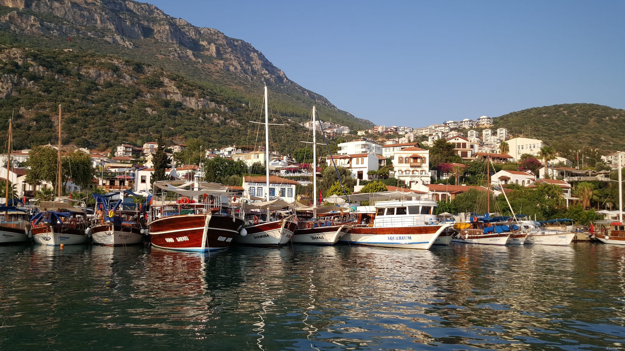
Wooden boats moored side by side along a quay below white houses on a wooded slope, with a bare grey mountain rising behind the town

Antalya & the Mediterranean, Turkey

Kaş

Boats in the harbour at Kaş, below the mountains of the Lycian coast. (Esginmurat / Wikimedia Commons · CC BY-SA 4.0)

A small harbour town on the Lycian coast of Antalya province, built on the site of ancient Antiphellus and backed by steep limestone mountains. Its lanes of bougainvillea-covered houses climb from a yacht harbour that looks across to the Greek island of Kastellorizo, and the town lives from diving, sea kayaking over the sunken ruins of Kekova, and walkers on the Lycian Way.

Neighbourhoods

  • The harbour and old town
    • First-time visitors
    • Best for food
    • Nightlife

    The centre of Kaş, where the quay meets a grid of narrow lanes running uphill under bougainvillea and vine canopies. Restaurants, bars, jewellers and carpet shops fill the old streets, the mosque and the main square sit above them, and a Lycian sarcophagus stands in the middle of one of the lanes.

    Open in Maps
  • Çukurbağ Peninsula
    • Sea views
    • Quiet and residential
    • Swimming platforms

    The long finger of land that curls west from the town, lined with small hotels and villas on the rock above the water. There is no beach, but ladders and platforms drop straight into deep sea, and the sunsets face the open Mediterranean.

    Open in Maps
  • Küçük Çakıl and Büyük Çakıl
    • Beaches
    • Families
    • Close to the centre

    Two pebble coves on the eastern side of the town, one a few minutes' walk from the harbour and the other a little further round the bay. Both have beach clubs and cafés on the shingle and clear water for swimming.

    Open in Maps
  • Kalkan
    • Boutique hotels
    • Restaurants with views
    • Quiet evenings

    A steeply built former Greek fishing town about half an hour west, its whitewashed houses stacked above a small harbour. Rooftop restaurants and villa rentals dominate, and it is quieter and more expensive than Kaş.

    Open in Maps

Things to do

In and around the town

  • Antiphelluslandmark

    The Lycian and Roman town on which Kaş is built, with a Hellenistic theatre above the sea on the western edge of the centre and rock tombs cut into the cliff behind the houses.

    Open in Maps
  • The Lycian Waytrail

    The waymarked coastal footpath passes through the district, linking Kaş with beaches, ruins and mountain villages along the shore.

    Open in Maps
  • Kaputaş Beachbeach

    A short strip of pale shingle at the mouth of a gorge between Kaş and Kalkan, reached by a long staircase from the coast road.

    Open in Maps
  • Uluburun shipwreck siteattraction

    A Late Bronze Age wreck found off the cape east of Kaş, one of the richest ever excavated; its cargo is displayed in the museum at Bodrum.

    Open in Maps

Boats, islands and diving

  • Kekovaattraction

    An island east of Kaş whose shoreline is lined with the partly submerged ruins of a town lost to earthquakes, visited by boat and by sea kayak.

    Open in Maps
  • Simenalandmark

    The village of Kaleköy beneath a small castle on the Kekova bay, reached by boat or on foot, with ancient ruins standing in the shallows below it.

    Open in Maps
  • Kastellorizoattraction

    The smallest of the Greek Dodecanese islands, a short ferry crossing from Kaş harbour, with a horseshoe of neoclassical houses around its port.

    Open in Maps

Lycian cities along the coast

  • Patarabeach

    A long dune-backed beach beside the excavated harbour city, which has a triple triumphal arch of about 100 AD, the assembly building where the Lycian League met, and the remains of a lighthouse.

    Open in Maps
  • Xanthoslandmark

    The chief city of ancient Lycia and a UNESCO World Heritage Site, known for its pillar tombs, inscribed stele and hillside theatre.

    Open in Maps
  • Letoonlandmark

    The federal sanctuary of the Lycian League, with three temples beside a spring, listed by UNESCO together with Xanthos.

    Open in Maps
  • Myralandmark

    An ancient city above Demre, east of Kaş, with a large Roman theatre and a cliff face of house-shaped rock tombs.

    Open in Maps

Eat and drink

Long-standing places and food districts in Kaş. Hours, ratings and directions come from your maps app, always current.

Eating in Kaş

  • The old town lanesneighborhood

    Restaurants and meyhanes on the lanes above the harbour serve meze tables, grilled fish and slow-cooked lamb under vines and bougainvillea; several of the streets are closed to traffic in the evening.

    Open in Maps
  • The harbour frontneighborhood

    Fish restaurants and cafés along the quay, with boats moored alongside and Kastellorizo visible across the strait.

    Open in Maps

Markets and local produce

  • Kaş weekly marketmarket

    The town's open-air market, held on Fridays, brings produce from the villages of the Lycian hinterland — tomatoes, citrus, olives, almonds, herbs, honey and village cheeses — along with clothes and household goods.

    Open in Maps
  • Village breakfast places on the hill roadsrestaurant

    Simple places on the roads inland serve the long Turkish breakfast with village bread, olives, honey and clotted kaymak, and gözleme cooked on a griddle.

    Open in Maps

Experience Kaş

History

The town stands on Antiphellus, which began as the port of the Lycian settlement of Phellos in the hills above and grew into the larger of the two. It joined the Lycian League, minted its own coins, and became the largest city of the district, known for the sponges of its coast; the Hellenistic theatre above the western shore and the rock-cut tombs in the cliff behind the modern houses date from those centuries, as does the free-standing Lycian sarcophagus that sits in one of the town's lanes. Christianity came early to this coast, and Antiphellus had a bishop.

Through the Byzantine, Seljuk and Ottoman periods the place was a small harbour of mixed population, known in Greek as Andifli. Its Greek Orthodox residents made their living from fishing, sponge diving and trade with the island of Kastellorizo, a few kilometres offshore, which was far the busier port in the 19th century. That community left in the compulsory exchange of populations agreed in 1923, and many of the houses in the old lanes are theirs.

For most of the 20th century Kaş was a remote fishing and farming town on a road that barely existed; the coastal highway from Fethiye to Antalya reached it only in the second half of the century. Tourism arrived later and more gently than at Bodrum or Marmaris, and the district's building rules have kept the town low-rise and largely free of the big resort hotels found elsewhere. Diving, launched here in part by the discovery of ancient wrecks offshore — among them the Bronze Age ship found at Uluburun in 1982 — sea kayaking and walking on the Lycian Way, which was waymarked in the 1990s, gave Kaş the outdoor reputation it has today.

Culture & Customs

Kaş attracts a different crowd from the package resorts further east: divers, walkers, sailors and independent travellers, along with many Turkish visitors from Istanbul and Ankara, some of whom have bought houses here. That mix has produced a town of small hotels, dive schools and owner-run restaurants rather than large chains, and a season that revolves around the water.

Beneath it the town remains a Turkish provincial centre with a farming hinterland. Villages in the mountains behind the coast grow almonds, olives and greenhouse vegetables, keep goats on the high pastures in summer in the Yörük tradition, and come down to the weekly market. Craft shops in the lanes sell kilims and jewellery, and the sarcophagus standing among the houses is treated as an ordinary part of the street rather than a monument.

Relations with Kastellorizo shape local identity: the island is visible from the harbour, a small ferry crosses in season, and families on both sides have long memories of the trade and the population exchange that separated them. Evening life is low-key by resort standards — a meze table, rakı, live Turkish music in a few bars, and the habit of walking the harbour after dark. Visitors are expected to dress and behave a little more quietly here than at the beach resorts, and the town takes some pride in that.

Daily Life

The town has only a few thousand residents, with several tens of thousands in the wider district that stretches along the coast and up into the mountains. The population multiplies in summer, when seasonal workers arrive from inland provinces and the hotels, boats and restaurants run every day, and shrinks sharply in winter, when many businesses close and the streets belong to the town again.

Tourism is the main employer, and an unusually specialised one: dive centres, kayak and boat operators, gulet crews, walking guides and small hotels. Around them the older economy continues — fishing from the harbour, greenhouse vegetables and citrus on the coastal flats, almonds and olives on the terraces, beekeeping in the pine forest, and goat and sheep herding on the mountain pastures.

The rhythm is set by boats leaving in the morning and returning in the late afternoon, by the weekly market, and by the long midsummer evenings when the lanes fill after the heat drops. Water supply, the strain of summer traffic on a single narrow road, building pressure on the peninsula and the coast, and the risk of fire and earthquake are the recurring local concerns, along with the question of how much more tourism a town of this size can absorb.

Food

The food is Lycian coastal cooking: olive oil, lemon, herbs and whatever the sea and the gardens provide. Meze tables carry samphire dressed with lemon and olive oil, wild greens from the hillsides, broad beans, aubergine salads, stuffed vine leaves and yoghurt with garlic, eaten slowly with rakı, the aniseed spirit taken with water and ice. Fish — sea bass, bream, red mullet, calamari and octopus — is grilled plainly and served with rocket and lemon.

Meat dishes come from the hinterland. Tandır lamb, cooked slowly until it falls apart, and testi kebab, sealed in a clay pot and broken open at the table, appear on menus in the villages behind the town, and köfte, pide and lahmacun are the everyday standards. Gözleme, thin dough folded over cheese, potato or wild greens and cooked on a convex griddle, is made at market stalls and roadside places.

Local produce is the strength of the district: almonds, olives and olive oil pressed nearby, citrus and pomegranates from the coastal flats, carob, figs and grapes, and pine honey from the forest, a dark honey made from insect secretions rather than blossom and produced in quantity along this coast. Breakfast is the long Turkish spread of cheeses, olives, tomatoes, eggs, jams and honey with clotted kaymak; tea is drunk in small tulip glasses throughout the day, Turkish coffee after meals, and ayran, salted diluted yoghurt, with grilled meat.

Planning tools

Budget

Kaş is one of the more expensive small towns on this coast, along with Kalkan, and prices rise steeply in July and August. Pensions and small family hotels in the centre are reasonable, peninsula hotels and villas are not, and the main extra costs are diving, boat trips and kayak days. Eating is cheap by the standards of the resorts further east.

Daily Budget Midrange
USD 90–200 (boutique hotel, restaurant dinners, site tickets, a boat trip to Kekova)
Daily Budget Shoestring
USD 30–55 (pension in the centre, lokanta meals, dolmuş and buses)

Book accommodation well ahead for July and August, when the town fills; May, June, September and October cost much less and the sea is still warm.

Best Time to Visit

April to June and September to early November. The sea is warm from late spring to autumn, the Lycian Way is walkable in spring and autumn but too hot in midsummer, and diving conditions are good through the season. July and August are hot and crowded. Winter is mild and green but wet, and many hotels, boats and restaurants close. The seasons themselves are unchanged by the war that began in February 2026, although aviation and tourism across the wider region have been disrupted.

Suggested Number of Days

Two or three days suits the town and one day on the water. Four to six allows more time at sea, the ancient cities along the coast and sections of the footpath. Divers and walkers routinely stay a week or more, and travelling without a car adds time.

First Visit
2–3 days
With Surroundings
4–6 days

Transportation

The town itself needs no transport. Dolmuş minibuses run along the coast road to Kalkan, Patara and Demre and inland to the villages, and intercity buses leave for Antalya, Fethiye and further afield from the small bus station above the centre. Boats leave the harbour for Kekova, the islands and, in season, Kastellorizo. A hire car or a scooter makes the scattered ruins and coves much easier.

The coast road is narrow and winding with steep drops and heavy summer traffic; journeys take far longer than the map distance suggests.

Airport & Station Connections

Dalaman Airport is about 170 kilometres west and Antalya Airport about 190 kilometres east; both are roughly three to four hours away by road, with buses, shuttles and private transfers. Intercity coaches reach Kaş from Antalya, Fethiye, İzmir and Istanbul, and a small ferry crosses to Kastellorizo in season. Air travel across the Middle East has been disrupted since the war that began in February 2026, and schedules at the region's airports can change at short notice.

Walkability

The centre is entirely walkable and largely pedestrian in the evenings, but it is built on a slope and almost every walk involves steps or a climb. The harbour, the old lanes, the theatre and the nearer cove are all within about fifteen minutes of each other. The Çukurbağ Peninsula is a long, hot walk from town and most people take a minibus or taxi.

Safety

A quiet town with little crime beyond occasional petty theft. The real risks are on the water and the roads: boat traffic in swimming areas, diving and kayaking accidents, and a narrow coastal highway with sharp bends. Summer heat is severe on the footpaths, wildfires are a risk in the pine forests, and the region is seismically active, with earthquakes felt from the nearby fault zone.

Use licensed dive and kayak operators, carry water and a phone on the Lycian Way and leave word of the route with someone, and follow local instructions during wildfires. Check current official travel advice before travelling.

Climate

A Mediterranean climate: hot dry summers, mild wet winters, and mountains that rise steeply behind the coast so that the hinterland is cooler and snowier than the shore. Sea temperatures stay comfortable from May into November.

Summer
hot and dry — July and August days are commonly 32–36°C, tempered near the water by a sea breeze
Winter
mild and wet — January days are typically 14–16°C, with heavy rain and snow on the mountains inland

Local Customs

Beachwear belongs on the shore and not in the lanes or shops. Shoes come off at the mosque, and shoulders, knees and hair should be covered inside. Tipping of around ten per cent is normal in restaurants. Bargaining is expected in carpet and craft shops but not elsewhere. Alcohol is sold freely, and tea offered in a shop carries no obligation. The town is small enough that manners matter and greetings are returned.

Ask before photographing people at the weekly market; taking antiquities or pieces of stone from Lycian sites out of Turkey is a serious criminal offence, and the sunken ruins at Kekova may not be swum over or landed on where marked.

Common Payment Methods

The currency is the Turkish lira. Cards are taken by hotels, dive centres and most restaurants, but cash is needed for dolmuş minibuses, market stalls, village cafés and some boat trips. ATMs are in the centre of town and in Kalkan, and exchange offices give better rates than hotels.