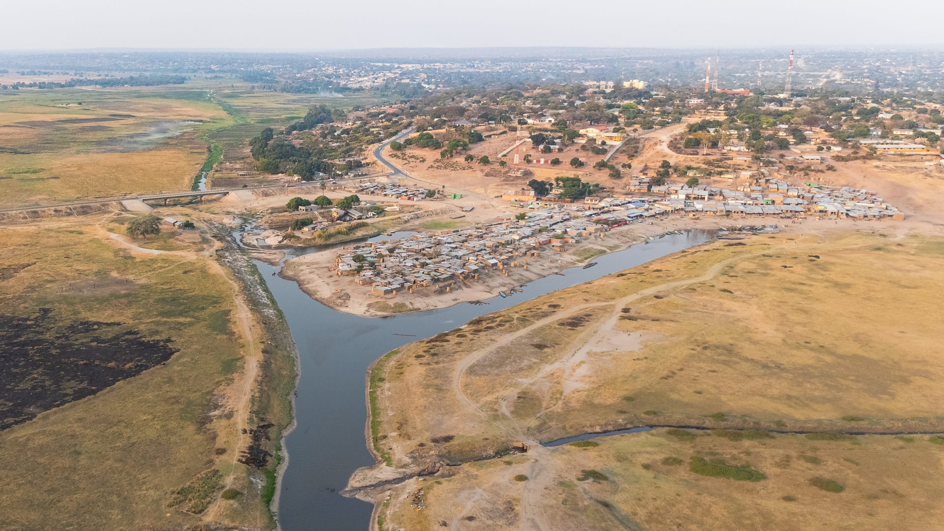
Aerial view of a town on a sandy ridge meeting a flat green floodplain, with a channel of water curving past clustered houses

Livingstone, Victoria Falls & the West, Zambia

Mongu

The edge of Mongu where the town meets the Barotse Floodplain, Western Province, Zambia. (Petrtyl / Wikimedia Commons · CC BY 4.0)

The capital of Zambia's Western Province and the main town of Barotseland, built on a sand ridge above the Barotse Floodplain of the Zambezi. It is the commercial and administrative centre of the Lozi kingdom, tied to the plain below by a harbour, a canal and a causeway, and best known for the Kuomboka, the royal barge ceremony held when the flood rises.

Neighbourhoods

  • The town centre on the ridge
    • First-time visitors
    • Markets
    • Close to transport

    Shops, banks, provincial offices, the bus station and the main market stand on the sandy high ground, along the road that comes in from Lusaka. It is dusty, busy and compact, and the plain appears suddenly at the western edge.

    Open in Maps
  • The harbour and the plain's edge
    • Views
    • Boats
    • Local life

    Below the ridge the land drops to the harbour and canal, where dugouts, water taxis and cargo boats load for the Zambezi. Fish and reed markets, boat builders and the causeway west across the floodplain are all here, and the sunsets over the plain draw people to the escarpment road.

    Open in Maps
  • Limulunga
    • Historic sites
    • Ceremonies
    • Quiet and residential

    A settlement about fifteen kilometres north of town on higher ground, the Litunga's residence during the flood season and the destination of the Kuomboka barge. The royal buildings stand here, and the village is quiet outside ceremony time.

    Open in Maps
  • The outer compounds
    • Local life
    • Quiet and residential

    Housing areas spread along the sand roads north and east of the centre, built around churches, schools and small markets. Most of Mongu's people live here, in a mix of brick and traditional houses among mango trees and cassava plots.

    Open in Maps

Things to do

The floodplain and the river

  • Barotse Floodplainattraction

    The Zambezi's great seasonal plain west of the town, flooded from about January to June and farmed and grazed when the water falls, with villages on the mounds and canoes as the main transport.

    Open in Maps
  • Mongu harbour and canaltransit hub

    The cut that links the town's landing to the Zambezi across the plain, where dugouts, water taxis and cargo boats load timber, fish and produce.

    Open in Maps
  • The escarpment viewpointsviewpoint

    The road along the ridge above the harbour gives a long view west over the plain, which becomes an inland sea at the height of the flood.

    Open in Maps

Barotseland and the royal capitals

  • Limulunganeighborhood

    The Litunga's flood-season residence on high ground north of Mongu, where the Kuomboka barge arrives and where the province's museum of Lozi culture stands.

    Open in Maps
  • Lealuiattraction

    The royal capital out on the plain, occupied when the water is low and abandoned each year to the flood — the starting point of the Kuomboka procession.

    Open in Maps
  • Nayuma Museummuseum

    A museum devoted to the arts and crafts of Barotseland, begun in the 1980s, with material on Lozi culture and the history of the kingdom.

    Open in Maps

Short trips from the town

  • Liuwa Plain National Parkpark

    A vast open grassland with one of Africa's large wildebeest migrations, hyena clans and enormous skies, remote even by Zambian standards.

    Open in Maps
  • Kalaboattraction

    A small town on the western side of the floodplain, reached by the causeway and river crossing, and the administrative jumping-off point for Liuwa Plain.

    Open in Maps

Seasonal events

  • KuombokaMarch or April, at the end of the rains when the flood rises

    The Lozi ceremony in which the Litunga is paddled from Lealui to Limulunga in the Nalikwanda, a great black-and-white barge, with royal drums, paddlers in regalia and crowds along the water; its date is set by the height of the water and the phase of the moon.

  • Independence Day24 October

    The national holiday is marked in Mongu with parades, church services and sports at the provincial grounds, in the hot weeks before the rains.

Eat and drink

Long-standing places and food districts in Mongu. Hours, ratings and directions come from your maps app, always current.

Mongu classics

  • Barotse ricerestaurant

    The floodplain is Zambia's main rice-growing area, and rice appears alongside or instead of nshima on local plates, often with fish or a groundnut relish.

    Open in Maps
  • Bream and dried floodplain fishrestaurant

    Bream, tigerfish and catfish come from the Zambezi and its channels, eaten fresh when the water is high and smoked or dried the rest of the year.

    Open in Maps

Markets and stalls

  • Mongu main marketmarket

    Cassava and maize meal, rice, groundnuts, vegetables, dried fish and Lozi baskets and mats fill the stalls of the central market.

    Open in Maps
  • The harbour fish marketmarket

    Fish landed from the plain are sold and smoked near the canal, alongside reeds, timber and produce brought in by boat.

    Open in Maps

Experience Mongu

History

The Lozi — also called the Barotse — built a kingdom on the Zambezi floodplain from around the seventeenth century, organised around the annual flood, a network of canals dug across the plain, and a king, the Litunga, with capitals on the plain and on its margins. In the 1830s the Makololo, invaders from the south under Sebitwane, conquered the kingdom, leaving behind their language, which became Silozi; the Lozi regained power in 1864.

Mongu itself is a colonial-era town. Paris Evangelical missionaries established stations on and around the plain from the 1880s, and the settlement on the sand ridge grew as a trading and administrative post for Barotseland, whose king Lewanika signed a series of concessions from 1889, granting the British South Africa Company mining rights across the kingdom in 1890. Barotseland kept a distinct status under British rule, and Mongu became its administrative centre, while the royal capitals at Lealui and Limulunga remained the seat of Lozi authority.

The Barotseland Agreement of 1964 folded the territory into independent Zambia with guarantees that were later abrogated, and the question of Barotse autonomy has recurred in provincial politics ever since. Mongu grew slowly, hampered by distance and sand roads, until the tarred highway from Lusaka and, more recently, the causeway west across the plain improved its links. The town is now the province's administrative hub, with a university campus, hospitals and the provincial market for rice, cattle, fish and timber.

Culture & Customs

Mongu is the urban face of one of Africa's best-known surviving monarchies. The Litunga, his council and the Barotse Royal Establishment hold authority over customary land and ceremony, and respect for royalty is expressed in formal manners — kneeling, clapping and specific forms of address — that outsiders are expected at least to recognise. Silozi, a Sotho language left by the Makololo, is the common tongue, spoken far beyond the Lozi themselves.

The Kuomboka is the great public occasion: the move of the Litunga from the plain to higher ground in the Nalikwanda, a great black-and-white barge with an elephant on its roof, propelled by dozens of paddlers in ceremonial dress, with royal drums, attendant boats and crowds lining the water. Its date is set by the height of the water and the phase of the moon, and the province plans around it once it is announced.

Beyond the ceremonies, the plain shapes the culture: canoe handling, cattle, fishing, and a calendar of movement between wet-season and dry-season villages. Basketry and mat weaving from plain grasses and palm are a Lozi craft of long standing, sold in Mongu's markets. Churches, particularly of the Protestant missions established in the nineteenth century, are central, and Mongu's social life runs to church, football and family gatherings.

Daily Life

About 180,000 people live in Mongu, the province's main town and its administrative capital. It is built on Kalahari sand, and the sand is a daily fact: roads, yards and paths are soft and pale, walking is slow, and vehicles need care away from the tarred streets.

The economy is trade and administration. Provincial and district offices, the hospital, schools and a university campus are the main formal employers, and the markets move rice, cassava, maize, cattle, fish and timber between the plain and the rest of the country. Households on the plain's edge farm, fish and keep cattle, moving with the water: gardens and villages on the plain in the dry season, higher ground when the flood comes.

Western Province is among Zambia's poorer provinces, and Mongu shows it in thin infrastructure, irregular electricity during national load-shedding, and limited work for young people, many of whom leave for Lusaka or the Copperbelt. Better roads have brought traders and goods, and the town is busier than it was, but the rhythm still follows the flood: the harbour thrives when the water is high, and the plain fills with cattle when it falls.

Food

The floodplain feeds Mongu. Rice grown on the plain is a local speciality in a country otherwise built on maize, and it is eaten alongside or instead of nshima, the stiff porridge that remains the staple; in the west that porridge is often made from cassava meal. Fish is the usual relish — bream, tigerfish and catfish from the Zambezi and its channels, fresh in the flood and smoked or sun-dried the rest of the year.

Beef and soured milk reflect the Lozi cattle economy, and relishes of pumpkin leaves, cassava leaves, okra and beans are cooked with groundnuts. Wild foods from the plain and the woodland — mushrooms in the rains, water-lily roots, fruits such as mango and the tart masau — fill out the year. Cassava is eaten boiled and pounded as well as milled, and roadside stalls sell it roasted with groundnuts.

Markets sell the plain's produce in season, and the harbour area smokes fish over low fires. To drink there is munkoyo, the lightly fermented maize and root drink that is especially popular in the west, home-brewed beers, Chibuku sold in cartons, bottled lager, and strong sweet tea taken with bread or fritters in the morning.

Planning tools

Budget

Mongu is a working provincial town rather than a resort, and prices are modest: guesthouses and small hotels in and around the centre, cheap local food, and buses from Lusaka. Costs climb only for trips onto the plain, which need a boat and a boatman, and for the far west, where a 4x4 and fuel are essential.

Daily Budget Midrange
USD 130–330 (hotel or lodge, hired vehicle or boat, guided trips onto the floodplain)
Daily Budget Shoestring
USD 30–60 (guesthouse, market food, buses and shared transport)

Draw kwacha in town, since cash machines are scarce further west, and book rooms well ahead if the Kuomboka is expected.

Best Time to Visit

The dry months from May to October are easiest for travel, with firm roads and the plain grazed and settled. The flood, at its widest around March and April, is the spectacle, and the Kuomboka is held at the end of the rains when the water allows. November to April brings storms and difficult sand and dirt roads.

Suggested Number of Days

A day or two is enough for the town, the harbour and the royal settlements nearby. Three to five days suit a boat trip on the plain or a journey further west. A visit built around the ceremony needs flexibility, since its timing depends on the flood.

First Visit
1–2 days
With Surroundings
3–5 days

Transportation

The town is small enough to cross on foot or by shared taxi and minibus, and buses run east to Lusaka and north and south along the province's roads. The plain itself is travelled by boat: dugouts, motorised water taxis and cargo boats from the harbour. The causeway road west carries traffic to Kalabo when conditions allow.

Hire a boat with a boatman rather than attempting the channels alone, and use a 4x4 with high clearance on the sand roads away from the tarred highway.

Airport & Station Connections

Mongu lies at the western end of the tarred highway from Lusaka, about 600 kilometres away, a full day by bus, with the road crossing Kafue National Park on the way. Buses run daily; the town also has an airport, used mostly by government, aid and charter flights. From Mongu the causeway carries the road west across the floodplain towards Kalabo.

Walkability

The centre is flat, sandy and walkable, with the market, banks and bus station close together, though the sand and the heat make longer walks tiring. The harbour lies below the ridge, a steep but short descent from town, and the outlying compounds and Limulunga are too far to reach on foot.

Safety

Western Province is peaceful and crime against visitors is rare, though the market and bus station call for the usual care with bags. Practical risks are those of remoteness and water: long distances between medical facilities, crocodiles and hippos in the channels, bilharzia in still water, deep sand on the roads, and malaria year-round. Demands for Barotseland's autonomy have occasionally led to tense demonstrations.

Change money at banks or bureaux, swim only at guided sites, carry water and fuel on western roads, and take malaria precautions. Check current official travel advice before travelling.

Climate

Mongu sits on Kalahari sand at around 1,000 metres, with a wet season from November to April that fills the plain and a long dry season from May to October. The flood peaks well after the rains, around March and April. Being in the southern hemisphere, summer falls in December to February.

Summer
December to February is hot and wet, generally 28–32°C by day with afternoon storms
Winter
June to August is dry and sunny, around 25–28°C by day, with cold nights on the sand

Local Customs

This is the heartland of the Lozi kingdom, and the Litunga and the Barotse Royal Establishment command deep respect. Silozi is the common language, with English in offices. Greetings are formal and unhurried, and Lozi custom includes distinctive gestures of respect towards royalty, including kneeling and clapping.

Dress modestly, ask permission before photographing royal buildings, ceremonies or people, follow local instruction at the Kuomboka and around the palaces, and greet elders before starting any conversation.

Common Payment Methods

The currency is the Zambian kwacha, and cash rules outside the few hotels. Banks and cash machines are in the centre of Mongu and can run out at busy times; there is little beyond them to the west. Mobile money is widely used for transfers and small payments, and cards work only at larger establishments.