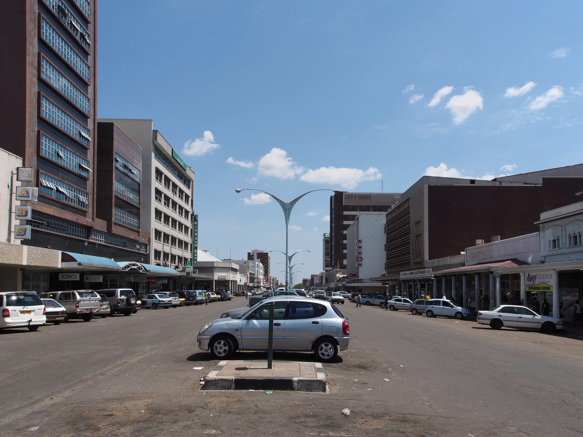
A very wide city street with parking down the middle, low shopfronts with awnings on one side and office blocks on the other under a blue sky

Victoria Falls, Bulawayo & Matabeleland, Zimbabwe

Bulawayo

One of the wide central streets of Bulawayo, laid out on the city's original grid. (Sputniktilt / Wikimedia Commons · CC BY-SA 4.0)

Zimbabwe's second city and the heart of Ndebele Matabeleland, founded by settlers in 1893 on the site of King Lobengula's royal town. Laid out on a grid of exceptionally wide streets, it became the country's railway and industrial centre, and it keeps colonial-era arcades, the national Natural History Museum and a strong arts and football culture.

Neighbourhoods

  • The city centre
    • First-time visitors
    • Architecture
    • Close to public transport

    A numbered grid of avenues and streets wide enough for a wagon team to turn, lined with verandas, arcades and early twentieth-century commercial buildings. The museums, the city hall, the main market and the bus ranks are all within it, and it is easy to cross on foot by day.

    Open in Maps
  • Makokoba
    • History
    • Local life
    • Music

    The city's oldest township, laid out beside the centre in the early colonial years and long the centre of Ndebele urban life, nationalist politics and music. It is dense and busy, with a well-known market and a reputation for producing musicians and footballers.

    Open in Maps
  • Hillside and Burnside
    • Quiet and residential
    • Gardens and walks

    Low-density suburbs on rising ground south-east of the centre, with large gardens, granite outcrops and quiet roads. The Hillside dams and their birdlife are here, and many guesthouses are in this part of the city.

    Open in Maps
  • Khumalo and Suburbs
    • Quiet and residential
    • Sport

    The older leafy districts immediately around the centre, named for the Ndebele royal house, with jacaranda-lined avenues, schools, sports clubs and embassies-turned-offices. They are a short drive or a long walk from the centre.

    Open in Maps
  • Nkulumane and the western townships
    • Local life
    • Markets
    • Cheap eating

    The large high-density suburbs west and south of the centre, where most of Bulawayo's people live, with their own markets, taxi ranks, churches and grills. Little is aimed at visitors, but this is where the city's everyday life takes place.

    Open in Maps

Things to do

Museums and galleries

  • Natural History Museum of Zimbabwemuseum

    The national natural history collection, opened in Centenary Park in 1964, with mammal and bird displays, geology and palaeontology galleries and the world's second largest mounted elephant.

    Open in Maps
  • National University of Science and Technologylandmark

    The state technical university founded in Bulawayo in 1991, whose campus outside the centre brought thousands of students to the city.

    Open in Maps
  • Bulawayo Railway Museummuseum

    Steam locomotives, coaches and railway equipment kept beside the main line in the city that was the hub of Rhodesia's railways, including engines from the Cape-to-Cairo era.

    Open in Maps
  • National Gallery in Bulawayomuseum

    The Bulawayo branch of the National Gallery of Zimbabwe, opened in 1970 and since 1993 housed in Douslin House on Main Street, an elegant two-storey building of 1901.

    Open in Maps

Landmarks and parks

  • Old Bulawayolandmark

    The site of the capital King Lobengula established in 1870, south of the modern city, a national monument with a museum, being rebuilt by National Museums and Monuments.

    Open in Maps
  • Barbourfields Stadiumattraction

    The city's main football ground, close to the western townships, home of Highlanders and the focus of Bulawayo's football culture.

    Open in Maps
  • Joshua Mqabuko Nkomo International Airporttransit hub

    The city's airport about 15 km north of the centre, named after the nationalist leader from Matabeleland, handling domestic and regional flights.

    Open in Maps
  • City Halllandmark

    The civic centre of the city, whose grounds are a place where artists set out carved sculptures for sale.

    Open in Maps
  • Centenary Parkpark

    A city park with an amphitheatre, lawns and a large fountain, and the setting of the Natural History Museum.

    Open in Maps
  • Hillside Damspark

    Dams on the city's south side completed in 1898 for the water supply, a national monument since 1942 and now a bird sanctuary with walking trails.

    Open in Maps
  • Chipangaliattraction

    A wildlife orphanage founded in 1973 by a former game ranger and his wife, caring for orphaned, abandoned and sick wild animals; a favourite visit with children.

    Open in Maps

Short trips from the city

  • Matobo National Parkpark

    A national park in the balancing granite hills of the Matobo range, part of a UNESCO World Heritage Site inscribed in 2003, with painted caves, white and black rhino and Cecil Rhodes's grave at World's View.

    Open in Maps
  • Khami Ruinslandmark

    A UNESCO World Heritage Site about 22 km west of the city, where terraced dry-stone platforms mark the capital of the Torwa state that succeeded Great Zimbabwe.

    Open in Maps
  • Cyrene Missionlandmark

    The mission school near the city where the Anglican priest Edward Paterson taught art from 1939, drawing a royal visit in 1947 and producing some of the country's first professional African artists.

    Open in Maps
  • Nswatugi Cavelandmark

    A granite shelter in the Matobo hills holding rock-art friezes of giraffe, elephant and kudu.

    Open in Maps
  • Malindidzimuviewpoint

    The hill known as World's View, a dome of balancing granite where Cecil Rhodes is buried, with wide views across the Matobo landscape.

    Open in Maps

Seasonal events

  • Zimbabwe International Trade FairApril or May

    The country's main trade exhibition, held at the showgrounds in Bulawayo, filling the city's hotels for a week each year.

  • Intwasa Arts FestivalSeptember

    A multi-day arts festival in the city with theatre, poetry, music and visual art, organised around venues in and near the centre.

  • Jacaranda and flowering seasonSeptember and October

    The avenues of the older suburbs flower purple and red in the hot weeks before the rains, the most pleasant time to walk in the residential streets.

Eat and drink

Long-standing places and food districts in Bulawayo. Hours, ratings and directions come from your maps app, always current.

Bulawayo classics

  • Isitshwala with amasirestaurant

    The Ndebele name for maize porridge, served with thick soured milk or with beef stew and greens, is the dish of this cattle country and appears from township canteens to sit-down restaurants.

    Open in Maps
  • Braai grills in the townshipsrestaurant

    Beef and goat grilled over coals, often bought at a butchery counter and cooked on the spot, eaten with isitshwala and relish at bars and grills in the western suburbs.

    Open in Maps

Markets and food districts

  • Makokoba marketmarket

    The market in Makokoba, the city's oldest township, selling vegetables, dried mopane worms, herbs, groundnuts and household goods, and a long-standing social centre.

    Open in Maps
  • City centre cafés and arcadesneighborhood

    Tea rooms, bakeries and small restaurants under the verandas and in the arcades of the central grid, serving pies, sadza lunches and coffee to office workers.

    Open in Maps
  • Suburban restaurants around Hillsideneighborhood

    The southern suburbs hold most of the city's sit-down restaurants, garden cafés and bars, spread between shopping centres and sports clubs.

    Open in Maps

Experience Bulawayo

History

The city takes its name from koBulawayo, the royal town that Lobengula established as his capital in 1870, on a site south of the present centre. Lobengula was the son of Mzilikazi, who had led the Ndebele north from the upheavals in South Africa in the 1830s and settled in this granite country about 1840. The royal town was the political centre of that kingdom, where envoys, traders and concession-hunters came to negotiate, and where the concession that gave Cecil Rhodes's British South Africa Company its foothold was signed in 1888.

War followed in 1893. Lobengula burned the royal town and withdrew northwards, dying soon afterwards, and the company's settlers laid out their own town on and near the site, with streets famously wide — the story told locally is that they were built for a span of oxen to turn. The Ndebele rose in 1896, and the fighting ended in talks that Rhodes held in the Matobo Hills to the south. The railway arrived in the 1890s and made Bulawayo the junction of the region's network, and with the railways came engineering works, factories and a large industrial workforce that drew people from across the country and beyond.

Through the twentieth century the city was Rhodesia's industrial centre and a stronghold of trade unionism and nationalist politics; Joshua Nkomo's ZAPU was rooted here. After independence in 1980 the region suffered the Gukurahundi campaign of 1983 to 1987, in which the army's Fifth Brigade killed thousands of civilians in Matabeleland and parts of the Midlands, a period still unresolved publicly. Industry declined sharply from the 1990s as factories closed, and water shortages and economic contraction have marked the decades since, leaving a city with grand infrastructure and a thinner economy.

Culture & Customs

Bulawayo is the cultural capital of Ndebele Zimbabwe. IsiNdebele, closely related to Zulu, is the language of the street, though Shona, Kalanga and English are all common, and the city's writers, poets and theatre-makers have long given it a reputation for producing work that Harare does not. An arts festival each September, galleries in the centre and a network of small venues keep that going despite the lack of money.

Music is central, and the city's contribution runs from choral and church music through rumba and jazz to the imbube and mbube-style harmony singing associated with this region, and to a lively contemporary hip hop and gospel scene. Dance and drumming traditions of the Ndebele are performed at ceremonies and festivals, and the city has long been a place where township bands and theatre groups train.

Football is followed with unusual intensity. Highlanders, founded in 1926 by grandsons of King Lobengula, carries the city's identity, and its matches against Harare sides fill Barbourfields. Feeling that Matabeleland has been neglected by national governments is widespread and shapes local politics and conversation, with the Gukurahundi remembered in families across the region. Manners are formal and unhurried: greetings first, deference to elders, and a strong emphasis on hospitality and on funerals as community occasions.

Daily Life

About 665,000 people lived in Bulawayo at the 2022 census, making it the second city after Harare, though its population has grown slowly as people have left for South Africa, Botswana and the capital. Most residents live in the western and southern high-density suburbs; the older low-density districts near the centre remain leafy and quiet.

The economy is a shadow of the industrial one. Textile mills, engineering works and the railway workshops that once employed tens of thousands have largely closed or shrunk, and employment now comes from trade, transport, services, schools and hospitals, with a large informal sector of vendors and small workshops. Cross-border trade with South Africa and Botswana is important, and remittances from relatives abroad support many households. Cattle ranching and dry-land farming dominate the country around the city.

Water is the city's defining daily problem: supply dams depend on an erratic rainfall, and rationing schedules that leave suburbs dry for days at a time have been a fact of life for years, with boreholes and stored water in most yards. Power cuts are frequent as well. The day starts early, the centre is busy with commuters and vendors by mid-morning and empties by early evening, and weekends belong to churches, football and family gatherings. For all the strain, the city keeps a reputation for orderliness and for a slower, more courteous pace than Harare.

Food

The staple is isitshwala, the Ndebele name for the stiff maize porridge that Shona speakers call sadza, eaten by hand with a relish. The pairing the city is known for is isitshwala with amasi, thick soured milk, a natural dish for cattle country and a mainstay of Ndebele home cooking. Relishes otherwise mean vegetables such as imifino or covo cooked with tomato and onion, beans, groundnuts, or a stew of beef or goat.

Mopane worms, called amacimbi here, are the regional delicacy: the caterpillars of the emperor moth are harvested from mopane woodland, gutted and dried in the sun or smoked, then fried with onion and tomato and served with isitshwala. They are sold dried by the cupful in the markets, and they matter economically as well as culinarily in the drier districts.

Meat grilled over coals is the food of gatherings, and the city's butchery-grills, where a cut is chosen at the counter and cooked on the spot, are an institution. Inkobe, boiled whole maize, sometimes with beans, is a common snack, and street vendors sell roasted maize cobs, maputi, puffed maize, and boiled groundnuts. Traditional sorghum beer, brewed for ceremonies, and Chibuku, the opaque sorghum-and-maize beer sold in cartons, are the customary drinks, with maheu, a non-alcoholic fermented maize drink, and bottled lager alongside them.

Planning tools

Budget

Bulawayo is one of the better-value places in Zimbabwe. Guesthouses in the southern suburbs and small hotels in the centre cost well below Harare or Victoria Falls prices, and local food is cheap. The main expense is transport to the sights outside the city, since Matobo and Khami need a hired car, a taxi or a guided trip.

Daily Budget Midrange
USD 150–350 (hotel or lodge, restaurant meals, a hire car or a guided day in Matobo)
Daily Budget Shoestring
USD 45–80 (backpackers or guesthouse, local meals, shared taxis, one museum or park entry)

Carry small, clean US dollar notes; cards work in some supermarkets and hotels, and a guided trip is often cheaper than hiring a car for a single day in the hills.

Best Time to Visit

April to October is the most comfortable, with dry, sunny days, cold nights in June and July and clear light in the hills. September and October are hot and dusty before the rains and are when the trees flower. The rains from November to March are short and heavy, greening the Matobo hills.

Suggested Number of Days

Two days cover the city itself at an unhurried pace. Three or four suit visitors who also want the granite country and the archaeological sites outside it, which is what most people come for. Arranging transport beyond the city is the main thing that changes the total.

First Visit
2 days
With Surroundings
3–4 days

Transportation

The city is laid out on a generous grid and is easy to drive in, with little congestion by regional standards. Shared minibuses run from ranks in the centre to all the suburbs, cheaply and without timetables, and metered taxis and ride-hailing operate in the city. Hire cars and hired drivers are the usual choice for Matobo and Khami; trains run to Victoria Falls and elsewhere on a limited basis.

Agree a fare before setting off if a taxi has no meter, and arrange the return leg when visiting Khami or Matobo, where passing transport is scarce.

Airport & Station Connections

Joshua Mqabuko Nkomo International Airport lies about 15 km north of the centre, roughly half an hour by road, with domestic and regional flights. Coaches run to Harare in about five to six hours, to Victoria Falls, and south to Beitbridge and the South African border. The railway line through the city connects Victoria Falls and the south, and Bulawayo remains the hub of the national rail network.

Walkability

The central grid is flat, orderly and pleasant to walk by day, with the museums, parks and main shopping streets within a kilometre or so of each other, though the streets are so wide that crossings take longer than in most cities. The suburbs and townships are spread out and need transport, and walking in the centre after dark is not advised.

Safety

Bulawayo is calmer than Harare, and violent crime against visitors is uncommon. Pickpocketing and bag-snatching occur in the centre, around the bus ranks and in crowded markets, and the centre empties and feels deserted after dark. Water shortages are a long-running problem in the city, and power cuts are frequent.

Take malaria precautions in the low-lying areas, avoid political gatherings, don't drive at night, keep documents and small change ready for roadblocks, and don't swim in still fresh water outside managed sites. Taxis are the sensible way to move around the city at night. Check current official travel advice before travelling.

Climate

Bulawayo stands at about 1,300 metres in the driest part of the country, so it is warm and sunny for most of the year with a short, sharp rainy season from November to March. Winters are dry with cold nights, and October is the hottest month. Summer here falls in December to February.

Summer
warm to hot, around 28–32°C, with afternoon storms in the wet months
Winter
dry and sunny, with days around 21–25°C and nights that can drop close to freezing

Local Customs

This is Ndebele country, and a greeting in isiNdebele — sawubona, or salibonani to a group — is appreciated before any conversation. Respect for elders is expected, dress is neat and modest in town and in churches, and the Gukurahundi killings of the 1980s are a sensitive subject that residents may raise but visitors should not press. Tipping is not obligatory; around ten per cent is usual in restaurants.

Ask before photographing people or market stalls, and do not photograph police, soldiers or government buildings; in the Matobo hills, shrines such as Njelele are sacred and should be approached only with local guidance.

Common Payment Methods

The ZiG is the official currency, but the US dollar is what most prices are quoted and paid in, and South African rand is sometimes accepted because of the strong links to South Africa. Small, clean notes matter, as change is hard to come by. Cards work in larger supermarkets, hotels and some restaurants, mobile money is widely used by residents, and ATMs are unreliable.