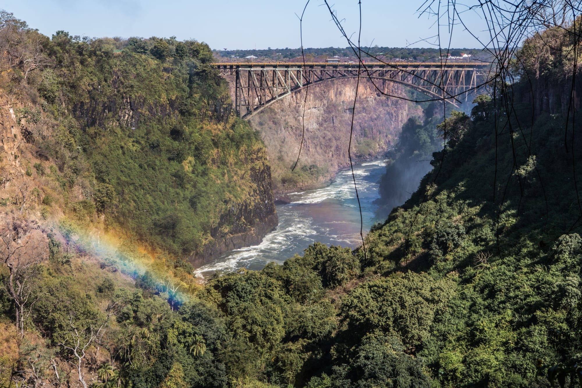
A steel arch bridge spanning a deep wooded gorge, with the green Zambezi far below and a rainbow in the spray

Victoria Falls, Bulawayo & Matabeleland, Zimbabwe

Victoria Falls

The Victoria Falls Bridge across the Zambezi gorge below the falls, with spray rainbows on the Zimbabwean side. (Ninaras / Wikimedia Commons · CC BY-SA 4.0)

A small town in north-western Zimbabwe beside the waterfall the Zambezi makes as it drops into a basalt chasm, known locally as Mosi-oa-Tunya, the smoke that thunders. It began as a settlement in 1901 and grew, once the railway arrived and the bridge opened in 1905, into the country's main tourist centre, with the rainforest walk, the gorges, river cruises and the Zambian border a short distance apart.

Neighbourhoods

  • The town centre
    • First-time visitors
    • Close to the falls
    • Craft markets

    A few blocks of shops, tour offices, restaurants and craft stalls between the railway line and the park entrance, with the rainforest walk within twenty minutes on foot. Almost everything a visitor needs is here, and it is the one part of town built for walking.

    Open in Maps
  • The riverside strip
    • Quiet and residential
    • River views
    • Sunset cruises

    The road running upstream along the Zambezi north-west of the centre, lined with lodges in large grounds among mopane and teak woodland. Cruise jetties are along this stretch, and elephants and buffalo move through the area at night.

    Open in Maps
  • Chinotimba
    • Local life
    • Markets
    • Cheap eating

    The town's main residential suburb, laid out for workers in the tourist industry and home to most of the permanent population. It has markets, a bus rank, bars and grills, and prices far below those in the centre.

    Open in Maps
  • The airport road and Mkhosana
    • Quiet and residential
    • Close to transport

    The southern approach to the town, with newer residential areas, schools and shops spread along the road towards the airport and the Bulawayo highway. It is practical rather than scenic and needs a vehicle.

    Open in Maps

Things to do

The falls and the bridge

  • Victoria Fallslandmark

    The Zambezi drops more than a hundred metres into a narrow basalt chasm along a front of well over a kilometre, a UNESCO World Heritage Site shared with Zambia.

    Open in Maps
  • Victoria Falls National Parkpark

    The park on the Zimbabwean bank, where a path through spray-fed rainforest passes a series of viewpoints facing the Devil's Cataract, the Main Falls, the Rainbow Falls and the gorge.

    Open in Maps
  • Victoria Falls Bridgelandmark

    The steel arch bridge across the second gorge, opened in 1905 to carry the Cape-to-Cairo railway line, now a road, rail and pedestrian crossing to Zambia and the site of the bungee jump.

    Open in Maps

The river and the parks

  • Zambezi National Parkpark

    A park along the river upstream of the town, with a riverside drive, elephant, buffalo, sable and hippo, and a quieter stretch of the Zambezi above the falls.

    Open in Maps

Short trips from the town

  • Hwange National Parkpark

    A very large park on the edge of the Kalahari sands, known for great elephant herds at pumped waterholes, lion, buffalo and wild dog.

    Open in Maps
  • Livingstoneattraction

    The Zambian town across the bridge, with its own viewpoints facing the Eastern Cataract and museums including the Livingstone Museum.

    Open in Maps
  • Mosi-oa-Tunya National Parkpark

    The Zambian park opposite, combining the falls viewpoints on that bank with a small game section along the river where white rhino are kept.

    Open in Maps

Seasonal events

  • High water and full-moon sprayMarch to May

    The weeks after the rains, when the river is at its fullest, the spray column is visible for many kilometres and lunar rainbows can appear in the spray on nights around the full moon.

  • Low-water seasonSeptember to December

    The months when the river runs at its lowest, opening the clearest views of the rock face and the gorge and the best conditions for rafting below the falls.

Eat and drink

Long-standing places and food districts in Victoria Falls. Hours, ratings and directions come from your maps app, always current.

Victoria Falls classics

  • Game meat grillsrestaurant

    Restaurants in the centre serve grilled beef alongside farmed game such as kudu, eland, warthog and crocodile, usually with sadza or vegetables.

    Open in Maps
  • Sadza and relish in Chinotimbarestaurant

    The town's suburb has plain eating houses and grills where sadza comes with beef or chicken stew, greens, beans or dried fish at local prices.

    Open in Maps

Markets and food streets

  • Town centre craft and food stallsmarket

    Stalls in the centre sell carvings, stone sculpture and basketwork alongside stands with roasted maize, maputi and cold drinks.

    Open in Maps
  • Chinotimba marketmarket

    The suburb's produce market, with vegetables, dried kapenta, groundnuts, fruit and household goods for the people who live in the town.

    Open in Maps

Experience Victoria Falls

History

People lived along this stretch of the Zambezi long before the falls were known abroad; the Tonga, Nambya, Leya and Lozi peoples of the region called the waterfall Mosi-oa-Tunya, the smoke that thunders, and the surrounding basalt country carries both settlement sites and sacred places. In November 1855 David Livingstone, travelling downriver, became the first European recorded to see the falls and renamed them for Queen Victoria, and his account brought them to European attention.

The town itself began in 1901, when the possibility of using the falls for hydro-electric power was explored, and the railway made it. Cecil Rhodes's Cape-to-Cairo scheme pushed the line north from Bulawayo, the line reached the falls in 1904, and the steel arch bridge across the second gorge was completed the following year, deliberately sited where spray from the falls would drift over passing trains. A settlement grew at the railhead around a hotel and station serving visitors arriving by train, and the falls became one of the recognised sights of southern Africa in the early twentieth century.

Tourism has driven every phase since, and politics has repeatedly interrupted it. Travel fell away during the liberation war of the 1970s, when the border area was militarised, then grew strongly after independence in 1980. The economic crisis and hyperinflation of the 2000s emptied the lodges again, and the shift to the US dollar after 2009 brought business back. The airport's runway and terminal were rebuilt in the 2010s to take larger aircraft, and the town has grown quickly around the tourist economy, with new suburbs spreading south towards the airport road.

Culture & Customs

Victoria Falls is a border town and a company town at once: its working life is tourism, and its people come from across Zimbabwe as well as from the Nambya, Tonga and Ndebele communities of the north-west. English is the working language, Ndebele and Shona are both widely heard, and staff in lodges and on boats routinely move between three or four languages in a day.

Craft is the visible local trade. Stone sculpture in serpentine, wood carvings of animals, basketwork and beadwork are made in the district and sold from stalls and roadside pitches, and bargaining is part of the transaction rather than a dispute. Guiding is the town's prestige profession: Zimbabwe's professional guide qualification is demanding and highly regarded, and a good guide's knowledge of the river, the birds and the bush is a point of local pride.

The falls themselves are treated as more than scenery by many residents. The river has long-standing spiritual associations in the region, and Nyami Nyami, the Zambezi river spirit of Tonga belief, is part of the valley's traditions downstream. The town's social life centres on churches, football and the bars and grills of Chinotimba rather than on the tourist strip, and the two sides of the town keep somewhat separate rhythms. The town has also staged the Vic Falls Carnival, which in December 2017 saw out the year with African stars including the South African DJ Black Coffee. Cross-border ties with Livingstone are close, with families, trade and work running both ways across the bridge.

Daily Life

About 35,000 people live in the town, most of them in Chinotimba and the newer residential areas towards the airport road rather than near the river. Almost every household depends on tourism directly or indirectly — lodges, restaurants, transport, guiding, rafting and cruise crews, craft selling, construction — which makes the town prosperous by Zimbabwean standards and acutely exposed to anything that stops visitors arriving.

The working day is shaped by activity schedules: early game drives and rafting departures, a quiet middle of the day in the heat, and cruises and dinners in the evening. Water and power supply have the same problems as elsewhere in the country, and lodges run generators and solar systems. Prices in the centre are set for international visitors and are far above what residents pay in Chinotimba, a gap that shapes where people shop and eat.

Wildlife is a constant presence. Elephants cross roads and gardens, buffalo graze on verges, warthogs wander the verges by day and baboons and vervet monkeys raid kitchens and bins, so houses and lodges are built and run with animals in mind and walking at night is avoided. The Zambian border is a normal part of life rather than an obstacle: people cross for work, school, shopping and family, and the bridge carries a steady flow of pedestrians, taxis and freight alongside the visitors who come to look down into the gorge.

Food

Eating in the town divides between the visitor restaurants of the centre and the local grills and canteens of Chinotimba. The restaurants make a feature of farmed game — kudu, eland, warthog, crocodile and sometimes impala — grilled and served with vegetables or sadza, the thick maize porridge that is the national staple. Fish from the Zambezi, particularly bream, appears grilled or fried, and tigerfish is more often caught than eaten.

Local food is Zimbabwean home cooking. Sadza comes with a relish of muriwo, greens such as covo or pumpkin leaves cooked with tomato and onion and often peanut butter, or with beans, dried fish, or stewed beef, goat or chicken. Isitshwala, the Ndebele name for the same maize porridge, is heard here too, and amasi, thick soured milk, is a common accompaniment in this part of the country. Mopane worms, harvested in the woodlands of Matabeleland, are dried and fried with onion and tomato and sold in the markets in season.

Street food is simple: roasted maize cobs, maputi, puffed maize sold in bags, boiled groundnuts, seasonal mangoes and bananas. Drinks run from bottled lagers and Chibuku, the opaque sorghum-and-maize beer sold in cartons, to maheu, a non-alcoholic fermented maize drink, and Mazoe orange cordial. Sundowners on the river, with the spray column visible downstream, are the one ritual that the visitor and local halves of the town share.

Planning tools

Budget

This is the most expensive place in Zimbabwe. Park entry, cruises, rafting, helicopter flights and guided drives are all priced in US dollars for international visitors, and lodge rates match. Costs fall sharply for those who stay in the backpacker places or in Chinotimba, eat locally and limit themselves to the rainforest walk and the town.

Daily Budget Midrange
USD 150–350 (lodge room, one or two activities such as a cruise or a guided drive, restaurant meals)
Daily Budget Shoestring
USD 45–80 (backpackers or budget guesthouse, local meals, park entry, walking)

Bring small, clean US dollar notes for park fees, tips and the border, and book activities through a lodge or an established operator rather than with touts on the street.

Best Time to Visit

The falls are at their fullest from about March to May, when the volume is overwhelming and spray can hide much of the view and soak everything. From about September to December the river is low, the rock face is clear and rafting is at its best. June to August is dry, mild and busy, and pairs well with the game parks.

Suggested Number of Days

Two to three days suit the falls, the river and one or two activities. Four to six allow a safari in Hwange or the Zambezi park and a crossing to the Zambian side. How much water is in the river, and how many activities are wanted, change the number more than anything else.

First Visit
2–3 days
With Surroundings
4–6 days

Transportation

The centre is small enough to cross on foot, and the park entrance is a short walk from it. Taxis and lodge shuttles cover the riverside road, the suburbs and the airport, and most activities include a pick-up. Hire cars are available for the parks. The railway south-east to Hwange and Bulawayo has carried passenger services only intermittently in recent years, and the bridge to Zambia is crossed on foot, by taxi or on a shuttle, with immigration formalities on both sides.

Walking back to a riverside lodge after dark is unwise because elephants and buffalo move through the town at night; use a taxi or a lodge transfer.

Airport & Station Connections

Victoria Falls Airport is about 18 km south of the town, roughly half an hour by road, and its runway and terminal were rebuilt in the 2010s to take larger aircraft; it has flights from Johannesburg, Cape Town, Addis Ababa, Nairobi and elsewhere in the region. Coaches run from Bulawayo and Harare, the railway runs south-east through Hwange to Bulawayo, and the Kazungula crossing gives access to Botswana. Many visitors arrive through Livingstone in Zambia and cross the bridge.

Walkability

The centre is compact, flat and walkable, and the park entrance, the craft stalls, tour offices and most restaurants are within a few hundred metres of each other. The rainforest path itself is a level circuit of a couple of kilometres. Beyond the centre distances grow and wildlife makes walking after dark genuinely dangerous, so taxis are used at night.

Safety

The town is used to visitors and generally calm, with persistent touts and illegal money-changers on the main streets the most common nuisance and petty theft the main crime risk. The real hazards are natural: elephants, buffalo and baboons in the streets and lodge grounds, crocodiles and hippos in the river, wet and slippery rock at the viewpoints, and malaria in the valley.

Take malaria precautions in the low-lying areas, avoid political gatherings, don't drive at night, keep documents and small change ready for roadblocks, and don't swim in still fresh water outside managed sites. Street money-changers are best ignored, and guides' instructions about animals in and around the town are worth following exactly. Check current official travel advice before travelling.

Climate

The town lies low in the Zambezi valley and is warmer than the plateau. The wet season runs from November to March with heavy afternoon storms, the dry season from May to August is mild with cool nights, and September and October are very hot. Summer here falls in December to February.

Summer
hot and humid, often 30–35°C, with afternoon and evening storms
Winter
dry and sunny, with days around 25–28°C and cool nights

Local Customs

The town is Ndebele, Nambya and Tonga in background with people from all over Zimbabwe working in tourism, and English is spoken everywhere. Greetings come before business, including with vendors. Bargaining is expected at craft stalls and should stay good-humoured. Tipping guides, drivers and lodge staff is customary, and small dollar notes are the usual way to do it.

Ask before photographing people, and do not photograph the bridge's border posts, immigration officers, police or soldiers.

Common Payment Methods

The ZiG is the official currency, but almost everything in the town is priced and paid in US dollars, and Zambian kwacha and South African rand are sometimes taken near the border. Clean, recent notes in small denominations matter because change is scarce. Cards are accepted at lodges and larger operators, and ATMs exist but cannot be relied upon, so cash should be brought in.