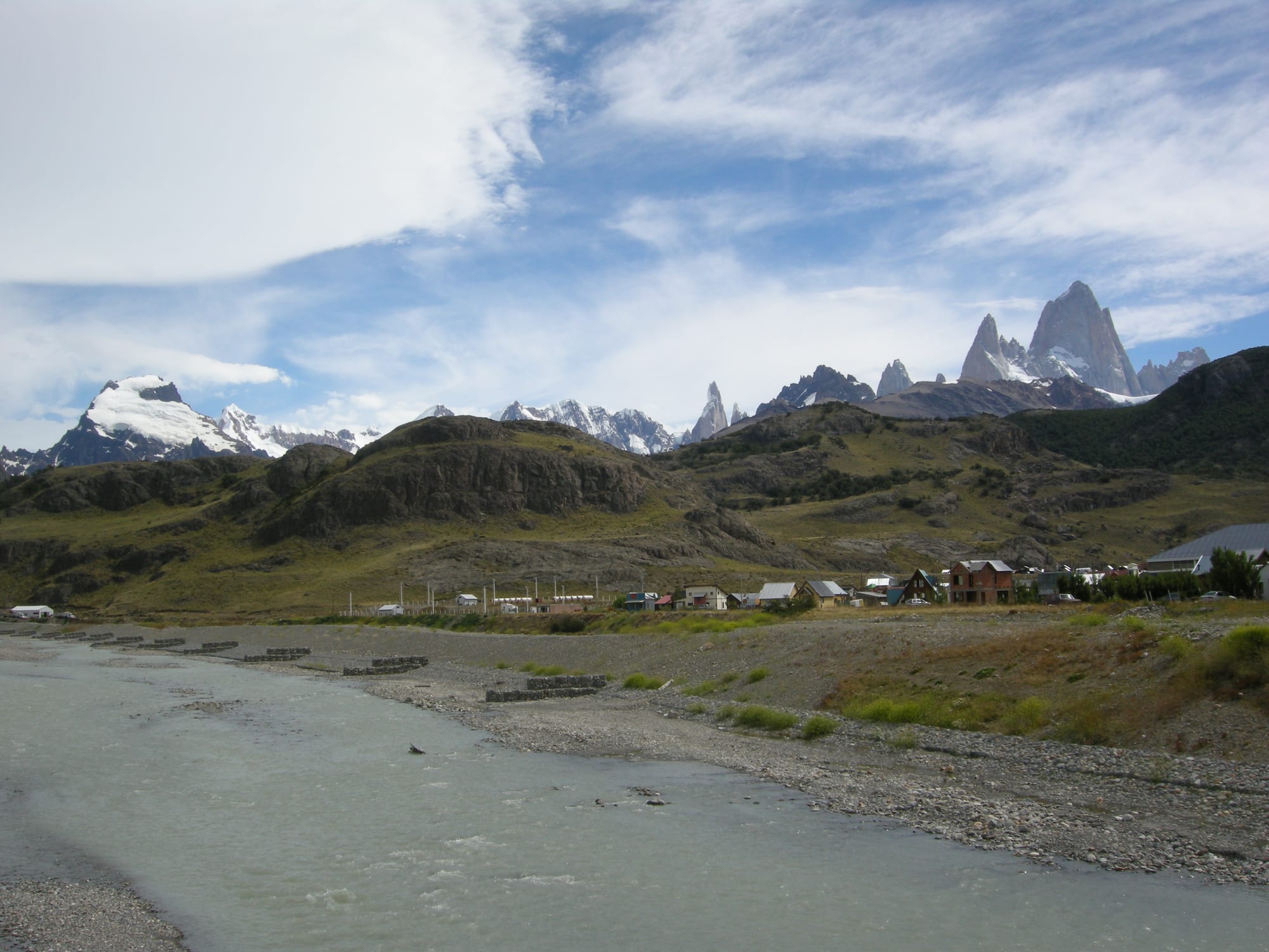
Low houses of a small village beside a grey glacial river, with green hills behind and jagged snow-flecked granite peaks on the skyline

Patagonia, Argentina

El Chaltén

El Chaltén and the Fitz Roy massif, seen from the bridge over the Río Fitz Roy at the entrance to the village. (Gagea / Wikimedia Commons · CC BY-SA 3.0)

A small mountain village on the Río de las Vueltas in the northern sector of Los Glaciares National Park, below the granite spires of Fitz Roy and Cerro Torre. Founded by provincial decree in 1985 to promote settlement in a border zone with nearby areas then disputed with Chile, it has grown into a busy base for trekking and climbing, with trails leaving from its streets.

Neighbourhoods

  • The village centre
    • First-time visitors
    • Best for food
    • Trailheads

    A grid of low houses, hostels, outdoor shops, bakeries, restaurants and bars on a mix of paved and gravel streets, small enough to cross on foot in a quarter of an hour. The main trails to Laguna Torre and Laguna de los Tres start from the village itself.

    Open in Maps
  • The park entrance by the river
    • Information
    • Viewpoints

    The southern approach to the village beside the Río Fitz Roy, where the national park office gives trail and weather information and short paths climb behind it to two easy viewpoints over the village and the valley.

    Open in Maps

Things to do

Trails from the village

  • Laguna de los Trestrail

    The classic long day hike, ending with a steep final climb to a glacial lake at the foot of Monte Fitz Roy; a short extra path looks down on Laguna Sucia below.

    Open in Maps
  • Laguna Torretrail

    A glacial lake about 10 km west of the village, facing the east face of Cerro Torre, usually walked as a day hike from October to April; in late 2025 a decision was taken to reroute the path away from areas at risk of a glacial lake outburst flood.

    Open in Maps
  • Laguna Capritrail

    A smaller lake with a campsite near the trail to Laguna de los Tres, with views of the Fitz Roy massif.

    Open in Maps
  • Mirador de los Cóndores and Mirador de las Águilasviewpoint

    Two short climbs behind the national park office to viewpoints over the village, the river valley and the surrounding peaks.

    Open in Maps
  • Chorrillo del Saltoattraction

    A waterfall near the village, an easy outing for a rest day or bad weather.

    Open in Maps

The peaks

  • Monte Fitz Royviewpoint

    The granite massif the Tehuelche called Chaltén, 'smoking mountain', for the clouds around its summit; renamed by Francisco Moreno in 1877 and first climbed in 1952 by Lionel Terray and Guido Magnone.

    Open in Maps
  • Cerro Torreviewpoint

    A slender 3,128-metre granite needle on the border with Chile, the highest of a chain of four peaks and a famously demanding climb.

    Open in Maps

Short trips from the village

  • Lago del Desiertopark

    A remote lake to the north, at the end of a gravel road of about 37 km along the river valley, for decades the subject of a border dispute with Chile settled in Argentina's favour in 1994.

    Open in Maps
  • Viedma Glacierattraction

    A large valley glacier of the Southern Patagonian Ice Field whose moraine-streaked front ends in Lago Viedma.

    Open in Maps

Eat and drink

Long-standing places and food districts in El Chaltén. Hours, ratings and directions come from your maps app, always current.

El Chaltén classics

  • Village bars and home brewsneighborhood

    Bars around the village pour locally brewed blonde, red and dark beers, and fill with trekkers in the long summer evenings.

    Open in Maps
  • Restaurants of the village centreneighborhood

    Small restaurants and parrillas serving Patagonian lamb, pizza, pasta and hearty plates for hungry hikers.

    Open in Maps
  • Bakeries and trail lunchescafe

    Bakeries and shops sell bread, empanadas, sandwiches and sweets for long days on the trails.

    Open in Maps

Experience El Chaltén

History

The Tehuelche knew the steppe below the mountains and called the great peak Chaltén, "smoking mountain", for the cloud that streams from its summit. In 1877 the explorer Francisco Moreno renamed it after Robert FitzRoy, captain of the Beagle. For most of the 20th century the valley of the Río de las Vueltas was thinly settled, and the border with Chile here was uncertain: Lago del Desierto, to the north, was disputed for decades, and in 1965 a clash between Argentine gendarmes and Chilean police there left a Chilean lieutenant dead.

The village was founded on 12 October 1985, when Santa Cruz governor Arturo Puricelli signed a decree creating it to promote settlement in a border area with sectors still in dispute. Its main promoter was a Gendarmerie commander, Francisco Arrúa, and the head of the National Parks Administration threatened to prosecute the governor for founding a town inside the national park. The founding day was so stormy that the bishop could barely say Mass. In 1994 international arbitration settled the Lago del Desierto dispute in Argentina's favour.

The first settlers were provincial and national public employees, including gendarmes. The census counted just 41 residents in 1991, 371 in 2001 and over 1,600 in 2010, as trekkers came from around the world. In late 2025 a local advisory committee decided to reroute the Laguna Torre trail, around the time a study warned of a growing risk of a glacial lake outburst flood.

Culture & Customs

El Chaltén lives by and for the mountains. It was named Argentina's national capital of trekking, and its culture is that of hikers, climbers and guides: talk of the forecast, early starts, gear shops and bars full of people back from the trail. Fitz Roy and Cerro Torre are celebrated and difficult climbing objectives, and they have drawn climbers since Lionel Terray and Guido Magnone first reached the summit of Fitz Roy in 1952.

As a village founded within living memory, its population has been drawn from elsewhere. Its identity is self-consciously new: it has its own flag and coat of arms, designed to give the community a shared emblem.

The national park shapes everyday customs. Residents and visitors alike are expected to carry out their rubbish, keep to marked trails and respect the rules on fires and camping, and the park visitor centre at the entrance to the village gives trail information to arrivals. Summer evenings are long and sociable, and the local beer culture is a point of pride.

Daily Life

The 2022 census counted about 1,900 people, a figure that had barely grown since 2010 after two decades of rapid expansion. The population swells in summer with seasonal workers and visitors.

The economy is almost entirely tourism: lodgings, restaurants, guiding, transport, outdoor shops and the services that support them. The village sits inside the national park, its homes are low, and many of its roads are gravel and dirt. Snow and ice ring the valley for much of the year, and the Southern Patagonian Ice Field lies just to the west.

Winter is long and quiet. Many businesses close after the trekking season, seasonal workers leave, and those who remain live through short days and snow. El Calafate, with the nearest airport, is about 220 km to the south, and the village's remoteness is part of daily calculation, from the cost of food to the timing of every trip out.

Food

Food in El Chaltén is built for hikers. Bakeries and shops sell bread, cakes, empanadas and sandwiches to carry on the trail, and many visitors self-cater in hostel kitchens or at the campsites. In the evening, restaurants serve hearty plates: pizza, pasta, milanesas and the Argentine parrilla of grilled beef.

Cordero patagónico, Patagonian lamb roasted slowly on an iron cross beside an open fire, is the regional speciality, and stews and soups are welcome after a cold day. The calafate berry, the purple fruit of the steppe shrub, turns up in jams, sauces, liqueurs and ice cream, along with the saying that whoever eats it will return to Patagonia.

Beer is the village drink. Small breweries and bars pour their own blonde, red and dark beers, and a pint after a long trek is a local ritual. Mate is shared at viewpoints and campsites, and hot chocolate warms the walk home when the wind comes down off the ice field.

Planning tools

Budget

El Chaltén is among the most expensive places in Argentina, because almost everything is trucked in over long distances and the season is short. Rooms and meals are dear in January and February, while the free campsites in the park and self-catering keep costs down. Prices in pesos change quickly, so any figure is a guide only.

Daily Budget Midrange
USD 130–240 (guesthouse or hotel, restaurant dinners, a guided glacier or lake trip)
Daily Budget Shoestring
USD 50–85 (hostel bed or campsite, self-catering, hiking on foot)

Book rooms well ahead for January and February, check at the park office for current trail rules and any fees, and budget separately for guided trips.

Best Time to Visit

November to March is the trekking season, when services are open and days are long; January and February are the busiest months. Spring and summer are also the windiest. Many businesses close in winter, when snow covers the trails and the village is very quiet.

Suggested Number of Days

Three or four days gives a fair chance of seeing the peaks clear, since bad weather is common and cloud can hide them for days. Five to seven allow for longer treks, camping in the park and trips beyond the village. Spare days are the best insurance against wind and rain.

First Visit
3–4 days
With Surroundings
5–7 days

Transportation

The village is small and walked end to end, and the main trails start from its streets. Beyond it, gravel roads lead north along the river valley, served by transfers and tours, and many visitors arrive with a hire car from El Calafate.

Fill up and carry supplies before driving north on the gravel roads, and expect strong crosswinds on the open steppe.

Airport & Station Connections

The nearest airport is Comandante Armando Tola International at El Calafate, about 220 km to the south. Buses and shuttles cover the paved road between the two in about three hours, crossing open steppe, and many travellers combine the two places on a single trip.

Walkability

The whole village is walkable in minutes, on paved main streets and gravel and dirt roads, and walking is the point of being here: the trails to Laguna Torre and Laguna de los Tres begin on its edges. Wind, rain and sudden cold are the challenges, and the longer hikes are full days on rough, steep ground.

Safety

Argentina is relatively safe by regional standards, and violent crime against visitors is uncommon. Crime in the village is rare. The dangers are natural: storms that arrive quickly, ferocious wind on exposed ridges, cold and hypothermia, river crossings and, around Laguna Torre, the risk of a glacial lake outburst flood.

Ask at the national park office about the weather and trail conditions, register longer or technical routes, carry layers and waterproofs even in summer, and turn back when the wind rises. Check current official travel advice before travelling.

Climate

A cool, unpredictable subpolar climate, with rain spread over many days and bad weather common. Summer is December to February, with long days, strong winds and frost possible even then. Winters bring moderate snow. Spring and autumn are changeable and generally cold.

Summer
cool and windy, mostly below 18°C by day and below 5°C at night
Winter
cold, averaging around 3°C by day and −4°C at night, with colder spells and snow

Local Customs

El Chaltén is a village of climbers, guides and young workers from all over Argentina, informal and friendly, with life centred on the weather forecast and the trails. Greetings on the path are expected. In the park, everything carried in is carried out, and fires are not permitted outside authorised places.

A tip of around 10 per cent is usual in restaurants. Stay on marked paths, use the campsites provided and carry all rubbish back to the village.

Common Payment Methods

The currency is the Argentine peso. Cards are accepted in many hotels, restaurants and shops, but cash is useful for small purchases and as a reserve in such a remote place, and inflation means prices change often.