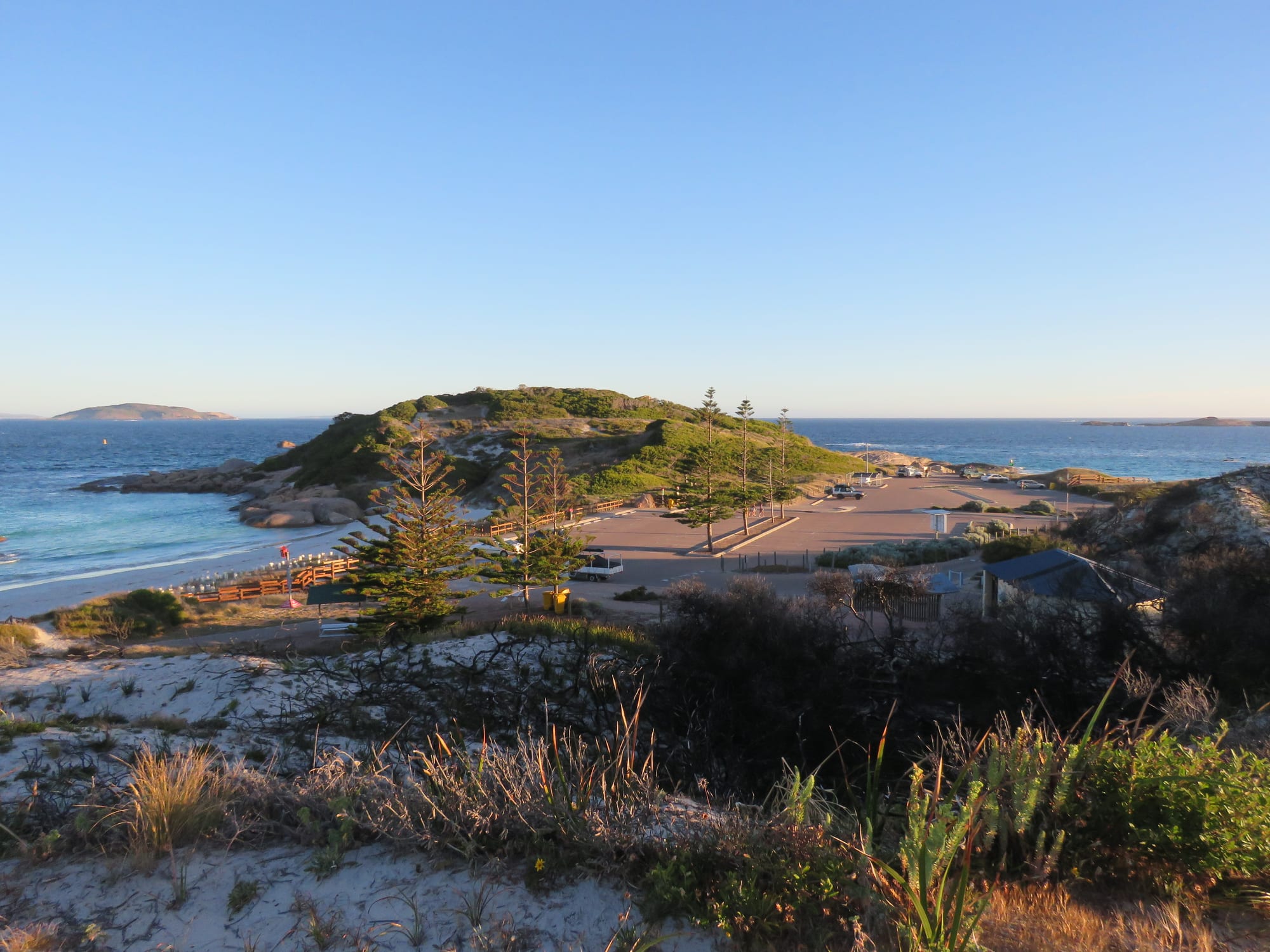
White sand and turquoise water in a bay with a low green headland, a beach car park and islands out on the horizon

Western Australia, Australia

Esperance

Twilight Beach and its bay on the Great Ocean Drive west of Esperance. (Calistemon / Wikimedia Commons · CC BY-SA 4.0)

A port and farming town on the south coast of Western Australia, about 720 kilometres from Perth, set on a bay scattered with granite islands. Named after a French ship that sheltered here in 1792, it ships the district's grain and inland ore and is known for very white beaches, turquoise water and the national parks along the coast to its east.

Neighbourhoods

  • The town centre and foreshore
    • First-time visitors
    • Best for food
    • Close to the beach

    A few flat blocks behind the bay, with the shops, cafés, pubs and museum on and around Dempster and Andrew streets and Norfolk Island pines along the waterfront. The foreshore park, the jetty, a swimming beach and the town's main hotels and caravan parks are all within a short walk.

    Open in Maps
  • The Great Ocean Drive beaches
    • Beaches
    • Swimming and surfing
    • Viewpoints

    West of the town a loop road passes a string of bays — West Beach, Blue Haven, Twilight Beach and the lookouts above them — before turning inland past a wind farm and the salt lakes. Most of the swimming, surfing and sunset watching happens along this stretch rather than in the centre.

    Open in Maps
  • Castletown and the eastern bay
    • Quiet and residential
    • Families
    • Fishing

    The residential suburbs spreading east along the shore of Esperance Bay, with quiet beaches, a shopping centre, sports grounds and the boat harbour at Bandy Creek. It is a few minutes' drive from the centre and the usual base for longer stays and for people with a boat.

    Open in Maps
  • Cape Le Grand and the coast east of town
    • Beaches
    • Camping
    • Walks

    About 55 kilometres east, granite headlands break the coast into bays of very white sand, with campgrounds behind the dunes and a walking track between them. There are no shops, and most visitors either camp or drive out from town for the day.

    Open in Maps

Things to do

Around the town

  • Pink Lakeattraction

    A salt lake beside the coast road west of town, named for a pink colour it no longer shows, a change attributed to shifts in its salinity.

    Open in Maps

Short trips from the town

  • Cape Le Grand National Parkpark

    A park of granite peaks and white bays about 55 kilometres east of the town, with campgrounds behind the dunes and a coastal walk linking its beaches.

    Open in Maps
  • Lucky Baybeach

    A bay in Cape Le Grand National Park named by Matthew Flinders, who sheltered there in his charting of the archipelago in 1802; its sand was tested in 2017 as the whitest in Australia, and kangaroos are often on the beach.

    Open in Maps
  • Recherche Archipelagoattraction

    A group of 105 granite islands and well over a thousand rocks and islets, known locally as the Bay of Isles, with breeding colonies of Australian sea lions and New Zealand fur seals, seabirds, and boat trips out to Woody Island.

    Open in Maps
  • Lake Hillierattraction

    A saline lake on Middle Island, the largest in the archipelago, whose water is pink, though the colour has faded in recent years; it is usually seen from the air on a scenic flight.

    Open in Maps
  • Cape Arid National Parkpark

    A remote park of granite hills and empty beaches east of Cape Le Grand, one of the last strongholds of the western ground parrot.

    Open in Maps

Seasonal events

  • Wildflower seasonSpring

    The sandplain, the heath and the granite outcrops around the town flower in sequence through spring, with banksias, orchids and dozens of species found only on this coast.

  • Southern right whale seasonJuly to October

    Southern right and humpback whales pass along the south coast with their calves and are watched from the beaches, headlands and lookouts near the town.

Eat and drink

Long-standing places and food districts in Esperance. Hours, ratings and directions come from your maps app, always current.

In town

  • Dempster and Andrew streetsneighborhood

    The town's eating is concentrated in the few blocks behind the waterfront — bakeries, cafés, takeaway shops, a couple of pubs and a small supermarket trade among the banks and farm suppliers.

    Open in Maps
  • The Esperance foreshoreneighborhood

    Cafés and fish and chip shops face the bay along the Esplanade, with barbecues and lawns in the foreshore park and the jetty a short walk away.

    Open in Maps

Experience Esperance

History

The coast around Esperance is Wudjari Noongar country, known as Kepa Kurl, and people have lived along it and on the islands, before rising seas cut them off, for many thousands of years. In 1792 two French ships, the Recherche and the Espérance, sheltered from a storm among the islands while searching for the missing expedition of La Pérouse. Both names stuck, to the bay and to the archipelago. Matthew Flinders charted the coast a decade later and named Lucky Bay after finding shelter there in 1802.

European settlement began with the Dempster brothers, who first settled at Esperance Bay in 1864 and ran sheep, cattle and horses on the sandplain. The town's first boom came with gold at Coolgardie and Kalgoorlie in the 1890s, when Esperance became a landing place for prospectors and supplies; it faded when the railway from Perth captured the trade, and for decades the town stayed small. From the 1960s, superphosphate fertilisers carrying trace elements made the poor sandplain soils productive, large areas were cleared for wheat, barley and sheep, and an American syndicate developed farmland in partnership with the state government, drawing wide attention to the district.

The port was rebuilt to ship grain and inland ore, and tourism grew around the beaches and the parks. Two events reached far beyond the district. In 1979 fragments of the falling Skylab space station came down across the shire, and the local council fined the United States $400 for littering, a bill not settled until 2009. On 17 November 2015 bushfires in the farmland north of the town killed four people.

Culture & Customs

Esperance is a farming and shipping town that becomes a holiday town every summer. Families drive down from Kalgoorlie and Perth for the beaches, the caravan parks fill, and the population of the foreshore triples for a few weeks before the town returns to its own business of harvest, freight and football. The two lives sit side by side without much friction.

Life is lived outdoors and on the water. Boats stand on trailers in driveways, the bay and the islands are fished for whiting, salmon and squid, four-wheel drives head out to beaches down the coast, and surfers follow the swell along the ocean-facing bays. The wind is a fact of local life, exploited by kite surfers and by the wind farms on the headlands west of town. Country institutions hold the rest together — the agricultural show, sporting clubs, the volunteer fire brigades that turn out every summer, and the local shows of wildflowers in spring.

Wudjari Noongar people run ranger and land-management programmes along this coast, and the name Kepa Kurl is increasingly used alongside Esperance. Visitors are asked to treat rock shelters, middens and granite outcrops as the heritage sites they are. Manners are the standard country mixture of informality and courtesy, and long distances are taken for granted — a 400-kilometre drive for a football match or an appointment raises no comment.

Daily Life

About 12,000 people live in Esperance, about three-quarters of the population of a shire the size of a small country, which makes it the main service centre for a large stretch of the south coast. Broadacre farming pays for much of it, with wheat, barley, canola and sheep on cleared sandplain country, and the seasons of the district are the farming seasons — seeding in autumn, harvest from late spring into summer.

The port is the other pillar. Grain from the district and iron ore and nickel railed down from the interior are loaded at Esperance, along with fuel and fertiliser coming in. Fishing, government services, a hospital, schools and a growing tourism trade make up the rest of the local economy, and a wind and solar system supplies a large share of the town's electricity.

Daily life has the pattern of a remote regional centre. Freight arrives by road, so groceries cost a little more; specialist medical appointments mean a flight or a long drive to Perth; and school holidays and harvest set the rhythm of the year more than the calendar does. Housing has become expensive and hard to find, as it has across regional Australia. Dryland salinity and the loss of native vegetation from decades of clearing are long-running problems, and bushfire preparation is a normal part of summer.

Food

Esperance eats from the farm and the bay. Rock lobster, abalone and sardines are taken commercially off this coast, while Australian salmon, herring, whiting, snapper and squid are caught from the beaches, the rocks and small boats; fish and chips on the foreshore is a local habit. Lamb and beef come from the district's own paddocks, and the wheat and barley grown around the town end up in bread and beer, including beer brewed locally from barley malted in the district.

The choice of places to eat is that of a country town of its size. Bakeries and cafés on the main streets serve pies, sausage rolls and coffee that would not embarrass Perth; the pubs do counter meals; and there are takeaways, a pizza shop or two and a small supermarket. In the summer holidays the foreshore stalls and caravan-park kiosks open, and everything is busier for six weeks.

Local produce turns up at markets and roadside honesty boxes — honey, eggs, olives, stone fruit and vegetables in season. Wine is not made here in any quantity; the lists lean on the Great Southern and Margaret River, several hundred kilometres west. Campers heading east into the parks buy everything in town first, since there are no shops beyond the edge of the farmland.

Planning tools

Budget

Esperance is cheaper than the mining towns of the north and about the same as other regional centres in the south. Accommodation is the main cost and is tight over the Christmas and January school holidays, when families arrive from Perth and the Goldfields. National park entry, fuel for the drives east and west, and a boat trip to the islands are the other expenses; the beaches and lookouts are free.

Daily Budget Midrange
USD 170–300 (motel room or holiday unit, restaurant meals, a hire car, a park pass or a boat trip)
Daily Budget Shoestring
USD 70–120 (campsite or backpacker bed, self-catering, a share of fuel, swimming and walking)

Book rooms and campsites well ahead for January, and buy fuel and groceries in town rather than at the roadhouses on the way in.

Best Time to Visit

Late spring and early autumn suit the town best. October to December brings wildflowers, long days and water warm enough to swim in, and March to April is settled and quiet after the holidays. January is hot, windy and busy. Winter is cool, green and wet, with whales along the coast and the beaches almost empty.

Suggested Number of Days

Two or three days cover the town, the coast road west and one of the national parks to the east. Four to six allow the further parks, a boat trip among the islands and time lost to wind or rain, which can shut the water down for a day at a time.

First Visit
2–3 days
With Surroundings
4–6 days

Transportation

A car is needed. There is no useful public transport, the coast road west is a scenic loop, and the national parks lie 55 to 120 kilometres east on sealed roads with gravel access tracks at the end. Hire cars are available in town and at the airport, and a few tour operators run day trips to the parks and boat trips to the islands. The flat town itself is easy on a bicycle.

Kangaroos and emus are on the roads at dawn and dusk, gravel tracks need lower speeds, and beach driving calls for a four-wheel drive with reduced tyre pressure.

Airport & Station Connections

Esperance Airport is about 20 kilometres from town and takes flights from Perth of under two hours. By road the town is about 720 kilometres from Perth, usually driven in a day or split at Hyden or Ravensthorpe, and around 400 kilometres south of Kalgoorlie on the Coolgardie–Esperance Highway. Coaches run from Perth, and many visitors arrive on a longer loop through the Wheatbelt or the Goldfields.

Walkability

The centre is flat and small enough to cross in ten minutes, and a path runs along the foreshore past the jetty and the swimming beach. Beyond that the town spreads thinly along the bay and the good beaches are several kilometres west, so most visits involve driving or cycling. Wind off the Southern Ocean is a constant, and there is little shelter on the coast road.

Safety

The town is safe, and the risks are natural. Beaches are unpatrolled outside the main town beach in summer, with strong rips and cold water; the south coast has had shark attacks, and local advice about where to swim is worth following. Summer brings a serious bushfire risk in the surrounding farmland and scrub, and roads out of town are long, empty and busy with wildlife at dawn and dusk.

Swim between the flags where a beach is patrolled, check fire danger ratings and total fire bans in summer, carry water on park walks, and leave a route plan with someone before remote drives. Check current official travel advice before travelling.

Climate

A Mediterranean climate cooled by the Southern Ocean, milder in summer than Perth and wetter in winter, with wind almost every day. In the southern hemisphere summer falls in December to February and winter in June to August, and rain can arrive in any season on a cold front.

Summer
warm and windy — December to February days are usually around 26°C, with occasional hot spells above 35°C when the wind turns north, and cool nights
Winter
cool and wet — June to August days are around 17°C, with showers, strong westerlies and a green landscape

Local Customs

This is a country town with holiday-town habits, and manners are informal. Tipping is not expected. Drivers acknowledge one another on quiet roads, farm gates are left as they are found, and stock and machinery have right of way on rural roads. Dogs are not allowed in the national parks, and dune fences and boardwalks are there to hold the sand in place. The district is Wudjari Noongar country, known as Kepa Kurl, and its heritage sites are protected.

Take all rubbish out of the national parks, stay off the dunes and off the roped areas around nesting birds, and leave Aboriginal sites, rock shelters and artefacts untouched.

Common Payment Methods

The currency is the Australian dollar. Cards and contactless payment are taken in the shops, cafés, fuel stations and park kiosks, and there are cash machines in the town centre. Small campgrounds, market stalls and honesty boxes on farm gates work in cash, and there is no mobile coverage through much of the country east of the parks.