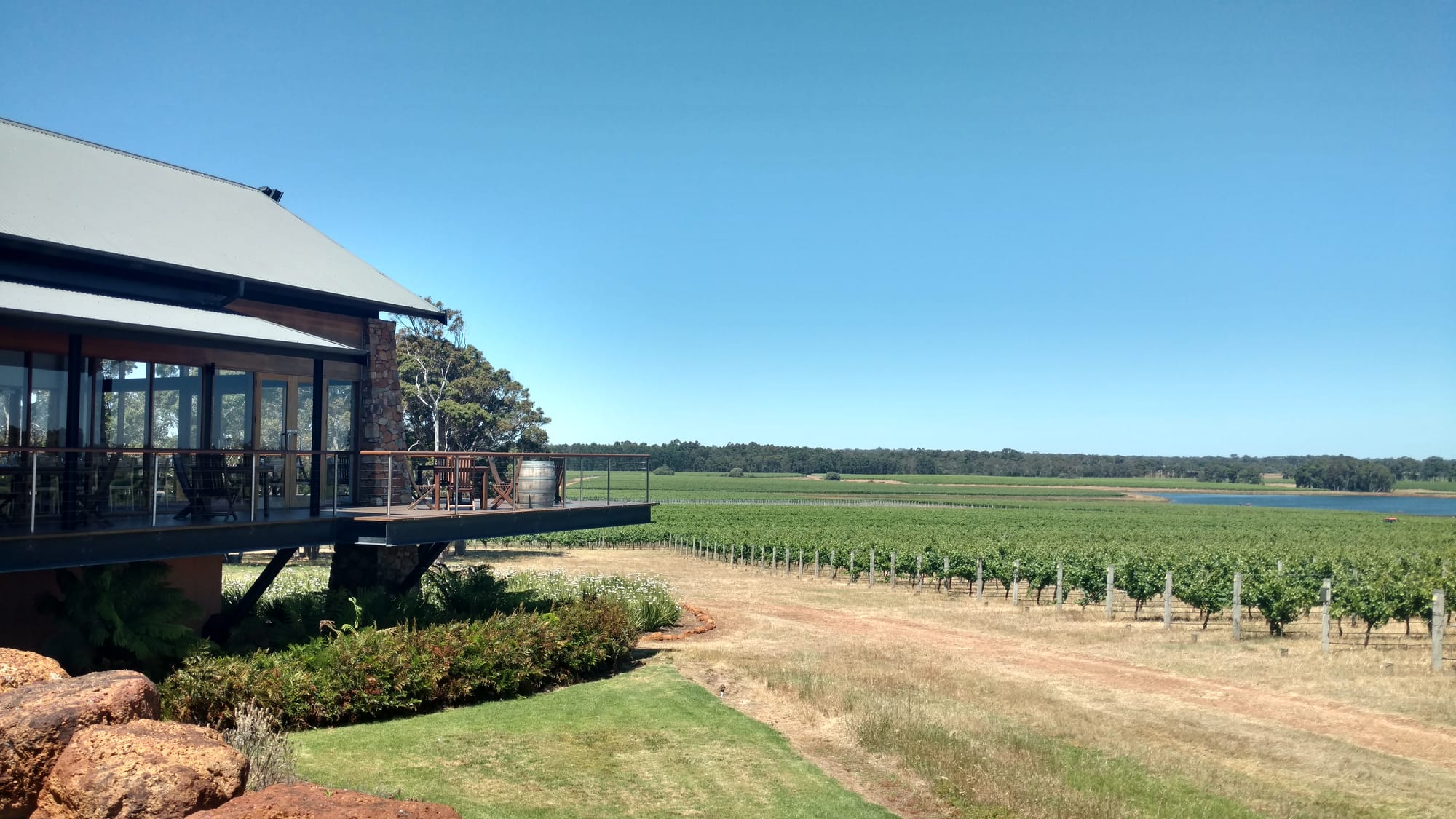
A timber cellar-door building with a deck and a wine barrel above long rows of vines under a clear blue sky

Western Australia, Australia

Margaret River

A cellar-door terrace above the vine rows in the Margaret River wine region. (Lasthib / Wikimedia Commons · CC BY-SA 4.0)

A small town in the far south-west of Western Australia, some 277 kilometres south of Perth, on the river of the same name about nine kilometres inland from the Indian Ocean. Dairy and timber country until the first commercial vines went in during the 1960s, it is now the centre of Australia's best-known cool-maritime wine region and of a serious surf coast.

Neighbourhoods

  • The town centre
    • First-time visitors
    • Best for food
    • Close to shops

    A few blocks of Bussell Highway holding the supermarkets, bakeries, surf shops, galleries and most of the town's restaurants and bars, with the river and its walking paths at the southern end. Nearly everything in town is within ten minutes on foot.

    Open in Maps
  • Prevelly and Gnarabup
    • Beaches
    • Surfing
    • Sunsets

    The coastal settlements about ten kilometres west, where the river meets the sea. Prevelly sits above the surf breaks at Surfers Point, Gnarabup has a sheltered bay, a boat ramp and a café on the sand, and both have holiday houses rather than a village centre.

    Open in Maps
  • Cowaramup and Witchcliffe
    • Wineries
    • Quiet and residential
    • Villages

    Two small settlements on the highway north and south of the town, each a handful of shops and a pub. Cowaramup, whose Wardandi name means purple-crowned lorikeet, sits among the vineyards, while Witchcliffe is the turn-off for the caves and the southern forest.

    Open in Maps
  • Gracetown
    • Beaches
    • Quiet
    • Surfing

    A small holiday settlement of houses stepped above Cowaramup Bay, about 20 kilometres north-west. It has a general store, a sheltered swimming beach and a set of well-known reef breaks within walking distance along the cliffs.

    Open in Maps
  • Caves Road and Wilyabrup
    • Wineries
    • Quiet and residential
    • Walks

    The road that runs parallel to the coast through the heart of the vineyards, with most of the region's cellar doors, breweries and food producers strung along it. Wilyabrup, at its northern end, holds the oldest and best-known estates. Staying here means driving everywhere.

    Open in Maps

Things to do

Caves, forest and walks

  • Mammoth Caveattraction

    A large limestone cave 21 kilometres south of the town, walked on a boardwalk with an audio guide, holding the fossil bones of extinct animals in its floor deposits.

    Open in Maps
  • Lake Caveattraction

    Reached down a long staircase into a collapsed doline, a chamber of fine formations around a still lake, seen on guided tours.

    Open in Maps
  • Leeuwin-Naturaliste National Parkpark

    The park that protects most of the coastal strip between the two capes, including the tall karri trees of the Boranup Forest, granite headlands, wildflowers in spring and the limestone ridge the caves are cut into.

    Open in Maps
  • Cape to Cape Tracktrail

    A walking track of about 120 kilometres along the coast from Cape Naturaliste to Cape Leeuwin, usually walked in day sections from the beaches near the town.

    Open in Maps

Beaches and surf

  • Surfers Pointbeach

    The headland at the river mouth below Prevelly, also called Margarets Main Break, the reef wave that made the town's name among surfers and the site of its professional contest.

    Open in Maps
  • Cowaramup Baybeach

    The bay at Gracetown, sheltered enough for family swimming at its northern end while a string of reef breaks works along the cliffs on either side.

    Open in Maps
  • Hamelin Baybeach

    A wide sheltered bay about 30 kilometres south, with the remains of a timber jetty built in 1882 for the Davies timber mills, shipwrecks offshore and the Boranup sands stretching north towards the river mouth.

    Open in Maps

Short trips from the town

  • Cape Leeuwin Lighthouselandmark

    A lighthouse of local stone opened in 1895 at the continent's south-western corner, where the Indian and Southern oceans are said to meet.

    Open in Maps
  • Augustaattraction

    A quiet town at the mouth of the Blackwood River about 45 kilometres south, with a long inlet, a whale-watching season in winter and Jewel Cave, one of six caves open to visitors in the area, nearby.

    Open in Maps
  • Ngilgi Caveattraction

    A cave at Yallingup, at the northern end of the same ridge, long known to the Wardandi people and first entered by a European in 1899, named for a figure in Wardandi Noongar story.

    Open in Maps
  • Busselton Jettylandmark

    A timber jetty stretching almost two kilometres into Geographe Bay at Busselton, with a small train along it and an underwater observatory at the end.

    Open in Maps

Seasonal events

  • Margaret River ProApril or May

    A professional surfing contest on the World Surf League tour, held at Surfers Point near the river mouth every year since 1985.

  • Leeuwin Estate Concert SeriesFebruary

    An open-air concert on a winery lawn south of the town, held since the London Philharmonic Orchestra played there in 1985 and known for touring orchestras and international singers.

Eat and drink

Long-standing places and food districts in Margaret River. Hours, ratings and directions come from your maps app, always current.

Cellar doors

  • Vasse Felixrestaurant

    The region's first commercial vineyard, planted in 1967 at Wilyabrup, with a tasting room, an art gallery and a restaurant looking over the vines.

    Open in Maps
  • Leeuwin Estaterestaurant

    A large estate in karri forest south of the town, known for its chardonnay, its concert lawn and a dining room among the trees.

    Open in Maps
  • Wilyabrup cellar doorsneighborhood

    The cluster of long-established estates in the valleys north of the town, where most of the region's famous cabernet and chardonnay is grown and nearly every gate has a tasting room.

    Open in Maps

In town

  • Margaret River Farmers Marketmarket

    A Saturday-morning producers' market on the edge of the town centre, with local beef and pork, marron, avocados, berries, cheese, bread, olive oil and coffee.

    Open in Maps
  • Bussell Highwayneighborhood

    The main street doubles as the eating strip, with bakeries, pie shops, cafés, a couple of pubs and restaurants that cook regional produce and pour local wine by the glass.

    Open in Maps

Breweries and the coast

  • Caves Road producersneighborhood

    Breweries, distilleries, a chocolate factory, cheese makers, an olive grove and a venison farm are spaced along the road between the vineyards, most with a tasting counter and a lawn.

    Open in Maps
  • Gnarabupneighborhood

    The beach café and kiosk above the bay at Gnarabup, the usual place for breakfast or a cold drink after a swim, with tables looking straight down at the water.

    Open in Maps

Experience Margaret River

History

This is Wardandi Noongar country — the name is usually translated as the ocean people — and the limestone caves along the ridge hold some of the oldest evidence of human life in the south-west, with occupation at Devil's Lair near Witchcliffe dated to more than 40,000 years ago. Noongar families moved between the coast, the river and the forest with the seasons, and the caves and springs remain significant places.

Europeans came south from the Swan River Colony in the 1830s. The Bussell family settled the Vasse and Blackwood districts, built homesteads at Ellensbrook and Wallcliffe near the river mouth, and gave their name to the highway; the river itself was named in 1831, and is thought to commemorate Margaret Whicher, a cousin of John Garrett Bussell. For a century the district lived on cattle, dairying and timber, cutting jarrah and karri for railway sleepers and piles, and a railway reached the town in the 1920s.

The Group Settlement Scheme of the same decade placed hundreds of inexperienced British families on small blocks of cleared forest around Margaret River. Many walked off within a few years, and the abandoned blocks later became vineyards. In the 1960s the agronomist John Gladstones identified the district as well suited to wine grapes, the first commercial vines went in at Vasse Felix, founded at Wilyabrup by Tom Cullity in 1967, and within twenty years the town had changed completely. Surfers had found the reef breaks at the river mouth by the 1960s, and professional contests have been held there since.

Culture & Customs

Two cultures share the town, and they overlap more than outsiders expect. One is the surf culture of the coast, centred on the reefs at the river mouth and along the cliffs towards Gracetown, where the breaks are powerful, the water is cold and the line-up has its own hierarchy and etiquette. The other is the wine and food culture of the valleys inland, built by a small number of families since the 1960s and now an industry of cellar doors, restaurants, breweries and producers.

Around both has grown a large community of artists, potters, woodworkers and musicians, many of them originally from Perth. The Saturday farmers market is the week's social fixture, and the calendar runs on the surfing contest in autumn, a concert on a winery lawn in February and a run of long lunches through the winter.

Manners are rural and casual: a wave from the driver of an oncoming ute on a back road, gates left as they were found, bare feet in the bakery. Wardandi Noongar heritage is increasingly explained on its own terms, with Aboriginal-guided walks in the caves and along the coast and dual names on signs. The region takes its fire seasons, its whale seasons and its vintage dates as the real calendar.

Daily Life

Some 14,000 people live in the surrounding shire, about half of them in the towns of Margaret River and Augusta and the rest spread between the coastal settlements and a scatter of small inland villages. The population swells several times over in the summer and Easter holidays, and a large share of the housing is holiday accommodation, which keeps rents high and long-term rentals scarce.

Wine, tourism and agriculture are the economy. More than two hundred wineries operate in the region, alongside beef and dairy farms, avocado and olive groves, marron ponds and what is left of the timber industry. Vintage, from about February to April, brings in seasonal pickers and cellar hands, many of them travellers on working holidays, and hospitality employs a large part of the town year-round.

Daily life is that of a small country town with an unusually good restaurant list. Children travel to the local schools by bus, the hospital handles routine care while anything serious goes to Bunbury or Perth, and the three-hour drive to the city is a familiar chore. Summer brings fire preparation — cleared firebreaks, packed evacuation bags, days of watching the wind — and the recurring public arguments concern housing, water, clearing for vineyards and how many visitors the coast can take.

Food

The wine comes first. The region grows a few per cent of Australia's crop but a large share of its premium bottles, and it is known above all for cabernet sauvignon, for chardonnay, and for the crisp blends of semillon and sauvignon blanc that locals drink on a hot afternoon. The region has no official subregions, but the six proposed by John Gladstones run from Yallingup in the north to Karridale in the south, with the oldest estates in the gravelly valleys of Wilyabrup.

The food follows the farms. Margaret River beef and free-range pork, dairy from the old dairying flats turned into cheese and yoghurt, marron from freshwater ponds, venison, avocados, berries, olive oil and honey all appear at the Saturday market and on menus within a few kilometres of where they were grown. From the sea come western rock lobster, dhufish and abalone, and the roadside signs for fresh crayfish in season are worth following.

Producers have made a tourist attraction of themselves along Caves Road, where a chocolate factory, cheese rooms, a brewery or two, distilleries making gin from local botanicals and a bakery are spaced between the vineyards. In town, the bakeries and pie shops on Bussell Highway feed surfers at dawn, and the restaurants stay open later than the size of the place would suggest.

Planning tools

Budget

Margaret River is an expensive small town. Accommodation is the largest cost and rises steeply in the school holidays, restaurants are priced for visitors, and a hire car is effectively compulsory. Tasting fees are common at cellar doors. The beaches, the forest, the walking tracks and the lookouts are free, and caravan parks, campsites and hostels keep a budget trip possible.

Daily Budget Midrange
USD 200–350 (chalet or small hotel, restaurant meals, tastings and a cave visit, a hire car)
Daily Budget Shoestring
USD 90–150 (hostel bed or campsite, self-catering, a share of car hire, beaches and forest walks)

Book rooms months ahead for Easter, Christmas and the surfing contest, and arrange a driver or a tour for any day built around tastings, as drink-driving is heavily policed.

Best Time to Visit

Spring, from September to November, brings wildflowers, whales off the coast and mild dry days; autumn, from March to May, is warm and settled and coincides with the grape harvest. Summer, December to February, is dry, bright and very busy with Western Australian holidaymakers. Winter is wet and green, with the biggest surf, open fires and the quietest cellar doors.

Suggested Number of Days

Two or three days are enough for the town, the coast and a stretch of the wine country. Four or five allow the southern end of the cape and the inland forest as well. Everything is spread along two parallel roads, so driving time and a relaxed pace matter more than a long stay.

First Visit
2–3 days
With Surroundings
4–5 days

Transportation

A car is close to essential. Two roads run north to south through the region — Bussell Highway through the towns and Caves Road nearer the coast — and the vineyards, caves and beaches lie along them, from a few kilometres to about forty from the town centre. Coaches run from Perth and Bunbury to the town, but there is no local bus network to speak of. Wine tours provide a driver, taxis are few, and the Wadandi Track, a rail trail on an old timber line, links the town with the villages to the north for cyclists and walkers.

Watch for kangaroos on the roads at dawn and dusk, and expect gravel on the minor routes to the coast.

Airport & Station Connections

Margaret River is about 270 kilometres south of Perth, a drive of a little over three hours on the Forrest and Bussell highways, and coaches take around five. Busselton Margaret River Airport, roughly 50 kilometres north, handles some interstate flights, but most visitors fly into Perth and drive. Bunbury, on the rail line from Perth, is about 100 kilometres north-east.

Walkability

The town centre is small and flat, and everything in it — shops, cafés, the market site and the river path — is within a ten-minute walk. Outside the centre footpaths thin out quickly, and the vineyards, caves and beaches are far too spread out to reach on foot. Walking here means the coastal track, the forest trails or the rail trail rather than getting about town.

Safety

Crime is low and the risks are outdoor ones. The surf breaks near the river mouth are powerful and best left to experienced surfers, and rip currents run on the open beaches, few of which are patrolled. Shark attacks have occurred along this coast, and warnings and beach closures are issued. Summer brings a high bushfire risk in the forest and vineyards, and a fire destroyed houses near the coast in 2011. Kangaroos on the roads at dusk are the commonest cause of accidents.

Swim at patrolled beaches where there are any, check fire warnings and shark notices in summer, carry water on the coastal track, and drive slowly at dawn and dusk. Check current official travel advice before travelling.

Climate

A mild Mediterranean climate, cooler and much wetter than Perth and moderated by the ocean on three sides. Summer in the southern hemisphere runs from December to February and is warm, dry and breezy; nearly all the rain falls between May and September, when fronts come in off the Southern Ocean. Frost is rare and snow unknown.

Summer
warm and dry, generally about 14–28°C, with a strong afternoon sea breeze
Winter
cool and wet, roughly 8–17°C, with long rainy spells and big ocean swells

Local Customs

This is Wardandi Noongar country, and Wardandi names and guides are part of the caves and coastal tours. The town is informal, dressed for the beach or the paddock, and first names are used everywhere. Some cellar doors ask for a tasting fee, spitting rather than swallowing is normal at a tasting, and turning up with a designated driver is expected rather than remarked on. Surf etiquette at the breaks is taken seriously by local surfers.

Tipping is not expected in Australia. Leave farm gates as they were found, keep dogs out of the national park, and observe total fire bans in summer, when even a barbecue may be prohibited.

Common Payment Methods

The currency is the Australian dollar. Cards and contactless payment are taken at cellar doors, shops and restaurants, and cash machines are on Bussell Highway in the town centre. Some farm gates and market stalls prefer cash, and mobile coverage is patchy in the forest and on the back roads, so a little cash is worth carrying.