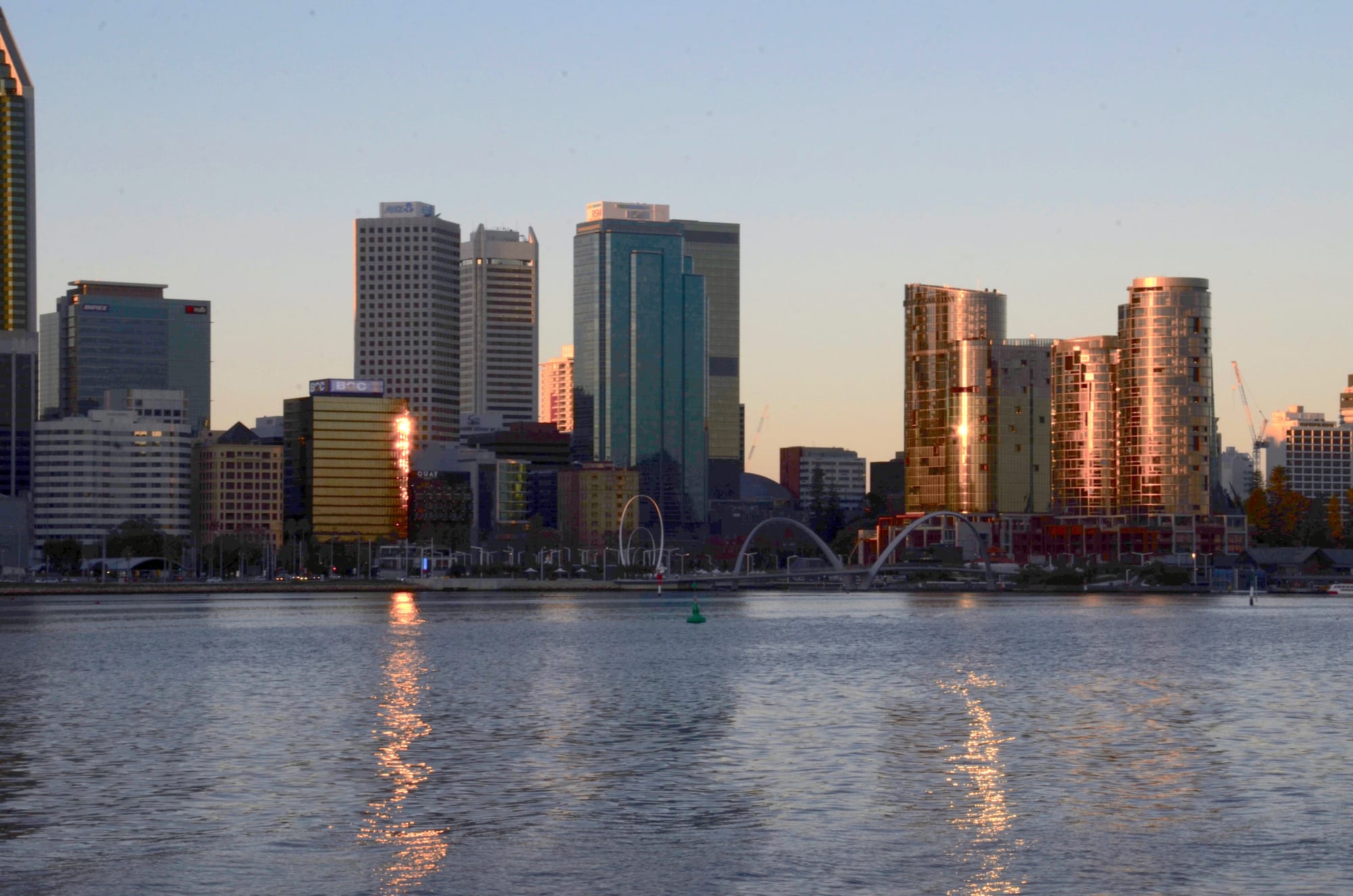
Perth's high-rise towers catching low sunset light across the Swan River, with the arched Elizabeth Quay footbridge below them

Western Australia, Australia

Perth

The Perth skyline and the Elizabeth Quay footbridge seen across the Swan River from South Perth. (JarrahTree / Wikimedia Commons · CC BY 2.5 au)

The capital of Western Australia, spread along the Swan River and the Indian Ocean coast and one of the most isolated large cities in the world. Founded as the Swan River Colony in 1829 on Whadjuk Noongar country, it was transformed by gold in the 1890s and by mining booms since, and now holds about 2.3 million people, most of its state's population.

Neighbourhoods

  • Perth city centre
    • First-time visitors
    • Close to public transport
    • Shopping

    The compact business district between the railway and the river, built around St Georges Terrace and the pedestrian malls of Hay and Murray streets. Most of the city's hotels are here, along with arcades, small laneway bars, the riverside development at Elizabeth Quay and free buses and trains within the central zone.

    Open in Maps
  • Northbridge
    • Nightlife
    • Best for food
    • Museums

    Immediately north of the railway, this is where Perth goes out. William and James streets hold the city's densest run of Asian and Italian restaurants, pubs and live music rooms, and the Perth Cultural Centre at its southern edge gathers the state museum, the art gallery and the state library.

    Open in Maps
  • Mount Lawley and Highgate
    • Best for food
    • Bars
    • Historic homes

    A leafy inner suburb north-east of the centre with streets of Federation and California bungalow houses. Beaufort Street runs through it as a strip of cafés, wine bars, bookshops and restaurants, and the theatre and cinema at its city end keep it busy on weeknights.

    Open in Maps
  • Subiaco
    • Quiet and residential
    • Cafés
    • Close to public transport

    A well-to-do older suburb a few minutes west by train, with restored workers' cottages and a shopping and dining strip along Rokeby Road, its main street since the 1890s, and Hay Street. Subiaco Oval, once the state's largest stadium, stood at its eastern end and that site is being redeveloped.

    Open in Maps
  • Leederville
    • Cafés
    • Bars
    • Students

    A small, busy strip on Oxford Street just north of the city, known for breakfast and coffee, bars and small venues. It is close to the parkland around Lake Monger, less than five kilometres from the centre, and sits on the northern railway line.

    Open in Maps
  • Fremantle
    • Historic district
    • Best for food
    • Markets

    The port at the mouth of the Swan, half an hour south-west by train, kept largely intact since the gold-rush years. Its West End is a run of 19th-century stone and brick streets, and the markets, the fishing boat harbour, the convict-built prison and a long café strip give it a character quite separate from the city.

    Open in Maps
  • Cottesloe and the beach suburbs
    • Beaches
    • Sunsets
    • Quiet and residential

    The string of suburbs along the Indian Ocean between the city and Fremantle, of which Cottesloe is the best known, with a broad white beach, Norfolk Island pines and a hotel above the sand. Scarborough and City Beach further north have surf, promenades and pools.

    Open in Maps

Things to do

Famous landmarks

  • Kings Park and Botanic Gardenpark

    A 400-hectare plateau of bushland and botanic gardens above the river and the city, with the State War Memorial, the Lotterywest Federation Walkway through the treetops and the classic view over the skyline.

    Open in Maps
  • Elizabeth Quayattraction

    An inlet cut into the riverbank in 2016 to reconnect the city to the water, with a looping pedestrian bridge, a ferry jetty, sculptures and a waterfront of bars and towers.

    Open in Maps
  • The Bell Towerlandmark

    A glass and copper spire on the riverfront housing twelve historic bells from St Martin-in-the-Fields in London, a ring traced to before the 14th century, rung for visitors from an open viewing floor.

    Open in Maps
  • Perth Mintmuseum

    A limestone building of 1899 that still refines Australian gold, with a working melt, the world's largest gold coin and displays of nuggets from the state's goldfields.

    Open in Maps
  • London Courtlandmark

    A narrow mock-Tudor shopping arcade of 1937 between St Georges Terrace and Hay Street Mall, with mechanical clocks at either end.

    Open in Maps
  • His Majesty's Theatrelandmark

    An Edwardian baroque theatre of 1904 in the city centre, home to the state opera and ballet companies and the last theatre of its kind in the country still in use.

    Open in Maps

Museums and galleries

  • WA Museum Boola Bardipmuseum

    The state museum in the Perth Cultural Centre, reopened in 2020 behind its old buildings, covering Western Australian land, life, Aboriginal history and the state's own story.

    Open in Maps
  • Art Gallery of Western Australiamuseum

    The state collection, strong on Australian and Indigenous art, in a 1979 building beside the museum with a rooftop terrace over the city.

    Open in Maps
  • WA Maritime Museummuseum

    On the harbour at Fremantle, a sail-shaped building holding Australia II, the yacht that won the America's Cup in 1983, alongside pearling luggers and a submarine outside.

    Open in Maps
  • Fremantle Prisonlandmark

    A convict-built limestone gaol of the 1850s, in use until 1991 and now World Heritage-listed as part of the Australian Convict Sites, with tours of the cells, the tunnels beneath and the yards.

    Open in Maps

Beaches, parks and the river

  • Cottesloe Beachbeach

    Perth's best-known beach, a wide arc of white sand between groynes with a pine-shaded terrace above it and sunsets straight into the Indian Ocean.

    Open in Maps
  • Scarboroughbeach

    A surf beach 14 kilometres north-west of the centre, rebuilt with a promenade, skate park and pool, and the most reliable place near the city for waves and wind sports.

    Open in Maps
  • City Beachbeach

    A family beach backed by grass and a low headland, closer to the centre than most and quieter than Cottesloe or Scarborough.

    Open in Maps
  • The Swan Riverattraction

    Derbarl Yerrigan to the Noongar, the wide river that the city is built around, used for ferries, sailing, dolphin watching and the paths that follow both banks.

    Open in Maps
  • Perth Zooattraction

    An old zoo in South Perth, reached by ferry across the river, known for its Australian bushwalk, nocturnal house and breeding programmes for numbats and other native animals.

    Open in Maps

Sport and nights out

  • Perth Stadiumattraction

    The 60,000-seat stadium at Burswood, opened in 2018 for Australian rules football and cricket, reached on foot from the city over the Matagarup Bridge.

    Open in Maps
  • RAC Arenaattraction

    The city's indoor arena, an angular building on the western edge of the centre used for basketball, tennis and concerts.

    Open in Maps
  • WACA Groundattraction

    The Western Australian Cricket Association's ground in East Perth, opened in 1893 and the state's Test cricket venue from 1970 until the larger stadium opened across the river.

    Open in Maps

Short trips from the city

  • Rottnest Islandattraction

    Wadjemup to the Noongar, a car-free island of bays and salt lakes about 18 kilometres west of Fremantle, reached by fast ferry, explored by bicycle and home to the quokka.

    Open in Maps
  • Fremantleneighborhood

    The old port at the river mouth, with its markets, breweries, museums, prison and West End streetscape, half an hour from the city by train.

    Open in Maps
  • Swan Valleyattraction

    A wine region on the upper Swan about 20 kilometres north-east, with cellar doors, breweries, citrus orchards and the colonial town of Guildford at its southern end.

    Open in Maps
  • John Forrest National Parkpark

    Western Australia's first national park, proclaimed in 1900, in the Darling Range east of the city, with granite outcrops, a seasonal waterfall, wildflowers in spring and a walking trail along an old railway alignment.

    Open in Maps

Seasonal events

  • Fringe WorldJanuary and February

    A month of comedy, cabaret and circus in tents, courtyards and pop-up venues across the city, at the heart of its summer festival season.

  • Perth FestivalFebruary and March

    Australia's oldest annual international arts festival, founded in 1953, with theatre, music, film and free outdoor events across the city and the river.

  • Sculpture by the SeaMarch

    An open-air exhibition of sculpture set along Cottesloe Beach and the lawns above it, free to walk through.

  • Kings Park FestivalSeptember

    A month of wildflower displays, guided walks and music in Kings Park during the state's spring wildflower season.

  • Perth Royal Showlate September and early October

    The state agricultural show at Claremont, with livestock and produce competitions, sideshows and showbags.

Eat and drink

Long-standing places and food districts in Perth. Hours, ratings and directions come from your maps app, always current.

Food streets and districts

  • Northbridgeneighborhood

    William and James streets hold Perth's densest concentration of Vietnamese, Chinese, Malaysian and Italian restaurants, with pho and laksa kitchens, roast duck windows, dumpling houses and late-opening bars.

    Open in Maps
  • Albany Highway, Victoria Parkneighborhood

    A long strip just across the river from the centre, lined with Indian, Thai, Vietnamese, Japanese and Middle Eastern restaurants and some of the city's best-value eating.

    Open in Maps
  • Beaufort Street, Mount Lawleyneighborhood

    The inner north's café and wine-bar strip, good for long breakfasts, small plates and a drink before a show at the theatre on the corner.

    Open in Maps
  • South Terrace, Fremantleneighborhood

    Known as the Cappuccino Strip, a run of pavement cafés and Italian-founded coffee houses through the old port, busiest on weekend mornings.

    Open in Maps

Markets, breweries and wine

  • Fremantle Marketsmarket

    A market hall of 1897 near the Fremantle station, with fruit and vegetable stalls, a food hall of cheap hot food from a dozen countries, and craft and clothing stalls alongside.

    Open in Maps
  • Fremantle Fishing Boat Harbourneighborhood

    The working fishing harbour where the trawlers tie up, ringed by fish and chip shops, seafood restaurants and a brewery in an old waterfront shed.

    Open in Maps
  • Swan Valleyneighborhood

    Cellar doors, breweries, distilleries, chocolate and honey makers and roadside fruit stalls spread along a loop of road less than an hour from the city centre.

    Open in Maps

Experience Perth

History

The Swan River is Derbarl Yerrigan to the Whadjuk Noongar, and the ground where the city stands, Boorloo, was part of a landscape lived in for tens of thousands of years. Captain James Stirling surveyed the river in 1827, and the Swan River Colony was founded in June 1829 — a free settlement, unlike the convict colonies of the east, and named after Perth in Scotland.

It grew slowly and painfully. Sandy soils, isolation and a shortage of labour almost broke it, and Noongar people were pushed off the river flats, with violence through the 1830s that included the killings at Pinjarra. The colony eventually asked for convicts, who were transported from 1850 to 1868 and built much of what survives from the period, including Fremantle Prison, Government House and the Perth Town Hall.

Gold changed everything. The strikes at Coolgardie and Kalgoorlie in the 1890s multiplied the colony's population within a decade and paid for C. Y. O'Connor's harbour at Fremantle and the pipeline that still carries water inland to the goldfields. Perth became a city of trams, terraces and iron-roofed cottages, and after the Second World War a city of suburbs, filled by British and southern European migrants.

Mining booms in the 1960s and again from about 2004 rebuilt the skyline and made the state rich. In 1962 the city left its lights burning for John Glenn's orbit and was called the City of Light; in 1986 and 1987 it hosted the America's Cup off Fremantle, where the American challenger won the trophy back. Native title across the south-west was settled with the Noongar people in 2021.

Culture & Customs

Perth's defining fact is distance. It is one of the most isolated large cities on earth, closer to Indonesia than to Sydney, and it keeps its own clock, two hours behind the east coast and without daylight saving. Residents call themselves sandgropers, grumble about the eastern states, and treat the coast as a birthright — the evening swim, the boat, the barbecue and the afternoon sea breeze are the shape of a Perth summer.

Sport is followed intensely. The Australian rules derby between the West Coast Eagles and the Fremantle Dockers divides families, and cricket, sailing and surfing fill the rest of the year. The arts are stronger than the city's reputation suggests. Perth Festival, first held in 1953, is the country's oldest annual international arts festival, Fringe World takes over the summer, and small bars and live music rooms have spread through the city's laneways. Perth has sent out a long line of bands, among them the Triffids, Eskimo Joe and Tame Impala.

Whadjuk Noongar culture is increasingly present in public life, through dual place names, Welcome to Country ceremonies and the six Noongar seasons, from the hot Birak of December to the cold, wet Makuru of winter, now used in parks and schools. The city also has a strongly British flavour, with the highest proportion of English-born residents of any Australian capital, alongside large Italian, Vietnamese, Malaysian, Indian and South African communities.

Daily Life

About 2.3 million people live in Greater Perth, the great majority of Western Australia's population. The metropolitan area runs about 125 kilometres along the coastal plain, from Two Rocks in the north to Singleton in the south, with Mandurah joined to it along the coast, and it is low and wide, a place of detached houses with back gardens, pools and a car or two in the driveway.

Mining money runs through everything, although the mines are a thousand kilometres away. Head offices, engineering and services firms and the fly-in fly-out workforce — mine workers who commute by air to the Pilbara or the Goldfields for a week or a fortnight at a time — are all based here, and the wages they bring home lift prices and property values. Health, education, construction and the city's universities, led by the University of Western Australia at Crawley, employ much of the rest.

Water shapes daily life more quietly. Rainfall has fallen sharply since the 1970s, and desalination plants on the coast now supply a large share of the city's drinking water, with sprinkler restrictions part of the routine. Summer brings days above 40°C and smoke from bushfires in the hills.

The current arguments are those of any fast-growing city — housing costs and homelessness, the Metronet rail extensions into the outer suburbs, and the tension between a mining economy and climate commitments.

Food

Perth eats what the Indian Ocean and the south-west provide. Western rock lobster, which locals call crayfish, along with dhufish, snapper and Shark Bay prawns, are the prized catches, and a paper parcel of fish and chips at Fremantle's fishing boat harbour is a ritual even for people who live nowhere near it. Marron, the freshwater crayfish farmed in the south-west, turns up on smarter menus.

Migration built the rest. Italian families who arrived after the war left delicatessens, espresso bars and the pavement cafés of Fremantle's South Terrace, still called the Cappuccino Strip. Vietnamese, Malaysian, Chinese and Singaporean kitchens line William and James streets in Northbridge, where pho, laksa and roast duck are cheap and served late. Albany Highway in Victoria Park is a long strip of Indian, Thai, Vietnamese and Middle Eastern restaurants, while Beaufort Street and Leederville take breakfast as seriously as Melbourne does.

Drinking has its own geography. The Swan Valley, half an hour from the centre, pours verdelho, chenin blanc and fortified wines from cellar doors among citrus orchards, while Margaret River's cabernet and chardonnay dominate the wine lists. Craft brewing took hold when Little Creatures opened in a former crocodile farm shed on the Fremantle waterfront, and the CBD's small bars pour local beer and gin. Red Rooster, the roast chicken chain found across Australia, began in a Perth suburb in 1972.

Planning tools

Budget

Perth is one of Australia's more expensive cities, with costs closer to Melbourne than to Brisbane. Accommodation and restaurant prices are pushed up by mining wages, and a room near the centre is the biggest single item. Public transport is cheap and the city zone is free, and the beaches, Kings Park and the state gallery cost nothing.

Daily Budget Midrange
USD 190–330 (central hotel, restaurant meals, museum and ferry tickets, the odd taxi)
Daily Budget Shoestring
USD 80–140 (hostel bed, self-catering, Transperth trains and buses, beaches and parks)

Rooms are dearest on weeknights, when business and mining travel fills the city, and cheapest at weekends; the ferry to South Perth and the free central buses cover more ground than most visitors expect.

Best Time to Visit

September to November is the finest stretch — warm, dry days, wildflowers in Kings Park and the bush, and whales passing the coast. March to May is similar and quieter. Midsummer, from December to February, is hot and cloudless, with long beach evenings but days that can pass 40°C. Winter, from June to August, is mild and green with real rain and storms.

Suggested Number of Days

Three or four days are enough for the centre, the river and the coast at an easy pace. Five to seven take in the port, an island and the wine country on the city's edge. The city is very spread out, so travelling time is the main constraint on any plan.

First Visit
3–4 days
With Surroundings
5–7 days

Transportation

Transperth runs the city's trains, buses and river ferries on one SmartRider card, with lines radiating from the centre to Joondalup and Yanchep in the north, Mandurah in the south, Fremantle and Midland, and the airport. Within the central Free Transit Zone all buses and trains are free, and the colour-coded CAT buses loop through the centre free of charge, with further CAT routes in Joondalup and between Stirling and Scarborough. Beyond the rail lines the suburbs are car country, and a hire car is usual for the wine regions and the south-west.

Buy or load a SmartRider for anything beyond the free zone, and note that trains run less often late at night, when ride-hailing fills the gap.

Airport & Station Connections

Perth Airport is about 10 kilometres east of the centre, with four terminals and flights across Australia and to Asia, the Middle East and Europe; the Airport line train, opened in 2022, runs from Airport Central station to the city centre. The Indian Pacific runs across the continent from Sydney and Adelaide to East Perth terminal, and the Prospector train and long-distance coaches serve the goldfields and the south-west. Perth is closer to Jakarta than to Sydney, and flights from the eastern capitals take four to five hours.

Walkability

The centre is easy and mostly flat, and a walk from the railway station through the malls to the river takes about fifteen minutes; the riverside paths and the Kings Park escarpment add pleasant longer routes, though the climb up to the park is steep. Northbridge, Subiaco, Leederville and Fremantle are all walkable in themselves. Between them, distances are suburban and the summer heat is punishing in the middle of the day, so most people walk a district and ride between districts.

Safety

Perth is a safe city with low rates of serious crime. The usual caution applies late at night in the Northbridge entertainment streets, where alcohol-related trouble is most common, and to bags left on beaches. The natural hazards matter more: strong rip currents and a very high ultraviolet index on the coast, occasional shark attacks off the state's beaches, and summer bushfires in the hills and outer suburbs, which can close roads and fill the air with smoke.

Swim between the flags at patrolled beaches, cover up against the sun even on cool days, and check fire warnings before driving into the hills in summer. Check current official travel advice before travelling.

Climate

A Mediterranean climate and one of the sunniest of any large Australian city. Summer in the southern hemisphere runs from December to February and is hot, dry and almost cloudless, cooled most afternoons by a strong sea breeze off the Indian Ocean that Perth calls the Fremantle Doctor. Nearly all the rain falls between May and September, in fronts that come in off the ocean.

Summer
hot and dry, generally about 18–31°C, with spells above 40°C and an afternoon sea breeze
Winter
mild and wet, roughly 8–19°C, with cold nights, rain and Indian Ocean storms

Local Customs

Perth is informal — open-necked shirts in the office, thongs and shorts at the weekend — and first names are used immediately. Tipping is not expected, as service is paid a full wage, though rounding up or leaving ten per cent for a good dinner is common. Sun protection is a social norm rather than a choice, and shade, hats and sunscreen are taken for granted. This is Whadjuk Noongar country, and Welcome to Country ceremonies open many public events. Western Australia keeps its own time zone and does not use daylight saving.

Photo identification is required to buy alcohol, drinking is banned in most public places, and glass is prohibited on many beaches; ask before photographing people or Aboriginal cultural sites.

Common Payment Methods

The currency is the Australian dollar. Cards and contactless payment are accepted almost everywhere, including on public transport through a SmartRider card, and some venues are cashless. Cash machines are widespread and a surcharge is normal on card payments in small businesses. Prices include tax, and the marked price is what is paid.