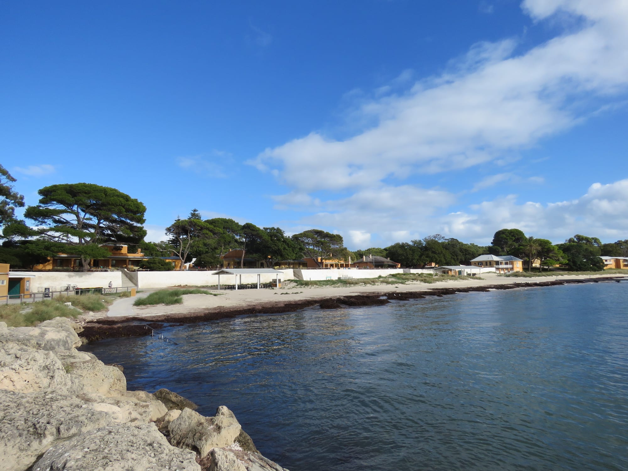
A sheltered blue bay behind a low seawall, with the yellow and white buildings of a small settlement among tall trees

Western Australia, Australia

Rottnest Island

Thomson Bay Settlement on the sheltered eastern side of Rottnest Island. (Calistemon / Wikimedia Commons · CC BY-SA 4.0)

A car-free island of low limestone and salt lakes about 18 kilometres off Fremantle, in Western Australia, known to Noongar people as Wadjemup. Named by a Dutch captain who mistook its quokkas for rats, later a prison for Aboriginal men and boys, it is now a reserve of sheltered bays and bicycle tracks visited by hundreds of thousands of people a year.

Neighbourhoods

  • Thomson Bay Settlement
    • First-time visitors
    • Close to the ferry
    • Best for food

    The island's only real village, on the sheltered eastern shore where the ferries dock. A bakery, a general store, cafés, the pub, the museum and the visitor centre stand around a lawn and a long jetty, and most of the island's accommodation is here, from old limestone cottages to a campsite and simple units.

    Open in Maps
  • Geordie Bay and Longreach Bay
    • Beaches
    • Families
    • Quiet and residential

    Two calm bays on the north coast about two kilometres west of the settlement, lined with rows of holiday villas and rimmed by moorings that fill with boats in summer. A small shop and café serve them, the swimming is sheltered, and the ride back to the ferry is short.

    Open in Maps
  • The Basin and Pinky Beach
    • Beaches
    • Snorkelling
    • Short walk from the ferry

    The nearest swimming to the settlement, ten to fifteen minutes on foot to the north. The Basin is a clear pool held inside a reef, and Pinky Beach curves below the white tower of Bathurst Lighthouse. Both are busy with day visitors whenever the weather is warm.

    Open in Maps
  • The West End
    • Wildlife and views
    • Cycling
    • Walks

    The exposed western tip, around ten kilometres from the settlement and the reward for the island's longest ride. Low limestone cliffs, boardwalks and lookouts face the open Indian Ocean and seals lie on the rocks below. There is no shade and nowhere to buy water.

    Open in Maps
  • The salt lakes and Wadjemup Hill
    • Cycling
    • Wildlife
    • Walks

    The island's interior, a chain of shallow salt lakes fringed with white crust and low scrub, with the lighthouse on Wadjemup Hill above them. Roads and trails cross it between the two coasts, and quokkas, ospreys and waders are easiest to see here early and late in the day.

    Open in Maps

Things to do

Landmarks and history

  • Wadjemup Lighthouselandmark

    A limestone lighthouse on Wadjemup Hill, the island's highest point, built with prisoner labour from about 1849 and replaced by a larger tower in 1896, with views across the salt lakes to both coasts.

    Open in Maps
  • Bathurst Lighthouselandmark

    A slender white lighthouse activated in 1900 on Bathurst Point at the island's north-eastern corner, above Pinky Beach and a short walk from the settlement.

    Open in Maps
  • Oliver Hill Batterylandmark

    A Second World War coastal battery in the middle of the island, part of the Fremantle Fortress defences, with two 9.2-inch guns that could reach 28 kilometres out to sea and tunnels beneath them.

    Open in Maps
  • Oliver Hill Railwayattraction

    A heritage railway on the line begun in 1935 to serve the gun battery, now carrying visitors from the settlement up to Oliver Hill.

    Open in Maps

Short trips from the island

  • Fremantle Prisonmuseum

    A World Heritage-listed convict prison above the ferry terminals in Fremantle, built by transported convicts in the 1850s and in use until 1991, with tours of its cell blocks and tunnels.

    Open in Maps
  • Western Australian Maritime Museummuseum

    A museum on Victoria Quay in Fremantle whose collection includes Australia II, the yacht that won the America's Cup in 1983, with a submarine moored alongside.

    Open in Maps
  • Fremantle Marketsmarket

    A market hall of 1897 near the ferry jetties, with produce, food stalls and craft under one iron roof.

    Open in Maps
  • Cottesloe Beachbeach

    The Perth beach that faces the island across the channel, backed by Norfolk Island pines and the starting line of the annual Rottnest Channel Swim.

    Open in Maps

Seasonal events

  • Rottnest Channel SwimFebruary

    An open-water race of about 20 kilometres from Cottesloe Beach on the mainland to Thomson Bay, swum solo, in duos and in teams by thousands of entrants.

  • Whale migrationwinter and spring

    Humpback whales pass the island on migration, with southern right and blue whales in the deep water of the Perth Canyon offshore, watched from the headlands at the western end and from boats.

  • School leavers' weeklate November

    Western Australian school leavers have long marked the end of their exams on the island, filling the settlement and its cottages for a week.

Eat and drink

Long-standing places and food districts in Rottnest Island. Hours, ratings and directions come from your maps app, always current.

On the island

  • Thomson Bay Settlementneighborhood

    Almost all of the island's eating and drinking is within a few minutes of the main jetty — a bakery known for its pies and sausage rolls, a general store, a fish and chip counter, cafés and the pub on the foreshore.

    Open in Maps
  • Hotel Rottnestrestaurant

    The pub on the Thomson Bay foreshore, in the island's old Government House, one of the limestone buildings raised by Aboriginal prison labour, with a beer garden looking out at the water.

    Open in Maps
  • Geordie Bayneighborhood

    The general store and café serving the holiday villas on the north coast, useful for supplies and coffee for anyone staying away from the settlement.

    Open in Maps

Before or after the ferry

  • Fremantle Fishing Boat Harbourneighborhood

    The working harbour beside the Rottnest ferry terminals, where fish and chips, chilli mussels and Italian-Australian cooking have been served beside the boats for decades.

    Open in Maps
  • Fremantle Marketsmarket

    A Victorian market hall of produce, food stalls and craft near the Fremantle ferry jetties, open at the end of the week.

    Open in Maps

Experience Rottnest Island

History

Rottnest lies about 18 kilometres off the mouth of the Swan River and was joined to the mainland until rising seas cut it off around 7,000 years ago. Noongar people know it as Wadjemup, the place across the water, and associate it with the spirits of the dead; stone tools show that people lived there before the sea rose. In 1696 the Dutch captain Willem de Vlamingh landed, mistook its quokkas for large rats and called it Rottenest, the rat's nest.

After the Swan River Colony was founded in 1829, settlers tried farming and salt harvesting here, and then the colonial government turned the island to another use. From 1838 until 1931 it held a prison for Aboriginal men and boys brought from across Western Australia, deliberately far from their own country. More than 3,600 people were imprisoned there over its 93 years; they were held in a walled cell block known as the Quod, built in 1863 and 1864, and worked on the island's roads, walls and buildings, and at least 373 died and lie in unmarked graves north of the Quod. A boys' reformatory and, in the First World War, an internment camp followed.

In the Second World War gun batteries at Oliver Hill and Bickley were built to defend the approaches to Fremantle. From the middle of the twentieth century the island was managed as a holiday reserve, and it now takes hundreds of thousands of visitors a year. The Quod was used as tourist accommodation until 2018, when it was closed after decades of protest by Aboriginal people, and work with Noongar elders now protects the burial ground and tells the prison's story plainly.

Culture & Customs

For Perth, Rotto is an institution rather than a destination. Families return to the same holiday cottages year after year, often through a ballot for the busiest weeks, and children learn the island by bicycle. The absence of cars sets the tone: everything moves at walking or pedalling pace, and the settlement's lawns, jetties and pub foreshore are where the day ends.

Two traditions mark the calendar. In February thousands of swimmers cross the channel from Cottesloe Beach in the Rottnest Channel Swim, one of the largest open-water races anywhere, and in late November school leavers have long spent a week on the island after their exams. Fishing, sailing and diving clubs have used the bays for generations, and the moorings fill with mainland boats each summer.

The quokka has made the island internationally famous, and close-up photographs of the animals circulate widely; handling or feeding them is prohibited, and rangers press the point. Alongside the holiday island runs a second, quieter meaning. For Noongar people Wadjemup is a place of death and mourning, and the burial ground near Thomson Bay is treated accordingly, with visitors asked to stay outside its fenced area. Noongar guides now tell the island's history to those who want to hear it, and the Noongar name is used alongside the Dutch one.

Daily Life

Only a few hundred people live on Rottnest, most of them working for the authority that manages the reserve or for the hotels, shops, cafés and hire businesses in Thomson Bay. Rangers, maintenance crews, police and nursing staff make up much of the rest, and many workers commute by ferry or live in staff housing for a season at a time.

The visitors are the population that matters economically. Around 780,000 people come each year, the great majority for a single day, and the island's rhythm follows the ferries — quiet mornings, a crowded middle of the day around the main jetty, then a long emptying in the afternoon. Summer and the Christmas and Easter holidays fill every bed, while in winter the settlement can feel almost closed.

Everything else arrives by sea. Food, fuel and supplies come by barge and waste leaves the same way; water is drawn from the island's own bores and a reverse-osmosis desalination plant, and a wind turbine supplies about a third of its electricity alongside diesel generators. Accommodation is limited by design, because the whole island is a reserve, and pressure to add more of it is a recurring argument. So are the wear that heavy visitor numbers put on the bays and tracks, the welfare of the quokkas, coastal erosion, and the work of running a holiday island that is also a burial ground.

Food

Rottnest is not a restaurant island, and many visitors bring a cool box from the mainland. What is there clusters in Thomson Bay — a general store, a bakery whose pies and sausage rolls are a fixture of the ferry queue, a fish and chip counter, a few cafés and a pub on the foreshore — with a smaller store and café serving the villas at Geordie Bay. Public barbecues stand near the main bays, and self-catering in a cottage or a tent is the usual arrangement.

The flavours are Western Australian. Western rock lobster, which locals call crayfish, is caught along this coast, and fish and chips is the standard island meal, made with whiting, dhufish or Australian salmon. Squid and herring are taken from the jetties and the rocks, and anglers work the beaches during the autumn salmon run. Coffee is taken as seriously as it is across Perth, and the drinks lists lean on Margaret River and Swan Valley wines and beer brewed in Fremantle.

Prices are higher than on the mainland because everything crosses the water, and the shops are small. Many people eat their best meal of the trip at the fishing boat harbour in Fremantle, where fish and chips, chilli mussels and Italian-Australian cooking have been served beside the boats for decades, a short walk from the Rottnest ferries.

Planning tools

Budget

The ferry is the biggest fixed cost of a Rottnest visit, and the fare usually includes the island's admission charge. Accommodation is limited and expensive in the summer and at Easter, when it is heavily booked. Food, drink and supplies cost more than on the mainland because everything crosses by barge, so many visitors bring their own. Bicycle hire or a bus pass is the main cost once ashore.

Daily Budget Midrange
USD 200–360 (a villa or hotel room on the island, pub and café meals, bicycle or bus hire, a snorkelling or boat trip)
Daily Budget Shoestring
USD 60–120 (day return ferry, a campsite or dormitory bed, food carried from the mainland, a hired bicycle)

Book accommodation and summer ferries well ahead; the beaches, the snorkelling and the walking trails cost nothing.

Best Time to Visit

March to May and September to November are the best months, with warm days, swimmable water, wildflowers in spring and far fewer people than the school holidays. December to February is hot, bright and busy, and the sea is at its warmest. Winter is mild and green but wet and windy, and rough weather can cancel sailings.

Suggested Number of Days

Most visits are a single day on the ferry, which is enough for a swim and a stretch of the coast road. A night or two adds the quieter western half of the island and the early mornings before the day boats arrive. Snorkellers, cyclists and anglers stay longest.

First Visit
1 day
With Surroundings
2–3 days

Transportation

There are no private cars on the island. Almost everyone hires a bicycle near the main jetty or brings one across on the ferry; the roads are sealed and narrow, with some steep pinches, and a full loop of the island is the longest ride most visitors attempt. A bus links the settlement with the northern bays, a coach service calls at the main beaches and lookouts, and a heritage train climbs to Oliver Hill.

Helmets are compulsory for cyclists in Western Australia, and bicycles, helmets and snorkelling gear can be booked with a ferry ticket; headwinds make the ride to the western end harder than the distance suggests.

Airport & Station Connections

Ferries are the only scheduled way across. The shortest crossing leaves from Fremantle, about 18 kilometres away, and takes roughly half an hour; services also run from Hillarys Boat Harbour in Perth's northern suburbs and, more slowly, from central Perth down the Swan River. Light aircraft use the island's small airstrip, and private boats take up the moorings in the bays. Perth Airport is about an hour from the Fremantle terminals by road.

Walkability

The settlement itself is small and entirely walkable, and The Basin and Pinky Beach are ten to fifteen minutes away on foot. Beyond that the island is bigger than it looks and the walking is done on trails rather than pavements. Walking trails cross the island in linked sections, but shade and drinking water are scarce and the western end is a long way out.

Safety

Rottnest is a safe place with environmental rather than criminal risks. Sunburn, heat and dehydration are the commonest problems, because there is almost no shade away from the settlement. Beaches are mostly unpatrolled, with rips and boat traffic on the northern side, and the limestone cliffs and rock platforms at the western end are slippery and exposed to large swells. Bicycles, buses and coaches share narrow roads.

Carry more water than seems necessary, wear a helmet, keep behind the fences and boardwalks above the western cliffs, and do not touch or feed the quokkas. Check current official travel advice before travelling.

Climate

A Mediterranean climate of hot dry summers and mild wet winters, softened by the sea on every side. The island is windier than Perth, with a strong afternoon sea breeze off the water in summer, and the south coast is choppier than the north. In the southern hemisphere summer falls in December to February and winter in June to August.

Summer
warm and dry — December to February days are usually around 24–29°C, cooled by the afternoon sea breeze, with the sea at its warmest in February and March
Winter
mild and wet — June to August days are around 17–19°C, with cold fronts bringing rain and strong winds that can disrupt ferry sailings

Local Customs

Manners are informal and Australian. Tipping is not expected, though change is sometimes rounded up for good service; swimwear belongs on the beach rather than in the pub; and cyclists are expected to give way to walkers and buses. Quokkas are protected, and touching, feeding or picking them up is prohibited. Wadjemup is a place of mourning for Noongar people as well as a holiday island, and the burial ground near Thomson Bay is treated as a cemetery.

Quokkas may be photographed but never handled or fed, the fenced burial ground is closed to visitors, and rubbish and fishing line have to leave the island by barge like everything else.

Common Payment Methods

The currency is the Australian dollar. Cards and contactless payment are taken almost everywhere on the island, and some outlets no longer accept cash at all. Cash machines are confined to the main settlement, so it is simpler to arrive with what is needed, and mobile coverage, on which card terminals depend, is patchy at the western end.