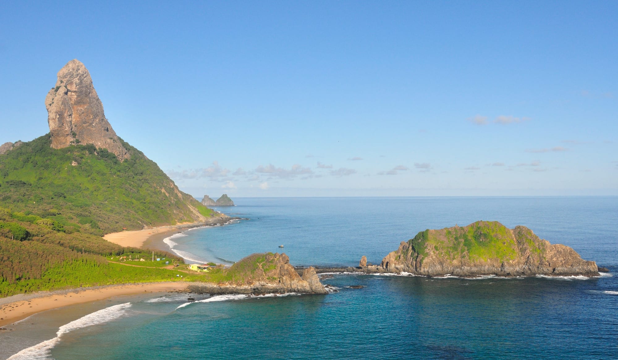
The tall rock spire of Morro do Pico above a green slope and curving beaches, with blue sea and rocky islets

Recife, Natal & the Northeast Coast, Brazil

Fernando de Noronha

Morro do Pico and the beaches of Cachorro and Conceição, seen from the lookout at the Remédios fort. (Brunno Monteiro Lira / Wikimedia Commons · CC BY-SA 3.0)

A volcanic archipelago of 21 islands and islets in the Atlantic, about 350 km off Brazil's north-east coast and governed by Pernambuco. For centuries a fortified prison island, it became a marine national park in 1988 and a UNESCO World Heritage Site in 2001; today a few thousand residents live from carefully limited tourism built around beaches, diving and dolphins.

Neighbourhoods

  • Vila dos Remédios
    • First-time visitors
    • Historic district
    • Best for food

    The island's largest settlement and administrative centre, founded by the Portuguese in 1737 around a fortress. The Baroque church, the ruins of the Remédios fort and the old prison buildings stand among guesthouses, shops and restaurants, with steep paths down to the beaches of the inner sea.

    Open in Maps
  • The port and Santo Antônio Bay
    • Boat trips
    • Diving

    The harbour at the northern end of the island's single road, where boat tours and dive trips leave and the island bus begins its run. It is a working, informal corner of the island, with açaí sold to divers coming back from the morning's dives.

    Open in Maps
  • Boldró and the inner-sea beaches
    • Beaches
    • Sunset

    The stretch of the main road above the beaches that face the mainland — Americanos, Boldró, Conceição, Meio and Cachorro, which follow one another along the shore. The national park's ticket office is on the Alameda do Boldró, and guesthouses are scattered through the area.

    Open in Maps

Things to do

Beaches and bays

  • Baía do Sanchobeach

    A bay of clear water on the side facing the mainland, regularly listed among Brazil's best beaches and voted the best beach in the world by TripAdvisor users.

    Open in Maps
  • Baía dos Porcosbeach

    The next bay along from Sancho on the side facing the mainland, considered by many the most beautiful beach on the island.

    Open in Maps
  • Praia do Leãobeach

    An unshaded beach on the Atlantic-facing side of the island, with clear water for swimming and snorkelling; with Sancho, it is closed to visitors at night from January to June.

    Open in Maps
  • Baía do Suestebeach

    A bay at the southern end of the island's road where sea turtles are seen.

    Open in Maps

Nature and the sea

  • Fernando de Noronha Marine National Parkpark

    Created in 1988 and run by ICMBio, it covers most of the archipelago and its waters; a separate park ticket is needed for most beaches and trails, and some trails need a booking and a licensed guide.

    Open in Maps
  • Baía dos Golfinhosviewpoint

    The bay where the archipelago's resident spinner dolphins gather, one of the reasons UNESCO gave for listing the islands.

    Open in Maps
  • Atalaia tide poolbeach

    A natural tide pool home to lobsters, octopuses and many fish, visited only by reservation and for a limited time, standing only on its small sandy patch.

    Open in Maps

History in Vila dos Remédios

  • Forte de Nossa Senhora dos Remédioslandmark

    The most prominent of the forts built after the Portuguese expelled the French in 1737–38, now in ruins, with a lookout over the inner-sea beaches and Morro do Pico.

    Open in Maps
  • Igreja de Nossa Senhora dos Remédioslandmark

    The church built at the same time as the fort, in a simplified Baroque-rococo style, protected as national heritage and restored in 1988.

    Open in Maps

Eat and drink

Long-standing places and food districts in Fernando de Noronha. Hours, ratings and directions come from your maps app, always current.

Fernando de Noronha classics

  • Açaí at the portmarket

    Bowls of açaí, the dark purple Amazonian fruit pulp, eaten with granola and banana by divers coming back to the harbour.

    Open in Maps
  • Restaurants in Vila dos Remédiosneighborhood

    The island's main cluster of places to eat, from self-service buffets priced by weight to seafood restaurants serving moquecas and shellfish.

    Open in Maps
  • Boldró restaurantsneighborhood

    Restaurants along the main road near the inner-sea beaches, serving grilled picanha, moquecas and shellfish.

    Open in Maps

Experience Fernando de Noronha

History

The archipelago was sighted by the earliest European navigators, and an island much like it appears on the Cantino map of 1502. The written record dates its discovery to 10 August 1503, when a Portuguese expedition under Gonçalo Coelho lost its flagship on a reef nearby and Amerigo Vespucci spent a week ashore. King Manuel I granted the island as a hereditary captaincy to Fernão de Loronha, the Lisbon merchant who financed the voyage, and for a few years it served as the collection point for brazilwood gathered along the mainland coast. His name, misspelt, displaced the official name of São João.

Other powers came and went. The Dutch held the island in the 17th century, and the French East India Company tried to colonise it in 1736, until a Portuguese expedition from Recife expelled them. Portugal then fortified the island with a chain of forts, founded the town of Nossa Senhora dos Remédios in 1737 and turned the island into a prison. Trees were cut down so that prisoners could neither hide nor build rafts. Charles Darwin landed briefly from HMS Beagle in 1832.

In the 20th century the prison held political prisoners, and in 1942 the islands became a federal territory; the United States built an airport for the wartime air route between Natal and Dakar. After the 1964 coup the deposed governor of Pernambuco, Miguel Arraes, was held here. In 1988 most of the archipelago became a marine national park and the islands were joined to Pernambuco, and in 2001 UNESCO listed them, with Rocas Atoll, as a World Heritage Site.

Culture & Customs

The islanders are, in the words of Brazil's statistics institute, a population left by the island's many periods: descendants of common and political prisoners, guards and soldiers, of people posted here for work, and of newcomers who arrived for tourism and stayed. That mixture gives Noronha a small-town, mainland-Pernambuco character with a strong sense of being apart, reinforced by the island's own time zone, an hour ahead of the mainland coast.

The fortified past is the island's heritage. In 2017 Brazil's heritage institute, IPHAN, protected the historic ensemble as national cultural heritage — the forts, the town of Vila dos Remédios, the village of Quixaba, the fishermen's chapel of São Pedro and the old Air France building from the days of transatlantic mail flights. The Baroque church of Nossa Senhora dos Remédios, built with the fort, is the centre of the village.

The natural world shapes daily customs more than any tradition. Visitors and residents live under the rules of the national park and the environmental protection area: limits on numbers, bookings for the most fragile pools and trails, guides on some paths, and night closures of some beaches for part of the year. Diving, snorkelling and surfing are the island's shared pastimes, and the remote location even draws amateur radio operators, who count the archipelago as a separate entity to contact.

Daily Life

Only the main island is inhabited, with 3,167 people at the 2022 census. The archipelago is a state district administered directly by the government of Pernambuco rather than a normal municipality, and its jurisdiction also takes in the distant Saint Peter and Saint Paul rocks.

Tourism is the economy — dolphin watching, diving, charter fishing, guesthouses, buggies and boats — and it is deliberately restricted by the limits of a fragile ecosystem with scarce fresh water. The island has its own environmental problems: introduced species threaten its wildlife: tegu lizards, released in the 1950s to control rats, now feed mostly on bird eggs, feral cats prey on native birds, and rock cavies were brought in by the military in the 1960s.

Energy has long come from a fuel-burning power plant. In November 2025 the archipelago's first floating solar plant was opened on the Xaréu reservoir, and a larger solar and battery project, Noronha Verde, aims to make Fernando de Noronha the first inhabited oceanic island in Latin America to run entirely on sustainable energy. Daily life follows the sea and the light: early starts for dives and boat trips, afternoons on the beaches, and evenings gathered at the lookouts for the sunset.

Food

Eating on Noronha is shaped by distance from the mainland, which makes it expensive, and by the sea around it. Seafood dominates restaurant menus: grilled fish, shellfish, and moquecas, the Brazilian fish stews cooked in a clay pot. Grilled picanha, the prized Brazilian cut of beef, is a steakhouse staple here as on the mainland, and Italian and sushi menus have followed the visitors.

The everyday option is the self-service buffet, where food is paid for by weight — the cheapest way to eat well, and a common lunch for residents and visitors alike. Many of these buffets serve both lunch and dinner, with rice, beans, salads, grilled meat and fish.

After a morning of diving, the island habit is a bowl of açaí at the port: the thick, cold, dark purple pulp of an Amazonian palm fruit, topped with granola and sliced banana. Tropical fruit juices, coconut water and cold beer are the drinks of the beaches, and the caipirinha, made with cachaça, lime and sugar, is the drink of the sunset.

Planning tools

Budget

Fernando de Noronha is one of the most expensive places to visit in Brazil. Its isolation, the cap on visitor numbers and the strict protection of the islands keep lodging, food and tours costly, and every visitor pays a daily environmental preservation fee that grows with the length of stay, plus a separate national park ticket for most beaches and trails.

Daily Budget Midrange
USD 300–600 (comfortable guesthouse, seafood dinners, boat or dive trips, buggy hire, plus fees)
Daily Budget Shoestring
USD 120–200 (simple guesthouse room, buffet-by-weight meals, the island bus, plus the daily preservation fee)

Pay the preservation fee online before arrival or at the port of entry, and buy the park ticket early, since it is needed for most of the best beaches.

Best Time to Visit

The dry months from August to January bring the clearest skies; the rainy season runs from February to July, though temperatures change very little through the year. The water is warm all year and visibility for diving can reach 50 metres. Visitor numbers are limited, so rooms and flights for Brazilian holidays fill early.

Suggested Number of Days

Most visitors stay four or five days, which allows for the main beaches, a boat trip and a dive or two. Longer stays suit divers and anyone who wants to book the guided trails, though the preservation fee rises with each extra day.

First Visit
4–5 days
With Surroundings
6–8 days

Transportation

A single road, the BR-363, runs the length of the main island from the port in the north to Sueste Bay in the south. One bus line covers it end to end in a little over twenty minutes, running from early morning to late evening. Many visitors hire a buggy or car, take taxis, or join buggy and boat tours; locals often give lifts to hitchhikers.

Visiting any island other than the main one needs special permission from the environmental authority; only Morro São José can be visited, with a booking.

Airport & Station Connections

Gov. Carlos Wilson Airport, about 4 km from Vila dos Remédios, is the only way most visitors arrive, with daily flights from Recife, about 545 km away (around 1 hour 40 minutes), and Natal, about 360 km away (around 1 hour 10 minutes). In high season a few cruises call from the mainland coast. All visitors must pay the environmental preservation fee.

Walkability

Vila dos Remédios is compact and walkable, though hilly. The main island is about 10 km long, so the beaches are spread out and most people use the bus or a buggy between them. The trails inside the national park need a ticket, and some a guide.

Safety

Brazil has high rates of crime, including violent crime, and it is the main practical concern for visitors — though very unevenly distributed. On Fernando de Noronha the main risks for visitors are the sea and the sun: strong tropical sun and shark incidents, which are rare but do occur.

Follow the park's rules on where to swim and snorkel, do not enter the water in the dark or when visibility is poor, and carry water and shade to the beaches. Check current official travel advice before travelling.

Climate

A tropical wet and dry climate with very little change in temperature from day to night or month to month. Rain falls mainly from February to July, and the rest of the year is mostly dry; the island keeps the same time, UTC−2, all year.

Summer
warm all year, around an annual mean of 27°C; December and January are dry, and the rains begin in February
Winter
still close to the 27°C annual mean; June and July are the end of the rainy season, which peaks in April, and August is dry again

Local Customs

The island is protected first and visited second, and its rules are enforced: standing only on the sandy patch in the Atalaia pool, bookings and guides for certain trails, and no collecting shells, coral, rocks, plants or animals. Dress is casual beachwear, with a little more cover in the village and the church.

Respect the closure of Leão and Sancho beaches at night from January to June, keep a distance from dolphins and turtles, and learn a little Portuguese — English is not widely spoken.

Common Payment Methods

The currency is the Brazilian real. Many guesthouses and restaurants take cards, but the island has only two bank branches, Santander and Bradesco, and one or two other cash machines, so bring enough cash from the mainland for small purchases.