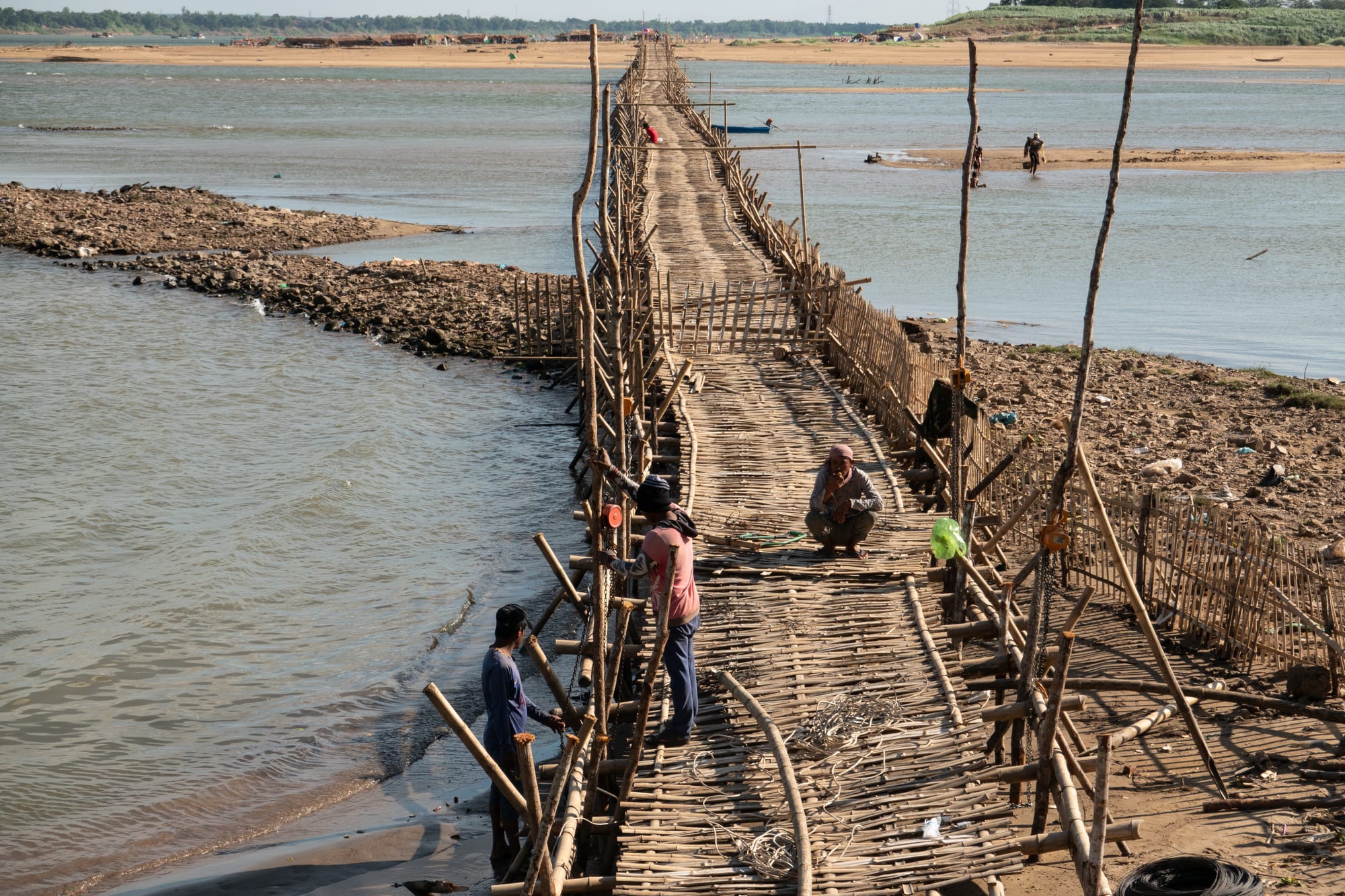
A narrow bamboo bridge on stilts running across sandbanks and a channel of a wide river, with a few people working on its near end

Phnom Penh, Kampong Cham & the Mekong, Cambodia

Kampong Cham

The bamboo bridge to the island of Koh Paen, built by hand across the Mekong at Kampong Cham for the dry season. (PsamatheM / Wikimedia Commons · CC BY-SA 4.0)

A provincial capital on the west bank of the Mekong upstream of Phnom Penh, once a French rubber and trading town and still one of the quietest riverside towns in Cambodia. Its landmarks are the Angkorian temple of Wat Nokor, the twin hills of Phnom Pros and Phnom Srei, and the island of Koh Paen, crossed to in the dry season by a bridge built from bamboo by hand.

Neighbourhoods

  • The riverfront and old quarter
    • First-time visitors
    • Riverside walks
    • Best for food

    A short strip of French-era shophouses and government buildings facing the Mekong, with the town's guesthouses, cafés and riverside restaurants. The promenade fills in the late afternoon when the heat drops and food carts set up.

    Open in Maps
  • Around the central market
    • Markets
    • Local life

    The commercial centre a couple of blocks inland, built around the covered market hall and the streets of traders, phone shops, tailors and noodle kitchens that surround it. Busiest before eight in the morning.

    Open in Maps
  • Koh Paen
    • Cycling
    • Villages
    • Quiet

    The long sandy island in the Mekong opposite the town, reached by boat and, in the dry months, by the bamboo bridge when it is standing. Sandbank beaches, vegetable plots, tobacco fields and stilt-house villages, with almost no traffic.

    Open in Maps
  • The Kizuna Bridge road and the east bank
    • Transport
    • Day trips

    The approach to the long bridge over the Mekong towards Tboung Khmum, lined with petrol stations, workshops and guesthouses. The far bank leads into rubber country and riverside Khmer and Cham villages.

    Open in Maps
  • The hill road south-west
    • Temples
    • Short trips

    The road out towards Phnom Pros and Phnom Srei, passing Wat Nokor and the edge of town where houses give way to rice fields, palm trees and pagoda compounds.

    Open in Maps

Things to do

Temples and hills

  • Wat Nokorlandmark

    An Angkorian temple of laterite and dark sandstone from the last years of Jayavarman VII's reign, on the edge of town, unusual because a modern pagoda has been built inside and around the older shrines, which are still in use.

    Open in Maps
  • Phnom Pros and Phnom Sreilandmark

    The hills of the Man and the Woman a few kilometres from town, each topped with pagodas and linked by a legend about a contest between the sexes; monkeys live in the trees below.

    Open in Maps
  • Wat Hancheylandmark

    A hilltop monastery upstream with a small pre-Angkorian brick sanctuary of the Chenla period beside modern halls, and a long view down the Mekong.

    Open in Maps

The river and the island

  • Koh Paen bamboo bridgelandmark

    A bridge of lashed bamboo, built by hand for the dry season to carry motorbikes, bicycles and walkers over to the island and lost to the water when the river rises, though whether it goes up varies from year to year.

    Open in Maps
  • Koh Paenattraction

    The Mekong island opposite the town, with sandbank beaches used for swimming in the dry months, vegetable gardens and quiet village lanes for cycling.

    Open in Maps
  • Kizuna Bridgelandmark

    The long road bridge over the Mekong, opened in 2001 with Japanese funding and for years the only permanent crossing of the river inside Cambodia.

    Open in Maps
  • The Mekong promenadeviewpoint

    The paved riverside walk in front of the old quarter, where benches, drinks stalls and evening crowds face the water and the island beyond.

    Open in Maps

Markets and town life

  • Kampong Cham central marketmarket

    The town's covered market, selling river fish, fruit, vegetables, dried goods and cloth, with a food section serving noodles and rice dishes from early morning.

    Open in Maps
  • The French-era shophouse streetsneighborhood

    Two or three blocks of arcaded colonial buildings behind the riverfront, some restored as cafés and guesthouses and others left weathered.

    Open in Maps

Short trips from the town

  • Skuonneighborhood

    A crossroads town south-west of Kampong Cham, known across the country for the fried tarantulas sold at its roadside stalls.

    Open in Maps
  • Chup rubber plantationsattraction

    The rubber estates east of the river, first planted in the French period, where tapped trees stand in long avenues and processing sheds line the roads.

    Open in Maps
  • Cham villages on the Mekongneighborhood

    Fishing and trading villages of the Cham Muslim community along both banks, with mosques, stilt houses and boat-building yards.

    Open in Maps

Seasonal events

  • Water FestivalOctober or November, at the full moon

    Bon Om Touk, marked here with boat races on the Mekong in front of the town and crowds along the promenade.

  • Khmer New Yearmid-April

    Three days of pagoda offerings, games and water throwing, when the hills at Phnom Pros and Phnom Srei fill with families.

  • Pchum BenSeptember or October

    The fortnight when families bring rice and offerings to pagodas for their ancestors, observed strongly in this rural province.

Eat and drink

Long-standing places and food districts in Kampong Cham. Hours, ratings and directions come from your maps app, always current.

Riverside and market food

  • Riverfront restaurants and food cartsneighborhood

    Simple places and evening carts along the Mekong promenade serving grilled river fish, beef lok lak, fried rice and noodle soups with cold beer.

    Open in Maps
  • Kampong Cham central marketmarket

    The main market, where the cooked-food aisles sell kuy teav, bai sach chrouk, curries and palm-sugar sweets to shoppers from dawn.

    Open in Maps
  • Cafés in the old quartercafe

    A handful of small cafés in restored shophouses near the river, serving strong iced coffee with condensed milk and Khmer breakfasts.

    Open in Maps

Experience Kampong Cham

History

The name means "port of the Cham", a reminder that Cham traders and refugees from the kingdom of Champa, in what is now central Vietnam, settled along this stretch of the Mekong from the 15th century onwards, and their descendants still live in villages on both banks. Long before that, the area lay within the Khmer world: Wat Nokor on the edge of town was built in the last years of Jayavarman VII's reign, and the brick sanctuary at Wat Hanchey upstream dates from the Chenla period, centuries earlier still.

The modern town is largely a French creation. Under the protectorate, Kampong Cham became a provincial seat and the centre of Cambodia's rubber industry, with large plantations laid out to the east of the river from the 1920s, worked by labourers recruited from Vietnam and the Cambodian countryside. Shophouses, offices and a market went up behind the riverfront, and the Mekong carried rubber, tobacco and rice down to Phnom Penh and Saigon.

The province suffered heavily in the 1970s: American bombing of the countryside, early Khmer Rouge control, and the forced labour and killings of the regime's years in power, followed by fighting as Vietnamese forces advanced in 1979. Rubber estates fell into neglect and were only gradually replanted. Since the 1990s the town has been quiet and slow-growing. The Kizuna Bridge, opened in 2001, gave it the first permanent road crossing of the Mekong in Cambodia, and Tboung Khmum province was split off from Kampong Cham in 2013.

Culture & Customs

Kampong Cham is one of the most mixed provinces in the country. Khmer Buddhist villages, with their pagodas and annual merit-making, stand alongside Cham Muslim communities whose mosques, prayer calls and headscarves are a normal part of the riverside landscape; fishing, boat building and cattle trading are traditional Cham occupations here. Chinese-Cambodian families run much of the town's commerce, and Vietnamese families have long lived along the river.

The Buddhist calendar shapes the year for the majority: Khmer New Year in April, when the hills at Phnom Pros and Phnom Srei fill with picnics and games; Pchum Ben in the autumn, when families bring rice to the pagodas before dawn for their ancestors; and the Water Festival, when boats race on the Mekong in front of the town. The Cham communities keep the Islamic calendar, with Ramadan and its feasts observed in the villages.

The province has a reputation in Cambodia for education and for producing public figures, and its schools are well regarded. Manners are those of the countryside: quiet, formal and hospitable. Visitors are greeted with the sampeah, invited to sit and given a drink, and expected to dress modestly away from the river, to remove their shoes at doorways and to be careful with photographs at pagodas and mosques.

Daily Life

Kampong Cham is a small provincial capital of about 62,000 people, well down the list of Cambodian cities by size, and it feels smaller still: a few streets of commerce around the market, a riverfront that comes alive at dusk, and countryside beginning within minutes of the centre. Mornings start before six, with the market at its busiest and monks on their alms rounds; the middle of the day is spent out of the sun; and the evening belongs to the promenade.

The province lives from farming. Rubber remains important on the plantations east of the river, alongside rice, cassava, maize, tobacco and soya, and the Mekong supplies fish, sand and vegetable gardens on the islands and banks that are planted as the water falls. The town provides the schools, hospital, offices and market that the countryside depends on, and the bridge and highway make it a stop on the route between the capital and the north-east.

Many young people leave for factory work in Phnom Penh or for jobs in Thailand, and remittances support households across the province. Falling fish catches, debt from microloans and the erosion of riverbanks are common local worries. Tourism is small-scale: a handful of guesthouses, cyclists heading for the island, and travellers pausing for a night on the way north.

Food

The river sets the table. Fish from the Mekong is grilled whole over charcoal, fried with garlic, dried in the sun or fermented into prahok in the dry season, and eaten with rice at almost every meal. Samlor korko, the thick soup of fish and mixed vegetables, is a village staple, and fish amok, steamed in banana leaf with coconut and the lemongrass paste called kroeung, appears on restaurant menus along the riverfront.

Breakfast is kuy teav, the pork-broth rice-noodle soup, or bai sach chrouk, grilled marinated pork with broken rice and pickles, both sold at the market and from carts near the river. Nom banh chok, rice noodles with a green fish gravy, is carried round the streets in the morning. Beef lok lak with a lime and black-pepper dip is the standard restaurant dish, and num pang, the baguette filled with pâté and pickles, is eaten at any hour.

The province is known for two other things. Rubber-country roadsides sell tropical fruit in season, and Skuon, on the road towards Phnom Penh, is famous across Cambodia for deep-fried tarantulas, eaten as a snack with lime and pepper. The Cham villages cook halal beef and chicken curries with their own spicing, and sugar-palm juice, palm-sugar cakes and iced coffee with condensed milk are drunk everywhere.

Planning tools

Budget

Prices here are well below those in Phnom Penh. Guesthouses and small hotels near the river are inexpensive, market meals cost very little, and a bicycle or motorbike is enough to reach the temples, the hills and the island. The main extra cost is a car and driver for trips further into the province.

Daily Budget Midrange
USD 45–90 (riverside hotel, restaurant meals, a car and driver for day trips)
Daily Budget Shoestring
USD 15–30 (guesthouse, market food, shared transport and a rented bicycle)

Carry small dollar notes and riel; cash machines are in the centre but smaller villages and the island have none.

Best Time to Visit

November to February is dry, warm and the most comfortable season, and it is also when the bamboo bridge to Koh Paen is usually in place. March and April are very hot. The rains from May to October raise the Mekong, turn the province green and put the island crossing back on the ferry.

Suggested Number of Days

A day or two is enough for the town, the island and the nearby temples and hills. An extra day allows a slower look at the rubber country and the riverside villages across the Mekong, and many travellers stop here for one night between Phnom Penh and the north-east.

First Visit
1–2 days
With Surroundings
2–3 days

Transportation

The town is small and flat, and bicycles, rented at guesthouses, are the usual way to reach Koh Paen, Wat Nokor and the hills. Tuk-tuks and motorbike taxis wait near the market and the riverfront for longer journeys, and buses and minivans leave from the centre for Phnom Penh, Kratie and the Vietnamese border.

Agree tuk-tuk fares in advance, and check whether the bamboo bridge is standing before setting out for the island, as the crossing moves to a ferry when the river is high.

Airport & Station Connections

Buses and minivans take about three hours from Phnom Penh, some 124 kilometres to the south-west down the Mekong, on a good road; services also run north to Kratie and east towards the Vietnamese border. There is no airport, so the nearest arrival point by air is the capital, and the Kizuna Bridge carries the road across the Mekong to Tboung Khmum province.

Walkability

The centre is compact: the riverfront, the market, the guesthouses and the old shophouse streets are all within ten or fifteen minutes on foot, and traffic is light compared with the capital. Beyond that, the heat and the distances to Wat Nokor and the hills make a bicycle, motorbike or tuk-tuk the sensible choice.

Safety

The town is calm and crime against visitors is unusual, limited mostly to opportunist theft. Road accidents are the main danger, particularly on motorbikes and on the highway, and the Mekong has strong currents and sudden drop-offs even where the water looks shallow. The bamboo bridge is narrow, uneven and without railings.

Take care on the bamboo bridge and on sandbanks, avoid swimming in the main channel, do not ride rural roads after dark, and keep bags away from the street side in traffic. Check current official travel advice before travelling.

Climate

Tropical and hot all year, with a dry season from November to April and a monsoon from May to October. The Mekong rises through the wet months, covering sandbanks and the island's lower fields, and falls back to expose wide beaches by the middle of the dry season.

Summer
very hot in March and April, around 35–38°C, then humid with daily afternoon storms from May to October
Winter
dry and warm, generally 24–32°C, with cool early mornings in December and January

Local Customs

This is a conservative provincial town, Buddhist for the most part and with large Cham Muslim communities along the river. Greetings are made with the sampeah, palms together at the chest, and modest dress is the norm away from the water.

Shoulders and knees should be covered at pagodas and mosques, shoes removed before entering, and permission asked before photographing people, monks or prayers. Swimwear belongs on the sandbanks rather than in the town. Tipping is not obligatory but is welcomed by drivers and guides.

Common Payment Methods

US dollars and Cambodian riel are both used, with riel given as change for small amounts and often preferred in markets. Cards are accepted in only a few hotels, so cash is needed for almost everything. Cash machines in the centre dispense dollars and riel, and mobile payment by QR code is increasingly common.