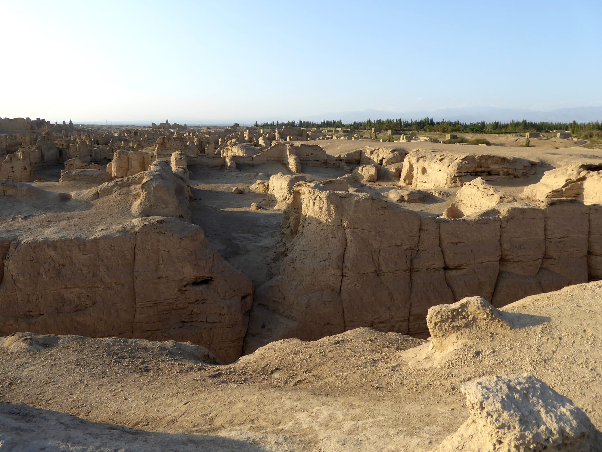
Sunlit earthen walls and sunken lanes of the ruined city of Jiaohe, with poplar trees and distant mountains beyond

Xi'an, the Silk Road & the Northwest, China

Turpan

The rammed-earth ruins of Jiaohe on a plateau outside Turpan. (Hiroki Ogawa / Wikimedia Commons · CC BY 3.0)

An oasis city in eastern Xinjiang, lying in the Turpan Depression, a basin that drops below sea level and records the highest summer temperatures in China. Watered by underground karez channels drawn from the Tian Shan, it has grown grapes for centuries and is surrounded by the ruined Silk Road cities of Jiaohe and Gaochang and the Buddhist caves at Bezeklik.

Neighbourhoods

  • Gaochang District centre
    • First-time visitors
    • Best for food
    • Close to public transport

    The small modern town at the middle of the oasis, with vine-covered pergolas shading the main streets, the bazaar, most hotels and the bus station. Everything in town is within a short walk or a cheap taxi ride, and the Emin Minaret stands on its eastern edge.

    Open in Maps
  • The vineyard belt
    • Scenery
    • Local life

    North and east of town the irrigated land is given over to grapes, trained on low trellises and dried in mud-brick drying houses whose pierced walls stand on every rise. Farm guesthouses and Uyghur villages sit among the vines.

    Open in Maps
  • Grape Valley and the northern gorge
    • Walks
    • Shade

    Where the oasis meets the foot of the Flaming Mountains, a narrow watered valley of vine tunnels, orchards and streams that is noticeably cooler than the plain. It is the usual retreat from the midday heat.

    Open in Maps
  • The eastern desert edge
    • History
    • Views

    The gravel plain east of the oasis, where the ruined city of Gaochang, the Astana burial ground and the Bezeklik caves lie along the base of the red mountains. There is no settlement to speak of, but this is where most of the sightseeing happens.

    Open in Maps

Things to do

Ancient cities

  • Jiaohe ruinslandmark

    The rammed-earth remains of a city carved into a river-island plateau west of town, capital of the Jushi kingdom and later a Tang garrison seat; part of the UNESCO Silk Roads listing.

    Open in Maps
  • Gaochanglandmark

    The walled ruins of a much larger city east of the oasis, a Chinese colony, then a Uyghur kingdom capital, destroyed in 14th-century warfare and inscribed by UNESCO in 2014.

    Open in Maps

Caves and tombs

  • Bezeklik Thousand Buddha Caveslandmark

    Buddhist cave shrines cut into a cliff above a gorge in the Flaming Mountains, painted between the 5th and 14th centuries and stripped of many murals by expeditions in the early 1900s.

    Open in Maps
  • Astana Cemeterylandmark

    The burial ground of Gaochang, where the dry desert preserved bodies, silks, documents and food offerings from the 4th to the 8th centuries.

    Open in Maps

In the oasis

  • Emin Minaretlandmark

    A tapering mud-brick minaret of 1777, patterned in brickwork and rising beside its mosque at the edge of town, the tallest minaret in China.

    Open in Maps
  • Turpan Museummuseum

    The city museum, holding preserved bodies, silks, clothing and Tang-dynasty documents excavated from the Astana graves outside the town.

    Open in Maps

Short trips from the town

  • Flaming Mountainsviewpoint

    A barren ridge of red sandstone east of the oasis whose gullies appear to burn in the afternoon sun, made famous by the novel Journey to the West.

    Open in Maps
  • Ayding Lakeattraction

    A dried salt lake bed about 35 kilometres south of town lying 154 metres below sea level, the lowest point in China.

    Open in Maps
  • Tuyoqattraction

    An old Uyghur village of earth-brick houses in a gorge east of the oasis, with Buddhist caves above it and a Muslim shrine long visited by pilgrims.

    Open in Maps

Seasonal events

  • Grape harvestAugust and September

    The vines are picked across the oasis and the crop is hung in ventilated brick drying houses, filling the roads with fruit lorries and roadside stalls.

  • Turpan Grape Festivallate summer

    A local festival around the harvest, with markets, music and dance in the town and in Grape Valley.

  • Eid al-Fitrvaries with the lunar calendar

    The end of Ramadan, marked with prayers and family visits among Uyghur and Hui residents; religious observance in Xinjiang is closely regulated.

Eat and drink

Long-standing places and food districts in Turpan. Hours, ratings and directions come from your maps app, always current.

Turpan classics

  • Laghmanrestaurant

    Hand-stretched wheat noodles under a stir-fry of mutton, peppers, tomato and onion, eaten at any hour in Uyghur restaurants around the bazaar.

    Open in Maps
  • Kebabs and nanrestaurant

    Mutton cubes grilled over charcoal with cumin and chilli, served with the round tandoor-baked flatbread that accompanies almost every meal.

    Open in Maps
  • Raisins and dried fruitmarket

    Green seedless raisins dried in the airy brick houses of the oasis, sold loose alongside dried apricots, figs, walnuts and mulberries.

    Open in Maps

Markets and food streets

  • Turpan bazaarmarket

    The covered market in the town centre, selling fruit, spices, hats and household goods, with kebab grills, samsa ovens and cold-noodle stalls among the aisles.

    Open in Maps
  • Grape Valley restaurantsneighborhood

    Open-air eating places under vine trellises in the valley about 10 kilometres east of town, serving pilaf, roast lamb, fruit and tea away from the heat of the plain.

    Open in Maps

Experience Turpan

History

The Turpan basin has been farmed and fought over for more than two thousand years. Its first known centre was Jiaohe, a city built on a steep-sided plateau between two river channels, capital of the Jushi kingdom and a place the Han dynasty contested with the Xiongnu in a long series of campaigns. Chinese settlers founded Gaochang on the plain to the east, and from the 5th century it was the seat of local dynasties, most durably the Qu family, whose rulers governed a Buddhist, Chinese-speaking city-state on the Silk Road.

The Tang absorbed the oasis in 640 and administered it as Xizhou; the monk Xuanzang stopped at Gaochang on his way to India and was pressed to stay. After the Tang withdrew, Uyghur groups displaced from Mongolia established the Kingdom of Qocho here in the 9th century, a state remembered for its Manichaean and Buddhist art, of which the Bezeklik murals are the surviving trace. Mongol overlordship followed, and from the 14th century the oasis converted to Islam, a change completed in the second half of the 15th century, after which the Buddhist caves were abandoned and many images defaced.

The Qing took the basin in the 18th century, and the Emin Minaret was begun in 1777 and finished the following year, in honour of the Turpan ruler Emin Khoja. In the early 20th century German, British, Russian and Japanese expeditions removed large quantities of murals, manuscripts and grave goods, much of which remains in foreign museums; some of the Bezeklik panels taken to Berlin were destroyed in the Second World War. In the modern era the oasis has lived on grapes, cotton, oil and coal, with the railway from 1962 and the high-speed line from 2014.

Culture & Customs

Turpan is a Uyghur oasis town, and its culture is that of the Tarim basin villages: Islam of the Sunni tradition, extended families, music played on the dutar and rawap at weddings, and a deep attachment to the vine. Grapes are more than a crop here; they shape the architecture, in the pierced brick drying houses that stand on every ridge, and the streets, which are roofed with vine trellises for shade. The image of Turpan raisins and melons is known across China.

Layers of older belief are visible in the landscape. Buddhist caves, Manichaean paintings and Nestorian Christian remains lie within a few kilometres of Muslim shrines, and the village of Tuyoq has been a pilgrimage site for centuries. The Flaming Mountains carry their own literary fame through Journey to the West, in which the monk's party must cross them, which brings Chinese visitors who come for the story as much as the geology.

Religious practice is tightly restricted across Xinjiang. Visitors are received warmly, but residents cannot safely discuss politics, religion or security, and those subjects are best left alone. Hospitality follows Uyghur form — tea and dried fruit offered immediately, food eaten with the right hand, guests urged to take more than they want.

Daily Life

About 690,000 people live in the Turpan municipality, most of them Uyghur, with Han and Hui minorities concentrated in the town and in the industrial areas. The built-up centre is small; the rest of the population is spread through farming villages across the irrigated land and along the roads that skirt the mountains.

Water rules everything. For centuries the oasis was watered by karez, a system of gently sloping underground tunnels that carries snowmelt from the Tian Shan foothills to the fields with little loss to evaporation, dug and maintained by hand over generations. Many channels have dried or been abandoned as deep wells, pumping and reservoirs took over, and the falling water table is a continuing worry. Grapes, cotton, melons and vegetables still dominate farming, and raisin processing, wine, textiles, oil and gas extraction, coal and a growing wind and solar industry make up the rest of the economy, with tourism important in the shoulder seasons.

Summer dictates the rhythm of the day. Work starts early, the middle of the day is spent indoors or under vines, and life resumes in the evening, when the bazaar and the pavement grills fill up and stay busy late — helped by the region running on Beijing time, two hours ahead of the sun. Security screening at stations, markets and road checkpoints is part of ordinary routine, and daily life is shaped by surveillance and by restrictions on religion and travel.

Food

Turpan eats Uyghur food. Laghman, the hand-stretched noodle with a mutton and pepper sauce, and polo, rice pilaf cooked with lamb and carrot, are the staples, along with samsa, lamb and onion pastries baked on the walls of a tandoor, and manta, steamed dumplings. Kebabs of mutton on iron skewers, dusted with cumin and chilli, are grilled on pavements everywhere from spring to autumn, and dapanji, big-plate chicken with potatoes and wide noodles, appears on most menus.

Nan is the bread: baked in a clay oven, stamped in the middle, sold in stacks in the morning and eaten with everything. Cold dishes matter in the heat — chilled noodles with vinegar and garlic, cucumber salads, yoghurt sold thick and plain or with sugar, and hand-churned ice cream sold from brass drums in the bazaar.

Fruit is what Turpan is known for throughout China. Seedless white grapes dry into the green raisins sold by the sack, and figs, mulberries, apricots, pomegranates and Hami melons ripen through the summer. The vine also yields local wine and grape juice, sold to visitors in Grape Valley. Tea is drunk all day, often with dried fruit and rock sugar, and fresh pomegranate juice is pressed on the street in autumn.

Planning tools

Budget

Turpan is cheap for food and simple hotels, and the town itself costs little. The expense is transport: the ruins, caves and lake bed are spread over tens of kilometres of desert with no useful public transport, so almost everyone hires a car and driver for a day, and several of the sites charge separate entry fees. Hotel choice for foreign visitors is narrowed by registration rules in Xinjiang.

Daily Budget Midrange
USD 75–160 (mid-range hotel, restaurants, site tickets, a car and driver for the desert sites)
Daily Budget Shoestring
USD 30–55 (budget hotel, noodle shops and bazaar food, shared cars and local buses)

Confirm that a hotel can register foreign guests before booking, and agree a full list of stops with a driver before setting out into the desert.

Best Time to Visit

April to early June and September to October are the comfortable months, and September adds the grape harvest. July and August are punishing, with afternoon temperatures regularly above 40°C and little shade at any of the ruins. Winter is cold, dry and very quiet, and spring can bring strong wind through the gap in the mountains.

Suggested Number of Days

A day and a half covers the main ruins, the caves and the town for most visitors. A little longer suits the outlying villages, the lake bed and a slower pace, which the summer heat makes necessary in any case.

First Visit
1–2 days
With Surroundings
2–3 days

Transportation

The town centre is small and walkable, with cheap taxis and three-wheelers for short hops. The sights lie scattered across the oasis and the desert beyond it, from about 10 to 50 kilometres out, and are usually visited by hired car, taxi for the day or an organised tour. Road checkpoints between towns are routine, and passports are inspected at them.

Start early and rest in the middle of the day in summer; the ruins have almost no shade and the heat peaks in mid-afternoon.

Airport & Station Connections

High-speed trains on the Lanzhou–Ürümqi line stop at Turpan North, putting Ürümqi about an hour away, with the older station at Daheyan some 50 kilometres from town on the conventional line. Buses run to Ürümqi and along the corridor east towards Hami. The nearest large airport is at Ürümqi, and a small airport serves the city itself.

Walkability

Central Turpan is flat, compact and shaded in places by vine pergolas over the pavements, and the bazaar, hotels and restaurants are all within a short walk. The minaret is on the edge of town, about half an hour on foot. Everything else is too far and too exposed to walk to, and in summer even short walks are best kept to the early morning and the evening.

Safety

Ordinary crime is very low. Xinjiang is under pervasive surveillance, with frequent checkpoints, identity scans and armed patrols; foreign visitors may be questioned, have their phones checked or be followed, and conversations about politics can endanger local people. The physical risk here is heat: summer temperatures are the highest in China and heatstroke and dehydration are real dangers at the unshaded sites.

Carry far more water than seems necessary, cover up against the sun, avoid the ruins in the middle of a summer day, and do not photograph checkpoints, police or detention facilities. Check current official travel advice before travelling.

Climate

The hottest and one of the driest places in China, in a basin that traps heat below sea level, with under 20 millimetres of rain a year and a huge annual temperature range. Wind funnels through the depression in spring.

Summer
extreme — July averages 33°C, with afternoons around 40°C and nights that stay warm
Winter
cold and dry — January averages about −7°C, with little snow

Local Customs

Turpan is largely Uyghur and Muslim. Modest dress is expected, pork is not served in local restaurants and alcohol is little used, though grapes here also go into wine sold to visitors. The right hand is used for eating. Photography of people needs permission, and photographing police, checkpoints or military sites is prohibited. Tipping is not customary and bargaining is normal in the bazaar.

Keep politics, religion and security out of conversation with residents, take shoes off where asked at shrines, and ask before entering a family's drying house or vineyard.

Common Payment Methods

The currency is the renminbi, counted in yuan. Payment is almost entirely by QR code through Alipay or WeChat Pay, which foreign visitors can link to an overseas card before arriving. Foreign cards are rarely accepted outside a few hotels, so carry cash for site tickets, market stalls and drivers, and draw it at bank ATMs in the town centre.