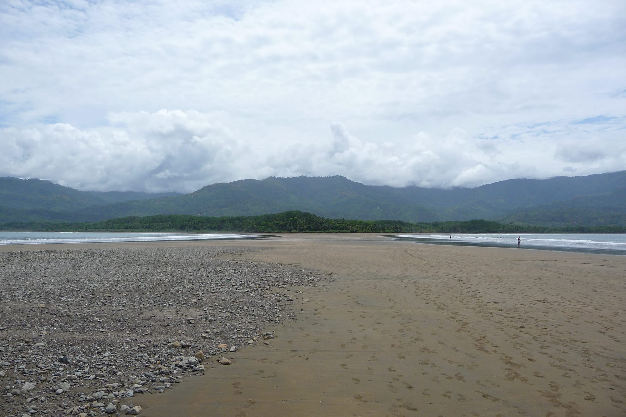
A wide sandbar of sand and pebbles stretching between two stretches of sea towards a forested shore and green mountains under cloud

Manuel Antonio, Monteverde & the Pacific Coast, Costa Rica

Uvita

The sandbar at Punta Uvita, exposed at low tide, in Ballena Marine National Park. (Yricordel / Wikimedia Commons · CC BY-SA 3.0)

A small town on Bahía Ballena, on Costa Rica's southern Pacific coast, beside the Ballena Marine National Park and its sandbar shaped like a whale's tail. Once a remote stop on the coast, Uvita has become the main tour hub of the Costa Ballena, with supermarkets, banks and restaurants serving a growing population of Costa Ricans and foreign settlers.

Neighbourhoods

  • Uvita centre
    • First-time visitors
    • Close to public transport
    • Shops and services

    The original settlement along the coastal highway, with the supermarkets, cash machines, bus stops and many of the restaurants. It is the practical base, with buses north and south along the coast.

    Open in Maps
  • Uvita Bahía
    • Beaches
    • Quiet stays
    • Nature

    The tourist area by the beach, about 2 km from the centre, next to the entrance of the national park. Most of it is easy to explore on foot, with cabinas, small hotels and beach bars among the trees.

    Open in Maps
  • The hills above Uvita
    • Views
    • Secluded stays

    Steep, forested slopes rising behind the town, where villas, eco-lodges and restaurants look out over the bay and the whale's tail. A car or taxi is needed for most of them.

    Open in Maps

Things to do

Ballena Marine National Park

  • Ballena Marine National Parkpark

    A national park created to protect the humpback whales' migration route, mostly sea with a strip of coast; humpbacks come here to breed from December to April.

    Open in Maps
  • The whale's tail at Punta Uvitabeach

    At low tide a sandbar appears linking the beach to Punta Uvita, and visitors walk out to its tip, whose shape from above resembles a whale's tail.

    Open in Maps
  • Playa Uvita, Playa Ballena and Playa Piñuelabeach

    The beaches inside the park, long and rarely crowded, used for swimming, snorkelling and walks at low tide.

    Open in Maps

Around town

  • Uvita waterfalltrail

    A waterfall in a canyon in the hills just north of the main road, with swimming holes surrounded by bamboo and flowering trees, reached by a steep path.

    Open in Maps
  • Whale-watching boat tripsattraction

    Boat tours from the bay to look for humpbacks and dolphins, one of the town's main tours, alongside snorkelling and diving trips.

    Open in Maps

Short trips from Uvita

  • Dominicalattraction

    A beach town to the north that began as a small fishing village and is known for large waves all year, popular with surfers.

    Open in Maps
  • Diquís stone sphereslandmark

    Pre-Columbian stone balls commonly attributed to the Diquís culture, found on the delta of the Térraba river to the south-east, where several of the settlement sites are protected.

    Open in Maps

Eat and drink

Long-standing places and food districts in Uvita. Hours, ratings and directions come from your maps app, always current.

Uvita classics

  • Sodas in Uvitaneighborhood

    Small traditional restaurants, found all over town, serving casados, gallo pinto and fresh seafood.

    Open in Maps
  • Beach bars at Uvita Bahíaneighborhood

    A few simple bars near the beach and on the main road, with karaoke, football on screen and local beer.

    Open in Maps

Experience Uvita

History

Long before the town existed, the southern Pacific coast was the land of the Diquís culture, to which the stone spheres found on the Térraba delta to the south-east are commonly attributed. In modern times Uvita and its neighbours, such as Dominical, which began as a small fishing village, grew up as small communities on a coast long considered remote.

Two things shaped the modern town. The government created the Ballena Marine National Park, protecting the bay and its shoreline as a safe area for migrating humpback whales and giving the town its best-known attraction. And the Costanera, the coastal highway, links Uvita with Quepos and the central Pacific to the north and with Ojochal and Coronado to the south, so that the coast route is now the quicker way from the capital.

Once considered remote, Uvita has since grown into the tourist and tour hub of the Costa Ballena. A large influx of foreigners has settled in the town and the hills around it, and grocery stores, banks, doctors and dentists have followed. Today it is the head town of Bahía Ballena district, which stretches along the coast from Dominical in the north.

Culture & Customs

The whales define Uvita's sense of itself. The park's name, Ballena, is Spanish for whale, and the bay itself is Bahía Ballena. Humpbacks from the north Pacific and from the far south reach the bay at different times of year, and whale watching is one of the town's main tours. The whale's-tail sandbar, visible from the hills above town, has become a well-known image of the coast.

The community is a mix of Costa Rican families and foreign settlers who arrived in large numbers in recent decades, and the town has a lively expatriate and local culture. Yoga, wellness retreats and eco-lodges are part of the scene in the hills, and as of 2019 the Envision festival took place in the area in February or March.

Evenings are low-key: a few beach and roadside bars hold karaoke nights, ladies' nights and screenings of football matches, and the beer is usually Imperial, a Costa Rican lager. Both Spanish and English are heard in the shops and restaurants, reflecting the mixed community.

Daily Life

Bahía Ballena district, of which Uvita is the head town, had an estimated population of about 4,400 in 2022. The district takes in Uvita and Bahía Ballena along with Dominical, Dominicalito, Playa Hermosa, San Josecito and smaller villages in the hills.

Tourism is the main business. Uvita is the hub for whale-watching trips, snorkelling and diving, horseback riding and other tours along the Costa Ballena, and the town is known for its many restaurants and places to stay. Services for the growing foreign community — grocery stores, banks, doctors and dentists — have followed, and the town is no longer considered remote.

Life is split between the two parts of town: the centre along the highway, with its supermarkets, banks and bus stops, and the quieter Bahía area by the beach and park. Buses into Bahía are less frequent than those on the highway, so many residents get about by bicycle, taxi or car. The tides set the rhythm at the beach, since the walk out along the sandbar is only possible at low water, and in the green season heavy rain falls most afternoons and nights.

Food

Uvita eats from the sea. Fresh fish and seafood are on almost every menu, from ceviche, white fish cured in lime with onion and coriander, to whole fried fish served with rice, salad and patacones, flattened and twice-fried green plantain. Arroz con camarones, rice with prawns, is a coastal standard.

Sodas, the small traditional restaurants found all over Costa Rica, are scattered through town and serve the casado at lunch — rice, beans, salad, fried plantain and a piece of fish, chicken or beef — and gallo pinto, rice and black beans fried together, at breakfast. Pizza, Mexican food and barbecue chicken reflect the town's mixed population, and at least one lodge near the park cooks with produce from its own farm.

Fresh tropical fruit is blended into batidos with milk or frescos with water. At the bars, Imperial, a Costa Rican lager, and Cacique, a Costa Rican spirit, are the usual drinks.

Planning tools

Budget

Uvita is cheaper than Manuel Antonio, with hostels, cabinas and sodas in the centre. Costs rise with lodges and villas in the hills, which often need a car, and with boat trips for whale watching and snorkelling. The national park charges a modest entry fee.

Daily Budget Midrange
USD 140–280 (hillside lodge, restaurant dinners, a whale-watching or snorkelling boat trip, a hire car)
Daily Budget Shoestring
USD 50–85 (hostel or cabina, soda meals, buses, park entry)

Pay for the park at the entrance by card, and time a visit to the whale's tail for low tide.

Best Time to Visit

Humpbacks from both hemispheres visit the bay at different times of the year — northern whales in the dry season months and southern ones in the second half of the year — so there are two whale-watching seasons. December to April is the driest and busiest period; the rest of the year is the green season, wetter and quieter.

Suggested Number of Days

Two or three days suit the park, the beaches and a boat trip. Allow four to six to add the neighbouring beach towns and the Diquís sites, or to wait out the weather in whale season.

First Visit
2–3 days
With Surroundings
4–6 days

Transportation

The town is split in two: the centre on the highway, with most services, and the Bahía area by the beach, about 2 km away. Bahía is easy to walk, but a bicycle or taxi helps between the two. Buses run north and south along the coastal highway, and a car is useful for the hills and the beaches beyond town.

Catch buses along the coast from the highway, where services are more frequent than in Bahía.

Airport & Station Connections

Uvita lies on the Costanera, the coastal highway down the Pacific. Buses from San José run either via Quepos along the coast or via San Isidro de El General over the mountains, and shuttle vans from Juan Santamaría International Airport take about three and a half hours by the coast. The nearest airport, Palmar Sur, to the south-east, has a daily scheduled flight from San José.

Walkability

Uvita Bahía is compact and flat, easy to walk to the beach and park entrance; the walk to the centre on the highway is about 2 km in the heat. Lodges in the hills are on steep, often unpaved roads that are hard on foot.

Safety

Costa Rica still compares well with its Central American neighbours, and crime that reaches visitors is usually petty theft or the occasional armed robbery — break-ins to parked rental cars, bag-snatching on beaches, and pickpocketing in San José. Along the Pacific coast theft is the main risk, including break-ins to cars at beach car parks, and rip currents are strong on many open beaches. Signs in the park warn of crocodiles in the small estuary, and the sandbar can be walked only at low tide.

Leave nothing in parked cars, swim only where conditions are calm, keep out of the estuary, and check tide times before walking out on the whale's tail. Check current official travel advice before travelling.

Climate

The southern Pacific coast is hot and humid all year and wetter than the central coast. The dry season runs from about December to April; heavy rain falls from May to November.

Summer
dry season (December–April): hot on the coast, around 30–33°C
Winter
green season (May–November): heavy afternoon and night rain on the coast, hot and humid; Costa Rica's coastal lowlands average around 27°C over the year

Local Customs

Uvita mixes long-standing Costa Rican families with a large community of foreign settlers, and both Spanish and English are widely heard. Life is informal; greetings in Spanish are appreciated.

Check whether a service charge is already on the bill before tipping, and do not feed wildlife or take shells and coral from the park.

Common Payment Methods

The currency is the Costa Rican colón, and US dollars are widely accepted for tours and lodging. The town centre has banks and cash machines; cards are accepted in most hotels, supermarkets and restaurants, and the park entrance takes cards only. Carry colones for buses and sodas.