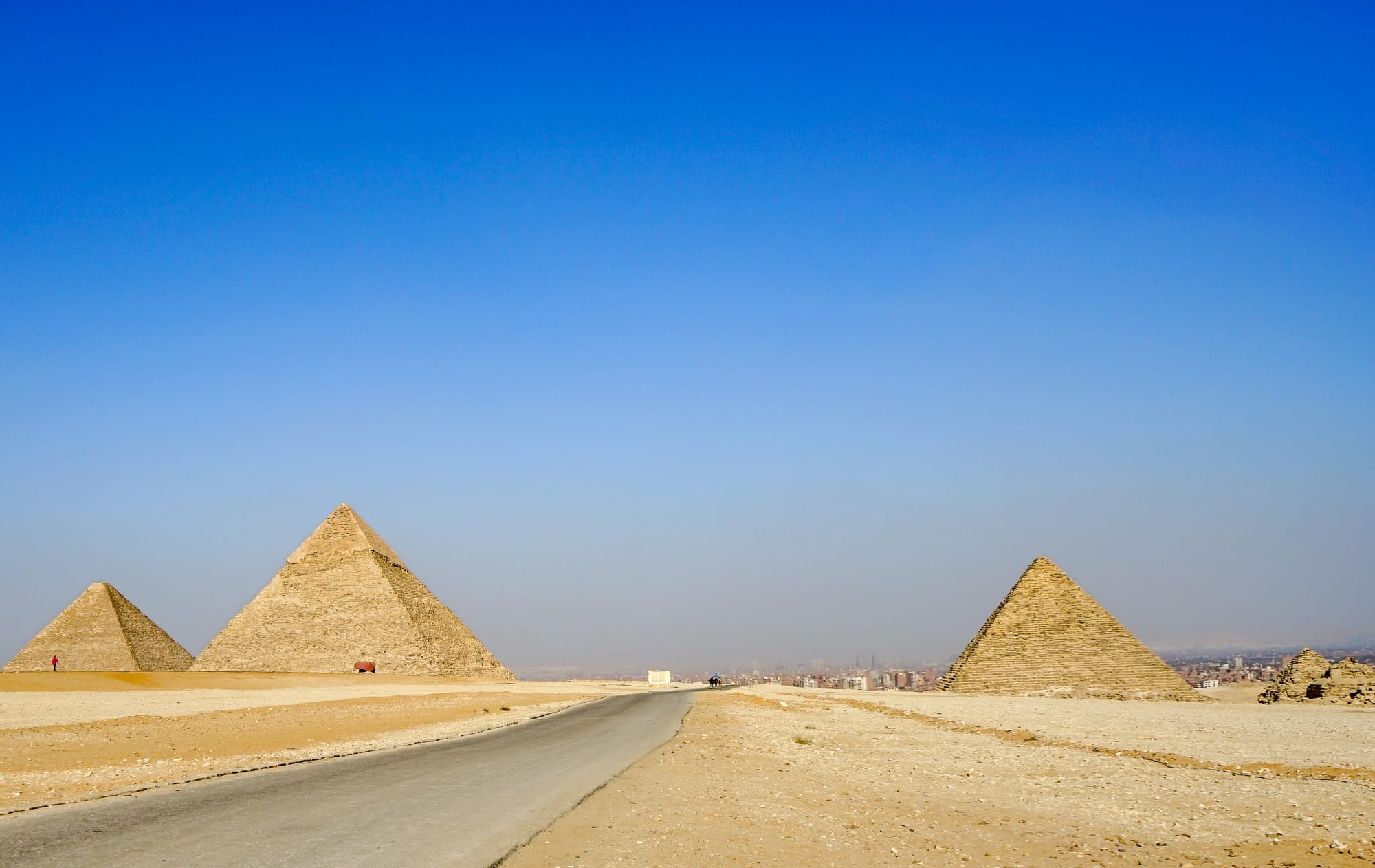
A road crossing the sandy Giza plateau between pyramids, with the hazy city stretching along the horizon

Cairo, Giza & the Faiyum, Egypt

Giza

The Giza plateau, with the pyramids above the desert road and the city beyond. (Nina R from Africa / Wikimedia Commons · CC BY 2.0)

A large city on the west bank of the Nile, facing Cairo and joined to it by bridges and the metro. Once a string of farming villages below the desert escarpment, it is now part of the Greater Cairo sprawl, with government offices, Cairo University and dense residential quarters running right up to the plateau where the pyramids of Khufu, Khafre and Menkaure and the Great Sphinx stand.

Neighbourhoods

  • Nazlet El-Semman and the pyramids road
    • First-time visitors
    • Close to the pyramids

    The dense quarter that has grown right up against the edge of the plateau, below the Sphinx. Small hotels with rooftop pyramid views, stables, bazaars and souvenir shops crowd the lanes, and the long Pyramids Road runs from here back towards the river.

    Open in Maps
  • Dokki
    • Close to public transport
    • Restaurants
    • Central

    A busy central district on the west bank across from Cairo's downtown, with ministries, embassies, the Agricultural Museum and its own metro stations. Cafés and cheap restaurants line the side streets between apartment blocks.

    Open in Maps
  • Mohandessin
    • Restaurants and cafés
    • Shopping

    A middle-class district planned in the 1940s and built up after 1952 for professional families, known for wide avenues such as Gameat El Dowal El Arabeya, its shops, chain restaurants and cafés, and a nightlife of juice bars and shisha terraces.

    Open in Maps
  • Agouza and the corniche
    • Riverside walks
    • Quiet and residential

    A riverside strip facing Zamalek across a narrow channel of the Nile, with a corniche walk, moored houseboats and floating restaurants, and older apartment buildings behind.

    Open in Maps
  • Imbaba
    • Local life
    • Markets

    A crowded working-class district in the north of the city, historically a farming and camel-market area, with street markets, small workshops and little tourism.

    Open in Maps
  • 6th of October City
    • Quiet and residential
    • Family attractions

    A desert satellite city west of the plateau, begun in 1979, with universities, factories, gated compounds and shopping malls. It is a long drive from the river but close to the western approaches of the pyramid fields.

    Open in Maps

Things to do

The pyramid plateau

  • Giza pyramid complexlandmark

    The royal cemetery on the desert plateau, with three pyramids, the Sphinx, queens' pyramids, causeways and fields of officials' tombs, a UNESCO World Heritage Site since 1979.

    Open in Maps
  • Great Pyramid of Khufulandmark

    Built around 2560 BC and originally about 146 metres tall, now about 138 metres without most of its casing, the oldest of the Seven Wonders of the Ancient World and the only one largely intact; narrow passages lead to the burial chamber inside.

    Open in Maps
  • Pyramid of Khafrelandmark

    The second pyramid, which looks taller because it stands on higher ground, and keeps the original polished limestone casing over its upper third.

    Open in Maps
  • Pyramid of Menkaurelandmark

    The smallest of the three main pyramids, its lower courses faced in granite, standing beside three small queens' pyramids.

    Open in Maps
  • Great Sphinx of Gizalandmark

    A limestone lion with a king's head, carved from the bedrock in the third millennium BC and about 20 metres high, guarding the causeway of Khafre.

    Open in Maps
  • Khufu shipattraction

    A full-size cedar boat buried in a sealed pit beside the Great Pyramid and excavated in 1954, moved in 2021 to the Grand Egyptian Museum.

    Open in Maps

Museums

  • Grand Egyptian Museummuseum

    The vast museum near the plateau, opened in November 2025, holding the complete Tutankhamun collection and thousands of other pharaonic objects.

    Open in Maps
  • Agricultural Museummuseum

    An old museum in Dokki, founded in the 1930s, with displays on farming, rural crafts and the plants and animals of the Nile Valley.

    Open in Maps

The city and the river

  • Cairo Universitylandmark

    Egypt's main national university, founded in 1908 and moved to Giza in 1929, its domed hall a landmark at the end of a broad avenue from the river.

    Open in Maps

Short trips from the city

  • Saqqaralandmark

    The necropolis of Memphis a short drive south, with the Step Pyramid of Djoser, the pyramid of Unas, painted nobles' tombs and the Serapeum.

    Open in Maps
  • Pyramid of Djoserlandmark

    The stepped pyramid of the 27th century BC at Saqqara, the earliest colossal stone building in Egypt, at the centre of a walled funerary complex.

    Open in Maps
  • Dahshurlandmark

    A quiet pyramid field further south, where Sneferu's Bent Pyramid and Red Pyramid record the shift to true pyramid building.

    Open in Maps
  • Memphislandmark

    The Old Kingdom capital at Mit Rahina, now an open-air museum around a fallen colossus of Ramesses II and an alabaster sphinx.

    Open in Maps
  • Abusirlandmark

    A small, little-visited Fifth Dynasty pyramid field between Giza and Saqqara, with sun temples and the ruined pyramids of Sahure and Nyuserre.

    Open in Maps

Seasonal events

  • Ramadan nightsthe month of Ramadan

    Days are quiet and the streets fill after sunset, with lanterns, food stalls and family gatherings that run late into the night across the city's districts.

  • Sham el-Nessimspring, the Monday after Coptic Easter

    A spring holiday kept by Egyptians of all faiths, when families picnic in the parks and along the riverbank with salted fish, spring onions and coloured eggs.

  • Eid al-Fitr and Eid al-Adhaafter Ramadan, and about two months later

    The two great feasts, when the riverside and the pyramid plateau fill with Egyptian families on holiday and hotels are heavily booked.

Eat and drink

Long-standing places and food districts in Giza. Hours, ratings and directions come from your maps app, always current.

Giza classics

  • Grill houses on Pyramids Roadrestaurant

    Charcoal grills serving kebab, kofta, grilled pigeon and mixed mezze are a fixture of the long avenue between the river and the plateau.

    Open in Maps
  • Koshari and ful counters in Dokkirestaurant

    Cheap specialist shops sell koshari by the bowl and ful and ta'meya sandwiches from morning until late, around the metro stations and university.

    Open in Maps

Food districts

  • Mohandessin restaurantsneighborhood

    The district's wide avenues hold much of the west bank's sit-down dining, from Egyptian and Levantine kitchens to seafood, cafés and shisha terraces.

    Open in Maps
  • Floating restaurants on the cornicheneighborhood

    Moored boats and houseboats along the Agouza and Dokki waterfront serve grills and mezze with the river and the Cairo skyline in view.

    Open in Maps

Experience Giza

History

Giza's story begins on the desert plateau above the floodplain, chosen in the 26th century BC by Khufu for his pyramid because it offered firm bedrock, a commanding position and a quarry close at hand. His son Khafre and grandson Menkaure followed, and the Sphinx was carved from an outcrop left by the quarrymen. Around the royal monuments lay a working landscape: causeways down to harbours on a river channel, temples, cemeteries of officials, and the settlement of the crews who built and supplied the tombs, whose bakeries and barracks have been excavated south-east of the Sphinx.

For most of the following four thousand years the plateau was a quarry and a curiosity while ordinary life went on below. Medieval builders stripped the smooth casing stones for Cairo's mosques and walls. The villages on the west bank — farming communities among palm groves and canals — were separate from the capital across the water until the 19th century, when Khedive Ismail drove a straight road out to the pyramids and bridged the Nile, partly to impress the guests arriving for the opening of the Suez Canal in 1869.

Modern Giza grew from that road. It became the seat of its own governorate, Cairo University moved out to it in 1929, and ministries, broadcasting studios and new residential districts filled the fields through the 20th century. Population pressure pushed building right to the boundary wall of the archaeological site and out into the desert at 6th of October City. Recent decades have brought a ring road, a new visitor centre at the pyramid site, and the Grand Egyptian Museum, which opened in November 2025 a short distance from the plateau.

Culture & Customs

Giza is not a separate world from Cairo — the two run into each other across the bridges, and people cross daily for work, study and family — but the west bank has its own character. It holds the national university, the state broadcasting studios and the film industry's production base, so students, actors, journalists and musicians are part of its everyday population, and the cafés of Dokki and Mohandessin have long been meeting places for them.

Closer to the plateau, life is shaped by the monuments. Families in Nazlet El-Semman and the surrounding quarters have worked in tourism for generations, as guides, drivers, stable keepers, bazaar traders and excavation workers, and a great deal of local knowledge about the site is passed down rather than taught. Horses and camels are a working presence, kept in stables along the desert edge. The relationship with visitors is direct and commercial, and a firm, friendly refusal is understood and expected.

Older village customs survive in the northern and western districts: weddings that close a street for the night, moulids at local shrines, and the strong Ramadan rhythm of long tables set out for the fast-breaking meal. Coptic families live throughout the city, with churches in most districts. Football is followed as intensely as in Cairo, and the clubs of the capital command loyalty on both banks.

Daily Life

Giza is Egypt's third-largest city, with about 4.5 million people in the city itself and about 9.5 million in the wider governorate, which also takes in 6th of October City and reaches far into the Western Desert. It functions as part of Greater Cairo: the metro, the bridges and the ring road carry an enormous daily flow of commuters in both directions, and traffic is the dominant fact of the day.

Work is government offices and services in Dokki and Agouza, the university and hospitals, media production, workshops and small industry in Imbaba and the northern districts, factories and logistics in 6th of October City, and tourism around the plateau. Tourism is the most exposed sector: when visitor numbers fall, whole neighbourhoods near the pyramids feel it within weeks.

Housing ranges from the villas and compounds of the desert suburbs to dense unplanned quarters of red-brick blocks built on land that was farmland a generation ago. Water, power and traffic are the everyday complaints, along with prices that have risen sharply since the pound's devaluations. Evenings are when the city relaxes: cafés and juice bars open late, the corniche and the riverside restaurants fill, and in summer nothing much happens outdoors until the sun is down.

Food

Giza eats what Cairo eats, with more of it cooked over charcoal. The long avenue between the river and the plateau is lined with grill houses serving kebab and kofta, and hamam mahshi, pigeon stuffed with rice or cracked green wheat, is a west-bank favourite, helped by the pigeon towers that once stood among the surrounding farmland. Hawawshi, flatbread packed with spiced minced meat and baked until crisp, and shawarma carved from the spit are the standard quick meals.

The cheap staples are everywhere: koshari shops selling nothing but the bowl of rice, macaroni, lentils, chickpeas, fried onions and tomato sauce; ful and ta'meya carts at dawn outside the university and the metro stations; liver and sausage sandwiches in the evening. Bread comes from baladi ovens in every street, and fruit and vegetable barrows follow fixed rounds through the residential districts.

Drinks and sweets follow the same pattern as the capital. Sugar cane juice is pressed to order, mango and guava juices are seasonal, and karkadeh, hibiscus tea, is drunk hot in winter and iced in summer. Dairy shops sell rice pudding and mahallabiya in small bowls, feteer meshaltet is baked in layers and eaten with honey or salty cheese, and during Ramadan the pastry counters fill with kunafa and qatayef. Tea and shisha in an ahwa, the traditional coffee house, close most evenings.

Planning tools

Budget

Costs are much like Cairo's, with one difference: the plateau is expensive. Foreigners pay far more than residents for the site, and extras add up — separate tickets to enter pyramids, the Grand Egyptian Museum, camel and horse rides, and a driver for Saqqara and Dahshur. Food, transport and hotels away from the pyramids are cheap.

Daily Budget Midrange
USD 75–150 (mid-range hotel, restaurant meals, a driver or guide for Saqqara and Dahshur, museum tickets)
Daily Budget Shoestring
USD 25–45 (budget hotel near the plateau, street food, the metro and ride-hailing, one major site)

Buy site tickets only at the official counters at the plateau entrances, and settle the price and the route of any camel or horse ride before getting on.

Best Time to Visit

October to April, when the open desert is comfortable to walk. December and January are the coolest and busiest. Early mornings are the best hours at the plateau in any season, before the heat, the haze and the tour coaches. Spring can bring dusty khamsin winds, and summer midday on the sand is punishing.

Suggested Number of Days

One full day covers the essentials and two allow a slower pace. Adding the pyramid fields further south brings the total to three or four days. Heat, traffic and the sheer size of the sites are what stretch the time.

First Visit
1–2 days
With Surroundings
3–4 days

Transportation

Giza sits on the Cairo metro, with stations at Dokki, Giza and along the line running south, and a station near the plateau is served by onward road transport. Ride-hailing apps are the simplest way to reach the pyramids and to move between districts. Microbuses cover local routes cheaply but are hard to use without Arabic. A monorail is being built across the west bank towards the desert cities.

Agree the destination and price before any taxi, camel or horse ride, and expect drivers to suggest a stop at a papyrus or perfume shop unless told otherwise.

Airport & Station Connections

Most visitors arrive from Cairo, 20 to 30 minutes away by road at a quiet hour and an hour or more at peak times, or by metro across the river. Cairo International Airport is about 30 kilometres north-east, an hour or more by road, and Sphinx International Airport lies west of the city on the desert side. Long-distance coaches to the Faiyum and the Western Desert oases leave from the west bank.

Walkability

The pyramid plateau itself is walked, and the distances there are longer than they look — the circuit past the three pyramids and the Sphinx is several kilometres over sand and rubble in full sun. The city below is a different matter: wide roads with fast traffic, broken pavements and few crossings make walking between districts tiring, so most journeys are made by car or metro.

Safety

Serious crime against visitors is uncommon and the plateau is heavily policed, but Giza is where Egypt's tourist hassle is at its most persistent: touts, unofficial guides, camel and horse handlers and sellers work the approaches and the site itself. Overcharging and pressure to buy are routine. The other risks are heat, loose footing on the sand and rock, and the traffic on the main roads.

Buy tickets only at official counters, agree prices before any ride at Giza, dress modestly away from hotels, and cross roads with local pedestrians. Check current official travel advice before travelling.

Climate

Hot desert with almost no rain. The open plateau is several degrees hotter and far more exposed than the streets below, with no shade and strong glare off the sand; wind blows dust across it for much of the year.

Summer
very hot on the plateau — days around 34–37°C, with strong sun and warm, dusty evenings
Winter
mild and bright — days around 18–22°C, cool mornings and the occasional shower

Local Customs

Small tips, baksheesh, are expected everywhere, including from site guards who offer to show a corner or take a photograph. Modest dress is normal, with shoulders and knees covered. Bargaining is the rule in the bazaars below the plateau. Photography of people, and of camels and horses, is often followed by a request for payment, so it is worth asking first.

Cameras are allowed on the plateau but rules differ inside the pyramids and in the museums; do not photograph police, checkpoints or military sites.

Common Payment Methods

The currency is the Egyptian pound. Site tickets and the larger museums take cards, and hotels and chain restaurants do too, but stalls, taxis, stables, small cafés and tips need cash. ATMs are common in Dokki, Mohandessin and along Pyramids Road, and small notes are the most useful.