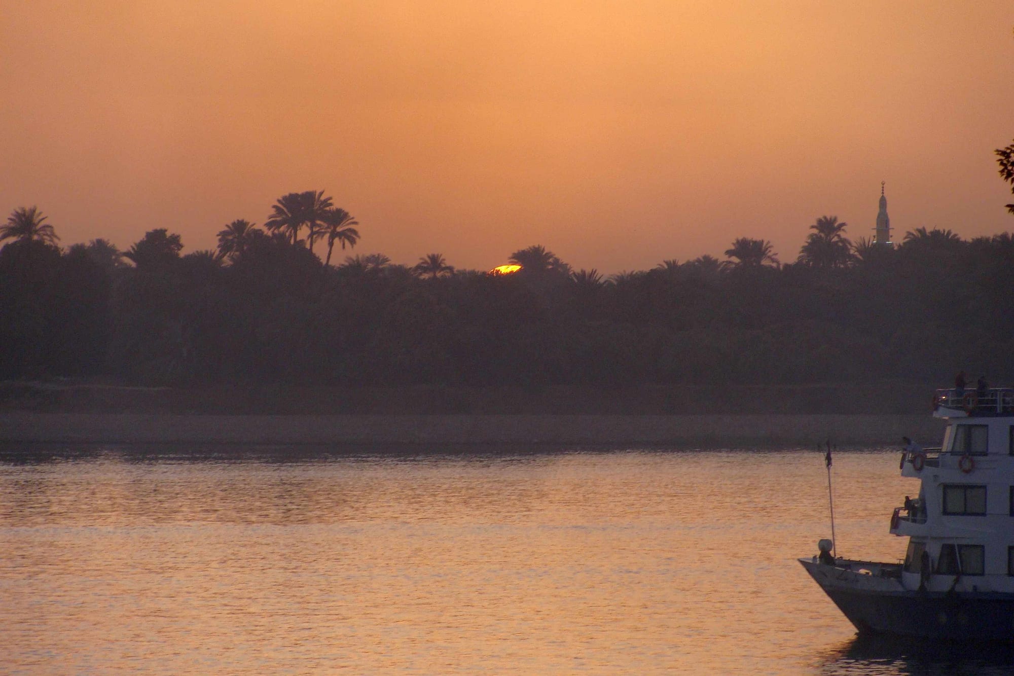
The Nile at dusk with a line of palm trees and a minaret silhouetted on the far bank and a white cruise boat moored at the right

Luxor, Aswan & the Nile Valley, Egypt

Kom Ombo

Sunset over the Nile at Kom Ombo, with palms and a minaret on the far bank. (Silar / Wikimedia Commons · CC BY-SA 3.0)

A sugar-growing town on the east bank of the Nile about 50 kilometres north of Aswan, known for the double temple that stands on a rise directly above the river and for the museum of mummified crocodiles beside it. The surrounding plain was farmed and settled in the 1960s by Nubians resettled from the villages lost under Lake Nasser.

Neighbourhoods

  • The temple bank
    • First-time visitors
    • Historic district

    The riverside rise a little north of the town centre, where the temple, the Crocodile Museum, the mooring front and a line of stalls sit within a few minutes of each other. Cruise boats tie up directly below, which makes this the only part of Kom Ombo most visitors see.

    Open in Maps
  • The town centre
    • Local life
    • Best for food

    A working provincial centre of shops, bakeries, tea houses, a market and the bus and service-taxi stands, about three kilometres from the temple. Nothing here is aimed at visitors, and prices and manners are local.

    Open in Maps
  • The Nubian villages
    • Local life
    • Quiet and residential

    The settlements spread across the plain west and north of the town, built from the 1960s for Nubian families moved off land drowned by Lake Nasser. Nubian languages are still spoken, and some houses keep the painted walls and decorated doorways of the old villages.

    Open in Maps
  • The cane plain
    • Countryside
    • Quiet and residential

    Flat irrigated farmland running back from the river to the desert edge, planted with sugarcane and cut by canals and tracks that carry the crop to the town's sugar factory at harvest. Villages of low houses, palms and threshing floors sit among the fields.

    Open in Maps

Things to do

Temples and museums

  • Temple of Kom Ombolandmark

    An unusual double temple built under the Ptolemies, with two parallel sets of gates, halls and sanctuaries — the southern half for the crocodile god Sobek, the northern for Haroeris, Horus the Elder — and reliefs that include a set of surgical instruments.

    Open in Maps
  • Crocodile Museummuseum

    A small museum beside the temple, displaying mummified crocodiles found in the local cemeteries along with coffins, stelae and votive objects connected with the cult of Sobek.

    Open in Maps
  • The Nile mooring frontviewpoint

    The bank below the temple, where cruise boats and feluccas tie up and the columns are lit after dark — the classic view of the site from the water.

    Open in Maps

Markets and local life

  • Daraw camel marketmarket

    In the town six kilometres south, long the most important camel market in Egypt, where animals driven up from Sudan along the desert routes are traded in the early morning, mainly on market days.

    Open in Maps

Short trips from the town

  • Gebel el-Silsilaattraction

    The narrow sandstone gorge downstream whose quarries supplied stone for temples the length of Egypt, with rock-cut chapels and inscriptions on both banks.

    Open in Maps
  • Philae temple complexlandmark

    The temple of Isis near Aswan, moved stone by stone to Agilkia Island between 1977 and 1980 to save it from the water between the two dams.

    Open in Maps
  • Temple of Edfulandmark

    The temple of Horus downstream at Edfu, among the best preserved ancient temples in Egypt, with its roof and pylon intact.

    Open in Maps
  • Nubian Museummuseum

    In Aswan, the museum of Nubian history and culture, covering the archaeology rescued before Lake Nasser rose and the life of the villages that were lost.

    Open in Maps

Seasonal events

  • The sugarcane harvestwinter, roughly December to April

    Cutting and hauling fill the roads with cane trailers bound for the sugar factory, which works through the winter; it is the busiest and most visible season in the farming year.

  • Ramadanvaries with the lunar calendar

    Days are quiet and the market shuts in the afternoon; the town comes alive after sunset, with lamps over the streets and families eating late.

  • Eid al-Adhavaries with the lunar calendar

    The feast of sacrifice, marked with shared meat, visits between families and crowds along the riverfront in the evening.

Eat and drink

Long-standing places and food districts in Kom Ombo. Hours, ratings and directions come from your maps app, always current.

Kom Ombo classics

  • The town marketmarket

    Vegetables, dates, cheese, spices and bread sold from stalls in the centre, with cane juice pressed at the roadside in winter.

    Open in Maps
  • Grill and ful kitchens in the centrerestaurant

    Everyday Upper Egyptian food — ful, ta'meya, koshari, grilled chicken and kofta — eaten standing or at plastic tables on the pavement.

    Open in Maps
  • Nubian cooking in the villagesrestaurant

    Okra and meat stews, griddle-baked flatbread and lentil dishes, cooked at home and in a few guesthouses among the resettlement villages.

    Open in Maps

Experience Kom Ombo

History

The settlement takes its name from the mound it stands on — Kom Ombo, the mound of Ombos, ancient Nubt, a place whose position mattered long before the temple was built. It sat where the desert routes from the gold mines of the Eastern Desert and the caravan roads from Nubia met the river, and it controlled a broad stretch of cultivable land. Crocodiles basked on the sandbanks below, and the town's chief god was Sobek, the crocodile, worshipped alongside the falcon god Haroeris.

The double temple that survives was begun in the 2nd century BC under Ptolemy VI and added to by later Ptolemies and in the Roman period. Its plan is symmetrical, with two entrances, two colonnaded halls and two sanctuaries, so that neither god took precedence. Floods, earthquakes and stone robbing wrecked much of the outer structure, and the river has eaten away part of the site; what remains was cleared of debris by Jacques de Morgan in the 1890s. Hundreds of mummified crocodiles were found in the cemeteries nearby.

The modern town is largely a creation of the 20th century. Land reclamation and irrigation turned the plain into sugarcane and cereal country, a large sugar factory drew workers from Qena and Sohag, and in the 1960s, when the Aswan High Dam flooded Nubia, tens of thousands of Nubians were resettled here in new villages on that reclaimed land, far from the river they had lived beside. The two histories — the pharaonic mound and the resettlement — sit uneasily side by side.

Culture & Customs

Kom Ombo is one of the few places where Sa'idi and Nubian Egypt live in the same district. In the villages of the plain, Nubian languages are spoken at home, weddings last for days with tar drums and singing, and house walls and doorways are sometimes painted in the bold patterns that were a mark of the old villages. Older people still speak of the lands under the lake, and the memory of the move is passed down as a defining family story.

The town itself follows Upper Egyptian custom: family first, respect for age, an unhurried and formal politeness, and a mosque-centred week. Ramadan reorders the day entirely, and the two Eids empty the shops and fill the houses. The Coptic minority keeps its own churches and feasts, as it does throughout the valley.

The camel market at Daraw, a short way south, is part of the area's identity as much as a commercial event: traders, drovers and buyers gather at first light around animals brought north along the old desert routes from Sudan. Away from that, culture is rural and practical — the harvest, football, the evening in the coffee house, and a strong local pride in a temple that thousands of foreigners come to see and few of them leave the riverbank to look beyond.

Daily Life

Roughly 60,000 people live in the town and the villages of the surrounding plain, and it works as the market and service centre for all of them. Irrigated sugarcane and cereals are the economic backbone, and the harvest sets the rhythm of winter, when the cane goes to the sugar factory, which also makes molasses and particleboard; wheat, vegetables and dates fill out the farming year. Government jobs, schooling, trade and transport employ most of the rest, and tourism touches only the narrow strip around the temple.

Days begin before dawn in the fields and slow to nothing through the middle of the day. The market, the tea houses and the corniche fill again in the late afternoon and stay busy after dark. Getting about is by microbus, tuk-tuk, motorbike and cart; the train station links the town north and south along the valley.

The pressures are familiar across Upper Egypt: high youth unemployment, migration to Cairo, the Red Sea resorts and the Gulf, inflation that has repeatedly outpaced wages, and thin public services. For the Nubian villages there is an additional, long-running question of compensation and of claims to return to land nearer the water, which remains unresolved decades after the move.

Food

The food is Upper Egyptian, built around bread and pulses. Ful medames, fava beans slow-cooked and dressed with oil, lemon and cumin, and ta'meya, the fava-bean falafel fried crisp, are breakfast for most households. Bread is the flat aish baladi, with sun-risen aish shamsi baked in the villages. Koshari, the bowl of rice, lentils, macaroni, chickpeas, fried onion and tomato sauce, is the cheap midday meal.

Nubian cooking adds another layer: stews of okra or meat cooked slowly with tomato, lentil dishes, and flatbread baked on a flat griddle rather than in an oven. Fish from the Nile is fried or grilled and eaten with bread, salad and tahini. Meat is mostly kept for feasts and weddings, when whole animals are slaughtered and shared, and roast pigeon appears at celebrations.

Sugar is everywhere, as it should be in cane country. Fresh cane juice is pressed at roadside stalls through the harvest, and 'asal iswid, the dark molasses boiled from the cane, is mixed with tahini and scooped up with bread. Tea comes strong and heavily sweetened, karkadeh, the red hibiscus infusion, hot in winter and iced in summer, and dates are sold loose in the market by the kilo.

Planning tools

Budget

Costs here are low. The temple and museum tickets are the main expense, and food, tea and local transport cost very little. Accommodation in the town is limited and basic, since almost everyone sleeps on a cruise boat or in Aswan, so those who do stay spend less than they would in the city.

Daily Budget Midrange
USD 75–170 (cruise cabin or a room in Aswan, a guide, several site tickets, a car and driver)
Daily Budget Shoestring
USD 25–40 (simple room, market and street food, trains or minibuses, site tickets)

Carry small notes for tickets, tips and taxis; agree the fare before taking a taxi or tuk-tuk out to Daraw.

Best Time to Visit

October to April. The cruise season fills the mooring front from December to February, and the temple is at its quietest early and late in the day. Winter is also the cane harvest, which is when the town itself is busiest. Summer is very hot, and anything outdoors is best done soon after sunrise.

Suggested Number of Days

The temple and museum take a couple of hours, which is what a cruise stop allows. Adding the camel market at Daraw and the villages of the plain makes a full day or two, usually from a base in Aswan.

First Visit
Half a day
With Surroundings
1–2 days

Transportation

The town is small and flat, and taxis, tuk-tuks and shared minibuses cover the few kilometres between the centre, the temple and the railway station. Trains on the Cairo–Aswan line stop here, and service taxis and microbuses run constantly to Aswan and Edfu along the river road.

Fix the price, including any waiting time, before the journey starts.

Airport & Station Connections

Kom Ombo is about 50 kilometres north of Aswan by road, an hour or less by taxi or minibus, and roughly 60 kilometres south of Edfu. Trains stop at the town's station. Most visitors, though, arrive by cruise boat on the Luxor–Aswan run and moor directly below the temple. The nearest airport is at Aswan.

Walkability

The temple, the museum and the moorings are a single easy walk on the level, and the town centre is compact. The three kilometres between centre and temple are hot, dusty and unshaded, so most people ride. There are few pavements, and traffic mixes cars, tuk-tuks, carts and tractors.

Safety

A calm farming town with a heavily guarded archaeological site. Visitors meet touting and hard bargaining around the temple stalls rather than crime. The practical risks are the traffic on the river road, the heat, and unfenced canals and irrigation channels in the fields.

Follow police instructions on escorts in Middle Egypt, stay away from the border zone south of Lake Nasser, and drink plenty of water in the heat. Check current official travel advice before travelling.

Climate

Hot desert climate with effectively no rain and clear skies nearly every day. The irrigated plain makes the air a little less dry than the open desert. Spring brings dusty khamsin winds, and winter nights are cool.

Summer
extremely hot and dry, regularly 40°C or more in the afternoon
Winter
warm and sunny, about 22–26°C by day, with cool nights

Local Customs

The town is conservative and mixed, with Sa'idi Upper Egyptian and Nubian families living side by side. Modest dress covering shoulders and knees is expected, greetings are lengthy and sincere, and small tips, baksheesh, accompany most services. People should be asked before being photographed, especially women and at the camel market.

During Ramadan do not eat, drink or smoke in the street during daylight; alcohol is served on cruise boats rather than in town.

Common Payment Methods

The currency is the Egyptian pound, and cash is the only reliable means of payment. Cards are accepted on cruise boats and almost nowhere else, ATMs are limited, and small denominations are needed for tickets, tips and transport.